- Maryland Route 197
-
Maryland Route 197
Laurel–Bowie Road 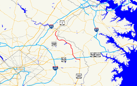
Maryland Route 197 highlighted in redRoute information Maintained by MDSHA Length: 14.64 mi[1] (23.56 km) Major junctions South end:  US 301 in Bowie
 US 50 in Bowie
 MD 450 in Bowie
 MD 295 in South Laurel
North end:  MD 198 in Laurel
Highway system Maryland highway system
Interstate • US • State • Minor • Former • Turnpikes←  I-197
I-197MD 198 →Maryland Route 197 (MD 197) is a state highway in the U.S. state of Maryland. Known for most of its length as Laurel–Bowie Road, the state highway runs 14.64 mi (23.56 km) from U.S. Route 301 (US 301) in Bowie north to MD 198 in Laurel. In addition to being the main connection between Bowie and Laurel, MD 197 provides access to Patuxent Wildlife Research Center and Bowie State University. The state highway is part of the National Highway System between US 50 in Bowie and the Baltimore-Washington Parkway in South Laurel as an intermodal connector to the Bowie State MARC station.[2]
MD 197 originally consisted of only Laurel–Bowie Road. The Collington Road section between US 301 and MD 450 was added in the mid 1950s. The northern terminus in Laurel was realigned and subsequently the whole Laurel section was expanded to a divided highway in the 1970s. Old Town Bowie was bypassed with a divided highway and the section between US 301 and US 50 was expanded to a divided highway in the early 1990s.
Contents
Route description
 MD 197 within the Patuxent Wildlife Research Center
MD 197 begins at an intersection with US 301 (Crain Highway) in Bowie. The state highway, named Collington Road, heads northwest as a four-lane divided highway with a speed limit of 45 mph (72 km/h) through a mix of shopping centers and dense residential subdivisions.[1] After passing Mitchellville Road, MD 197 expands to six lanes and passes Bowie Town Center, then meets US 50 at a partial cloverleaf interchange.[3] Beyond US 50, the state highway turns north and reduces to a two-lane road with a speed limit of 40 mph (64 km/h) surrounding by residential subdivisions.[1] After passing Tulip Grove Drive, which leads to the Belair Stable Museum, MD 197 reaches Old Annapolis Road, which is the old alignment of MD 450.[3] Old Annapolis Road heads west to the hamlet of Collington. After passing Old Annapolis Road, MD 197 expands to a four-lane divided highway, its name changes to Laurel–Bowie Road, and it intersects MD 450.[1][3]
MD 197 continues north from MD 450 as a five-lane road with center turn lane through residential subdivisions.[3] After passing the staggered intersections with Old Chapel Road, the speed limit drops to 35 mph (56 km/h) and the state highway passes Bowie Golf and Country Club on the west.[1][3] MD 197 then becomes a four-lane divided highway with a speed limit of 45 mph (72 km/h) through a forested area and passes under the Washington, Baltimore and Annapolis Trail and over Horsepen Branch.[1][3] The state highway intersects Race Track Road, named for defunct Bowie Race Track to the east. The westbound direction leads to MD 564 and Old Town Bowie.[3] MD 197 turns northwest and passes Jericho Park Road, which provides access to Bowie State University and the Bowie State MARC station.[3] After crossing the Amtrak Northeast Corridor and MARC's Penn Line and passing the Don S. S. Goodloe House, the state highway reduces to two lanes and enters Patuxent Research Refuge.[3] After intersecting Old Laurel–Bowie Road, an old alignment of MD 197, the state highway passes the entrances to several research facilities of the Patuxent Wildlife Research Center, as well as the historic home Snowden Hall.
After the intersection with Powder Mill Road, which leads to the Beltsville Agricultural Research Center, MD 197 leaves the refuge and passes several residential subdivisions in South Laurel.[3] The state highway expands to a four-lane divided highway ahead of the partial cloverleaf interchange with the Baltimore-Washington Parkway, which sees the two directions of MD 197 temporarily split with a wide median.[3] After the median closes, MD 197 expands to three lanes southbound.[3] The state highway meets Muirkirk Road across from a shopping center, then passes between Patuxent River Park on the east and the grounds of Montpelier Mansion on the west.[3] Beyond the intersection with Montpelier Drive and Brock Bridge Road, MD 197 enters an area of apartment complexes, then turns north and intersects Contee Road. The state highway continues north past a shopping center and more apartment complexes on the west, and historic Snow Hill, single-family homes and a park and ride on the east, then crosses Crow Branch, gains a third lane northbound, and intersects Cherry Lane.[3] As MD 197 bears to the northeast, its old alignment, Bowie Road, splits off to the north, and the state highway crosses Bear Branch and enters the city limits of Laurel.[1] MD 197 then meets its northern terminus at MD 198 (Fort Meade Road).
History
A short stretch of MD 197 was paved in South Laurel in 1927.[4] By 1930, the state highway was paved from Powder Mill Road in South Laurel to its northern terminus in Laurel, as well as from MD 450 at Collington to the center of Bowie.[5] The stretch of road in between was under construction. This middle segment was completed by 1933.[6] MD 197 followed much the same route as today, with a few exceptions:
- In Bowie, MD 197 turned west at the Washington, Baltimore and Annapolis Electric Railway to head into Old Town Bowie, following 11th Street and Chestnut Avenue within town, then heading north on what is today Old Laurel–Bowie Road.
- In Laurel, MD 197 followed Bowie Road from near Cherry Lane to US 1.
- The stretch south of MD 450 was not included.[7]
MD 197 was extended south to its current terminus at US 301 in 1955.[8] In 1970, MD 197 was extended to MD 198 along new alignment in Laurel.[9][10] MD 197 was also widened to a four-lane divided highway between MD 198 and the Baltimore–Washington Parkway in 1976.[9][11] The bypass of Old Town Bowie, which followed the alignment of Jericho Park Road near Bowie State University and utilized a grade separation of the Penn Line completed in 1981, was completed between 1989 and 1993.[9][12] Finally, the stretch of MD 197 between US 301 and just north of US 50 was expanded to a multi-lane divided highway in 1990.[9]
Junction list
The entire route is in Prince George's County.
Location Mile
[1]Destinations Notes Bowie 0.00 US 301 (Crain Highway) – Upper Marlboro, Baltimore, AnnapolisSouthern terminus 1.65 US 50 (John Hanson Highway) – Annapolis, WashingtonUS 50 Interchange 11 3.08 Old Annapolis Road west Old alignment of MD 450 3.28 MD 450 (Annapolis Road) – Bowie, Lanham5.76 Race Track Road to  MD 564 west – Old Town Bowie
6.21 Jericho Park Road – Bowie State University Unsigned MD 197C 7.92 Old Laurel–Bowie Road – Old Town Bowie Old alignment of MD 197 South Laurel 11.70 MD 295 (Baltimore–Washington Parkway) – Baltimore, WashingtonPartial cloverleaf interchange Laurel 14.14 Bowie Road - Laurel Old alignment of MD 197 14.64 MD 198 (Fort Meade Road) – Laurel, Fort MeadeNorthern terminus References
- ^ a b c d e f g h "Highway Location Reference: Prince George's County" (PDF). Maryland State Highway Administration. 2008. http://apps.roads.maryland.gov/KeepingCurrent/performTrafficStudies/dataAndStats/hwyLocationRef/2008_hlr_all/co16.pdf. Retrieved 2010-02-10.
- ^ Federal Highway Administration (August 2003) (PDF). National Highway System: Washington, DC-MD-VA (Map). http://www.fhwa.dot.gov/planning/nhs/maps/md/washingtondc_md.pdf. Retrieved 2010-02-11.
- ^ a b c d e f g h i j k l m n Google, Inc. Google Maps – Maryland Route 197 (Map). Cartography by Google, Inc. http://maps.google.com/maps?f=d&source=s_d&saddr=md-197+and+us+301+bowie,+md&daddr=md-197+and+jericho+park+road+bowie,+md+to:md-197+and+irving+st+laurel,+md&hl=en&geocode=%3BFQSTUwIdIV1s-ynHJbVWV-i3iTHOY8-OCO1kAg%3BFX6MVAIdo3tr-yknJ_u5bt23iTEVSHSiDgtxyA&mra=ls&sll=39.063449,-76.813316&sspn=0.121823,0.308647&ie=UTF8&t=h&z=11. Retrieved 2010-02-11.
- ^ Maryland State Highway Administration (JPG). Map of Maryland (Map) (1927 ed.). http://www.mdhighwaycentennial.com/images/template/gallery/maps/1927SIDE1.jpg. Retrieved 2010-02-11.
- ^ Maryland State Roads Commission (JPG). Map of Maryland (Map) (1930 ed.). http://commons.wikimedia.org/wiki/File:Maryland_State_Highway_Map_-_1930.jpg. Retrieved 2010-02-11.
- ^ Maryland State Roads Commission (PDF). Map of Maryland (Map) (1933 ed.). http://commons.wikimedia.org/wiki/File:Maryland_State_Highway_Map_-_1933.pdf. Retrieved 2010-02-11.
- ^ Maryland State Roads Commission (PDF). Map of Maryland (Map) (1939 ed.). http://commons.wikimedia.org/wiki/File:Maryland_State_Highway_Map_-_1939.pdf. Retrieved 2010-02-11.
- ^ Maryland State Roads Commission (PDF). Map of Maryland (Map) (1955 ed.). http://commons.wikimedia.org/wiki/File:Maryland_State_Highway_Map_-_1955.pdf. Retrieved 2010-02-11.
- ^ a b c d Svirsky, Alexander. "National Bridge Inventory Database". http://nationalbridges.com/. Retrieved 2010-02-11.
- ^ Maryland State Roads Commission (PDF). Map of Maryland (Map) (1970 ed.). http://commons.wikimedia.org/wiki/File:Maryland_State_Highway_Map_-_1970.pdf. Retrieved 2010-02-11.
- ^ Maryland State Highway Administration (PDF). Map of Maryland (Map) (1980 ed.). http://commons.wikimedia.org/wiki/File:Maryland_State_Highway_Map_-_1980.pdf. Retrieved 2010-02-11.
- ^ "Traffic Volume Map" (PDF). Maryland State Highway Administration. 1993. http://www.marylandroads.com/Traffic_Volume_Maps/93_Traffic_Volume_Maps.pdf. Retrieved 2010-02-11.
External links
Roads in Prince George's County, Maryland Maryland State Highways 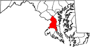
U.S. Routes Interstate Highways Roads by name Categories:- State highways in Maryland
- Roads in Prince George's County, Maryland


Wikimedia Foundation. 2010.