- Forty Mile County No. 8, Alberta
-
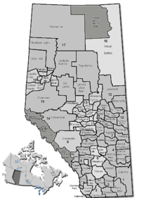
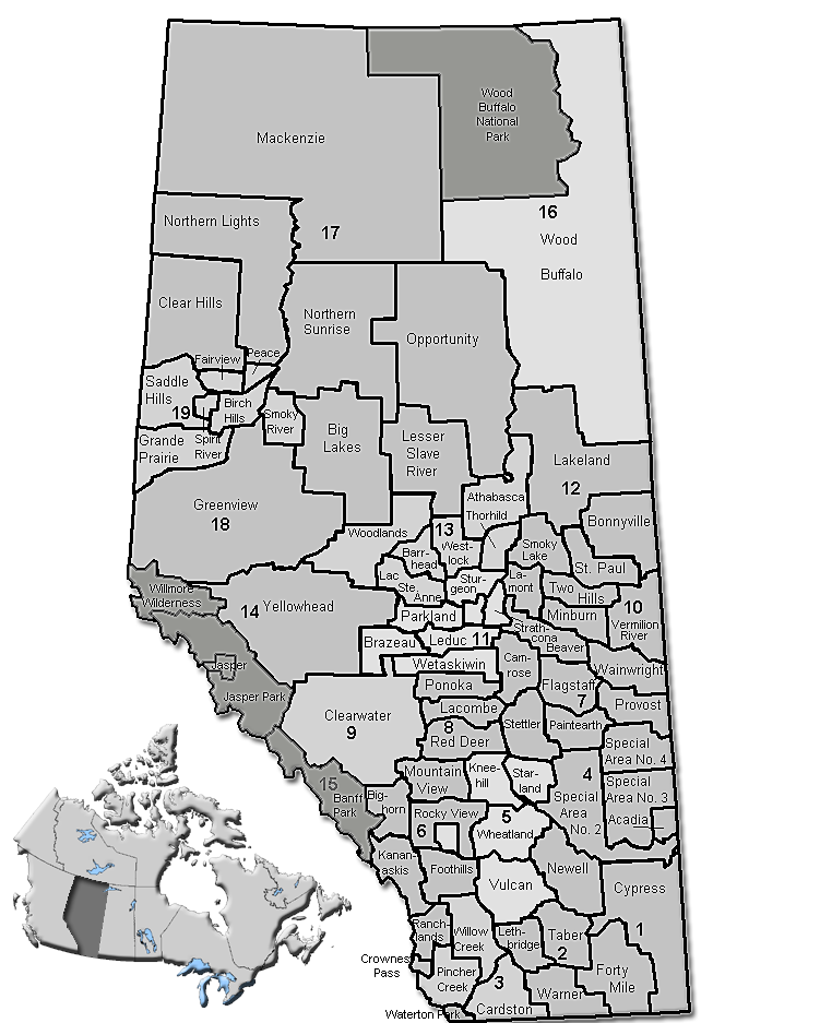
County of Forty Mile No. 8 — Municipal district — Location of Forty Mile No. 8 in Alberta
Coordinates: 49°28′44″N 111°26′25″W / 49.47889°N 111.44028°WCoordinates: 49°28′44″N 111°26′25″W / 49.47889°N 111.44028°W Country  Canada
Province  Alberta
Region Southern Alberta Census division No. 1 Established 1954 Incorporated 1958 Government[1] – Reeve Tom H. Thacker – Governing body County of Forty Mile Council – Municipal seat Foremost Area – Total 7,229.84 km2 (2,791.5 sq mi) Population (2006)[2] – Total 3,414 – Density 0.5/km2 (1.3/sq mi) – Dwellings 945 Time zone MST (UTC-7) Website County of Forty Mile No. 8 The County of Forty Mile No. 8 is a municipal district in south eastern Alberta, Canada.
It is located in Census Division 1, east of Medicine Hat. The municipal seat is in Foremost.
Contents
Demographics
In 2006, County of Forty Mile had a population of 3,414 living in 945 dwellings, a 0.5% decrease from 2001. The county has a land area of 7,229.84 km2 (2,791.46 sq mi) and a population density of 0.5 /km2 (1.3 /sq mi).[2]
In 2001, the municipal district had a population of 3,168 in 947 dwellings, a 1.9% decrease from 1996. On a surface of 7,215.27km² it had a density of 0.4 inhabitants/km².[3]
Communities
The following communities are located in this municipal district:[4]
Towns
Villages
Hamlets
- Burdett (dissolved from village status on January 1, 2003)
- Etzikom
- Manyberries
- Orion
- Skiff
Other unincorporated communities
- Aden
- Altorado
- Conquerville
- Legend
- Nemiscam
- Pakowki
- Whitla
- Winnifred
See also
- List of communities in Alberta
- List of municipal districts in Alberta
References
- ^ Alberta Municipal Affairs: Municipal Officials Search
- ^ a b Statistics Canada (Census 2006). "County of Forty Mile No. 8 - Community Profile". http://www12.statcan.ca/english/census06/data/profiles/community/Details/Page.cfm?Lang=E&Geo1=CSD&Code1=4801008&Geo2=PR&Code2=48&Data=Count&SearchText=Forty%20Mile%20County%20No.%208&SearchType=Begins&SearchPR=01&B1=All&GeoLevel=&GeoCode=4801008. Retrieved 2007-06-11.
- ^ County of Forty Mile community profile - Statistics Canada. 2002. 2001 Community Profiles. Released June 27, 2002. Last modified: 2005-11-30. Statistics Canada Catalogue no. 93F0053XIE
- ^ Municipal Profile - Alberta Municipal Affairs
External links
- County of Forty Mile (Official site)

Municipal District of Taber Cypress County County of Warner No. 5 
Cypress County  County of Forty Mile No. 8

Toole County Liberty County Hill County Categories:- Forty Mile County, Alberta
Wikimedia Foundation. 2010.