- Dahlgren Railroad Heritage Trail
-
Dahlgren Railroad Heritage Trail 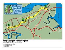
Map of the Dahlgren Railroad Heritage Trail Length 15.7 mi (25.27 km) Location King George County, Virginia, United States Trailheads State Route 605 (Bloomsbury Road)/ near State Route 614 (Owens Road) Use Hiking, bicycling, horseback riding The Dahlgren Railroad Heritage Trail (DRHT) is a trail that follows an old railroad bed in King George County, Virginia.[1]
The railroad line was built by the federal government during World War II to serve a United States Navy base in Dahlgren; the line was later sold to the Richmond, Fredericksburg and Potomac Railroad and subsequently CSX Transportation before being abandoned.[2]
The DRHT is a 15.7-mile (25.3 km) trail from the western edge of King George County to the Naval Surface Warfare Center, Dahlgren Division. Intended for use as a public "Rails-to-Trails" project, the trail winds through rural King George and accommodates non-motorized, recreational users including hikers, bikers, horseback riders, and runners. The Friends of the DRHT hope to eventually make the trail a public resource for King George County, and to connect it to similar trails in Fredericksburg, Virginia. A projected future bike trail across an expansion to the Governor Nice bridge would provide a connection to trails in Maryland.
The trail opened with a ribbon-cutting ceremony on June 6, 2006. The trail is currently private, and a permit is required to use it. A permit application can be obtained from the DRHT website.
Efforts to gain official support of the King George Board of Supervisors have been hindered by some local opposition to the trail, mostly from adjacent landowners. In the most emotional example, the federal government laid the original railroad through a local church cemetery. [3] In a show of good will and respect for the church, the Friends and supporters of the DRHT have restricted use of the trail where it intersects the cemetery. Notwithstanding this gesture, some local residents have tried to exploit the church in self-serving attempts to have the trail closed. One candidate for the county Board of Supervisors was overwhlemingly defeated partly because of his opposition to the DRHT. In another example, the DRHT intersected a local gun club's shooting facility. Despite efforts by trail opponents to use the gun club to stop DRHT progress, trail and gun club leaders came together with a solution that now accommodates the interests of both parties.
References
- ^ Nazarov, Amy Rogers. "David Brickley: Determined Trail Builder". Rails to Trails, Fall 2006: 14-15.
- ^ 2006-07-14. Hitting the trail (editorial). The Free Lance-Star, Fredericksburg, VA.
- ^ Branscome, Jeff (2006-06-04). Stepping into controversy. The Free Lance-Star, Fredericksburg, VA.
External links
Appalachian • Blue Ridge Railway • Bull Run Occoquan • Chessie Nature • Dahlgren Railroad Heritage • Difficult Run • East Coast Greenway • Great Eastern • Massanutten • Huckleberry • New River • Overmountain Victory • Potomac Heritage • Tuscarora • Virginia Creeper • Washington & Old Dominion • Wild Oak
 Categories:
- Rail trails in Virginia
- Protected areas of King George County, Virginia


Wikimedia Foundation. 2010.