- Cromdale
-
For the neighbourhood in the Canadian city of Edmonton, see Cromdale, Edmonton.
 Cromdale
Cromdale (Scottish Gaelic: Crombail) is a village in Highland, Scotland and one of the ancient parishes which formed the combined ecclesiastical (later civil) parish of "Cromdale, Inverallan and Advie" in Morayshire.
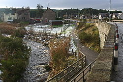
The present small, growing village of Cromdale lies on either side of where the A95 road crosses Cromdale Burn, between Grantown-on-Spey and Aberlour; this bridge[1] is about 500 metres south of the confluence of the burn with the River Spey.

An old cheese press built into a wall opposite the Cromdale Outdoor Education Centre. The village was within Inverness-shire until 1869 following which it became part of the Morayshire until 1975, when the county was divided between the Highland and Grampian regions; it is now within the Highland Council Area. The village retained Morayshire as its official postal address for many years after the change in local government boundaries.
The parish church and cemetery are located beside the River Spey at the end of Kirk Road beside the bridge which is the latest of three which replaced the nearby ferry. The bridge was financed by local residents, having been obtained as a War Surplus item from the War Office and erected in 1922 at a cost of £ 6889 [2]. The remains of an older bridge can be seen a short distance upstream; this (much lighter) bridge was swept away in 1894, the 1922 bridge replaced one that collapsed in 1921.[3]
About half way along Kirk Road is Cromdale Station which closed in the 1960s but survives in private hands along with some preserved railway paraphernalia. It lies on the route of the now closed Great North of Scotland Railway line from Boat of Garten to Craigellachie.
To the South of Cromdale is Balmenach Distillery which was served by a branch line running from Cromdale Station that passed under the main road alongside Cromdale Burn. This distillery has had a chequered history in recent years but is again in production.
The old school had become the Cromdale Outdoor Education Centre and stands opposite the Haugh Hotel.
The Battle of Cromdale took place in 1690 on the Haughs of Cromdale, about 2 miles East of the village.
The village is within the boundary of the Cairngorms National Park.
Football
Cromdale has a team which competes in the local Strathspey & Badenoch Welfare FA league: Cromdale FC. The club uses Cromdale's public football ground for all home matches.
Footnotes
- ^ Ordnance Survey grid reference for the bridge: NJ074284
- ^ Strathspey Herald, 19 Jan 1922 and 9 Feb 1922
- ^ Strathspey Herald, 19 Jan 1922
Traditional provinces and districts of Scotland Major districts (former counties, provincial lordships and rural deaneries) The Aird · Annandale · Angus · Argyll · Atholl · Boyne · Buchan · Badenoch · Breadalbane · Caithness · Carrick · Clydesdale (or Strathclyde) · Cowal · Cunningham · Desnes · Eskdale · Farines · Fife · Fothriff · Galloway · Garioch · Garmoran · The Glenkens · Gowrie · Kintyre · Knapdale · Kyle · Lauderdale · Lennox · Liddesdale · Lochaber · Lorn · Lothian · Mar · Mearns · Menteith · Merse · Moray · Nithsdale · The Rhinns · Ross (Easter and Wester) · Stormont · Strathavon · Strathbogie · Strathearn · Strathgryfe · Strathnaver · Strathspey · Sutherland · Teviotdale · Tweeddale
Minor districts Applecross · Appin · Ardgour · Ardmeanach · Ardnamurchan · Assynt · Avondale · Balquhidder · Benderloch · The Black Isle · Braemar · Coigach · Cromar · Cromdale · Douglasdale · Durness · Eddrachilles · Enzie · Ettrickdale · Ewesdale · Formartine · Gairloch · Glen Albyn · Glen Almond · Glen Cassley · Glen Clova · Glen Dochart · Glenelg · Glen Esk · Glengarry · Glen Lethnot · Glen Lyon · Glen Moriston · Glen Orchy · Glen Prosen · Glenshee · Glen Spean · Glen Urquhart · Gruinard · Howe of Fife · Howe of the Mearns · Kintail · Kintyre · Knoydart · Lochalsh · Loch Broom · Locheil · The Machars · Midmar · Moidart · Morar · Morven · Muir of Ord · Rannoch Moor · Rhinns of Kells · Strathallan · Strathardle · Strathbran · Strathbraan · Strathcarron (Forth) · Strathcarron (Oykel) · Strathconon · Strathdearn · Strathdeveron · Strathdee (Deeside) · Strathdon · Strathfarrar · Strath Gartney · Strathglass · Strathisla · Strathmore · Strath of Kildonan · Strath Oykel · Strath Tay · Strathyre · Sunart · Trossachs
Insular districts
For smaller islands, usually districts in their own right, see List of Scottish islandsBorder Areas Categories:- Populated places in Badenoch and Strathspey


Wikimedia Foundation. 2010.