- Lac Ste. Anne County, Alberta
Infobox Settlement
official_name = Lac Ste. Anne County
other_name =
native_name =
nickname =
settlement_type = County
motto =
imagesize =
image_caption =
flag_size =
image_
seal_size =
image_shield =
shield_size =
image_blank_emblem = Lac Ste Anne County sign.jpg
blank_emblem_size = 180px
mapsize =
map_caption =
mapsize1 =
map_caption1 =
image_dot_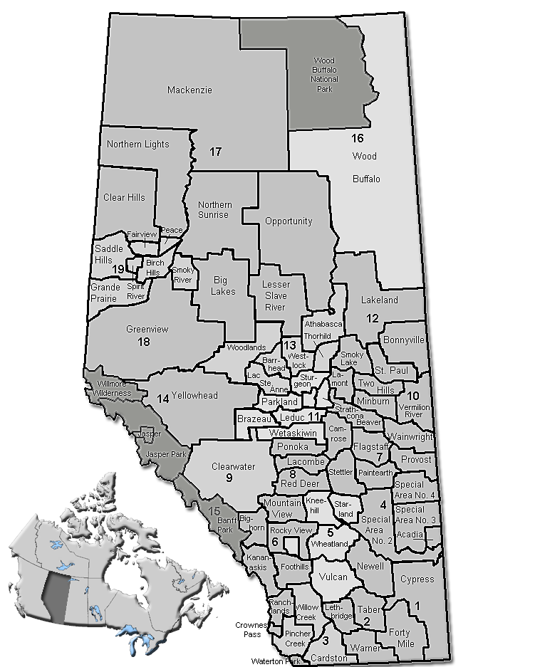
dot_mapsize = 225px
dot_map_caption = Location of Lac Ste. Anne County inAlberta
dot_x = 108 |dot_y = 155
pushpin_
pushpin_label_position =
pushpin_map_caption =
pushpin_mapsize =
subdivision_type = Country
subdivision_name = CAN
subdivision_type1 = Province
subdivision_name1 = AB
subdivision_type2 = Region
subdivision_name2 =Central Alberta
subdivision_type3 = Census division
subdivision_name3 = No. 13
subdivision_type4 =
subdivision_name4 =
government_footnotes =Cite web| url= http://www.gov.lacsteanne.ab.ca/index.php?option=com_content&task=view&id=1&Itemid=4| title= Council| author= Lac Ste. Anne County|accessdate= 2007-07-08]
government_type =
leader_title = Governing body
leader_name = Lac Ste. Anne County Council
leader_title1 = Reeve
leader_name1 = Derril C. Butler
leader_title2 = County seat
leader_name2 = Sangudo
leader_title3 =
leader_name3 =
leader_title4 =
leader_name4 =
established_title = Established
established_date = 1944
established_title2 = Incorporated
established_date2 = 1965
established_title3 =
established_date3 =
area_magnitude =
unit_pref =
area_footnotes =
area_total_km2 = 2842.46
area_land_km2 =
area_water_km2 =
area_total_sq_mi =
area_land_sq_mi =
area_water_sq_mi =
area_water_percent =
area_urban_km2 =
area_urban_sq_mi =
area_metro_km2 =
area_metro_sq_mi =
area_blank1_title =
area_blank1_km2 =
area_blank1_sq_mi =
population_as_of = 2006
population_footnotes =
population_note =
population_total = 9516
population_density_km2 = 3.3
population_density_sq_mi =
population_metro =
population_density_metro_km2 =
population_density_metro_sq_mi =
population_urban =
population_density_urban_km2 =
population_density_urban_sq_mi =
population_blank1_title = Dwellings
population_blank1 = 4567
population_density_blank1_km2 =
population_density_blank1_sq_mi =
timezone = MST
utc_offset = -7
timezone_DST =
utc_offset_DST =
latd= 53|latm= 53|lats= 42|latNS=N
longd= 114|longm= 53|longs= 27|longEW=W
elevation_footnotes =
elevation_m =
elevation_ft =
postal_code_type =
postal_code =
area_code =
blank_name =
blank_info =
blank1_name =
blank1_info =
website = [http://www.gov.lacsteanne.ab.ca/ Lac Ste. Anne County]
footnotes = Lac Ste. Anne County is amunicipal district in centralAlberta ,Canada .It is located in Census Division 13, north west of Edmonton. Highway 43 stretches across this county. The municipal seat is located in the Village of Sangudo.
The county was named after Lac Ste. Anne, which in turn was named for
Saint Anne .Demographics
In 2001, he municipal district had a population of 8,948 in 4,103 dwellings, a 2.4% increase from 1996. On a surface of 2,845.08 km² it had a density of 3.1 inhabitants/km². [ [http://www12.statcan.ca/english/Profil01/CP01/Details/Page.cfm?Lang=E&Geo1=CSD&Code1=4813001&Geo2=PR&Code2=48&Data=Count&SearchText=Lac%20Ste.%20Anne%20County&SearchType=Begins&SearchPR=01&B1=All&Custom= Lac Ste. Anne County community profile] - Statistics Canada. 2002. 2001 Community Profiles. Released June 27, 2002. Last modified: 2005-11-30. Statistics Canada Catalogue no. 93F0053XIE]
In 2006, Lac Ste. Anne County had a population of 9,516 living in 4,567 dwellings, a 6.3% increase from 2001. The municipal district has a land area of km2 to mi2|2842.46|abbr=yes|wiki=yes and a
population density of Pop density km2 to mi2|3.3| spell=UK | abbr=yes.Cite web| url= http://www12.statcan.ca/english/census06/data/profiles/community/Details/Page.cfm?Lang=E&Geo1=CSD&Code1=4813001&Geo2=PR&Code2=48&Data=Count&SearchText=Lac%20Ste.%20Anne%20County&SearchType=Begins&SearchPR=01&B1=All&GeoLevel=&GeoCode=4813001 | title= Lac Ste. Anne County - Community Profile | author= Statistics Canada| authorlink= Statistics Canada| year= Census 2006 | accessdate= 2007-06-11]Attractions
The municipality of Lac Ste. Anne maintains the "Lessard Lake Campground", the "Lessard Lake Outdoor Ed Centre" and the "George Pegg Botanic Garden". It also organizes the "Lac Ste. Anne Pilgrimage", a historic tradition that takes place at Lac Ste. Anne, dating back at the times of
Father Albert Lacombe .Many summer villages are established, especially on lake shores (such as Lac Ste. Anne,
Lac La Nonne , Birch Lake, Majeau Lake, Oldman Lake, Lessard Lake and Brock Lake).Protected and recreational areas in the county include "Lily Lake Provincial Natural Area", "Pembina River Provincial Natural Area", "Majeau Lake Provincial Natural Area" (with two campgrounds), "Paddle River Dam" Picnic Site, "Park Court Provincial Natural Area", "Lily Lake Provincial Natural Area" and "Prefontaine and Brock Lake Provincial Natural Area".
Communities
The following communities are located in this municipal district [Cite web|url=http://www.municipalaffairs.gov.ab.ca/cfml/profiles/data/0193_1.htm|title=Lac Ste. Anne Municipal Profile|author=Alberta Municipal Affairs|accessdate=2008-04-16] :Towns
*Mayerthorpe
*OnowayVillages
*Alberta Beach
*Sangudo (Municipal seat)Hamlets
*Cherhill
*Glenevis
*Green Court
*Gunn
*Rich Valley
*Rochfort BridgeSummer Villages
*Birch Cove
*Castle Island
*Nakamun Park
*Ross Haven
*Ross Haven
*Silver Sands
*South View
*Sunrise Beach
*Sunset Point
*Val Quentin
*West Cove
*YellowstoneReferences
External links
* [http://www.gov.lacsteanne.ab.ca/ Lac Ste. Anne County] (Official site)
Canadian City Geographic Location (8-way)
Northwest = Woodlands County
North = Barrhead County
Northeast = Barrhead County
West = Woodlands County
Centre = Lac Ste. Anne County
East =

Wikimedia Foundation. 2010.