- Akhalgori
Geobox Settlement
name = Akhalgori
native_name = ახალგორი
other_name = Leningor
other_name1 =
category = Town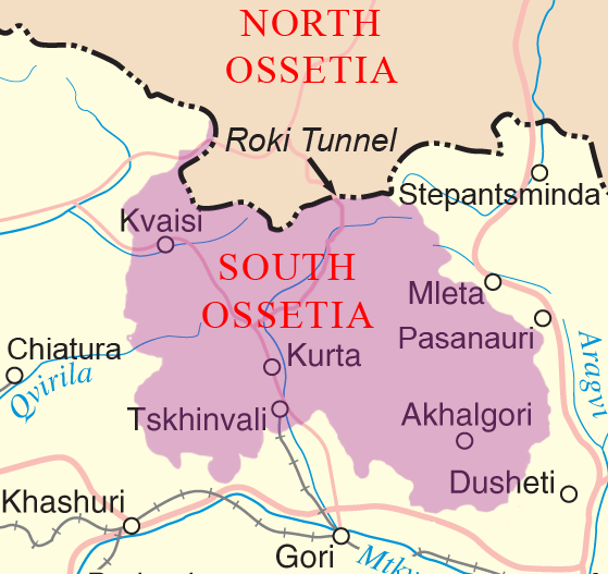
map_size = 280
map_caption = Location of Akhalgori/Leningor
map_locator =
map_locator_x = 76
map_locator_y = 72
flag_size =
symbol =
symbol_size =
etymology = "new Gori" from Georgian. (Leningor named after Vladimir Lenin)
nickname =
motto =
country =South Ossetia ["De facto " independent partially recognized] /Georgia [Recognised by most UN countries as part of Georgia.]
state =
region =
district =Akhalgori district /Leningor district
part_type =
part_count =
part =
part1 =
area = 10
location =
lat_d = 42
lat_m = 06
lat_s = 08
lat_NS = N
long_d = 44
long_m = 29
long_s = 11
long_EW = E
elevation = 788
population_as_of =
population = 2000
population_density =
established_type =
established =
mayor =
timezone =Moscow time
utc_offset = +3
timezone_DST = Moscow summer time
utc_offset_DST = +4
postal_code =
postal_code_type =
area_code =
area_code_type =
code2_type =
code2 =
free_type =
free =
free1_type =
free1 =
website =
.jpg)
image_size =
image_caption =Akhalgori ( _ka. ახალგორი) or Leningor ( _ru. Ленингор) is a town in
South Ossetia , "de facto " independent partially recognized republic in theSouth Caucasus , formerly theSouth Ossetian Autonomous Oblast within theGeorgian Soviet Socialist Republic .The town is located in eastern
South Ossetia on theKsani river .Town's position in administrative subdivision makeup
* According to
South Ossetia n official division, the town is the capital ofLeningor district of South OssetiaFact|date=October 2008
* According to Georgian official division, the town is in the region inMtskheta-Mtianeti ,Akhalgori district , of GeorgiaFact|date=October 2008Control over the town
The town remained under Georgian jurisdiction after most of South Ossetia broke away from the central government's control during the
1991–1992 South Ossetia War . It came under the control of South Ossetian secessionist authorities as a result of the2008 South Ossetia War [Civil.ge , [http://www.civil.ge/eng/article.php?id=19290 Sides Warn of ‘Tensions’ in Akhalgori] , 25.08.2008] on17 August . [ [http://www.lenta.ru/news/2008/08/25/village/ Осетины заявили о захвате грузинами села в непризнанной республике] onLenta.ru ] .Before the conflict, Akhalgori district had a population of 7,700, with approximately 2,000 living in the town itself. The largest villages were Ikorta, Korinta, Qanchaveti, Kvemo Zakhori, Largvisi, Doretkari, and Karchokhi. The population was primarily Georgian (6,520) and Ossetian (1,110) with good relations between the two communities.Fact|date=October 2008
Industry and commerce
Akhalgori is home to the Lomisi brewery, which is the primary employer of the town.
References
External links
* [http://www.leningorr.narod.ru/ Official Ossetian site of the town]
* [http://www.akhalgori.com/ Official Georgian site of the town]
Wikimedia Foundation. 2010.