Cowbridge Road West

Cowbridge Road West
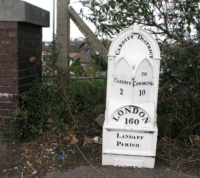
The Grade II listed mile marker at Ely Bridge on Cowbridge Road West near where it joins Cowbridge Road East and Western Avenue

Cowbridge Road West (Welsh: Heol y Bontfaen Gorllewin) is a major road in western Cardiff, the capital of Wales and forms part of the A48 road.

Ely Fire Station on Cowbridge Road West

It divides the districts of Ely and Caerau and connects inner Cardiff to Culverhouse Cross and eventually the M4 motorway via the A4232.

It also connects Cardiff ultimately to towns and villages such as Barry, Wenvoe, Cowbridge and Peterston-Super-Ely which can be accessed via the A48 from Culverhouse Cross.

Coordinates: 51°28′36″N 3°14′47″W / 51.4766°N 3.2463°W / 51.4766; -3.2463


Wikimedia Foundation. 2010.

Игры ⚽ Нужен реферат?

Look at other dictionaries:

  • Cowbridge Road East — shops …   Wikipedia

  • A4232 road — UK road routebox caption= road= A4232 length mi= 12.2 length km= 19.63 direction= Semi circular (West – East) start= M4 junction 33 destinations= Cardiff end= M4 junction 30 construction date=1978 completion date=1995 (unfinished) junctions=… …   Wikipedia

  • A4050 road — UK road routebox caption= The A4050 at Wenvoe road= A4050 length mi= 10 length km= direction= North South start= Culverhouse Cross destinations= Cardiff end= Barry construction date= completion date= junctions= ukroadsmall|48 ukroadsmall|4232… …   Wikipedia

  • Cowbridge — Coordinates: 51°27′38″N 3°26′53″W / 51.4605°N 3.4480°W / 51.4605; 3.4480 …   Wikipedia

  • A4161 road — UK road routebox road= A4161 length mi= length km= direction= East West start= A4232 (Southern Way) destinations= Cardiff end= A48 (Ely Bridge) construction date= completion date= junctions= ukroadsmall|4232 ukroadsmall|469 ukroadsmall|4160… …   Wikipedia

  • A473 road — Major junctions Northeast end: Upper Boat   …   Wikipedia

  • A48 road — UK road routebox road=A48 caption=The A48 (Eastern Avenue, Cardiff) length mi= length km= direction=East West start= Highnam destinations=Chepstow Newport Cardiff Bridgend Port Talbot Neath Swansea end= Carmarthen construction date= completion… …   Wikipedia

  • A4119 road — Route information Length: 19.5 mi (31.4 km) History: Construction completed 1995 …   Wikipedia

  • Ely, Cardiff — Ely (Welsh Trelai tref town + Elai River Ely) is a suburb primarily dominated by council housing in western Cardiff, Wales. Ely is believed to be the largest council estate area in Europe Fact|date=April 2008.HistoryIn Roman times, Ely was the… …   Wikipedia

  • Caerau, Cardiff — Caerau is a district of west Cardiff, capital city of Wales. Caerau Lane is the main road or avenue which is very much lined with large trees and shrubbery. Dominated mostly by council housing, it has the Western Leisure Centre, supermarkets,… …   Wikipedia

Share the article and excerpts

Direct link
Do a right-click on the link above
and select “Copy Link”