- Platanos, Aetolia-Acarnania
-
Platanos
ΠλάτανοςLocation 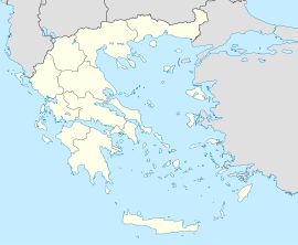
 Platanos
Coordinates 38°36′N 21°47′E / 38.6°N 21.783°ECoordinates: 38°36′N 21°47′E / 38.6°N 21.783°E Location within the peripheral unit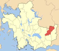
Government Country: Greece Region: West Greece Regional unit: Aetolia-Acarnania Municipality: Nafpaktia Population statistics (as of 2001) Municipal unit - Population: 1,775 Other Time zone: EET/EEST (UTC+2/3) Elevation (center): 832 m (2,730 ft) Postal: 300 22 Telephone: 26340 Auto: ME Platanos (Greek: Πλάτανος meaning maple) is a village and a former municipality in Aetolia-Acarnania, West Greece, Greece. Since the 2011 local government reform it is part of the municipality Nafpaktia, of which it is a municipal unit.[1] Population 1,775 (2001). The village population was 324 in 2001 and the municipal district was 404. It is linked with the road linking to Nafpaktos and the new dam as well as a mountain road to the north. Platanos is located in the mountainous region and are surrounded by forested mountains. The Evinos River is situated east of the town.
Contents
Subdivisions
The municipal unit Platanos is subdivided into the following communities (constituent villages in brackets):
- Platanos (Platanos, Kato Platanos)
- Agios Dimitrios
- Arachova (Arachova, Kranes)
- Achladokastro
- Dendrochori (uninhabited)
- Kastanea
- Klepa
- Livadaki
- Neochori Nafpaktias (Neochori, Petroto)
- Perdikovrysi
- Perista
- Chomori (Chomori, Agia Triada)
Historical population
Year Village Municipal district Municipality 1981 - 358 1991 227 - 1,694 2001 324 404 1,775 Other
Platanos has schools, lyceums or middle schools, a few gymnasia or secondary schools, churches, a post office, banks, and a few squares (plateies).
References
- ^ Kallikratis law Greece Ministry of Interior (Greek)
External links
- Municipality of Platanos (Greek)
- Platanos (municipality) on GTP Travel Pages (in English and Greek)
- Platanos (village) on GTP Travel Pages (in English and Greek)
- Oiniades on culture.gr
- Chomori Village (municipality of Platanos) (in English and Greek)
Municipal unit of Antirrio Municipal unit of Apodotia Ano Chora · Ampelakiotissa · Anavryti · Aspria · Elatovrysi · Elatou · Grammeni Oxya · Grigori · Kalloni · Katafygio · Kato Chora · Kentriki · Kokkinochori · Kryoneria · Kydonea · Lefka · Limnitsa · Mandrini · Podos · TerpsitheaMunicipal unit of Chalkeia Ano Vasiliki · Gavrolimni · Galatas · Kalavrouza · Perithori · Trikorfo · VasilikiMunicipal unit of Naupactus Municipal unit of Platanos Achladokastro · Agios Dimitrios · Arachova · Chomori · Dendrochori · Kastanea · Klepa · Livadaki · Neochori · Perdikovrysi · Perista · PlatanosMunicipal unit of Pyllini Anthofyto · Dorvitsia · Eleftheriani · Famila · Gavros · Milea · Palaiopyrgos · Pokista · Simos · Stranoma · StyliaCategories:- Populated places in Aetolia-Acarnania


Wikimedia Foundation. 2010.