- Cloud
-
For other uses, see Cloud (disambiguation).
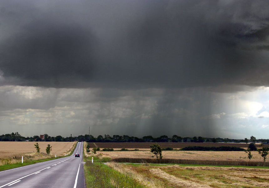
 Cumulus cloudscape over Swifts Creek, Australia
A cloud is a visible mass of liquid droplets or frozen crystals made of water and/or various chemicals suspended in the atmosphere above the surface of a planetary body. They are also known as aerosols. Clouds in Earth's atmosphere are studied in the nephology or cloud physics branch of meteorology. Two processes, possibly acting together, can lead to air's becoming saturated: cooling the air or adding water vapor to the air. In general, precipitation will fall to the surface; an exception is virga, which evaporates before reaching the surface.
Clouds can show convective development like cumulus, appear in layered sheets such as stratus, or take the form of thin fibrous wisps, as in the case of cirrus. Prefixes are used in connection with clouds: strato for low cumuliform-category clouds that show some stratiform characteristics, nimbo for thick stratiform clouds that can produce moderate to heavy precipitation, alto for middle clouds, and cirro for high clouds. Whether or not a cloud is low, middle, or high, level depends on how far above the ground its base forms.
Cloud types with significant vertical extent can form in the low or middle ranges depending on the moisture content of the air. Clouds in the troposphere have Latin names due to the popular adaptation of Luke Howard's cloud categorization system, which began to spread in popularity during December 1802. Synoptic surface weather observations use code numbers for the types of tropospheric cloud visible at each scheduled observation time based on the height and physical appearance of the clouds.
While a majority of clouds form in Earth's troposphere, there are occasions where clouds in the stratosphere and mesosphere are observed. Clouds have been observed on other planets and moons within the Solar System, but, due to their different temperature characteristics, they are composed of other substances such as methane, ammonia, and sulfuric acid.
Part of the Nature series on
WeatherCalendar seasons Spring · Summer
Tropical seasonsStorms Thunderstorm · Supercell
Downburst · Lightning
Tornado · Waterspout
Tropical cyclone (Hurricane)
Extratropical cyclone
Winter storm · Blizzard · Ice storm
Dust storm · Firestorm · CloudPrecipitation Drizzle · Rain · Snow · Graupel
Freezing rain · Ice pellets · HailTopics Meteorology · Climate
Weather forecasting
Heat wave · Air pollutionWeather portal Latin tropospheric nomenclature: historical background
 Altocumulus lenticularis forming over mountains in Wyoming with lower layer of cumulus mediocris and higher layer of cirrus spissatus.
Luke Howard, a methodical observer with a strong grounding in the Latin language, used his background to categorize the various tropospheric cloud types and forms during December 1802. He believed that the changing cloud forms in the sky could unlock the key to weather forecasting. Jean-Baptiste Lamarck worked independently on cloud categorization and came up with a different naming scheme that failed to make an impression even in his home country of France because it used unusual French names for cloud types. Howard used universally accepted Latin, which caught on quickly. As a sign of the popularity of the naming scheme, the German dramatist and poet Johann Wolfgang von Goethe composed four poems about clouds, dedicating them to Howard. Classification systems would be proposed by Heinrich Dove of Germany in 1828 and Elias Loomis of the United States in 1841, but neither became the international standard that Howard's system became. It was formally adopted by the International Meteorological Commission in 1929.[1]
Howard's original system established three general cloud categories based on physical appearance and process of formation: cirriform (mainly detached and wispy), cumuliform or convective (mostly detached and heaped, rolled, or rippled), and stratiform (mainly continuous layers in sheets). These were cross-classified into lower and upper families. Cumuliform clouds forming in the lower level were given the genus name cumulus, and low stratiform clouds the genus name stratus. Physically similar clouds forming in the upper height range were given the genus names cirrocumulus and cirrostratus, respectively. Cirriform category clouds were identified as always upper level and given the genus name cirrus. To these, Howard added the genus Nimbus for all clouds producing significant precipitation.[2]
Around 1840-41, German meteorologist Ludwig Kaemtz added stratocumulus as a mostly detached low-cloud genus with both cumuliform and stratiform characteristics, similar to upper level cirrocumulus. About fifteen years later, Emilien Renou, director of the Parc Saint-Maur and Montsouris observatories, began work on an elaboration of Howard's classifications that would lead to the introduction of altocumulus (physically more closely related to stratocumulus than to cumulus) and altostratus during the 1870s. These were cumuliform and stratiform cloud genera, respectively, of a newly defined middle height range above stratocumulus and stratus but below cirrocumulus and cirrostratus, with cumulus and nimbus occupying more than one altitude range as clouds with vertical extent. In 1880, Philip Weilbach, secretary and librarian at the Art Academy in Copenhagen, and like Luke Howard, an amateur meteorologist, proposed and had accepted by the International Meteorological Committee (IMC) the designation of a new vertical genus type, cumulonimbus, which would be distinct from cumulus and nimbus and identifiable by its appearance and ability to produce thunder. With this addition, a canon of ten cloud genera was established that came to be officially and universally accepted. At about the same time, several cloud specialists proposed variations that came to be accepted as species subdivisions and varieties determined by more specific variable aspects of the structure of each genus. One further modification of the genus classification system came when an IMC commission for the study of clouds put forward a refined and more restricted definition of the genus Nimbus renamed Nimbostratus.[2]
Formation: How the air becomes saturated
Cooling air to its dew point
In general, clouds will form when rising air is cooled to its dew point, the temperature at which the air becomes saturated.[3] Water vapour normally begins to condense on condensation nuclei such as dust, ice, and salt in order to form clouds. Condensation at surface level results in the formation of fog. If sufficient condensation particles are not present, the air will become supersaturated and the formation of cloud or fog will be inhibited. There are four main mechanisms for cooling the air to its dew point: adiabatic cooling, which tends to produce cloud, and conductive, radiational, and evaporative cooling, which can result in the formation of fog. Adiabatic cooling occurs when air rises and expands.[4] The air can rise due to convection, large-scale atmospheric lift along weather fronts and around centres of low pressure, or as a result of being forced over a physical barrier such as a mountain (orographic lift).[5] Conductive cooling occurs when the air comes into contact with a colder surface,[6] usually by being blown from one surface to another, for example from a liquid water surface to colder land. Radiational cooling occurs due to the emission of infrared radiation, either by the air or by the surface underneath.[7] Evaporative cooling occurs when moisture is added to the air through evaporation, which forces the air temperature to cool to its wet-bulb temperature, or until it reaches saturation.[8]
Adding moisture to the air
The main ways water vapour is added to the air are: wind convergence over water or moist ground into areas of upward motion,[9] precipitation or virga falling from above,[10] daytime heating evaporating water from the surface of oceans, water bodies or wet land,[11] transpiration from plants,[12] and cool or dry air moving over warmer water,[13]
Tropospheric classification
-

Low cloud weather map symbols
-
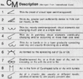
Middle cloud weather map symbols
-

High cloud weather map symbols
Physical categories
As established by Howard, cloud types or genera are grouped into three physical categories: cirriform, cumuliform or convective, and stratiform. These designations distinguish a cloud's physical structure and process of formation. All weather-related clouds form in the troposphere, the lowest major layer of the Earth's atmosphere.[14]
 Vertical family D2 Cumulonimbus capillatus with anvil-shaped incus supplementary feature. Higher layer of family A cirrus spissatus near top of image.
Cumuliform-category clouds are the product of localized convective or orographic lift.[14] If the airmass is only slightly unstable, clouds of limited convection that show both cumuliform and stratiform characteristics will form. If a poorly organized weather system is present, weak intermittent precipitation may fall from these clouds. With greater airmass instability caused by a steeper temperature gradient from warm or hot at surface level to cold aloft, clouds of free convection will form and rise to greater heights, especially if associated with fast-moving unstable cold fronts. Large free-convective clouds can produce light to moderate showers if the airmass is sufficiently moist. The largest free-convective cumuliform types produce thunderstorms and a variety of types of lightning including cloud-to-ground that can cause wildfires.[15] Other convective severe weather may or may not be associated with thunderstorms and include heavy rain or snow showers, hail,[16] strong wind shear, downbursts,[17] and tornadoes.[18]
In general, stratiform-category clouds form as the result of non-convective lift of relatively stable air, especially along slow-moving warm fronts, around areas of low pressure, and sometimes along stable slow moving cold fronts.[14] In general, precipitation is steady and widespread, with intensity varying from light to heavy according to the thickness of the stratiform layer as determined by moisture content of the air and the intensity of the weather system creating the clouds and weather. Low stratiform clouds can also form in precipitation below the main frontal cloud deck where the colder air is trapped under the warmer airmass being forced above by the front. Non-frontal low stratiform cloud can form when advection fog is lifted above surface level during breezy conditions.[19]
Cirriform-category clouds form mostly at high altitudes along the very leading edges of a frontal and/or low-pressure weather disturbance and often along the fringes of its other borders. In general, they are non-convective but occasionally acquire a tufted or turreted appearance caused by small scale high-altitude convection. These high clouds do not produce precipitation as such but can merge and thicken into lower stratiform layers that do.[20]
Families and cross-classification into genera
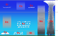 Cloud classification by altitude of occurrence
The individual genus types result from the physical categories being cross-classified by height range family within the troposphere. These include family A (high), family B (middle), family C (low), family D1 (moderate vertical with low to middle bases), and family D2 (towering vertical with low to middle bases). The family designation for a particular genus is determined by the base height of the cloud and its vertical extent. The base height range for each family varies depending on the latitudinal geographical zone.[21]
Families A and B: All Cirriform-category clouds are classified as high range family A and thus constitute a single genus cirrus (Ci). Cumuliform and stratiform-category clouds in the high-altitude family carry the prefix cirro, yielding the respective genus names cirrocumulus (Cc) and cirrostratus (Cs). Similar genera in the middle-range family B are prefixed by alto, yielding the genus names altocumulus (Ac) and altostratus (As).[14]
Families C and D1: Any cumuliform or stratiform genus in these two families either has no prefix or carries one that refers to a characteristic other than altitude. The two non-prefixed genera are non-convective low stratus (St: family C),and free-convective moderate vertical cumulus (Cu: family D1). One prefixed cloud in this group is stratocumulus (Sc), a limited convection genus of the low-altitude family C that has some stratiform characteristics (as do the middle- and high-based genera altocumulus and cirrocumulus, the genus names of which exclude strato to avoid double-prefixing). The other prefixed cloud is nimbostratus (Ns), a non-convective genus of the moderate vertical family D1 that has some vertical extent and whose prefix refers to its ability to produce significant precipitation.[22]
Family D2: This family comprises large towering free-convective clouds that typically occupy all altitude ranges and, therefore, also carry no height related prefixes. They comprise the genus cumulonimbus (Cb) and the cumulus species cumulus congestus (Cu con), which is also known informally as towering cumulus (Tcu). Under conditions of very low humidity, free-convective clouds may form above the low-altitude range and, therefore, be found only at middle- and high-tropospheric altitudes. In the modern system of cloud nomenclature, cumulonimbus is something of an anomaly. The cumuliform-category designation appears in the prefix rather than the root, which refers instead to the cloud's ability to produce storms and heavy precipitation. This apparent reversal of prefix and root is a carry-over from the nineteenth century, when nimbus was the root word for all precipitating clouds.[20]
Major precipitation clouds: Although they do not comprise a family as such, cloud genera with nimbo or nimbus in their names are the principal bearers of precipitation. Although nimbostratus initially forms in the middle height range, it can be classified as moderate vertical because it achieves considerable thickness despite not being a convective cloud like cumulonimbus, the other main precipitating cloud genus. Frontal lift can push the top of a nimbostratus deck into the high-altitude range while precipitation drags the base down to low altitudes.[23] The World Meteorological Organization (WMO) classifies nimbostratus as a middle cloud whose base typically thickens down into the low altitude range during precipitation.[24]
Species
 Natural beauty of cumulus fractus clouds in Nepali sky
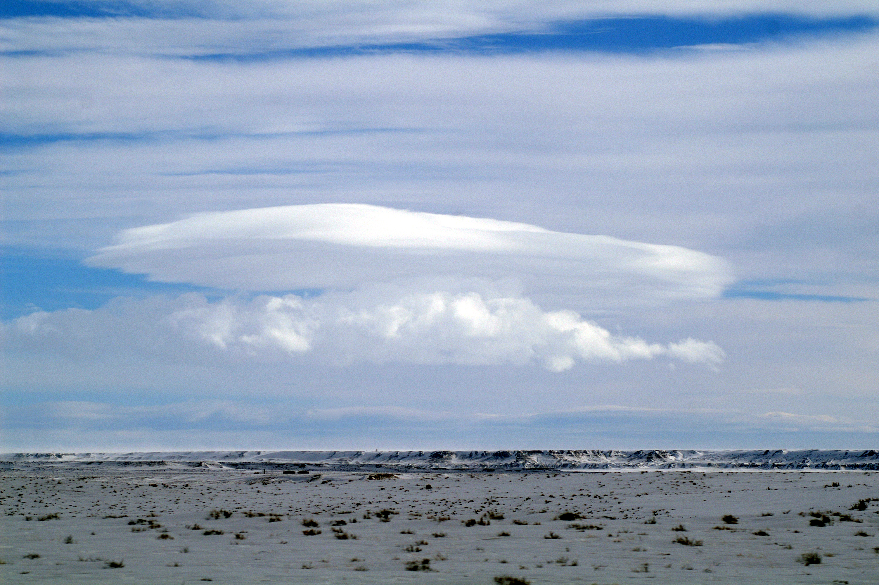
Genus types are subdivided into species that indicate specific structural details. However, because these latter types are not always restricted by height range, some species can be common to several genera that are differentiated mainly by altitude. The best examples of these are the species stratiformis, lenticularis, and castellanus, which are common to cumuliform genera of limited convection in the high-, middle-, and low-height ranges (cirrocumulus, altocumulus, and stratocumulus, respectively). Stratiformis species normally occur in extensive sheets or in smaller patches with only minimal convective activity. Lenticularis species tend to have lens-like shapes tapered at the ends. They are most commonly seen as orographic mountain-wave clouds, but can occur anywhere in the troposphere where there is strong wind shear. Castellanus structures, which resemble the turrets of a castle when viewed from the side, can also be found in convective patches of cirrus, as can the more detached tufted floccus species, which are common to cirrus, cirrocumulus, and altocumulus. However, floccus is not associated with stratocumulus in the lower levels where local airmass instability tends to produce clouds of the more freely convective cumulus and cumulonimbus genera whose species are mainly indicators of degrees of vertical development.[24]
Cirrus clouds have several additional species unique to the wispy structures of this genus, which include uncinus, filaments with upturned hooks, and spissatus, filaments that merge into dense patches. One exception is the species fibratus, which also occurs with cirrostratus that is transitional to or from cirrus. Cirrostratus at its most characteristic tends to be mostly of the species nebulosus, which creates a rather diffuse appearance lacking in structural detail. All altostratus and nimbostratus clouds share this physical appearance without significant variation or deviation and, therefore, do not need to be subdivided into species. Low continuous stratus is also of the species nebulosus except when broken up into ragged sheets of stratus fractus. This latter fractus species also occurs with ragged cumulus.[24]
Varieties
Genus and species types are further subdivided into varieties; some of which are determined by the opacities of particular low and middle cloud structures (translucidus, opacus, and perlucidus; the last of which is opaque with translucent breaks). By implication rather than formal designation, all family A high clouds are 'translucidus'. On the converse, all clouds with at least some significant vertical extent, including moderate vertical family D1 nimbostratus and cumulus, are 'opacus', as are the towering vertical family D2 clouds, cumulonimbus and cumulus congestus.[24]
Other varieties are determined by the arrangements of the cloud structures into particular patterns that are discernable by a surface-based observer (cloud fields usually being visible only from a significant altitude above the formations). The variety undulatus (having a wavy undulating base) is common to all high, middle, and low genera except those with significant vertical extent. Another common variety, duplicatus (closely spaced layers of the same genus, one above the other), is found with all the same genera except cirrocumulus. The variety radiatus is associated with cloud rows of a particular genus that appear to converge at the horizon and is seen mostly with cirrus, altocumulus, altostratus, stratocumulus, and cumulus.[24]
Intortus and vertebratus varieties occur only with the genus cirrus and are, respectively, filaments twisted into irregular shapes and those that are arranged in fishbone patterns. Probably the most uncommonly seen is the variety lacunosus, caused by localized downdrafts that punch circular holes into high, middle, and/or low cumuliform cloud layers of limited convection.[24]
Supplementary features
 Clouds made orange by the sun rising
One group of supplementary features are not actual cloud formations but precipitation that falls when water droplets that make up visible clouds have grown too heavy to remain aloft. Virga is a feature seen with clouds producing precipitation that evaporates before reaching the ground, these being of the genera cirrocumulus, altocumulus, altostratus, nimbostratus, stratocumulus, cumulus, and cumulonimbus. When the precipitation reaches the ground without completely evaporating, it is designated as the feature praecipitatio. This normally occurs with family B altostratus opacus, which can produce widespread but usually light precipitation, and with clouds of the thicker moderate vertical family D1. Of the latter family, cumulus mediocris produces only isolated light showers, while nimbostratus is capable of heavier more extensive precipitation. Towering vertical clouds of the family D2 have the greatest ability to produce intense precipitation events, but these tend to be localized unless organized along fast-moving cold fronts. Showers of moderate to heavy intensity can fall from cumulus congestus clouds. Cumulonimbus, the largest of all cloud genera, has the capacity to produce very heavy showers. Low stratus clouds usually produce only light precipitation, but this always occurs as the feature praecipitatio due to the fact this cloud genus lies too close to the ground to allow for the formation of virga. The heavier precipitating clouds, nimbostratus, towering cumulus (cumulus congestus), and cumulonimbus, also typically see the formation in precipitation of the pannus feature, low ragged clouds of the genera and species cumulus fractus and/or stratus fractus.[24]
 Clouds dot dusk
Another group of supplementary features comprises cloud formations that are associated mainly with cumuliform clouds of free convection. Pileus is a cap cloud that can form over a cumulonimbus or large cumulus cloud, whereas a velum feature is a thin horizontal sheet that sometime forms around the middle or in front of the parent cloud. A tuba feature is a cloud column that may hang from the bottom of a cumulus or cumulonimbus. An arcus feature is a roll or shelf cloud that forms along the leading edge of a squall line or thunderstorm outflow.[24] Some arcus clouds form as a consequence of interactions with specific geographical features. Perhaps the strangest geographically specific arcus cloud in the world is the Morning Glory, a rolling cylindrical cloud that appears unpredictably over the Gulf of Carpentaria in Northern Australia. Associated with a powerful "ripple" in the atmosphere, the cloud may be "surfed" in glider aircraft. Mamma (sometimes known informally as mammatus) form on the bases of clouds as downward-facing bubble-like protuberances caused by localized downdrafts within the cloud. The best-known is cumulonimbus with mammatus, but the mamma feature is also seen occasionally with cirrus, cirrocumulus, altocumulus, altostratus, and stratocumulus. Incus is the most type-specific supplementary feature, seen only with cumulonimbus of the species capillatus. A cumulonimbus incus cloud top is one that has spread out into a clear anvil shape as a result of rising air currents hitting the stability layer at the tropopause where the air no longer continues to get colder with increasing altitude.
Stratocumulus fields
Stratocumulus clouds can be organized into 'fields' that take on certain specially classified shapes and characteristics. In general, these fields are more discernable from high altitudes than from ground level. They can often be found in the following forms:
- Actinoform, which resembles a leaf or a spoked wheel.
- Closed cell, which is cloudy in the center and clear on the edges, similar to a filled honeycomb.
- Open cell, which resembles a honeycomb, with clouds around the edges and clear, open space in the middle.[25]
Summary of families, genera, species, and associated weather
High (Family A)
 High family A cirrus uncinus and cirrus fibratus upper-left merging into cirrostratus fibratus with some higher cirrocumulus floccus upper right.
High clouds form between 10,000 and 25,000 ft (3,000 and 8,000 m) in the polar regions, 16,500 and 40,000 ft (5,000 and 12,000 m) in the temperate regions and 20,000 and 60,000 ft (6,000 and 18,000 m) in the tropical region. It is the only height range family that includes genera from all three physical categories.[21]
Family A includes:
- Genus Cirrus (Ci): Fibrous wisps of delicate white ice crystal cloud that show up clearly against the blue sky.
Cirrus clouds are generally non-convective except castellanus and floccus species. They often form along a high altitude jetstream and at the very leading edge of a frontal or low pressure disturbance where they may merge into cirrostratus.
-
- Species Cirrus fibratus (Ci fib): Fibrous cirrus with no tufts or hooks.
- Species Cirrus uncinus (Ci unc): Hooked cirrus filaments.
- Species Cirrus spissatus (Ci spi): Patchy dense cirrus.
- Species Cirrus castellanus (Ci cas): Partly turreted cirrus.
- Species Cirrus floccus (Ci flo): Partly tufted cirrus.
- Genus Cirrocumulus (Cc): A cloud layer of limited convection composed of ice crystals and/or supercooled water droplets appearing as small white rounded masses or flakes in groups or lines with ripples like sand on a beach. They occasionally form alongside cirrus and/or cirrostratus clouds at the very leading edge of an active weather system.
- Species Cirrocumulus stratiformis (Cc str): Sheets or relatively flat patches of cirrocumulus.
- Species Cirrocumulus lenticularis (Cc len): Lens-shaped cirrocumulus.
- Species Cirrocumulus castellanus (Cc cas): Turreted cirrocumulus.
- Species Cirrocumulus floccus (Cc flo): Tufted cirrocumulus.
- Genus Cirrostratus (Cs): A thin non-convective ice crystal veil that typically gives rise to halos caused by refraction of the sun's rays. The sun and moon are visible in clear outline. Cirrostratus typically thickens into altostratus ahead of a warm front or low-pressure area.
- Species Cirrostratus fibratus (Cs fib): Fibrous cirrostratus less detached than cirrus.
- Species Cirrostratus nebulosus (Cs neb): A featureless veil of cirrostratus.[24]
Middle (Family B)
 Family B middle clouds over Santa Clarita, CA. Altocumulus floccus producing virga near top and middle of image merging into altostratus near horizon.
Middle clouds tend to form at 6,500 ft (2,000 m) but may form at heights up to 13,000 ft (4,000 m), 23,000 ft (7,000 m) or 25,000 ft (8,000 m) depending on the latitudinal region. In general, the warmer the climate the higher the cloud base. Family B usually comprises one cumuliform and one stratiform-category genus.[26]
Family B includes:
- Genus Altocumulus (Ac): A cloud layer of limited convection usually in the form of irregular patches or rounded masses in groups, lines, or waves. High altocumulus may resemble cirrocumulus but is usually thicker and composed of water droplets so that the bases show at least some light-grey shading. Opaque altocumulus associated with a weak frontal or low-pressure disturbance can produce very light intermittent precipitation.
- Species Altocumulus stratiformis (Ac str): Sheets or relatively flat patches of altocumulus.
- Species Altocumulus lenticularis (Ac len): Lens-shaped altocumulus.
- Species Altocumulus castellanus (Ac cas): Turreted altocumulus.
- Species Altocumulus floccus (Ac flo): Tufted altocumulus.
- Genus Altostratus (As): An opaque or translucent non-convective veil of grey/blue-grey cloud that often forms along warm fronts and around low-pressure areas where it may thicken into nimbostratus. Altostratus is usually composed of water droplets but may be mixed with ice crystals at higher altitudes. Widespread opaque altostratus can produce light continuous or intermittent precipitation.
- Altostratus is not subdivided into species.[24]
Low (Family C)
 Low family C stratocumulus stratiformis clouds mainly in foreground with moderate vertical family D1 cumulus humilis and cumulus mediocris in the foreground and background
Low clouds are found from near surface up to 6,500 ft (2,000 m).[21] Family C also typically includes one cumuliform and one stratiform-category genus.[26] When low stratiform clouds contact the ground, they are called fog, although radiation and advection types of fog do not form from stratus layers.
Family C includes:
- Genus Stratocumulus (Sc): A cloud layer of limited convection usually in the form of irregular patches or rounded masses similar to altocumulus but having larger elements with deeper-gray shading. Opaque stratocumulus associated with a weak frontal or low-pressure distrubance can produce very light intermittent precipitation. This cloud often forms under a precipitating deck of altostratus or high-based nimbostratus associated with a well-developed warm front, slow-moving cold front, or low-pressure area. This can create the illusion of continuous precipitation of more than very light intensity falling from stratocumulus.
- Species Stratocumulus stratiformis (Sc str): Sheets or relatively flat patches of stratocumulus.
- Species Stratocumulus lenticularis (Sc len): Lens-shaped stratocumulus.
- Species Stratocumulus castellanus (Sc cas): Turreted stratocumulus.
- Genus Stratus (St): A uniform layer of non-convective cloud resembling fog but not resting on the ground.
- Species Stratus nebulosus (St neb): A featureless veil of stratus sometimes producing light drizzle.
- Species Stratus fractus (St fra): A ragged broken up sheet of stratus that often forms in precipitation falling from a higher cloud deck. This species may also result from a continuous sheet of stratus becoming broken up by the wind.[24]
Moderate vertical (Family D1)
 Moderate vertical family D1 nimbostratus cloud covering the sky with a scattered layer of low family C stratus fractus in the middle of the upper-half of the image.
Family D1 clouds have low to middle bases anywhere from near surface to about 10,000 ft (3,000 m) and, therefore, do not fit very well into the conventional height ranges of low, middle, and high. This group continues the pattern of comprising one cumuliform and one stratiform-category genus. Cumulus usually forms in the low-altitude range, but bases may rise into the lower part of the middle range during conditions of very low relative humidity. Nimbostratus normally forms from altostratus in the middle-altitude range and achieves vertical extent when the base subsides into the low range during precipitation.[27] Some methods of cloud-height classification reserve the term vertical for upward-growing free-convective cumuliform clouds.[28] Downward-growing nimbostratus is then classified as low or middle, even when it becomes very thick as a result of this process - which is often augmented by frontal lift causing non-convective upward growth as well. Some authorities do not use a vertical family designation at all, and therefore also include free-convective cumulus types with the family of low clouds.[21]
Family D1 includes:
- Genus Cumulus[29] (Cu): Clouds of free convection with clear-cut flat bases and domed tops. Towering cumulus (cumulus congestus) are usually classified as family D2 clouds of considerable vertical development.
- Species Cumulus fractus (Cu fra): Cumulus clouds broken up into ragged and changing fragments.
- Species Cumulus humilis (Cu hum): Small cumulus clouds usually with just a light-grey shading underneath.
- Species Cumulus mediocris (Cu med): Cumulus clouds of moderate size with medium-grey shading underneath. Cumulus mediocris can produce scattered showers of light intensity.
- Genus Nimbostratus (Ns): A diffuse dark-grey non-convective layer that looks feebly illuminated from the inside. It normally forms from altostratus along warm fronts and around low-pressure areas and produces widespread steady precipitation that can reach moderate or heavy intensity.
- Nimbostratus is not subdivided into species.[24]
Towering vertical (Family D2)
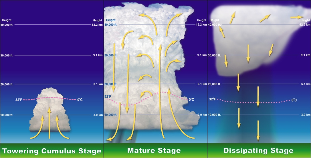
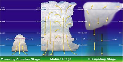 Stages of a cumulonimbus cloud's life.
These clouds can have strong vertical currents and rise far above bases, which form anywhere in the low to lower-middle altitude range from near surface to about 10,000 ft (3,000 m). Like smaller cumuliform clouds in family D1, these towering giants usually form in the low-altitude range at first, but the bases can rise into the middle range when the moisture content of the air is very low. Unlike families A through D1 that each include a cumuliform and stratiform-category genus, the family of towering clouds, instead, has one cumuliform-category genus and one species of cumulus, a genus otherwise considered a cloud of moderate vertical development. By definition, even very thick stratiform clouds cannot have towering vertical extent or structure, although they may be accompanied by embedded towering cumuliform types. As with the moderate vertical clouds, some authorities do not recognize a separate family of towering vertical types, and, instead, classify them as low family C. Others designate vertical clouds separately from low, middle, and high, but consider moderate and towering vertical types to be a single family. However, the International Civil Aviation Organization (ICAO) distinguishes towering vertical clouds by specifying that these very large family D2 cumuliform types must be identified by genus names or standard abbreviations in all aviation observations (METARS) and forecasts (TAFS) to warn pilots of possible severe weather and turbulance.[30]
Family D2 includes:
- Genus Cumulonimbus (Cb): Heavy towering masses of free convective cloud with dark-grey to nearly black bases that are associated with thunderstorms and showers. Thunderstorms can produce a range of severe weather that includes hail, tornadoes, a variety of other localized strong wind events, several types of lightning, and local very heavy downpours of rain that can cause flash floods, although lightning is the only one of these that requires a thunderstorm to be taking place. In general, cumulonimbus require moisture, an unstable air mass, and a lifting force (heat) in order to form. Cumulonimbus typically go through three stages: the developing stage, the mature stage, and the dissipation stage.[31] The average thunderstorm has a 24 km (15 mi) diameter. Depending on the conditions present in the atmosphere, these three stages take an average of 30 minutes to go through.[32]
- Species Cumulonimbus calvus (Cb cal): Cumulonimbus clouds with very high clear-cut domed tops similar to towering cumulus.
- Species Cumulonimbus capillatus (Cb cap): Cumulonimbus clouds with very high tops that have become fibrous due to the presence of ice crystals.
- Genus Cumulus (Cu)[33][34]
- Species Cumulus congestus (WMO: Cu Con/ICAO: TCu): Towering cumulus clouds of great vertical size, usually with dark-grey bases, and capable of producing severe turbulence and showers of moderate to heavy intensity.
- Pyrocumulus (No official abbreviation): Cumulus clouds associated with volcanic eruptions and large-scale fires. Pyrocumulus is not recognised by the WMO as a distinct genus or species, but is, in essence, cumulus congestus formed under special circumstances that can also cause severe turbulance.[35]
- Species Cumulus congestus (WMO: Cu Con/ICAO: TCu): Towering cumulus clouds of great vertical size, usually with dark-grey bases, and capable of producing severe turbulence and showers of moderate to heavy intensity.
Above the troposphere
A few relatively uncommon clouds can be found above the troposphere, where moisture is very scarce. These include polar mesospheric noctilucent clouds and nacreous polar stratospheric clouds. They are composed mostly of ice crystals and occur at high latitudes, mostly within 40 degrees of the poles[36] in the mesosphere and stratosphere, respectively. Most clouds above the troposphere have a wispy or fibrous appearance and can be mistakenly identified as high-tropospheric cirrus clouds.
Polar stratospheric
Nacreous clouds occur in the stratosphere most typically at altitudes of 15,000–25,000 m (50,000–80,000 ft) during the winter when that part of the atmosphere is coldest and has the best chance of triggering condensation. Also known as mother of pearl clouds, they are typically very thin with a cirriform appearance. Nacreous clouds are sub-classified alpha-numerically based on chemical makeup rather than variations in physical appearance.
- Type 1: Nacreous containing supercooled nitric acid and water droplets.
Subtypes
-
- 1A: Nacreous containing crystals of water and nitric acid.
- 1B: Also contains supercooled sulfuric acid in ternary solution.
- Type 2: Nacreous consisting of water crystals only.
Polar mesospheric
The polar air in the mesosphere is colder during the summer so it is mostly at this time of year that noctilucent clouds are seen.[37][38] They can occasionally be seen illuminated by the sun during deep twilight at ground level. Noctilucent clouds are the highest in the atmosphere and occur mostly at altitudes of 80 to 85 kilometers (50 to 53 mi),[39] in the mesosphere. An alpha-numeric sub-classification is used to identify variations in physical appearance.
- Type 1: Very tenuous noctilucent resembling cirrus fibratus.
- Type 2: Bands; noctilucent in the form of long streaks, often in groups or interwoven at small angles, similar to cirrus intortus.
Subtypes
-
- 2A: Noctilucent streaks with diffuse, blurred edges.
- 2B: Streaks with sharply defined edges.
- Type 3: Billows; noctilucent in the form of short streaks that are clearly spaced and roughly parallel.
Subtypes
-
- 3A: Noctilucent in the form of short, straight, narrow streaks.
- 3B: Wave-like streaks similar to cirrus undulatus.
- Type 4: Whirls; noctilucent in the form of partial or rarely complete rings with dark centers.
Subtypes
-
- 4A: Noctilucent whirls of small angular radius having a similar appearance to surface water ripples.
- 4B: Simple curve of medium angular radius with one or more bands.
- 4C: Whirls with large-scale ring structure.
Coloration
 An occurrence of altocumulus and cirrocumulus cloud iridescence
 Sunset reflecting shades of pink onto grey stratocumulus clouds.
The first recorded coloured cloud was seen by Nathan Ingleton in 1651, he wrote the event in his diary but the records were destroyed on 1666, in the Great Fire of London. The color of a cloud, as seen from Earth, tells much about what is going on inside the cloud. Dense, deep tropospheric clouds exhibit a high reflectance (70% to 95%) throughout the visible spectrum. Tiny particles of water are densely packed and sunlight cannot penetrate far into the cloud before it is reflected out, giving a cloud its characteristic white color, especially when viewed from the top.[40] Cloud droplets tend to scatter light efficiently, so that the intensity of the solar radiation decreases with depth into the gases. As a result, the cloud base can vary from a very light to very-dark-grey depending on the cloud's thickness and how much light is being reflected or transmitted back to the observer. Thin clouds may look white or appear to have acquired the color of their environment or background. High tropospheric and non-tropospheric clouds appear mostly white if composed entirely of ice crystals and/or supercooled water droplets.
As a tropospheric cloud matures, the dense water droplets may combine to produce larger droplets, which may combine to form droplets large enough to fall as rain. By this process of accumulation, the space between droplets becomes increasingly larger, permitting light to penetrate farther into the cloud. If the cloud is sufficiently large and the droplets within are spaced far enough apart, it may be that a percentage of the light that enters the cloud is not reflected back out before it is absorbed. A simple example of this is one's being able to see farther in heavy rain than in heavy fog. This process of reflection/absorption is what causes the range of cloud color from white to black.[41]
Other colors occur naturally in clouds. Bluish-grey is the result of light scattering within the cloud. In the visible spectrum, blue and green are at the short end of light's visible wavelengths, whereas red and yellow are at the long end. The short rays are more easily scattered by water droplets, and the long rays are more likely to be absorbed. The bluish color is evidence that such scattering is being produced by rain-size droplets in the cloud. A greenish tinge to a cloud is produced when sunlight is scattered by ice. A cumulonimbus cloud emitting green is a sign that it is a severe thunderstorm,[42] capable of heavy rain, hail, strong winds, and possible tornadoes. Yellowish clouds may occur in the late spring through early fall months during forest fire season. The yellow color is due to the presence of pollutants in the smoke. Yellowish clouds caused by the presence of nitrogen dioxide are sometimes seen in urban areas with high air pollution levels.[43]
Red, orange, and pink clouds occur almost entirely at sunrise/sunset and are the result of the scattering of sunlight by the atmosphere. When the angle between the sun and the horizon is less than 10 percent, as it is just after sunrise or just prior to sunset, sunlight becomes too red due to refraction for any colors other than those with a reddish hue to be seen.[42] The clouds do not become that color; they are reflecting long and unscattered rays of sunlight, which are predominant at those hours. The effect is much like if one were to shine a red spotlight on a white sheet. In combination with large, mature thunderheads, this can produce blood-red clouds. Clouds look darker in the near-infrared because water absorbs solar radiation at those wavelengths.
Effects on climate
See also: Cloud cover and Cloud feedbackThe role of clouds in regulating weather and climate remains a leading source of uncertainty in projections of global warming.[44] This uncertainty arises because of the delicate balance of processes related to clouds, spanning scales from millimeters to planetary. Hence, interactions between the large-scale (synoptic meteorology) and clouds becomes difficult to represent in global models. The complexity and diversity of clouds, as outlined above, adds to the problem. On the one hand, white-colored cloud tops promote cooling of Earth's surface by reflecting shortwave radiation from the Sun. Most of the sunlight that reaches the ground is absorbed, warming the surface, which emits radiation upward at longer, infrared, wavelengths. At these wavelengths, however, water in the clouds acts as an efficient absorber. The water reacts by radiating, also in the infrared, both upward and downward, and the downward radiation results in a net warming at the surface. This is analogous to the greenhouse effect of greenhouse gases and water vapor.
High clouds, such as cirrus, particularly show this duality with both shortwave albedo cooling and longwave greenhouse warming effects that nearly cancel or slightly favor net warming with increasing cloud cover. The shortwave effect is dominant with middle and low clouds like altocumulus and stratocumulus, which results in a net cooling with almost no longwave effect. As a consequence, much research has focused on the response of low clouds to a changing climate. Leading global models can produce quite different results, however, with some showing increasing low-level clouds and other showing decreases.[45][46]
Global brightening
New research indicates a global brightening trend.[47] The details are not fully understood, but much of the global dimming (and subsequent reversal) is thought to be a consequence of changes in aerosol loading in the atmosphere, especially sulfur-based aerosol associated with biomass burning and urban pollution. Changes in aerosol burden can have indirect effects on clouds by changing the droplet size distribution[48] or the lifetime and precipitation characteristics of clouds.[49]
Rainmaking bacteria
Bioprecipitation, the concept of rain-making bacteria, was proposed by David Sands from Montana State University. Such microbes - called ice nucleators - are found in rain, snow, and hail throughout the world. These bacteria may be part of a constant feedback between terrestrial ecosystems and clouds and may even have evolved the ability to promote rainstorms as a means of dispersal. They may rely on the rainfall to spread to new habitats, much as some plants rely on windblown pollen grains.[50][51]
Extraterrestrial
Main article: Extraterrestrial atmospheresWithin our Solar System, any planet or moon with an atmosphere also has clouds. Venus's thick clouds are composed of sulfur dioxide.[52] Mars has high, thin clouds of water ice. Both Jupiter and Saturn have an outer cloud deck composed of ammonia clouds, an intermediate deck of ammonium hydrosulfide clouds and an inner deck of water clouds.[53][54] Saturn's moon Titan has clouds believed to be composed largely of methane.[55] The Cassini–Huygens Saturn mission uncovered evidence of a fluid cycle on Titan, including lakes near the poles and fluvial channels on the surface of the moon. Uranus and Neptune have cloudy atmospheres dominated by water vapor and methane gas.[56][57]
See also
- Atmospheric Radiation Measurement (ARM) (in the US)
- Cloud albedo
- Cloud Appreciation Society
- Cloud forcing
- Cloud seeding
- Cloudscape (art)
- Cloudscape photography
- Coalescence
- Extraterrestrial skies
- Flight ceiling
- Fractus cloud
- List of cloud types
- Mist
- Mushroom cloud
- Pileus (meteorology)
- Undulatus asperatus
- Weather lore
- Cloud Computing
References
- ^ John D. Cox (2002). Storm Watchers. John Wiley & Sons, Inc.. pp. 13–17.
- ^ a b Office National Meteorologique (1932). International Atlas of Clouds and of States of the Sky. Paris. p. II.
- ^ Glossary of Meteorology (June 2000). "Dewpoint". American Meteorological Society. http://amsglossary.allenpress.com/glossary/search?id=dewpoint1. Retrieved 2011-01-31.
- ^ Glossary of Meteorology (June 2000). "Adiabatic Process". American Meteorological Society. http://amsglossary.allenpress.com/glossary/search?id=adiabatic-process1. Retrieved 2008-12-27.
- ^ Dr. Michael Pidwirny (2008). "CHAPTER 8: Introduction to the Hydrosphere (e). Cloud Formation Processes". Physical Geography. http://www.physicalgeography.net/fundamentals/8e.html. Retrieved 2009-01-01.
- ^ TE Technology, Inc (2009). "Peltier Cold Plate". http://www.tetech.com/Cold-Plate-Coolers.html. Retrieved 2008-12-27.
- ^ Glossary of Meteorology (2009). "Radiational cooling". American Meteorological Society. http://amsglossary.allenpress.com/glossary/search?p=1&query=radiational+cooling&submit=Search. Retrieved 2008-12-27.
- ^ Robert Fovell (2004). "Approaches to saturation". University of California in Los Angelese. http://www.atmos.ucla.edu/~fovell/AS3downloads/saturation.pdf. Retrieved 2009-02-07.
- ^ Robert Penrose Pearce (2002). Meteorology at the Millennium. Academic Press. p. 66. ISBN 978-0-12-548035-2. http://books.google.com/?id=QECy_UBdyrcC&pg=PA66&lpg=PA66&dq=ways+to+moisten+the+atmosphere. Retrieved 2009-01-02.
- ^ National Weather Service Office, Spokane, Washington (2009). "Virga and Dry Thunderstorms". National Oceanic and Atmospheric Administration. http://www.wrh.noaa.gov/otx/outreach/ttalk/virga.php. Retrieved 2009-01-02.
- ^ Bart van den Hurk and Eleanor Blyth (2008). "Global maps of Local Land-Atmosphere coupling". KNMI. http://www.knmi.nl/~hurkvd/Loco_workshop/Workshop_report.pdf. Retrieved 2009-01-02.
- ^ H. Edward Reiley, Carroll L. Shry (2002). Introductory horticulture. Cengage Learning. p. 40. ISBN 9780766815674. http://books.google.com/?id=jZvsnsLIkNsC&pg=PA40&lpg=PA40&dq=plant+transpiration+adds+moisture+to+air+book#v=onepage&q&f=false. Retrieved 2011-01-31.
- ^ JetStream (2008). "Air Masses". National Weather Service. http://www.srh.weather.gov/srh/jetstream/synoptic/airmass.htm. Retrieved 2009-01-02.
- ^ a b c d Paul Hancock and Brian Skinner (2000). "clouds. The Oxford Companion to the Earth". http://www.encyclopedia.com/topic/cloud.aspx#1-10112:clouds-full. Retrieved 2011-02-22.
- ^ Scott, A (2000). "The Pre-Quaternary history of fire". Palaeogeography Palaeoclimatology Palaeoecology 164 (1-4): 281. doi:10.1016/S0031-0182(00)00192-9.
- ^ National Center for Atmospheric Research (2008). "Hail". University Corporation for Atmospheric Research. http://www.ncar.ucar.edu/research/meteorology/storms/hail.php. Retrieved 2009-07-18.
- ^ Ted Fujita (1985). "The Downburst, microburst and macroburst". SMRP Research Paper 210, 122 pp.
- ^ Nilton O. Renno (August 2008). "A thermodynamically general theory for convective vortices" (PDF). Tellus A 60 (4): 688–99. Bibcode 2008TellA..60..688R. doi:10.1111/j.1600-0870.2008.00331.x. http://vortexengine.ca/misc/Renno_2008.pdf.
- ^ FMI (2007). "Fog And Stratus - Meteorological Physical Background". Zentralanstalt fur Meteorologie und Geodynamik. http://www.zamg.ac.at/docu/Manual/SatManu/main.htm?/docu/Manual/SatManuCMs/FgStr/backgr.htm. Retrieved 2009-02-07.
- ^ a b World Meteorological Organization (1995). International Cloud Atlas: Manual on the observation of clouds and other meteors. WMO-No.407. I (text).. Geneva. ISBN 9263104077.
- ^ a b c d JetStream (2010-01-05). "Cloud Classifications". National Weather Service. http://www.srh.weather.gov/srh/jetstream/synoptic/clouds_max.htm. Retrieved 2011-01-31.
- ^ Paul Hancock and Brian Skinner (2000). "clouds. The Oxford Campanion to the Earth". http://www.encyclopedia.com/topic/cloud.aspx#1=10112:clouds-full. Retrieved 2011-02-22.
- ^ The Oxford Companion to the Earth,2000
- ^ a b c d e f g h i j k l World Meteorologiical Organization (1995). "WMO cloud classifications". http://www.weatheranswer.com/public/clouds_WMO.pdf. Retrieved 2011-02-23.
- ^ Images/images.php.3?img-id=17053 "Cloud Formations off the West Coast of South America". NASA Earth Observatory. http://earthobservatory.nasa.gov/Newsroom/New Images/images.php.3?img-id=17053. Retrieved 2006-05-04.
- ^ a b Paul Hancock and Brian Skinner (2000). ""clouds". The Oxford Companion to the Earth". Encyclopedia.com. http://www.encyclopedia.com/topic/cloud.aspx#1-10112:clouds-full. Retrieved 2011-02-22.
- ^ Paul Hancock and Brian Skinner (2000). "clouds. The Oxford Campanion to the Earth". http://www.encyclopedia.com/topic/cloud.aspx#1-10112:clouds-full. Retrieved 2011-02-22.
- ^ Becca Hatheway (2009). "Cloud Types". http://www.windows2universe.org/earth/Atmosphere/clouds/cloud_types.html. Retrieved 2011-09-15.
- ^ Jim Koermer (2011). "Plymouth State Meteorology Program Cloud Boutique". Plymouth State University. http://vortex.plymouth.edu/clouds.html/. Retrieved 2011-01-31.
- ^ Paul de Valk, Rudolf van Westhrenen, and Cintia Carbajal Henken (2010). "Automated CB and TCU detection using radar and satellite data: from research to application". http://www.eumetsat.int/Home/Main/AboutEUMETSAT/Publications/ConferenceandWorkshopProceedings/2010/groups/cps/documents/document/pdf_conf_p57_s7_08_devalk_v.pdf. Retrieved 2011-09-15.
- ^ Micheal H. Mogil (2007). Extreme Weather. New York: Black Dog & Leventhal Publisher. pp. 210–211. ISBN 978-1-57912-743-5.
- ^ National Severe Storms Laboratory (2006-10-15). "A Severe Weather Primer: Questions and Answers about Thunderstorms". National Oceanic and Atmospheric Administration. http://www.nssl.noaa.gov/primer/tstorm/tst_basics.html. Retrieved 2009-09-01.
- ^ "Cloud Types: common cloud classifications". WW2010. University of Illinois. http://ww2010.atmos.uiuc.edu/(Gh)/guides/mtr/cld/cldtyp/home.rxml.
- ^ "cloud: Classification of Clouds". Infoplease.com. http://www.infoplease.com/ce6/weather/A0857400.html.
- ^ World Meteorological Organization (1995). "WMO clouds classifications". http://www.weatheranswer.com/public/Clouds_WMO.pdf. Retrieved 2011-02-23.
- ^ Gadsden (1995), p.8.
- ^ "Caltech Scientist Proposes Explanation for Puzzling Property of Night-Shining Clouds at the Edge of Space" (Press release). Caltech. 2008-09-25. http://mr.caltech.edu/media/Press-Releases/PR13188.html. Retrieved 2008-10-19.
- ^ Kenneth Chang (2007-07-24). "First Misson to Explore Those Wisps in the Night Sky". New York Times. http://www.nytimes.com/2007/04/24/science/24cloud.html?_r=2&scp=3&sq=noctilucent%20cloud&st=cse&oref=slogin&oref=slogin. Retrieved 2008-10-05.
- ^ Michael Gadsden and Pekka Parviainen (September 2006). Observing Noctilucent Clouds. International Association of Geomagnetism & Aeronomy. p. 9. http://www.iugg.org/IAGA/iaga_pages/pdf/ONC_Sep06.pdf. Retrieved 2011-01-31.
- ^ Increasing Cloud Reflectivity,Royal Geographical Society, 2010
- ^ Clouds absorb more solar radiation than previously thought (blacker than they appear),Chem. Eng. News, 1995, p33
- ^ a b Frank W. Gallagher, III. (October 2000). "Distant Green Thunderstorms - Frazer's Theory Revisited". Journal of Applied Meteorology (American Meteorological Society) 39 (10): 1754–1757. Bibcode 2000JApMe..39.1754G. doi:10.1175/1520-0450-39.10.1754.
- ^ Cities and Air Pollution, Nature, 1998, chapter 10
- ^ D. Randall, R. Wood, S. Bony, R. Colman, T. Fichefet, J. Fyfe, V. Kattsov, A. Pitman, J. Shukla, J. Srinivasan, R. Stouffer, A. Sumi, and K. Taylor. Climate models and their evaluation. In S. Solomon, D. Qin, M. Manning, Z. Chen, M. Marquis, K. Averyt, M.Tignor, and H. Miller, editors, Climate Change 2007: The Physical Science Basis. Contribution of Working Group I to the Fourth Assessment Report of the Intergovernmental Panel on Climate Change. Cambridge University Press, Cambridge, United Kingdom and New York, NY, USA, 2007.
- ^ S. Bony and J.-L. Dufresne. Marine boundary layer clouds at the heart of tropical cloud feedback uncertainties in climate models. Geophys. Res. Lett., 32, 10 2005. URL http://dx.doi.org/10.1029/2005GL023851.
- ^ B. Medeiros, B. Stevens, I. M. Held, M. Zhao, D. L. Williamson, J. G. Olson, and C. S. Bretherton. Aquaplanets, climate sensitivity, and low clouds. J. Climate, 21(19):4974–4991, 2008.
- ^ Martin Wild, Hans Gilgen, Andreas Roesch, Atsumu Ohmura, Charles N. Long, Ellsworth G. Dutton, Bruce Forgan, Ain Kallis, Viivi Russak, and Anatoly Tsvetkov. From dimming to brightening: Decadal changes in solar radiation at Earth’s surface. Science, 308(5723):847–850, 5 2005. URL http://www.sciencemag.org/cgi/content/abstract/308/5723/847.
- ^ S. A. Twomey. Pollution and the planetary albedo. Atmos. Environ., 8:1251–1256, 1974.
- ^ B. Stevens and G. Feingold. Untangling aerosol effects on clouds and precipitation in a buffered system. Nature, 461(7264):607–613, 10 2009.
- ^ Brent Christner (2008-02-28). "LSU scientist finds evidence of 'rain-making' bacteria". American Association for the Advancement of Science. http://www.eurekalert.org/pub_releases/2008-02/lsu-lsf022808.php. Retrieved 2011-01-31.
- ^ Christine Dell'Amore (2009-01-12). "Rainmaking Bacteria Ride Clouds to "Colonize" Earth?". National Geographic. http://news.nationalgeographic.com/news/pf/64122879.html. Retrieved 2011-01-31.
- ^ "Venus". Case Western Reserve University. September 14, 2006. http://filer.case.edu/sjr16/advanced/venus.html. Retrieved 2007-07-16.
- ^ A. P. Ingersoll, T. E. Dowling, P. J. Gierasch, G. S. Orton, P. L. Read, A. Sanchez-Lavega, A. P. Showman, A. A. Simon-Miller, A. R. Vasavada. "Dynamics of Jupiter’s Atmosphere" (PDF). Lunar & Planetary Institute. http://www.lpl.arizona.edu/~showman/publications/ingersolletal-2004.pdf. Retrieved 2007-02-01.
- ^ Monterrey Institute for Research in Astronomy (2006-08-11). "Saturn". http://www.mira.org/fts0/planets/100/text/txt002x.htm. Retrieved 2011-01-31.
- ^ Athéna Coustenis and F. W. Taylor (2008). Titan: Exploring an Earthlike World. World Scientific. pp. 154–155. ISBN 9789812705013. http://books.google.com/?id=j3O47dxrDAQC&printsec=frontcover.
- ^ Jonathan I. Lunine (1993). "The Atmospheres of Uranus and Neptune". Annual Review of Astronomy and Astrophysics 31 (1): 217–263. Bibcode 1993ARA&A..31..217L. doi:10.1146/annurev.aa.31.090193.001245.
- ^ Linda T. Elkins-Tanton (2006). Uranus, Neptune, Pluto, and the Outer Solar System. New York: Chelsea House. pp. 79–83. ISBN 0-8160-5197-6.
Bibliography
- Hamblyn, Richard The Invention of Clouds – How an Amateur Meteorologist Forged the Language of the Skies Picador; Reprint edition (August 3, 2002). ISBN 0312420013
- http://www.ldeo.columbia.edu/news/2006/04_14_06.htm Could Reducing Global Dimming Mean a Hotter, Dryer World?
External links
- BadMeteorology's explanation of why clouds form
- Chitambo Clouds – Clouds and other meteorological phenomena Photographs and info. on different types of clouds.
- Monthly maps of global cloud cover, from NASA's Earth Observatory
- Cloud Appreciation Society Aesthetics of clouds
- A Planetary Order (Terrestrial Cloud Globe)
- Shuttle Views the Earth: Clouds from Space
- Details of main cloud types and sub types
- USA Today Understanding clouds and Fog
- clouds that look as if they were sculpted out of the sky
- Clouds 365 Project Year-long photographic experiment shooting clouds everyday
- Pictures Clouds
Meteorological data and variables General Adiabatic processes · Lapse rate · Lightning · Surface solar radiation · Surface weather analysis · Visibility · Vorticity · WindCondensation Convection Temperature Dew point (Td) · Equivalent temperature (Te) · Forest fire weather index · Haines Index · Heat index · Humidex · Humidity · Potential temperature (θ) · Equivalent potential temperature (θe) · Sea surface temperature (SST) · Wet-bulb temperature · Wet-bulb potential temperature · Wind chillPressure Cloud genuses Extreme-level High-level Medium-level Low-level Fog · Stratus (St) · Cumulus (Cu) · Stratocumulus (Sc) · Arcus (Roll) · Fractus · Funnel · Nimbostratus (Ns) · Shelf · Wall · Actinoform cloud · Undulatus asperatusVertical Cumulonimbus (Cb) · Cumulonimbus mammatus · Pyrocumulus · Pyrocumulonimbus · Overshooting top · AccessoryCategories:- Clouds
- Climate forcing agents
-


Wikimedia Foundation. 2010.