- Meldreth
-
Coordinates: 52°06′N 0°00′E / 52.1°N 0.0°E
Meldreth 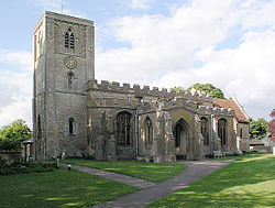
Holy Trinity church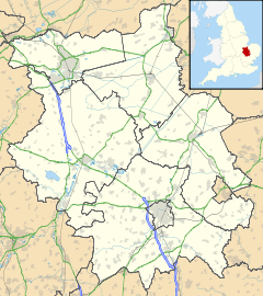
 Meldreth
Meldreth shown within CambridgeshirePopulation 1,641 [1] OS grid reference TL375466 Shire county Cambridgeshire Region East Country England Sovereign state United Kingdom Post town ROYSTON Postcode district SG8 Dialling code 01763 EU Parliament East of England List of places: UK • England • Cambridgeshire Meldreth is a village in South Cambridgeshire with about 1,600 inhabitants lying around 10 miles south-west of Cambridge.
Contents
History
The village of Meldreth grew in Saxon times, and the parish is home to Mettle Hill (formerly known as Motlowehyll) that was probably the original meeting place of Armingford Hundred. Listed as Melrede in the Domesday Book, the village's name means "mill stream", named after the stream that rises at Melbourn Bury and flows north into the River Cam.[2][3]
Due to its proximity to Cambridge, much of the land has at some time been owned by colleges of the University of Cambridge. In the early 16th century, Christ's College moved to its Meldreth estate to escape the plague.[3]
The Domesday Book compiled in 1086 has this listing for the village:
Melrede: Abbot of Ely and Hardwin and Guy de Raimbeaucourt from him; Abbot of St. Evroul from Earl Roger; Colswein from Count Alan; Hardwin of Scales and Hugh from him; Guy de Raimbeaucourt. 7½ mills, monastery.
In 1952, the Royal Train carrying King George VI's body passed through the station on its journey from Sandringham to London. Residents gathered on the platform to pay their last respects to the King.
The village still has a stocks and whipping post, the traditional medieval punishment, last used in the village in 1860.[4]
Church
The parish church, dedicated to the Holy Trinity since 1443, consists of a chancel, aisled nave with south porch, and a west tower housing five bells. The chancel is unusually long and dates from the 12th century, perhaps indicating the existence of an earlier minster on the site. The tower dates from the late 12th century, with the top stage added in the late 13th century.[3]
Village life
The village, once famous for its fruit production, is now home to many commuters who work in Cambridge and London. Orchards still exist in Meldreth, and locally-grown fruits and vegetables are sold in the village, most notably the Meldreth greengage.
The village retains its own railway station which opened in 1851. In 2001, local celebrations marked the 150th anniversary of Meldreth railway station, which serves the residents of Meldreth and the neighbouring village of Melbourn. Trains from the station run into Cambridge and London King's Cross.
Only one public house is still open; The British Queen has been open since the first half of the 19th century. The first recorded pub in the village was The Bell (also known as The Old Bell or The Blue Bell Inn) which was housed in a thatched building that was built in 1676 and first recorded as a public house in 1726. The Bell closed in 1910. The Railway Tavern opened in 1858 and closed in 1959. It now houses the Tavern Art Gallery. Other former pubs include The Chequer, recorded in 1785 but believed to have closed soon after, and The Green Man which stood next to the brewery at North End and was open from 1808 till the late 19th century.[3][4]
Meldreth is home to Meldreth Manor School, run by the charity Scope.
Prime Meridian
 Prime Meridian marker in Meldreth.
The prime meridian runs through the village. A stone marker was erected near the western end of Fenny Lane, and unveiled in December 1999 by the Astronomer Royal, Sir Martin Rees.
References
- ^ 2001 Census
- ^ A. D. Mills (2003). "A Dictionary of British Place-Names". http://www.encyclopedia.com/doc/1O40-Meldreth.html.
- ^ a b c d A History of the County of Cambridge and the Isle of Ely. 8. Victoria County History. 1982. pp. 83–97. http://www.british-history.ac.uk/report.aspx?compid=66744.
- ^ a b "Meldreth history". http://www.meldrethhistory.org.uk/.
External links
- Meldreth Parish Council's website
- Meldreth website, information on the history of the village and a Meldreth Today section
- Meldreth Community Archive
- Meldreth Matters, the monthly village magazine
- Meldreth Primary School
Categories:- Villages in Cambridgeshire
- Civil parishes in Cambridgeshire


Wikimedia Foundation. 2010.