- Mission Indians
-
Mission Indians is a term for many Native California tribes, primarily living in coastal plains, adjacent inland valleys and mountains, and on the Channel Islands in central and southern California, United States. The tribes had established comparatively peaceful cultures varying from 250 to 8,000 years before Spanish contact. These resident indigenous peoples of the Americas were forcibly relocated from their traditional dwellings, villages, and homelands to live and work at twenty one Spanish missions in California, and the Asisténcias and Estáncias as they were established between 1796 and 1823 in the Las Californias Province of the Viceroyalty of New Spain.
 Ruin of the Indian quarters, Mission San Luis Rey
Contents
History
Spanish explorers arrived on California's coasts as early as the mid-16th century. In 1769 the first Spanish Franciscan mission was built in San Diego. Local tribes were relocated and conscripted into forced labor on the mission, stretching from San Diego to San Francisco. Disease, starvation, over work, and torture decimated these tribes.[1] Many were forcibly converted and baptized as Roman Catholics by the Franciscan missionaries at the missions.
Mission Indians were from many Californian Native American tribes that were relocated together in new mixed groups and renamed after the responsible mission. For instance the Payomkowishum were renamed "Luiseños" after the Mission San Luis Rey and the Acjachemem were renamed the "Juaneños" after the Mission San Juan Capistrano.[2] The Catholic priests forbid the Indians from practicing their native culture, resulting in the virtual extinction of the Indian's original linguistic, spiritual, and cultural practices. With no immunity to European diseases, and changed cultural and lifestyle demands, the population of Native American Mission Indians significantly decreased during the mission period and after.
Mexico gained control of Californian missions in 1834 and abuse persisted, but the missions were soon secularized and lands were transferred to non-Native administrators. Many of the Mission Indians then worked on the newly-established ranchos, with little improvement in their conditions.[1]
The term "Mission Indians" was initially applied to Southern California Native Americans as an ethnographic and anthropological label around 1906 by Alfred L. Kroeber and Constance G. Du Bois at the University of California, Berkeley at Mission San Luis Obispo de Tolosa and south.[3][4] Today it is also sometimes used for Northern California Native Americans to include populations at the eleven Northern California missions, Mission San Miguel Arcángel and north.
Missions
 Indian cemetery at Mission San Carlos Borromeo, Carmel, California
Missions that the tribes were associated with including the following:
- Those with ancestors at the Missions, Asisténcias, and Estáncias of;
-
- Mission San Luis Obispo de Tolosa, in San Luis Obispo
- Mission La Purísima Concepción, northeast of Lompoc
- Mission Santa Inés, in Solvang
- Mission Santa Barbara, in Santa Barbara
- Mission San Buenaventura, in Ventura
- Mission San Fernando Rey de España, in Mission Hills (Los Angeles)
- Mission San Gabriel Arcángel, in San Gabriel
- Mission San Juan Capistrano, in San Juan Capistrano
- Mission San Luis Rey de Francia, in Oceanside
- Mission San Diego de Alcalá, in San Diego
- Santa Ysabel Asistencia, founded in 1818 in Santa Ysabel
- San Antonio de Pala Asistencia (Pala Mission), founded in 1816 in eastern San Diego County
- San Bernardino de Sena Estancia, founded in 1819 in Redlands
- Santa Ana Estancia, founded in 1817 in Costa Mesa
- Las Flores Estancia (Las Flores Asistencia), founded in 1823 in Camp Pendleton
Mission tribes
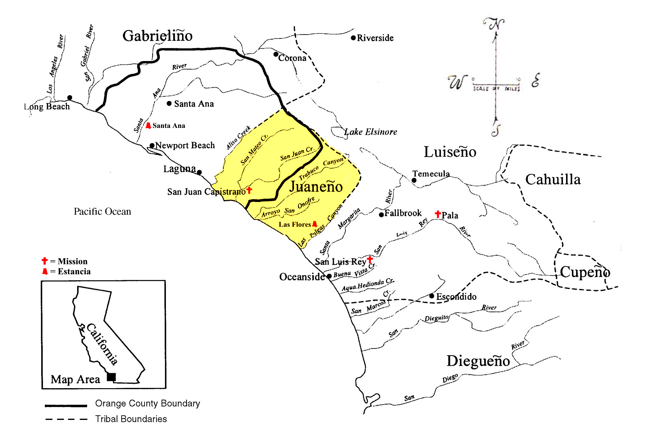
 The territorial boundaries of the Southern California Indian tribes based on dialect, including the Cahuilla, Cupeño, Diegueño, Gabrieliño, Juaneño (highlighted), and Luiseño language groups.[5]
Current Mission Indian tribes include the following in Southern California:
- Agua Caliente Band of Mission Indians (Cahuilla)
- Augustine Band of Mission Indians (Cahuilla)
- Barona Band of Mission Indians (Kumeyaay/Diegueño)
- Cabazon Band of Mission Indians (Cahuilla)
- Cahuilla Band of Mission Indians (Cahuilla)
- Campo Band of Mission Indians (Kumeyaay/Diegueño)
- Capitan Grande Band of Mission Indians (Kumeyaay/Diegueño)
- Costanoan Band of Carmel Mission Indians (Ohlone)
- Cuyapaipe Band of Mission Indians (Kumeyaay/Diegueño)
- Inaja and Cosmit Band of Mission Indians (Kumeyaay/Diegueño)
- Jamul Band of Mission Indians (Kumeyaay/Diegueño)
- La Jolla Band of Mission Indians (Luiseño)
- La Posta Band of Mission Indians (Kumeyaay/Diegueño)
- Los Coyotes Band of Mission Indians (Cahuilla and Cupeño)
- Manzanita Band of Mission Indians (Kumeyaay/Diegueño)
- Mesa Grande Band of Mission Indians (Kumeyaay/Diegueño)
- Morongo Band of Mission Indians (Cahuilla, Serrano and Cupeño)
- Pala Band of Mission Indians (Cupeño and Luiseño)
- Pauma Band of Mission Indians (Luiseño)
- Pechanga Band of Mission Indians (Luiseño)
- Ramona Band or Village of Mission Indians (Cahuilla)
- San Manuel Band of Mission Indians (Serrano)
- San Pasqual Band of Mission Indians (Kumeyaay/Diegueño)
- Santa Rosa Band of Mission Indians (Cahuilla)
- Santa Ynez Band of Mission Indians (Chumash)
- Santa Ysabel Band of Mission Indians (Kumeyaay/Diegueño)
- Soboba Band of Mission Indians (Luiseño)
- Sycuan Band of Mission Indians (Kumeyaay/Diegueño)
- Torres-Martinez Band of Mission Indians (Cahuilla)
- Twenty-Nine Palms Band of Mission Indians[6] (Chemehuevi)[7]
- Current Mission Indian Tribes north of the present day ones listed above, in the Los Angeles Basin, Central Coast, Salinas Valley, Monterey Bay and San Francisco Bay Areas also were identified with the local Mission of their Indian Reductions in those regions.
Reservations
Most of the Indian tribes from San Luis Obispo County south to the Mexican border, and from the coast inland extending into the Coachella Valley and parts of the Mojave Desert had some interaction with the missions. In contemporary times many have an ongoing and historic association with the Catholic missions and some also occupy trust lands--Indian Reservations-- identified under the Mission Indian Agency. The Mission Indian Act of 1891 formed the administrative Bureau of Indian Affairs unit which governs San Diego County, Riverside County, San Bernardino County, and Santa Barbara County. There is one Chumash reservation in the last county, and more than thirty reservations in the others.
Los Angeles County, San Luis Obispo County, and Orange County do not contain any tribal trust lands. However resident tribes, including the Tongva in the first and the Juaneño-Acjachemen Nation in the last (as well as the Coastal Chumash in Santa Barbara County) continue seeking federal Tribal recognition by the U.S. Bureau of Indian Affairs.
Eleven of the Southern California reservations came under the early 20th century allotment programs, which broke up common tribal holdings to assign property to individual tribal members, identified on such lists as the Dawes Rolls. The most important of these include: the Agua Caliente Reservation in Palm Springs, which occupies alternate sections (approx.640 acreseach) with former railroad grant lands that form much of the city; the Morongo Reservation in the San Gorgonio Pass area; and the Pala Reservation on the site of San Antonio de Pala Asistencia (Pala Mission) of the Mission San Luis Rey de Francia in Pala. These and fifteen other reservations operate casinos today. The total acreage of the Mission group of reservations constitutes approximately 250,000 acres (1,000 km2).
Online Narratives
- "Two Myths of the Mission Indians of California" by Alfred L. Kroeber (1906)
- "Mythology of the Mission Indians" (1) by Constance Goddard DuBois (1906)
- "Mythology of the Mission Indians" (2) by Constance Goddard DuBois (1906)
See also
- California mission clash of cultures
- Population of Native California
- Native American history of California
- Native Americans in California
- Slavery among Native Americans in the United States
- Indian Reductions
- American Indian reservations in California
Notes
- ^ a b Pritzker, 114
- ^ Pritzker, 129
- ^ Kroeber 1906:309.
- ^ Du Bois 1904-1906.
- ^ After Kroeber, 1925
- ^ "California Indian Tribes and Their Reservations: Mission Indians." SDSU Library and Information Access. (retrieved 6 May 2010)
- ^ "Tribal History." Spotlight 29 Casino. (retrieved 6 May 2010)
References
- Du Bois, Constance Goddard. 1904-1906. "Mythology of the Mission Indians", The Journal of the American Folk-Lore Society, Vol. XVII, No. LXVI. p. 185-8 [1904]; Vol. XIX. No. LXXII pp. 52-60 and LXXIII. pp. 145-64. 1906. ("the mythology of the Luiseño and Diegueño Indians of Southern California")
- Kroeber, Alfred. 1906. "Two Myths of the Mission Indians of California", Journal of the American Folk-Lore Society, Vol. XIX, No. LXXV pp. 309-21.
- Pritzker, Barry M. A Native American Encyclopedia: History, Culture, and Peoples. Oxford: Oxford University Press, 2000. ISBN 978-0195138771.
Further reading
- Shipek, Florence C. "History of Southern California Mission Indians." Robert F. Heizer, ed. Handbook of North American Indians: California. Washington, D. C.: Smithsonian Institution, 1978.
- Shipek, Florence (1988). Pushed into the Rocks: Southern California Indian Land Tenure 1767–1986. Lincoln: University of Nebraska Press.
- Sutton, Imre (1964). Land Tenure and Changing Occupance on Indian Reservations in Southern California. Ph.D. dissertation in Geography, UCLA.
- Sutton, Imre (1967). "Private Property in Land Among Reservation Indians in Southern California," Yearbook, Assn of Pacific Coast Geographers, 29:69-89.
- Valley, David J. (2003). Jackpot Trail: Indian Gaming in Southern California San Diego: Sunbelt Publications.
- White, Raymond C. (1963). "A Reconstruction of Luiseño Social Organization." University of California, Publications in American Archaeology and Ethnology. Volume 49, no. 2.
Population groups of Native California Achomawi · Atsugewi · Bay Miwok · Cahuilla · Chemehuevi · Chimariko · Chumash · Coast Miwok · Cupeño · Eel River Athapaskans (Lassik, Nongatl, Sinkyone, Wailaki) · Esselen · Gabrielino (Tongva) · Halchidhoma · Hupa (Chilula, Whilkut) · Juaneño (Acjachemen) · Karuk · Kato · Kawaiisu · Kitanemuk · Kumeyaay (Diegueño, Ipai, Tipai) · Lake Miwok · Luiseño · Maidu · Mattole (Bear River) · Modoc (Klamath) · Mohave · Mono (Monache, Owens Valley Paiute) · Nomlaki · Northern Paiute · Ohlone (Costanoan) · Patwin · Pomo · Quechan (Yuma) · Salinan · Serrano · Shasta (Konomihu, Okwanuchu) · Tataviam · Timbisha · Tolowa · Tübatulabal · Valley and Sierra Miwok · Wappo · Washoe · Wintu · Wiyot · Yana · Yokuts · Yuki · Yurok
California missions San Diego de Alcalá (1769) · San Carlos Borromeo de Carmelo (1770) · San Antonio de Padua (1771) · San Gabriel Arcángel (1771) · San Luis Obispo de Tolosa (1772) · San Francisco de Asís (1776) · San Juan Capistrano (1776) · Santa Clara de Asís (1777) · San Buenaventura (1782) · Santa Barbara (1786) · La Purísima Concepción (1787) · Santa Cruz (1791) · Nuestra Señora de la Soledad (1791) · San José (1797) · San Juan Bautista (1797) · San Miguel Arcángel (1797) · San Fernando Rey de España (1797) · San Luis Rey de Francia (1798) · Santa Inés (1804) · San Rafael Arcángel (1817) · San Francisco Solano (1823)
Asistencias
Nuestra Señora Reina de los Angeles (1784) · San Pedro y San Pablo (1786) · Santa Margarita de Cortona (1787) · San Antonio de Pala (1816) · Santa Ysabel (1818)Estancias
San Bernardino de Sena (1819) · Santa Ana (1820) · Las Flores (1823)History of California to 1899 Precontact · First explorations · Later explorations · Spanish colonization · Russian colonization · Mexican rule · California Trail · Mexican-American War · U.S. rule · Gold Rush · Civil War
since 1900 By topic By city Los Angeles · Riverside · Sacramento · San Bernardino · San Diego · San Francisco · San Jose
Categories:- California Mission Indians
- Spanish missions in California
- Native American history
- Native American history of California
- Native American tribes in California


Wikimedia Foundation. 2010.