- Gloucestershire
-
"County of Gloucester" redirects here. For other uses, see Gloucester County (disambiguation).
Gloucestershire 
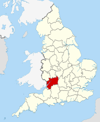
Geography Status Ceremonial & (smaller) Non-metropolitan county Region South West England Area
- Total
- Admin. council
- Admin. areaRanked 16th
3,150 km2 (1,220 sq mi)
Ranked 13th
2,653 km2 (1,024 sq mi)Admin HQ Gloucester ISO 3166-2 GB-GLS ONS code 23 NUTS 3 UKK13 Demography Population
- Total (2010 est.)
- Density
- Admin. council
- Admin. pop.Ranked 26th
858,300
272 /km2 (700 /sq mi)
Ranked 20th
593,500Ethnicity 97.3% White Politics 
Gloucestershire County Council
http://www.gloucestershire.gov.ukExecutive Conservative Members of Parliament - Geoffrey Clifton-Brown (C)
- Richard Graham (C)
- Neil Carmichael (C)
- Mark Harper (C)
- Martin Horwood (LD)
- Laurence Robertson (C)
Districts 
Gloucestershire (
 i/ˈɡlɒstərʃər/ gloss-tər-shər) is a county in South West England. The county comprises part of the Cotswold Hills, part of the flat fertile valley of the River Severn, and the entire Forest of Dean.
The county town is the city of Gloucester, and other principal towns include Cheltenham, Cirencester, Stroud, and Tewkesbury.
When considered as a ceremonial county, Gloucestershire borders the preserved county of Gwent in Wales (now Monmouthshire), and in England the ceremonial counties of Herefordshire, Worcestershire, Warwickshire, Oxfordshire, Wiltshire and Somerset. Ceremonially, it includes the area covered by the South Gloucestershire unitary authority.
According to a 2002 campaign by the charity Plantlife, the county flower of Gloucestershire is the Wild Daffodil.[1]
Contents
History
Main article: History of GloucestershireGloucestershire is a historic county mentioned in the Anglo-Saxon Chronicle in the 10th century, though the areas of Winchcombe and the Forest of Dean were not added until the late 11th century. Gloucestershire originally included the "small town" of Bristol. The "local" rural community moved to the port city, (as Bristol was to become) and Bristol's population growth accelerated during the industrial revolution. Bristol became part of the administrative County of Avon in 1974.
Upon the abolition of Avon in 1996, the region north of Bristol became a unitary authority area of South Gloucestershire and is now part of the ceremonial county of Gloucestershire.
The official former postal county abbreviation was "Glos.", rather than the frequently used but erroneous "Gloucs." or "Glouc.".
In July 2007, Gloucestershire suffered the worst flooding in recorded British history, with tens of thousands of residents affected. The RAF conducted the largest peace time domestic operation in its history to rescue over 120 residents from flood affected areas. The damage was estimated at over £2 billion.[2]
The county recovered rapidly from the disaster, investing in attracting tourists to visit the many sites and diverse range of shops in the area.
Economy
This is a chart of trend of regional gross value added of Gloucestershire at current basic prices published (pp. 240–253) by Office for National Statistics with figures in millions of British Pounds Sterling.
Year Regional Gross Value Added[3] Agriculture[4] Industry[5] Services[6] 1995 5,771 196 1,877 3,698 2000 8,163 148 2,677 5,338 2003 10,617 166 2,933 7,517 Education
Secondary schools
See List of schools in Gloucestershire.
Gloucestershire has mainly comprehensive schools with seven selective schools; two are in Stroud (Stroud High School for girls and Marling School for boys), one in Cheltenham (Pate's Grammar) and four in Gloucester (Sir Thomas Rich's and The Crypt for boys and The High School and Ribston Hall for girls). There are 42 state secondary schools, not including sixth form colleges, and 12 independent schools, including the renowned Cheltenham Ladies' College, Cheltenham College and Dean Close School. All but about two schools in each district have a sixth form, but the Forest of Dean only has two schools with sixth forms. All schools in South Gloucestershire have sixth forms.
Higher and further education
Gloucestershire has one university, the University of Gloucestershire, one university college, the Royal Agricultural College, and four higher and further education colleges, Gloucestershire College, Cirencester College, Stroud College and the Royal Forest of Dean College. Each has campuses at multiple locations throughout the county.
Towns and villages
The towns in Gloucestershire are:
Towns in South Gloucestershire (historically part of Gloucestershire) are:
Main article: list of places in GloucestershireAntiquities
The cathedral of Gloucester, the magnificent abbey church of Tewkesbury, and the church of Cirencester with its great Perpendicular porch, are described under their separate headings. Of the abbey of Hailes near Winchcombe, founded by Richard, Earl of Cornwall, in 1246, little more than the foundations are left, but these have been excavated and interesting fragments have been brought to light.
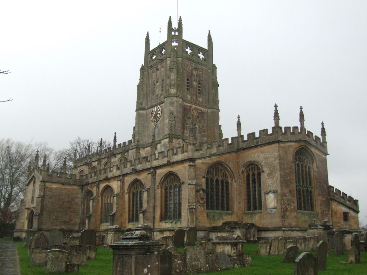
 Parish Church of St. Mary, Fairford
Most of the old market towns have fine parish churches. At Deerhurst near Tewkesbury, and Bishop's Cleeve near Cheltenham, there are churches of special interest on account of the pre-Norman work they retain. The Perpendicular church at Lechlade is unusually perfect; and that at Fairford was built (c. 1500), according to tradition, to contain the remarkable series of stained-glass windows which are said to have been brought from the Netherlands. These are, however, adjudged to be of English workmanship, and are one of the finest series in the country.
Calcot Barn is an interesting relic of Kingswood Abbey. Thornbury Castle is a Tudor country house, the pretensions of which evoked the jealousy of Cardinal Wolsey against its builder, Edward Stafford, duke of Buckingham, who was beheaded in 1521. Near Cheltenham is the fine 15th-century mansion of Southam de la Bere, of timber and stone.[citation needed] Memorials of the de la Bere family appear in the church at Cleeve. The mansion contains a tiled floor from Hailes Abbey. At Great Badminton is the mansion and vast domain of the Beauforts (formerly of the Botelers and others), on the south-eastern boundary of the county. At Owlpen is one of the most picturesque Tudor manor houses set in a densely-wooded valley.
There are several royal residences in Gloucestershire, including Highgrove House, Gatcombe Park, and (formerly) Nether Lypiatt Manor.
An annual "cheese-rolling" event takes place at Cooper's Hill, near Brockworth and the Cotswold Games occurred within the county.
Places of interest
Key 
Abbey/Priory/Cathedral 
Accessible open space 
Amusement/Theme Park 
Castle 
Country Park 
English Heritage 
Forestry Commission 
Heritage railway 
Historic House 

Museum (free/not free) 
National Trust 
Zoo Places of interest in Gloucestershire include:
- Badminton House, residence of the Dukes of Beaufort.
- Berkeley Castle, an example of a feudal stronghold.
- Beverston Castle
- Chavenage House

- Dyrham Park
- Edward Jenner's House
- Gloucester Cathedral
- Gloucestershire Warwickshire Railway

- Hailes Abbey
- Newark Park
- Owlpen Manor
- Snowshill Manor
- Sudeley Castle
- Stanway House
- Rodmarton Manor
- Tewkesbury Abbey
- Tyndale Monument

- Wildfowl and Wetland Trust, Slimbridge
- Woodchester Mansion
Areas of countryside in Gloucestershire include:
Media
Gloucestershire's daily newspapers are The Citizen, which covers Gloucester, Stroud and the Forest of Dean, and the Gloucestershire Echo, which covers Cheltenham, Tewkesbury and the Cotswolds. The two daily papers, along with free weeklies The Forester, Stroud Life, The Gloucester News and The Cheltenham and Tewkesbury News, are all published by Northcliffe Media.[7] The Stroud News & Journal is a weekly paid-for newspaper based in Stroud. It is published in a tabloid format by Newsquest. Newsquest also produces the weekly Wilts and Glos Standard newspaper, which covers the southern and eastern parts of the county.
Radio stations in Gloucestershire include BBC Radio Gloucestershire and Heart Gloucestershire, and Total Star Gloucestershire. There are also several community radio stations including Gloucester FM, Radio Winchcombe, Forest of Dean Radio, and North Cotswold Community Radio.
Gloucestershire in popular culture
Part of Mrs. Craik's novel John Halifax, Gentleman is set in Enderley, a thinly disguised Amberley, where she lived at the time of writing.[8] Most of the book is set in Nortonbury, easily recognisable as Tewkesbury. The county has also been the setting for a number of high profile movies and TV series, including Die Another Day, Harry Potter and BBC TV series Butterflies.[9]
Notable people
- Steve Banyard, football commentator, lives in the Cotswolds
- Button Gwinnett, second of the signatories (first signature on the left) on the United States Declaration of Independence
- Ernest Cossart, Hollywood actor and brother of Gustav Holst
- Johnny Coppin, folk musician/composer lives in the county[10]
- P J Crook, artist, born and lives near Cheltenham
- Sir Martin Evans, winner of the Nobel Prize in Physiology or Medicine
- Winifred Foley, writer, best known for her autobiography A Child in the Forest
- Ivor Gurney, composer and poet
- Sir Frederick Handley Page, aircraft designer, best known for WW2 aircraft, including the Halifax bomber[11]
- Robert Hardy, actor
- Ricci Harnett, actor
- Gustav Holst, composer
- Imogen Holst, composer and conductor
- Herbert Howells, composer
- Edward Jenner, who discovered vaccination, initially against smallpox, and lived in Berkeley
- Dom Joly, star of Trigger Happy TV, lives in Quenington
- Brian Jones, ex-guitarist for the Rolling Stones
- Alex Kapranos, lead singer and guitarist for the band Franz Ferdinand
- Laurie Lee, poet and author of Cider with Rosie and other autobiographical works
- Joe Meek, 1960s pop record producer and pioneer, born in Newent
- William Moseley, actor best known for Peter in The Chronicles of Narnia
- J.I. Packer, theologian
- Simon Pegg, actor and comedian
- Dennis Potter, dramatist
- JK Rowling, author of the Harry Potter books
- Robert Charles "Jack" Russell, former Gloucestershire and England cricketer, now an artist
- Tom Smith, lead singer of the rock band Editors
- Kate Thornton, TV presenter
- Brian Trubshaw, first British man to test pilot Concorde
- Carl Trueman, theologian and church historian
- Fred West, one of Britain's most notorious serial killers
- Dick Whittington, London Mayor and inspiration for the Pantomime character
- Vaughan Williams, composer
- Edward Adrian Wilson, Antarctic explorer
See also
- Lord Lieutenant of Gloucestershire
- High Sheriff of Gloucestershire
- Category:Grade I listed buildings in Gloucestershire
- Diocese of Gloucester
- Flag of Gloucestershire
- Gloucestershire County Cricket Club
- Gloucestershire Old Spots Pig
- Gloucestershire Regiment
- Royal Gloucestershire Hussars
- West Country dialects
Notes
- ^ BBC News, http://news.bbc.co.uk/1/hi/sci/tech/3684291.stm, 5 May 2004. Retrieved 8 April 2006.
- ^ BBC – News Flood crisis grows as rivers rise
- ^ Components may not sum to totals due to rounding
- ^ includes hunting and forestry
- ^ includes energy and construction
- ^ includes financial intermediation services indirectly measured
- ^ Gloucestershire Media Group's portfolio – Northcliffe Media subsidiary which publishes local papers in Gloucestershire
- ^ British History Online
- ^ 'Gloucestershire TV and Movie Locations' at Gloucestershire On Screen
- ^ "Official Homepage". Johnny Coppin. http://www.johnnycoppin.co.uk/. Retrieved 8 May 2010.
- ^ Encyclopaedia Brittanica
External links
- Gloucestershire County Council Local government web site
- Gloucestershire at the Open Directory Project
Ceremonial county of Gloucestershire Unitary authorities Boroughs or districts Major settlements - Berkeley
- Bradley Stoke
- Cheltenham
- Chipping Campden
- Chipping Sodbury
- Cinderford
- Cirencester
- Coleford
- Dursley
- Fairford
- Filton
- Gloucester
- Kingswood
- Lechlade
- Lydney
- Minchinhampton
- Mitcheldean
- Moreton-in-Marsh
- Nailsworth
- Newent
- Northleach
- Painswick
- Patchway
- Stonehouse
- Stow-on-the-Wold
- Stroud
- Tetbury
- Tewkesbury
- Thornbury
- Winchcombe
- Wotton-under-Edge
- Yate
See also: List of civil parishes in Gloucestershire
Rivers Topics - History
- Museums
Categories:- Gloucestershire
- Non-metropolitan counties


Wikimedia Foundation. 2010.