- Ohio State Route 43
-
State Route 43
Route information Maintained by ODOT Length: 122.69 mi[1] (197.45 km) Existed: 1924 – present Major junctions South end:  SR 7 in Steubenville
 I-76 near Kent

 I-77 / I-490 in Cleveland
 I-90 in Cleveland
North end: 
 US 6 / US 42 in Cleveland
Location Counties: Jefferson, Carroll, Stark, Portage, Geauga, Cuyahoga Highway system Ohio highways
Interstates • U.S. Routes • State Routes←  SR 41
SR 41SR 44  →
→State Route 43 (SR 43, OH 43) is a north–south state highway that runs through the northeastern quadrant of the U.S. state of Ohio. Its southern terminus is at a signalized intersection with State Route 7 along the Ohio River in Steubenville, and its northern terminus is approximately 123 miles (198 km) to the north at Public Square in Cleveland.
Created in the mid 1920s, State Route 43 starts out in Steubenville, and runs northwesterly to Canton via Carrollton. From Canton, the highway runs northerly through Kent and Streetsboro to Aurora, where it then turns northwesterly, and passes through suburban Cleveland before entering the city proper, and coming to an end in downtown at Public Square. For its northernmost stretch of less than 1 mile (1.6 km), State Route 43 shares the same portion of pavement as four other highways at the same time: U.S. Route 422, State Route 8, State Route 14 and State Route 87. The five routes share a common endpoint in the middle of Public Square, where they intersect the triplex of U.S. Route 6, U.S. Route 42 and State Route 3.
Contents
Route description
State Route 43 runs through the counties of Jefferson, Carroll, Stark, Portage, Geauga and Cuyahoga.
The portion of State Route 43 beginning with its concurrent section with U.S. Route 30 in Canton, north through Kent and to Aurora, then northwest to the State Route 91 junction in Solon is included within the National Highway System, a system of highways deemed most important for the country's economy, defense and mobility.[2]
Jefferson County
Beginning in Jefferson County at its southern terminus at a signalized intersection with State Route 7 in Steubenville along the Ohio River and the Ohio-West Virginia border across from Weirton, West Virginia, State Route 43 follows Washington Street northwesterly before becoming a short divided highway just west of downtown. State Route 43 then becomes Sunset Boulevard, and heads westerly into Winterville, where it is known as Main Street. The state highway then departs the town to the northwest along Canton Road, leading up to a diamond interchange with the U.S. Route 22 freeway. State Route 43 next runs northwesterly into the village of Richmond, where it is briefly co-signed with State Route 152. State Route 43 then trends westerly into the unincorporated community of East Springfield, before turning northerly and passing through the small village of Amsterdam, where it is briefly joined by State Route 164. State Route 43 departs Jefferson County as it exits the village to the northwest, and enters into Carroll County.
Carroll County
State Route 43 is almost entirely rural in Carroll County, where it runs northwesterly into Harlem Springs along Steubenville Road, then turns westerly to its junction with State Route 9. The two highways then converge, and run northwesterly into Carrollton. State Route 9 and State Route 43 meet State Route 39 on the eastern outskirts of town, and the three highways run together northwesterly along East Main Street into downtown Carrollton and the triplex's junction with State Route 332, where State Route 9 departs to the north via North Lisbon Street. State Route 39 and State 43 then continue together along West Main Street to the Canton Road intersection, where State Route 43 splits from State Route 39, and follows Canton Road northerly out of Carrollton. The state route turns northwesterly, and comes to its eastern intersection with State Route 183 just east of Malvern. The two state routes run westerly through Malvern along Canal Street, then onto Alliance Road after departing the village, and ultimately to the point where they cross into Stark County.
Stark County
Into Stark County, State Route 43 jointly heads westerly with State Route 183 to the T-intersection that marks their western split just north of Waynesburg. Turning north, State Route 43 soon meets State Route 44 at its southern terminus. Turning northwesterly into rural Sandy Township, State Route 43 makes its way up into Canton. In Canton, running just to the east of, but never intersecting Interstate 77, State Route 43 has junctions with U.S. Route 30, State Route 172, State Route 153 and U.S. Route 62. State Route 43 then enters Plain Township, and passes northerly through a rural portion of Stark County prior to entering Hartville, where it meets State Route 619. After duplexing with State Route 619 for a short distance westerly, State Route 43 turns northerly again, and enters into Portage County.
Portage County
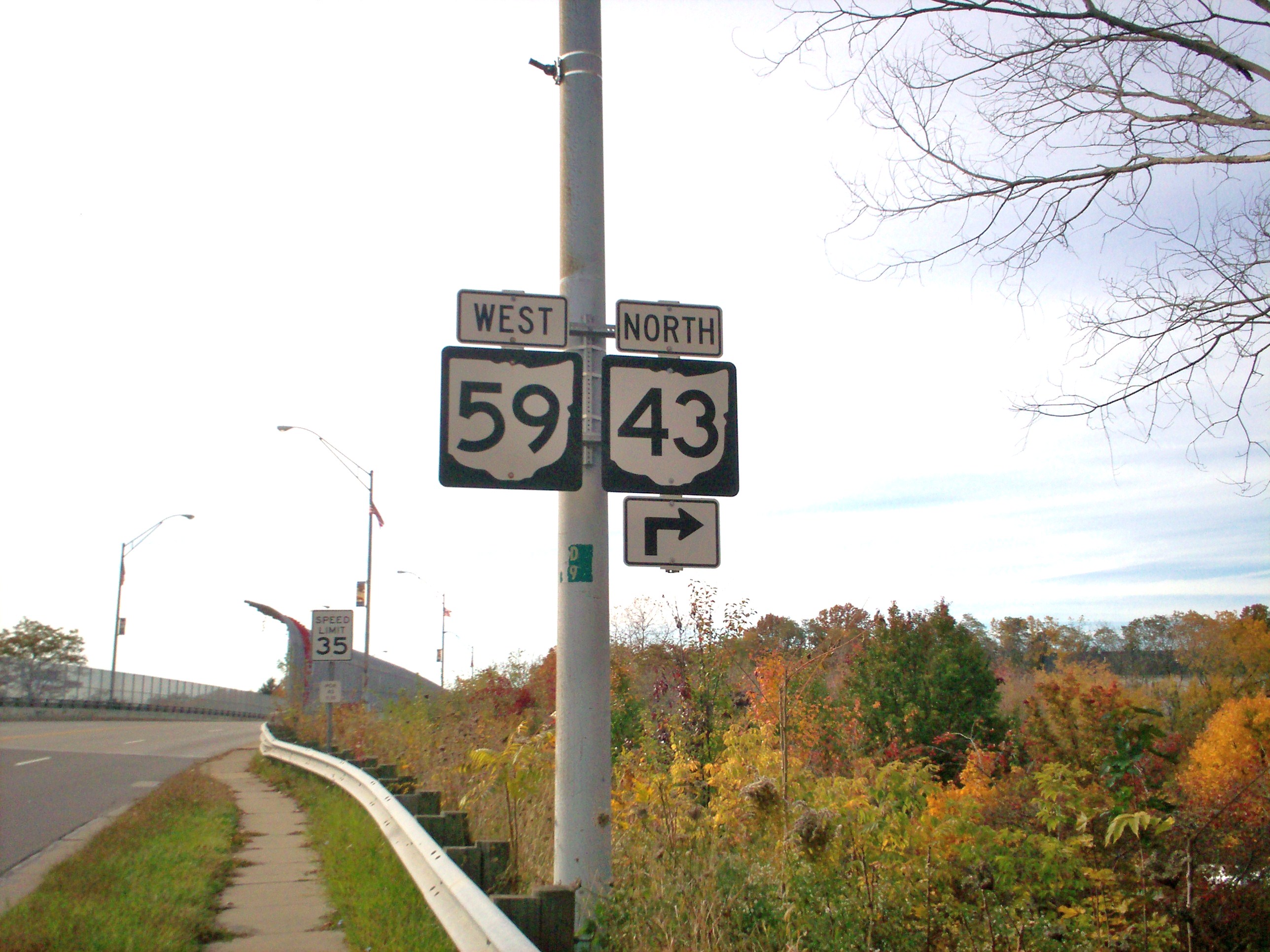
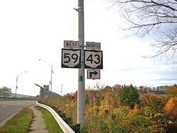 State Routes 59 and 43 cosigned in Kent
State Route 43 heads north through Suffield Township, where it meets U.S. Route 224. Further north, after crossing the Mogadore Reservoir, State Route 43 meets Interstate 76 at Exit 33 just south of Kent in Brimfield. Continuing north, the state highway enters Kent along South Water Street, and passes just to the west of the campus of Kent State University. Downtown, State Route 43 turns west onto Ohio State Route 59#Haymaker Parkway and is briefly co-signed with State Route 59 as it crosses the Cuyahoga River. Turning north again, State Route 43 is split into two one-way roads, with southbound traffic on North and South Mantua Streets, and northbound traffic using Gougler Avenue and River Street. When the two directions of traffic converge into North Mantua Street, State Route 43 becomes a four- to five-lane roadway. It runs north into Streetsboro where it meets cosigned State Route 14 and State Route 303. After crossing underneath the Ohio Turnpike, State Route 43 continues north into Aurora and is known as Chillicothe Road. Splitting from Chillicothe Road at the intersection marking the southern terminus of State Route 306 in downtown Aurora, State Route 43 turns to the northwest onto Aurora Road, and crosses State Route 82. After passing Geauga Lake and the adjacent waterpark Geauga Lake's Wildwater Kingdom, State Route 43 enters Geauga County.
Geauga County
State Route 43 clips the southwestern corner of the county in Bainbridge Township. The route is less than 1 mile (1.6 km) long in Geauga County. The posted direction changes from north–south to the southeast to east–west to the northwest in this small section, as of 2008.
Cuyahoga County
Entering into Cuyahoga County at Solon northwesterly along Aurora Road, State Route 43 meets State Route 91 (S.O.M. Center Road) in the downtown of the city. Into Bedford Heights, State Route 43 passes under the triangular interchange between Interstate 271, Interstate 480 and U.S. Route 422. On the other side of the triangle, the state highway passes through North Randall, where it briefly follows State Route 8 north before turning northwest onto Miles Road. After going through Warrensville Heights, State Route 43 enters Cleveland. At the Broadway Avenue intersection, State Route 43 meets State Route 14, and the two highways converge. From this point into downtown Cleveland, State Route 43 is no longer signed, although it has been in the past.[3][4] The combined state routes run northwesterly through the Slavic Village neighborhood, cross through partial interchanges with Interstate 77 and Interstate 490, and converge with U.S. Route 422, State Route 8 and State Route 87 onto Ontario Avenue. After intersecting Interstate 90, State Route 43 comes to an end along with the other four routes it is combined with at Public Square in downtown Cleveland, where the highways meet U.S. Route 6, U.S. Route 20, U.S. Route 42 and U.S. Route 322.
History
State Route 43 is one of the original state highways, though the initial designation as State Route 43 was only applied on the segment between Steubenville and Canton. Until 1926, the section of modern State Route 43 from Canton to Aurora was signed as State Route 89 while the section from Aurora to its northern junction with State Route 14 was designated as State Route 82.[5][6] In 1930, State Route 43 was rerouted along a previously unnumbered road which put it approximately one mile west of North Olmsted.[7] This section of road would be renumbered as State Route 17 in 1934.[8] The section from North Randall to downtown Cleveland was part of State Route 8 from 1931–1938. By 1939, State Route 43 was extended to downtown Cleveland, cosigned with State Route 14.[9] In 1975, State Route 43 was rerouted in Kent along the recently completed Haymaker Parkway. Previously it had followed South Water Street to Kent's center and then turned west over the Cuyahoga River along the Main Street bridge.[10][11]
Major intersections
County Location Mile[1] Destinations Notes Jefferson Steubenville 0.00 SR 7Southern terminus at signalized intersection. Wintersville 7.51  US 22
US 22Diamond interchange. Island Creek Township 7.79  SR 646
Signalized T-intersection marking eastern terminus of SR 646. Richmond 11.45  SR 152
T-intersection marking eastern split of SR 43/SR 152 duplex.
SR 152 joins from the northeast.11.62 SR 152Western split of SR 43/SR 152 duplex.
SR 152 departs to the southwest.Amsterdam 21.55  SR 164
T-intersection marking southern split of SR 43/SR 164 duplex.
SR 164 joins from the southwest.21.67 SR 164T-intersection marking northern split of SR 43/SR 164 duplex.
SR 164 departs to the north.Carroll Lee Township 29.05  SR 9
SR 9Y-intersection marking southern split of SR 9/SR 43 duplex.
SR 9 joins from the south.Center Township 33.93  SR 39
SR 39Y-intersection marking eastern split of SR 9/SR 39/SR 43 triplex.
SR 39 joins from the northeast.Carrollton 34.44 SR 9
 SR 332
Signalized intersection marking western split of SR 9/SR 39/SR 43 triplex. SR 9 departs to the northeast, while SR 39/SR 43 duplex continues to northwest.
Also marks northern terminus of SR 332.34.86 SR 39Signalized intersection marking western split of SR 39/SR 43 duplex.
SR 39 departs to the west.Harrison Township 37.90  SR 171
Brown Township 44.15  SR 183
Signalized T-intersection marking eastern split of SR 43/SR 183 duplex.
SR 183 joins from the northeast.Stark Sandy Township 49.55 SR 183Signalized T-intersection marking western split of SR 43/SR 183 duplex.
SR 183 departs to the south.49.75 SR 44Y-intersection marking southern terminus of SR 44. Canton 59.51  US 30
US 30Interchange marking eastern split of US 30/SR 43 duplex.
US 30 enters from the east.60.43 US 30Interchange marking western split of US 30/SR 43 duplex.
US 30 departs to the west.61.07 SR 43D Beginning of one-way couplet. Northbound via Cherry St. is mainline SR 43.
Southbound via Walnut St. is designated SR 43D.61.29  SR 172
SR 43 as one-way couplet meets SR 172 at pair of signalized intersections. 62.09  SR 153
SR 43 as one-way couplet meets SR 153 at pair of signalized intersections that mark its western terminus. 62.81 SR 43D End of one-way couplet. 63.53  US 62
US 62Interchange. Hartville 73.40  SR 619
Signalized intersection marking eastern split of SR 43/SR 619 duplex.
SR 619 enters from the east.73.90 SR 619Signalized intersection marking western split of SR 43/SR 619 duplex.
SR 619 departs to the west.Portage Suffield Township 78.35  US 224
Signalized intersection. Brimfield Township 83.88 I-76Exit 33 off of I-76, a diamond interchange. Kent 85.86  SR 261
Signalized intersection. 87.05  SR 59
SR 59Signalized intersection marking eastern split of SR 43/SR 59 duplex.
SR 59 joins from the east.87.29 SR 59Signalized intersection marking western split of SR 43/SR 59 duplex.
SR 59 departs to the west.Streetsboro 93.82  SR 14
SR 14
 SR 303
Signalized intersection. SR 14/SR 303 duplex travels through intersection west-to-east. Aurora 98.96  SR 306
Signalized intersection marking southern terminus of SR 306. 99.35  SR 82
SR 82Signalized intersection. Cuyahoga Solon 105.99  SR 91
SR 91Signalized intersection. Solon-Bedford Heights boundary 109.09  SR 175
Signalized intersection marking southern terminus of SR 175. Bedford Heights 110.81  SR 17
SR 17Signalized T-intersection marking eastern terminus of SR 17. Bedford Heights-Warrensville Heights boundary 111.49  SR 8
SR 8Signalized intersection marking southern split of SR 8/SR 43 duplex.
SR 8 joins from the south.North Randall 111.76 SR 8Signalized intersection marking northern split of SR 8/SR 43 duplex.
SR 8 departs to the north.Cleveland 117.20 SR 14Signalized intersection marking southeastern split of SR 14/SR 43 duplex.
SR 14 joins from the southeast. SR 43 is not signed from this point through its northern terminus.120.13 I-77Exit 161A off of I-77, a partial interchange. 120.50 I-490Exit 2B off of I-490, a partial interchange. 121.78  US 422
SR 8
 SR 87
SR 87Signalized intersection marking eastern split of US 422/SR 8/SR 14/SR 43/SR 87 concurrency.
The US 422/SR 8/SR 87 triplex departs to the east.122.04 I-90Interchange, exits 171A-B off of I-90. 122.11  SR 10
SR 10Signalized intersection marking eastern terminus of SR 10. 122.63  US 20
US 20Signalized intersection at southern end of Public Square. 122.69 US 6
US 42
 SR 3
SR 3Signalized intersection in the center of Public Square.
Northern terminus of SR 43, in common with termini of US 422, SR 8, SR 14 and SR 43.
US 6, US 42 and SR 3 cross southwest-to-northeast.1.000 mi = 1.609 km; 1.000 km = 0.621 mi References
- ^ a b Ohio Department of Transportation. "Technical Services Straight Line Diagrams". http://www.odotonline.org/techservapps/SLD/default.htm. Retrieved 2010-09-19.
- ^ Federal Highway Administration (December 2003) (PDF). National Highway System: Ohio (Map). http://www.fhwa.dot.gov/planning/nhs/maps/oh/oh_Ohio.pdf. Retrieved 2010-05-22.
- ^ Google Street View north end south end
- ^ Spangler, James R.; James A. Toman (2005). Images of America: Cleveland and Its Streetcars. Arcadia Publishing. p. 107. ISBN 0738539678.
- ^ Ohio Department of Transportation (1923). Map of Ohio Showing State Highway System (Map). http://www.dot.state.oh.us/Divisions/TransSysDev/Innovation/Prod_Services/TransMap/Documents/otm1923a.sid. Retrieved 22 September 2010.
- ^ Ohio Department of Transportation (1927). Map of Ohio Showing State Highway System (Map). http://www.dot.state.oh.us/Divisions/TransSysDev/Innovation/Prod_Services/TransMap/Documents/otm1927a.sid. Retrieved 22 September 2010.
- ^ Ohio Department of Transportation (1931). Map of Ohio Showing State Highway System (Map). http://www.dot.state.oh.us/Divisions/TransSysDev/Innovation/Prod_Services/TransMap/Documents/otm1931a.sid. Retrieved 22 September 2010.
- ^ Ohio Department of Transportation (1935). Map of Ohio Showing State Highway System (Map). http://www.dot.state.oh.us/Divisions/TransSysDev/Innovation/Prod_Services/TransMap/Documents/otm1935a.sid. Retrieved 22 September 2010.
- ^ Ohio Department of Transportation (1940). Ohio Highway Map (Map). http://www.dot.state.oh.us/Divisions/TransSysDev/Innovation/Prod_Services/TransMap/Documents/otm1940a.sid. Retrieved 22 September 2010.
- ^ Wardle, Michelle (2005). Images of America: Kent. Arcadia Publishing. p. 75. ISBN 0738533815.
- ^ United States Geological Survey (1960). Kent Quadrangle - Ohio (Map). 1:24,000. 7.5 Minute Series (Topographic).
External links
Categories:- Canton, Ohio
- Transportation in Carroll County, Ohio
- Transportation in Cuyahoga County, Ohio
- Transportation in Geauga County, Ohio
- Transportation in Jefferson County, Ohio
- Kent, Ohio
- Transportation in Portage County, Ohio
- Transportation in Stark County, Ohio
- State highways in Ohio
- Steubenville, Ohio
- Transportation in Cleveland, Ohio

Wikimedia Foundation. 2010.