- Mason-Dixon Trail
-
Mason-Dixon Trail 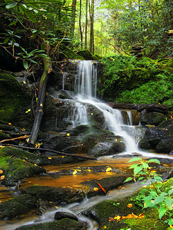
Oakland Run waterfalls as seen from the Mason-Dixon Trail in York County Length 190 miles (306 km) Location Delaware / Maryland / Pennsylvania, USA Trailheads Appalachian Trail at Whiskey Springs, Pennsylvania
Brandywine Creek at Chadds Ford, PennsylvaniaUse Hiking The Mason Dixon Trail connects the Appalachian Trail with the Brandywine Trail, passing through Gifford Pinchot State Park and White Clay Creek Preserve in Pennsylvania and White Clay Creek State Park in Delaware.
External links
Hiking Trails in Pennsylvania 202 • Appalachian • Baker • Black Forest • Brandywine • Bucktail Path • Chester Valley • Chuck Keiper • Conestoga • Cresheim • Cross County • Darlington • Donut Hole • Evansburg • Forbes Road • GAP • GET • Glacier Ridge • Golden Eagle • Horse Shoe • John P. Saylor • Laurel Highlands • Liberty Bell • Lost Turkey • Lower • Loyalsock • Mason-Dixon • Mid State • Mill Creek • Montour • North Country • Old Loggers Path • Panhandle • Pennypack • Perkiomen • Pinchot • Potomac Heritage • Power Line • Quebec Run • Quehanna • Rachel Carson • Rock Run • Schuylkill East • Schuylkill River • Standing Stone • Struble • Susquehannock • Tanbark • Terrace Mountain • Thunder Swamp • Tuscarora • Valley Forge • Warrior • West County • West Rim • Wissahickon • Youghiogheny River

Coordinates: 39°32′20″N 75°40′02″W / 39.53899°N 75.66730°W
Categories:- Protected areas of Cecil County, Maryland
- Protected areas of Harford County, Maryland
- Hiking trails in Delaware
- Hiking trails in Maryland
- Hiking trails in Pennsylvania
- Long-distance trails in the United States
- Protected areas of New Castle County, Delaware
- Protected areas of Chester County, Pennsylvania
- Protected areas of Delaware County, Pennsylvania
- Protected areas of York County, Pennsylvania
- Pennsylvania geography stubs
- United States trail stubs

Wikimedia Foundation. 2010.