- M-18 (Michigan highway)
-
This article is about the state highway in Michigan; for other uses, see M18 highway
M-18
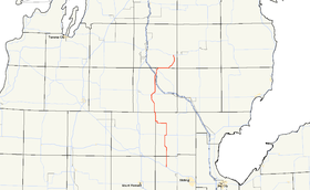
M-18 highlighted in redRoute information Maintained by MDOT Length: 77.530 mi[2] (124.772 km) Existed: c. July 1, 1919[1] – present Major junctions South end:  US 10 near North Bradley
 M-61 at Gladwin
 M-55 at Prudenville
 I-75 near Roscommon
North end: 
 M-72 / F-97 near Luzerne
Location Counties: Midland, Gladwin, Clare, Roscommon, Crawford Highway system Michigan State Trunkline Highway System
Interstate • US • State←  M-17
M-17M-19  →
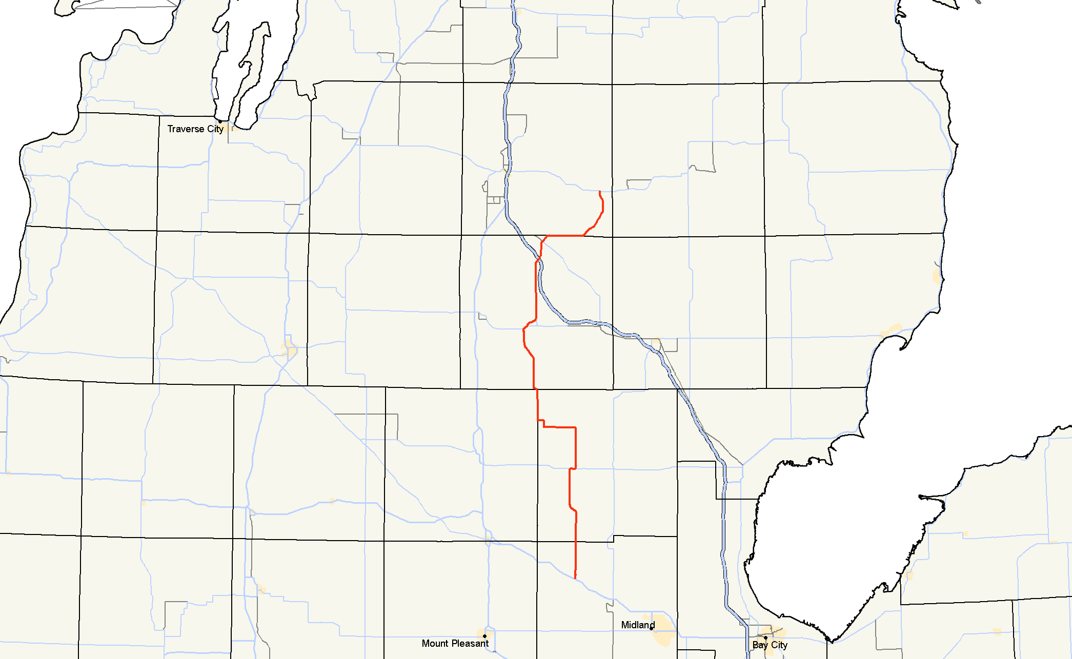
→M-18 is a north–south state trunkline highway in the Lower Peninsula of the US state of Michigan. It runs for 77.530 miles (124.772 km) through the central region of the state connecting US Highway 10 (US 10) near North Bradley with M-72 in rural Crawford County near the community of Luzerne. In between, the roadway connects several smaller communities while running through woodlands in a both state and national forest areas. Two segments of M-18 run along sections of county boundaries, and one part of the highway forms a component of the business loop for the village of Roscommon.
When the highway was first designated in the late 1910s, it extended farther south than it does today and ended well short of its current northern terminus. The southern end was added to another state highway, truncating M-18's length to roughly its current southern terminus in 1926. The northern end was also simultaneously extended for the first time with these revisions to the highway's routing. In the 1940s, the northern extension was reversed and then reinstated. M-18's course was last changed with the opening of three different freeways in the area in the 1960s and 1970s.
Contents
Route description
M-18 begins about 20 miles (32 km) northeast of Mount Pleasant at the North Bradley interchange on US 10 in rural Midland County. The highway runs due north through woodlands that are a part of the Au Sable State Forest and into Gladwin County. The trunkline enters the community of Beaverton and turns northwest to cross the section of the Tobacco River known as Ross Lake. Continuing northwesterly, the road runs along a section of the lake and then turns back due northerly. North of Beaverton, M-18 runs through some farm fields as it approaches the county seat of Gladwin. The highway runs through the southwestern outskirts of town near a golf course as it approaches a junction with M-61. M-18 merges with, and runs concurrently along, M-61 eastward into town on Cedar Avenue. At Silverleaf Street, M-18 turns back north near the airport. M-18 continues northward out of town back into farm country.[3][4]
The highway turns westward along Wirtz Road and past the southern terminus of county road F-97 in the northern part of Gladwin County. Near a crossing with the Cedar River , M-18 turns north along Bard Road and then west again along Renas Road. The highway returns to its northerly course when it turns to run along Clarwin Road, which runs along the Clare–Gladwin county line. The roadway angles to the northwest briefly, cutting across the extreme northeast corner of Clare County as the highway crosses into Roscommon County. Through the southern portion of the county, the road runs through the Roscommon forest management unit of the Au Sable State Forest as it approaches Prudenville. In that community, M-18 turns northeasterly and runs along M-55 along the eastern shore of Houghton Lake. The two highways separate on the eastern edge of town, and M-18 turns northward, intersecting the northern end of M-157. M-18 continues north, parallel to Interstate 75 (I-75) near Higgins Lake; M-18 crosses I-75 at exit 239 south of Roscommon.[3][4]
North of this freeway interchange, M-18 is also the route of Business Loop I-75 (BL I-75). The combined BL I-75/M-18 runs north near the Roscommon Conservation Airport and turns northeasterly into town. In the middle of Roscommon, BL I-75 turns northwest along Old 76 Road,[4] and M-18 continues northeasterly across a line of the Lake State Railway.[5] The highway continues independently to the northwest over the South Branch of the Au Sable River and out of town. It then turns due east along the Roscommon–Crawford county line. This section of the county line also forms the southern boundary of the Huron National Forest.[6] M-18 curves to the northeast off the county line into the national forest territory where it meets F-97 for a second time. At this junction, F-97 merges with M-18 and the two roads run due north to a junction with M-72 west of Luzerne. At this intersection, F-97 continues north and M-18 terminates in rural Crawford County.[3][4]
M-18 is maintained by the Michigan Department of Transportation (MDOT) like all other state trunkline highways. As a part of these maintenance responsibilities, the department tracks the traffic volumes along the roads under its jurisdiction using a measurement called annual average daily traffic (AADT). This is a metric for the level of traffic along a roadway segment for any average day of the year. In 2009, MDOT calculated that 14,017 vehicles used the section of M-18 along the M-61 concurrency, the highest traffic levels along M-18. The lowest AADT was found along the highway in Crawford County in the 2009 surveys. Commercial traffic varied between the 50 trucks daily in Crawford County and the 214 trucks a day north of Gladwin.[7] No section of M-18 has been listed on the National Highway System,[8] a networks of roads important to the country's economy, defense, and mobility.[9]
History
By July 1, 1919, M-18 was first designated on a routing that ran between M-46 west of Merrill through Edenville to M-14 (later US 27) in Prudenville.[1] The highway south of Beaverton was realigned to run due south a new terminus at North Bradley along the new US 10 in late 1926. The former routing between Beaverton and M-30 north of Edenville was redesignated M-80, and the highway from the M-30 junction south to M-46 became an extended M-30. At the same time, the north end was extended along US 27 to end at M-76 in Roscommon.[10] The northern extension was scaled back in 1941 to Prudenville.[11][12]
When the new alignment for US 27 was opened in early 1949, M-18 was re-extended north from Prudenville to Roscommon, where it turned northwesterly with M-76 to end at US 27 south of Grayling.[13][14] The completion of two freeways in the state shifted the termini of M-18 slightly in 1961. The southern terminus was moved north about a mile (1.6 km) to the new US 10 freeway, and the northern terminus was also shifted north about a mile to the new I-75/US 27 freeway.[15][16] The Michigan State Highway Department completed a freeway segment in 1970 in the Roscommon area for the modern I-75; in a temporary assignment they moved M-18/M-76 onto that freeway.[17][18] When the remainder of the freeway for I-75 was completed between Roscommon and West Branch in 1973, M-18 was rerouted at Roscommon to run northeasterly over the routing of M-144. Part of the former M-18/M-76 routing on the northwestern side of Roscommon was used for BL I-75.[19][20]
Major intersections
County Location Mile[2] Destinations Notes Midland Warren Township –
Edenville Township0.000 US 10 – Clare, MidlandGladwin Gladwin 17.889 M-61 west (Cedar Avenue)Western end of M-61 concurrency 18.826 M-61 east (Cedar Avenue)Eastern end of M-61 concurrency Sherman Township 25.524  F-97 north (Round Lake Road)
Clare No major junctions Roscommon Denton Township 47.006 M-55 west (West Houghton Lake Drive)Western end of M-55 concurrency 48.073 M-55 east (West Branch Road)Eastern end of M-55 concurrency Backus Township 49.901  M-157 south
Higgins Township 59.426–
59.486 I-75 – Saginaw, Mackinac Bridge
 BL I-75 north
Southern end of BL I-75 concurrency at exit 239 on I-75 Roscommon 62.452 BL I-75 north (5th Street)Northern end of BL I-75 concurrency; former M-76 Crawford South Branch Township 73.178 F-97 south – St. HelenSouthern end of F-97 concurrency 77.530 M-72 – Grayling, Harrisville
F-97 northNorthern terminus; northern end of F-97 concurrency 1.000 mi = 1.609 km; 1.000 km = 0.621 mi
Concurrency terminus • Closed/Former • Incomplete access • UnopenedReferences
- ^ a b Michigan State Highway Department (July 1, 1919). State of Michigan: Lower Peninsula (Map). Cartography by MSHD.
- ^ a b Michigan Department of Transportation (2009). MDOT Physical Reference Finder Application (Map). Cartography by Michigan Center for Geographic Information. http://www.mcgi.state.mi.us/prfinder/. Retrieved March 20, 2011.
- ^ a b c Michigan Department of Transportation (2010). Official Department of Transportation Map (Map). 1 in:15 mi/1 cm:9 km. Section G11–J11.
- ^ a b c d Google, Inc. Google Maps – Overview Map of M-18 (Map). Cartography by Google, Inc. http://maps.google.com/maps?f=d&source=s_d&saddr=M-18+N%2FN+Castor+Rd&daddr=M-18+N%2FS+Mc+Masters+Bridge+Rd&hl=en&geocode=FY49mwIdgNT2-g%3BFVa9qAIdDPz3-g&mra=ls&sll=43.754109,-84.492245&sspn=0.115934,0.116386&ie=UTF8&t=h&z=10. Retrieved March 20, 2011.
- ^ Michigan Department of Transportation (April 2009) (PDF). Michigan's Railroad System (Map). http://www.michigan.gov/documents/MDOT_Official_Rail_130897_7.pdf. Retrieved September 14, 2010.
- ^ Rand McNally (2008). The Road Atlas (Map). pp. 50–1, section J9–M9. ISBN 0-528-93981-5.
- ^ Bureau of Transportation Planning (2008). "Traffic Monitoring Information System". Michigan Department of Transportation. http://mdotnetpublic.state.mi.us/tmispublic/. Retrieved March 20, 2011.
- ^ Michigan Department of Transportation (April 23, 2006) (PDF). National Highway System, Michigan (Map). http://www.michigan.gov/documents/MDOT_NHS_Statewide_150626_7.pdf. Retrieved October 7, 2008.
- ^ "The National Highway System". Federal Highway Administration. August 26, 2010. http://www.fhwa.dot.gov/planning/nhs/. Retrieved January 1, 2011.
- ^ Michigan State Highway Department (December 1, 1927). Official Highway Service Map (Map). Cartography by MSHD.
- ^ Michigan State Highway Department (March 21, 1941). 1941 Official Michigan Highway Map (Map). Cartography by Rand McNally (Spring ed.). Section H10.
- ^ Michigan State Highway Department (July 1, 1941). 1941 Official Michigan Highway Map (Map). Cartography by Rand McNally (Summer ed.). Section H10.
- ^ Michigan State Highway Department (April 1, 1949). Michigan Official Highway Map (Map). Section G10–H10.
- ^ Michigan State Highway Department (July 1, 1949). Michigan Official Highway Map (Map). Section G10–H10.
- ^ Michigan State Highway Department (1961). Official Highway Map (Map). Section G10–I11. (Includes all changes through July 1, 1961)
- ^ Michigan State Highway Department (1962). Official Highway Map (Map). Section G10–I11.
- ^ Michigan Department of State Highways (1970). Official Highway Map (Map). 1 in:14.5 mi. Section G10.
- ^ Michigan Department of State Highways (1971). Official Highway Map (Map). 1 in:14.5 mi. Section G10.
- ^ Michigan Department of State Highways (1973). Official Highway Map (Map). 1 in:14.5 mi. Section G11.
- ^ Michigan Department of State Highways and Transportation (1974). Official Highway Map (Map). 1 in:14.5 mi. Section G11.
External links
Categories:- State highways in Michigan

Wikimedia Foundation. 2010.