- Colico
-
Colico — Comune — Comune di Colico 

Coat of armsLocation of Colico in Italy
 Colico
Coordinates: 46°08′09″N 9°22′18″E / 46.13583°N 9.37167°ECoordinates: 46°08′09″N 9°22′18″E / 46.13583°N 9.37167°E Country Italy Region Lombardy Province Lecco (LC) Frazioni Curcio, Laghetto, Olgiasca, Villatico Government - Mayor Alfonso Curtoni
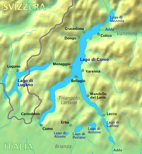
Elected 2006-05-28Area - Total 35.3 km2 (13.6 sq mi) Elevation 218 m (715 ft) Population (2010) - Total 7,498 - Density 212.4/km2 (550.1/sq mi) Demonym Colichesi Time zone CET (UTC+1) - Summer (DST) CEST (UTC+2) Postal code 23823 Dialing code 0341 Patron saint Saint George Saint day 23 April Website Official website Colico is a comune in the province of Lecco, Lombardy, Italy. It is situated near the tip of the northern arm of Lake Como, where the river Adda enters the lake. Colico, with an area of 35.3 km² and a population of about 7,200, is the most important town in the northern part of Lake Como, which is often identified as its Colico branch.
Colico is a local transport hub, with trains to Milan and boats to Como and Lecco, as well as road links south to Milan (via the eastern shore of the lake, Lecco and Brianza), north to Chiavenna, and east to Bolzano.
It is home to Piona Abbey.
Contents
Physical geography
Colico is located in the eastern part of Lake Como, dominated by the higher foothills, is an important part of the Colico landscape. Near Colico there is an important nature reserve, the migration corridor of the Pian di Spagna but it is mainly in the Province of Como. The two main waterways of Colico are Inganna and Perlino, and there is also the river Adda, which acts as a natural boundary to the Province of Como.
Monuments and places of interest
Forts
Fort Montecchio
See also: Fort MontecchioThe Forte Montecchio is the only Italian fort from World War I, which has been preserved intact with its original armament. It was built between 1911 and 1914. The main function of the fort was to control the streets of Spluga, of Maloja and Stelvio, in case the Central Powersdecided to violate the neutrality of Switzerland, and invade northern Italy.
The fort was one of the strongholds among a complex barrier system which extended up to Monte Legnone, though it remained inactive throughout the World War. The fort was never used in military actions even during the Second World War: the only gun shots which were fired at a German column that went along the opposite bank of the lake after the fort was occupied by the partisans. It was later used as a weapons depot and eventually transferred to the state property public.
Visitors of the fort can now observe the architectural, technical and organizational reasons, some of which are quite innovative for its time. The main attraction of the fort is still represented by the armament: four guns, with a range of 14 km, with installations in each well protected by a dome in iron. The fort, which recently has begun restoration work aimed at improving usability travel, is basically divided into two parts: the lower area that contains housing and powder magazines and the upper part of the host guns. The two areas are linked by a beautiful curved gallery.
Fort Fuentes
See also: Fort FuentesBetween 1603 and 1606, the count Fuentes, Governor of Milan, built a fort on Montecchio in order to defend the border north of Duchy of Milan from France and Swiss Graubünden, who at the time occupied Valtellina and Valchiavenna. The plan of the fort was oblong, with a horn works in the extremities, while the irregular walls, who came out and fell as wedges, allowed a better defense of the ramparts. The fort is spread over several levels: high, still visible, the building of the governor, but because the air was unhealthy, lived in Gravedona at the lowest quarters of the soldiers. The fort could house 300 men. The location of the stronghold allowed it to dominate the entire plain below, which by then was just called Pian di Spagna, but also allows the control of the road for Valtellina and Stelvio Pass for Valchiavenna and Splügen Pass, and, finally, Como and Milan. Even today the area is referred to as the Fuentes trivium.
To complete the Spanish defensive project were built two forts, one above Sorico, the other said Fortino d'Adda in Gera Lario and facing Valchiavenna. The fort was also connected to a series of outposts existing known by the generic name of towers. Despite the Fort Fuentes during the 17th and 18th century was a major fortification of Lombardy, there were no events of military note, only in 1706 during the War of Spanish Succession, the Fort was besieged for the first time since the Austrian who conquered it only after three weeks. In 1714 in Lombardy the Spanish domain was replaced by the Austrian: Fort Fuentes found itself involved in two other sieges in [[1733] ] by Spain and Piedmont, while the War of the Polish Succession and 1746 by the Spanish during the War of Austrian Succession.
In 1782, following the reform of the desired Emperor Joseph II of Austria, the fort was decommissioned and sold to private individuals. In 1796 at the behest of Napoleon, it was completely dismantled and then abandoned. Standing of the ancient fortress remain today only a few ruins, partly submerged by the vegetation, yet still rich in charm and interest.
The fresco removed from the chapel of the fort, a Santa Barbara patron of the gunners, the work is not particularly valuable, but of considerable historical importance, is now placed in the middle of the left side of the aisle parish church of Saint George in the centre of Colico.
Towers
Towers
Having been in past centuries the crossroads of major communication routes, the whole area was fortified at the age of Colico medieval of many fortification, even before the construction of the Fort Fuentes. On the northern Montecchio are still visible two guard towers, which formed the so-called Castle Colico era city, but largely reworked, to control road from Valtellina. More important from a strategic Fontanedo Tower, which was part of a more complex work of fortification built during the 14th century by Visconti. From the tower it was possible to dominate the Upper Lake, the hinterland of colic is the area of the Lake Mezzola. In defense of the ancient road linking the Lake Como with Valtellina within the territory of Curcio, there is another lookout tower, probably related to the Fort Fuentes has now been transformed into farm house and called the tower Curcio. Also for the defense of the fort had to be part so called Fortino d'Adda, or Stallone, who rises out of the border municipalities in the territory of Gera Lario. Was to serve as a protected activity for monitoring and storage. Its very unique structure that has slots for the shot of firearm and bridge brick that connects the main entrance to the plane. It is currently used for storage. A final fort is placed in the territory of Olgiasca. It is in this case a casaforte, which from the top of the hill controls the town below. It is known as the Castle of Mirabello and should have been built before the middle of 1500.
Roccoli
Real tree architectures, equipped with nets placed vertically, which surround a sort of stone tower from which you ran the hunting, the bird snares have long been formidable weapons catch the bird with a economic response to a territory, such as Colico place on route of the flocks, which, with the approaching cold season, migrating south. Of the many bird snares active until about forty years ago, are still well preserved in the town Piona and the place along the road that rises to the Fort Fuentes.
Places of worship
Abbey of Piona
See also: Piona AbbeyAmong the most famous romanic monuments of Lombardy Piona Abbey, which is one of the most beautiful convents in the area, both for the charm of natural environment, and for the presence of artistic purpose. The church, built in the mid-11th century, but subject to extension in the following century, has a front hut, with a large central window arch. The interior consists of a single aisle. At the entrance there are two Lions in marble regents fonts, but originally meant to support a column or a pulpit.
A note of interest the cycle painting, dating back to 13th century, of this apse: in the centre of the basin is the great figure of Christ, which supports a book open surrounded by four symbol of evangelist. Below are represented the twelve apostles in time, around the figure of Christ blessing with angels, we still shows the twelve apostles in groups of six, in a gesture of acclamation.
Behind the building of the church stands the ruins of an apse from the Medieval period, whose original purpose is uncertain. The bell outside, on the north side was constructed in the 18th century. The cloister is accessed to the right of the front through a portal with pointed arches, dating back to 13th century, a particularly impressive: along the perimeter of the courtyard run forty columns and four columns of marble, whose capitals, finely decorated with leaves, flowers and animals, support an upper floor with terracotta rings and bandsmarble red, white and black interspersed with elegant windows.
At the entrance of the cloister there is a fresco, dating from the 15th-16th century, depicting Christ's appearance to the Mary, while above the entrance of the arcade leading to the church is depicted a bust of Christ. On the porch, behind the church, in a simple style and the popular tone, there is a calendar fresco decorative element where there are few examples of singular throughout Europe. It is a long band divided into two registers: the upper one is represents the individual months through agricultural employment characteristics, September, for example, is characterized by the preparations of the Pops, July after beating wheat, the lower one is represented a series of eleven holy portrayed at the time of martyrdom. The fresco goes back to a time before the construction of the cloister and was originally located outside the church.
Church of San Rocco
The small church, originally named the Saints Fabian and Sebastian, stands outside the town on the slopes of Monte Legnone, almost midway between the course of the deception and Perlino at a height of five hundred meters. The plant is romanic, as evidenced by apse semicircular, but since 1401 underwent several changes. Preserved, especially in apse, traces of painting large enough, due to an unknown, but capable painter, which should have worked in the early 15th century. Particularly strong on the Christ in almond, or Almighty, and whose sides are the prophets Jeremiah and Isaiah. During a campaign restoration held in recent years, was found an interesting fresco depicting the Last Supper.
Villas
Villa Malpensata
The villa located in an isolated position on the shore of Lake, in places Olgiasca. The century plant, which incorporates a previous structure, it is very simple. The main facade is facing lake. Currently owned by Piona Abbey, is now headquarters of the Community "Il Gabbiano".
Villa Osio
The villa is located at the end of Via Lungolario Polti and forms the boundary to the shore. It is currently privately owned.
Culture
Media
Print
The main newspapers are those at the provincial level as La Gazzetta di Lecco or La Provincia di Lecco.
Cinema
Have not yet been produced films set in Colico.
Television
Teleunica is the main local TV of the province.
Events
The event more important is taking place in the stage Colico Italy is the World Cup of kitesurfing. Following the important festival classical music Musica sull'Acquathat takes place in Piazza Garibaldi and the Abbey of Piona. Also, please note theWhite Night of Colico along with dancing. Among the party the most important are the party of San Rocco on August 16 in homonym church.
Geography anthropic
Neighbourhoods
Centre
The centre is situated between Piazza Garibaldi, Via Vitali, Largo San Giorgio and Via Pontile. This district contains the main services of Colico. Between Via Municipio and Piazza Alpini there are City Hall, library, church of Saint George and the main schools. In Via Villatico there is the post office.
Lido
This district has a long beach, a field of soccer, tennis courts and a school of sailing.
Kitesurf
In the district there is a parking lot of RV, a beach and a school of surfing and kite.
Industrial Zone
The industrial zone is home to several factories and the landfill town.
Frazioni
Colico Piano
The village Colico Piano (old name Colicum) is the center of the country and the place of the Parish of S. Giorgio (patron saint's day on April 23), and dismembered by Villatico erected on 12/22/1914. The church built in the years 1925/1927, was consecrated September 24, 1978 by Bishop T. Ferraroni.
Villatico
See also: VillaticoThe village of Villatico (old name Vilarichum) hosts the Parish by S. Bernardino (patron saint's day May 20) that was built around 1500. The church dates from the second half of the century. XV (right after the canonization of San Bernardino, Others 1450).
Curcio
See also: CurcioIn Curcio (old name Curcium) there is an important natural source of water. Curcio is one of the villages of Colico in which the past is represented by the houses of a certain age and a public wash-house that was used in the past, here Dec. 3, 1934 was erected the Parish of Holy Guardian Angels (patron saint's day last Sunday in September) with territory dismembered from Villatico and Colico Piano. The first stone in 1938, the work of the new church began in 1946 and ended in 1957.
Laghetto
See also: LaghettoLaghetto (an old name Parvus lacus) is the union of two more places (Borgonuovo and Fiumarga) with a minor (the Court). In Laghetto there are many camping overlooking the lake of Piona. Former vice-curia communities, home of the Parish by Saint Fidelis of Como (patron saint's day last Sunday in October) which was only separated from Villatico 09/09/1857. The church was expanded in the years 1854/57 and restored in 1965/68. In 1957 the new bell tower was erected.
Olgiasca
See also: OlgiascaOlgiasca (old name Piona) is located in the homonymous peninsula. A Olgiasca is the Abbey of Piona and is home to the parish of Nicola of Bari (December 6 feast of the patron) becomes traces its erection in 1252 year, the continuing series of parish begins with 1693. A document dated 7/11/1593 speaks of the "Church parish priorities or Piona Abbey". Entrusted to the Cistercian monks.
Economy
The economy is mainly colichese travel, but industry gets a strong second place, the imposing industrial zone, always expanding, and there is also a large presence of bank. The tourism is mainly focused on the many camping. The industry boasts of leading brands of construction truck (Iveco) and yacht (Cranchi). Colico is full of bank thanks to its good location and large number of industrial establishments.
Infrastructure and Transport
Roads
Colico is connected to Milan by the SS 36 Milan - Lecco - Colico. Colico is the meeting point between the SS 36 and SS 38 of Stelvio through the Valtellina. In addition, the SS 36 goes through the Valchiavenna.
Railways
The station Colico is placed at the end of the first electrified line through a revolutionary phase method at 3000 volts made by the Hungarian firm Ganz from 1901, is a perfect architectural example of the stations built specifically for the line Sondrio - Colico. Between 1885 and 1886 Colico is connected with Sondrio and Chiavenna, but to see the operational link with Lecco (hence Milan) it was not until 1894. The line was then carried by the Adriatic Network, one of three major companies that remain in effect until 1905, year of birth of railways. The same style, even when applied to smaller, presents the station Piona. Colico, in his territory, has two stations.
Pier
There are two piers in Colico comune territory: Colico and Piona.
Twinning
 Wolfegg (Baden-Württemberg, Germany)
External links
 Media related to Colico at Wikimedia Commons
  Colico at Wikibooks
Frazioni Monuments Fort Fuentes · Fort Montecchio · Piona AbbeyEnvironment Lake Como · Monte Legnone · AddaSettlements Abbadia Lariana · Argegno · Bellagio · Bellano · Blevio · Brienno · Carate Urio · Cernobbio · Colico · Colonno · Como · Consiglio di Rumo · Cremia · Dervio · Domaso · Dongo · Dorio · Faggeto Lario · Gera Lario · Giulino · Gravedona · Griante · Laglio · Lecco · Lenno · Lezzeno · Lierna · Malgrate · Mandello del Lario · Menaggio · Mezzegra · Moltrasio · Musso · Nesso · Oliveto Lario · Ossuccio · Perledo · Pianello del Lario · Pognana Lario · Sala Comacina · San Siro · Sant'Abbondio · Santa Maria Rezzonico · Sorico · Torno · Tremezzo · Valbrona · Valmadrera · Varenna · Vercana

Islands Rivers Valleys Mountains Landmarks Villa del Balbianello · Villa Carlotta · Villa d'Este · Priorato di Piona · Castello di Vezio · Sacro Monte di OssuccioFilms People Categories:- Wikipedia articles needing cleanup after translation
- Cities and towns in Lombardy
- Communes of the Province of Lecco
- Colico


Wikimedia Foundation. 2010.