- Nateby, Cumbria
-
Coordinates: 54°27′20″N 2°20′58″W / 54.45542°N 2.3494°W
Nateby 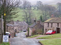
Nateby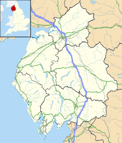
 Nateby
Nateby shown within CumbriaPopulation 110 (2001) OS grid reference NY774067 Parish Nateby District Eden Shire county Cumbria Region North West Country England Sovereign state United Kingdom Post town KIRKBY STEPHEN Postcode district CA17 Dialling code 01768 Police Cumbria Fire Cumbria Ambulance North West EU Parliament North West England UK Parliament Penrith and the Border List of places: UK • England • Cumbria Nateby is a village and civil parish in the Eden district of Cumbria, England. It is situated very near the town of Kirkby Stephen, near the River Eden, and on the borders of the Yorkshire Dales and North Yorkshire. Nearby are the Nine Standards Rigg hills. The village contains a popular country pub, The Black Bull Inn, a garage/petrol station and a small metal-yard, owned by families resident in the village.
A little over half a mile to the south-west, Wharton Hall, Wharton is a medieval fortified manor house, partly ruined and partly in use as a farmhouse.[1]
References
- ^ "Wharton Hall". britishlistedbuildings.co.uk. http://www.britishlistedbuildings.co.uk/en-73046-wharton-hall-wharton. Retrieved 2011-03-08.
External links
 Media related to Nateby, Cumbria at Wikimedia Commons
Ceremonial county of Cumbria Cumbria Portal Boroughs or districts City of Carlisle • Borough of Allerdale • Borough of Barrow-in-Furness • Borough of Copeland • District of Eden • District of South LakelandMajor settlements Alston • Ambleside • Appleby-in-Westmorland • Aspatria • Barrow-in-Furness • Bowness-on-Windermere • Brampton • Broughton-in-Furness • Carlisle • Cleator Moor • Cockermouth • Dalton-in-Furness • Egremont • Grange-over-Sands • Harrington • Kendal • Keswick • Kirkby Lonsdale • Kirkby Stephen • Longtown • Maryport • Millom • Penrith • Sedbergh • Silloth • Ulverston • Whitehaven • Wigton • Windermere • Workington
See also: List of civil parishes in CumbriaTopics Demography • Economy • Education • Geography • History • People • Places of interest • Settlements • Sport • Symbols and county emblems • TransportCategories:- Villages in Cumbria
- Civil parishes in Cumbria
- Cumbria geography stubs


Wikimedia Foundation. 2010.