- Newington, Shepway
-
- See Newington for other places of that name
Coordinates: 51°05′31″N 1°06′52″E / 51.092°N 1.1144°E
Newington 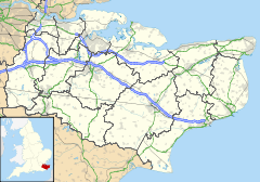
 Newington
Newington shown within KentPopulation 341 (parish, 2001 Census) District Shepway Shire county Kent Region South East Country England Sovereign state United Kingdom Police Kent Fire Kent Ambulance South East Coast EU Parliament South East England UK Parliament Folkestone and Hythe List of places: UK • England • Kent Newington is a village in Kent, England one mile (1.6km) west-north-west of Folkestone. It gives its name to Newington-Shepway Parish Council, which has five councillors[1], and includes the hamlets of Arpinge and Beachborough. The village lies to the north of the M20 motorway and the A20 road; the Channel Tunnel complex is nearby.
The ecclesiastical parish was known as Newington-next-Hythe, the latter town being 2½ miles (4km) to the south-west; the parish church is dedicated to St Nicholas[2]. Nearby there used to be a 13th-century Augustinian priory, founded in 1253 by Sir John Maunsell, who became a counsellor of King Henry III[3].
References
External links
 Media related to Newington, Shepway at Wikimedia Commons
Towns and villages in the Shepway district of Kent, England 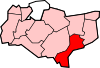 Acrise · Arpinge · Beachborough · Bladbean · Bodsham · Breach · Brenzett · Brookland · Burmarsh · Cheriton · Danton Pinch · Densole · Dymchurch · Dungeness · Elham · Elmsted · Etchinghill · Folkestone · Frogholt · Greatstone-on-Sea · Hawkinge · Hythe · Ivychurch · Lade · Littlestone-on-Sea · Lydd · Lydd-on-Sea · Lyminge · Lympne · Monks Horton · Newchurch · Newingreen · Newington · New Romney · Old Romney · Paddlesworth · Pedlinge · Peene · Postling · Rhodes Minnis · Saltwood · Sandgate · Sandling · Sellindge · Selsted · Snargate · Stanford · Stelling Minnis · St Mary in the Marsh · St Mary's Bay · Westenhanger · West Hythe · Wingmore
List of places in Kent Categories:- Villages in Kent
- Civil parishes in Kent
- Kent geography stubs


Wikimedia Foundation. 2010.