- Mason Lake
-
For the lake in West Virginia, see Pedlar Wildlife Management Area. For the lake in Washington's Snoqualmie Pass, see Mason Lake (King County).
Mason Lake 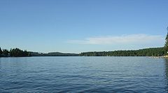
Location Mason County, Washington Coordinates 47°20′14″N 122°57′14.7″W / 47.33722°N 122.954083°WCoordinates: 47°20′14″N 122°57′14.7″W / 47.33722°N 122.954083°W Primary inflows Shumocher Creek Primary outflows Sherwood Creek Basin countries United States Max. length 4 mi (6.4 km) Max. width 0.75 mi (1.21 km) Surface area 1,000 acres (400 ha) Average depth 48 ft (15 m) Max. depth 90 ft (27 m) Shore length1 10.9 mi (17.5 km) Surface elevation 194 ft (59 m) Islands None 1 Shore length is not a well-defined measure. Mason Lake is a natural elongated lake south of Belfair, Washington, USA in Mason County. Named for Charles H. Mason, the first secretary of Washington Territory,[1] the lake is on the isthmus of the Kitsap Peninsula between the Hood Canal and Pickering Passage of the Case Inlet. The smaller Benson Lake is to its eastern side.
More than a thousand residents live yearlong around the shores of Mason Lake, the second largest freshwater lake in Mason County.
Originally a summer vacation community, the lake has always been known for its power boats, jet skis and water skiing. A county park provides swimming, picnic and boat launching access. The single lane boat launch is on the steeper side and winches tend to get jammed if they're in the locked or retrieval state.
The community of Mason Lake is located centrally between Grapeview and Harstine Island to the east, and Twanoh State Park to the west. Much of the area surrounding Mason Lake is commercial timberland in various states of harvest.
References
- ^ Majors, Harry M. (1975). Exploring Washington. Van Winkle Publishing Co. p. 68. ISBN 9780918664006. http://books.google.com/books?id=CoWrPQAACAAJ.
External links
- Profile of Mason Lake
- Mason Lake page of the official Mason County tourism website
- Mason/Benson Lake Community Club
Categories:- Lakes of Washington (state)
- Landforms of Mason County, Washington
- Washington (state) geography stubs

Wikimedia Foundation. 2010.