- Drakes Bay
-
For the bay in Costa Rica, see Drakes Bay, Costa Rica.
 Drakes Bay
Drakes Bay is a small bay on the coast of northern California in the United States, approximately 30 miles (48 km) northwest of San Francisco at approximately 38 degrees north latitude.[1] The bay is approximately 8 miles (13 km) wide. It is formed on the lee side of the coastal current by Point Reyes.
The bay is fed by Drake's Estero, an expansive estuary on the Point Reyes peninsula.
The bay is named after Sir Francis Drake and has long been considered Drake's most likely landing spot on the west coast of North America during his circumnavigation of the world by sea in 1579. An alternative name for this bay is Puerto De Los Reyes.[1]
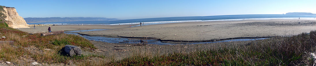 View of Drakes Bay from Drake's beach
See also
References
External links
- Shifting sandbars match Drake's descriptions of landing site
- Francis Drake: The Naming of Drakes Bay
Coordinates: 38°0′43″N 122°55′9″W / 38.01194°N 122.91917°W
West Marin Villages Bolinas • Dillon Beach • Dogtown • Inverness • Inverness Park • Lagunitas • Marshall • Millerton • Muir Beach • Nicasio • Olema • Pt. Reyes Station • Stinson Beach • TomalesGeography Audubon Canyon • Bolinas Lagoon • Bolinas Ridge • Bonita Channel • Centissima Reef • Copper Mine Gulch • Drakes Bay • Drakes Estero • Gull Rock • Pirates Cove • Point Reyes • Kent Island • Nicasio Creek • Nicasio Reservoir • Olema Valley • Rancho Punta de los Reyes Sobrante • Rodeo Lagoon • Rodeo Cove • Tennessee Cove • Tomales Bay • Sears RockParks and transportation Categories:- West Marin
- Bays of California
- Landforms of Marin County, California
- Landforms of the San Francisco Bay Area


Wikimedia Foundation. 2010.