- Antarctic Peninsula
-
 Antarctic Peninsula map.
 Location of Antarctic Peninsula within Antarctica.
The Antarctic Peninsula is the northernmost part of the mainland of Antarctica. It extends from a line between Cape Adams (Weddell Sea) and a point on the mainland south of Eklund Islands.
The Antarctic Peninsula is important because research has revealed that the forces of climate change are having a great effect on the region. The remote polar position has resulted in the area being dotted with numerous research stations and multiple claims of sovereignty. The peninsula forms part of disputed and overlapping claims by Argentina, Chile and the United Kingdom. None of these claims have international recognition and the respective countries do not currently actively pursue enforcement.
Contents
History
 Booth Island and Mount Scott flank the narrow Lemaire Channel on the west side of the Antarctic Peninsula.
 Off the coast of the Peninsula are numerous islands. Here is Webb Island and -behind it- Adelaide Island. Click on the picture for a detailed description of the other geographical features.
Discovery and naming
The first sighting of Antarctic Peninsula is disputed but apparently occurred in 1820. The most likely first sighting of the Antarctic mainland, which was also the Antarctic Peninsula, was probably during an expedition of the Russian Imperial Navy that was captained by Thaddeus von Bellinghausen. The party did not recognise what they thought was an icefield covered by small hillocks as the mainland on 27 January 1820.[1] Edward Bransfield and William Smith were the first to chart a part of the Antarctic Peninsula just three days later on the 30 January 1820. The location was later to be called Trinity Peninsula, the extreme northeast portion of the peninsula. The next confirmed sighting was by John Biscoe who named the northern part of the Antarctic Peninsula, Graham Land, in 1832.
The first to make landing on the continent is also disputed. A 19th century seal hunter called John Davis was almost certainly the first, however sealers were secretive about their movements and their ship logs were deliberately unreliable, in order to protect any new sealing grounds from competition.[1]
Between 1901 and 1904, Otto Nordenskiöld led the Swedish Antarctic Expedition, one of the first expeditions that was to explore parts of Antarctica.[1] They landed on the Antarctic Peninsula in February 1902, aboard the Antarctica which later sank not far from the peninsula with all crew saved. They were later rescued by an Argentine ship.[1] The British Graham Land Expedition between 1934 and 1937 carried out aerial surveys and concluded that Graham Land was not an archipelago but was a peninsula.
Agreement on the name Antarctic Peninsula by the US-ACAN and UK-APC in 1964 resolved a long-standing difference over the use of the American name "Palmer Peninsula" or the British name "Graham Land" for this feature.[2] (Graham Land is now that part of the Antarctic Peninsula northward of a line between Cape Jeremy and Cape Agassiz, whilst Palmer Land is the part southward of that line. Palmer Land is named for the American seal hunter, Nathaniel Palmer.) In Chile, the peninsula is officially referred as O'Higgins Land, after the Chilean patriot and Antarctic visionary. Other Spanish countries call it "Península Antártica", among them Argentina (while also calling it "Tierra de San Martín"), which has more bases and personnel there than any other nation.[citation needed]
Other portions of the peninsula that were named after various expeditions made their discovery include Bowman Coast, Black Coast, Danco Coast, Davis Coast, English Coast, Fallieres Coast, Loubet Land, Nordenskjold Coast and the Wilkins Coast.
See also: History of Antarctica and Voyage of the James CairdRecent
The RRS Bransfield was the name of the ship that transported the secret British expedition to Antarctica during World War Two, during which the first permanent British bases on the Antarctic Peninsula were established. Tourism to the Antarctic Peninsula begin in the 1950s. Most ship-based tourists depart for the peninsula from Puerto Williams in Chile.
Argentina's Esperanza Base was the birthplace of Emilio Marcos Palma, the first person to be born in Antarctica.[citation needed] The dinosaur species Antarctopelta was the first dinosaur fossil to be found on the continent, in January 1986 on James Ross Island, off the Antarctic Peninsula.[3]
The grounding of the Argentine ship Bahía Paraíso and subsequent 170,000 gallon oil spill occurred near the Antarctic Peninsula in 1989.[4][5] In 2005, Lewis Gordon Pugh broke the farthest-south long distance swim record by undertaking a 1 km (0.62 mi) swim at Petermann Island off the Antarctic Peninsula. In November 2007, the MS Explorer rammed submerged sea ice and then sank after water from a fist sized hole could not be pumped out quickly enough. All passengers and crew were safely evacuated and rescued.[6]
Geography
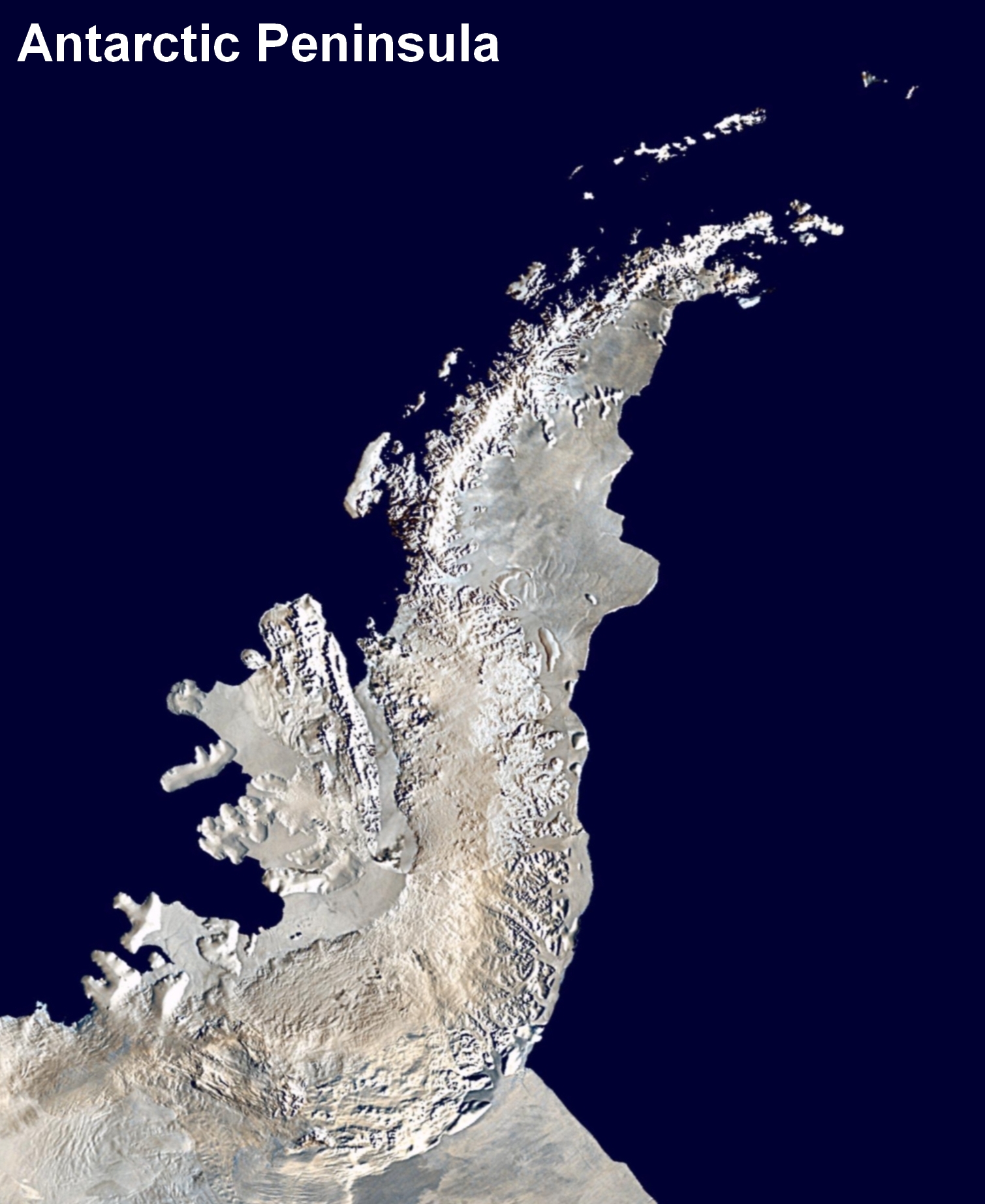
 Satellite image of Antarctic Peninsula.
 Nearly cloud-free view of the northern tip of the Antarctic Peninsula during Spring.
The peninsula is highly mountainous, its highest peaks rising to approximately 2,800 metres (9,186 ft). Notable peaks on the peninsula include Mount Castro, Mount Coman, Mount Gilbert, Mount Jackson, Mount William, Mount Owen and Mount Scott. These mountains are considered to be a continuation of the Andes of South America, with a submarine spine or ridge connecting the two.[7] This is the basis for the position advanced by Chile and Argentina for their territorial claims. The Scotia Arc is the island arc system that links the mountains of the Antarctic Peninsula to those of Tierra del Fuego.
The landscape of the peninsula is typical Antarctic tundra. The peninsula has a sharp elevation gradient, with glaciers flowing into the Larsen Ice Shelf, which experienced significant breakup in 2002. Other ice shelves on the peninsular include George VI Ice Shelf, Wilkins Ice Shelf, Wordie Ice Shelf and the Bach Ice Shelf. The Filchner-Ronne Ice Shelf lies to the east of the peninsula.
Islands along the peninsula are mostly ice covered and connected to the land by pack ice.[8] Separating the peninsula from nearby islands is the Antarctic Sound, Erebus and Terror Gulf, George VI Sound, Gerlache Strait and the Lemaire Channel. The Lemaire Channel is a popular destination for tourist cruise ships that visit Antactica. Further to the west lies the Bellingshausen Sea and in the north is the Scotia Sea. The Antarctic Peninsula and Cape Horn create a funneling effect, which channels the winds into the relatively narrow Drake Passage.[citation needed]
Hope Bay, at 63°23′S 057°00′W / 63.383°S 57°W, is near to the northernmost extremity of the peninsula, which is Prime Head, at 63º13'S. Near the tip at Hope Bay is Sheppard Point. The part of the Antarctic Peninsula extending northeastwards from a line connecting Cape Kater to Cape Longing is called the Trinity Peninsula. Brown Bluff is a rare tuya and Sheppard Nunatak is found here also. The Airy Glacier, Seller Glacier, Fleming Glacier and Prospect Glaciers form the Forster Ice Piedmont along the west coast of the Antarctic Peninsula. Charlotte Bay, Hughes Bay and Marguerite Bay are located on the west coast as well.
On the east coast is the Athene Glacier while the Arctowski Nunatak and Akerlundh Nunatak are both located just off the east coast. A number of smaller peninsulas extend from the main Antarctic Peninsula including Hollick-Kenyon Peninsula and Prehn Peninsula at the base of the Antarctic Peninsula. Also located here are the Scaife Mountains. The Eternity Range is found in the middle of the peninsula. Other geographical features include Avery Plateau, the twin towers of Una's Tits.
Climate change
Further information: Climate of Antarctica An iceberg adrift off the coast of the peninsula.
The Antarctic Peninsula is a part of the world that is experiencing extraordinary warming.[9] Each decade for the last five, average temperatures in the Antarctic Peninsula have risen by half a degree Celsius.[10] Ice mass loss on the peninsula occurred at a rate of 60 billion tonnes in 2006,[11] with the greatest change occurring in the northern tip of the peninsula.[12] Seven ice shelves along the Antarctic Peninsula have retreated or disintegrated in the last two decades.[9] Research by the United States Geological Survey has revealed that every ice front on the southern half of the peninsula experienced a retreat between 1947 and 2009.[13] According to a study by the British Antarctic Survey, glaciers on the peninsula are not only retreating but also increasing their flow rate as a result of increased buoyancy in the lower parts of the glaciers.[14] Professor David Vaughan has described the disintegration of the Wilkins Ice Shelf as the latest evidence of rapid warming in the area.[15] The Intergovernmental Panel on Climate Change has been unable to determine the greatest potential effect on sea level rise that glaciers in the region may cause.[14]
See also: Antarctica cooling controversy and Retreat of glaciers since 1850Research stations
 Research vessel at the wharf of Rothera Research Station.
The 1950s saw a marked increase in the number of research bases as Britain, Chile and Argentina competed to make claims over the same area.[16] Meteorology and geology were the primary research subjects.
Since the peninsula has the mildest climate in Antarctica, the highest concentration of research stations on the continent can be found there, or on the many nearby islands, and it is the part of Antarctica most often visited by tour vessels and yachts. Occupied bases include Base General Bernardo O'Higgins Riquelme, Bellingshausen Station, Comandante Ferraz Brazilian Antarctic Base, Rothera Research Station and San Martín Base. Today, on the Antarctic Peninsula there are many abandoned scientific and military bases. Ice core and sediment samples from the peninsula are valuable because events such as the Little Ice Age can be verified with samples from other continents.
Flora and fauna
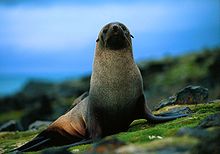 The Antarctic Fur Seal, once reduced to a small population on South Georgia after being hunted towards extinction, has returned to the waters around the Antarctic Peninsula.
Antarctica is not just snow and ice, indeed fossil evidence of ancient plants shows that it was once joined to the other continents as part of the supercontinent, Gondwana. The coasts of the peninsula have the mildest climate in Antarctica and moss and lichen-covered rocks are free of snow during the summer months, although the weather is still intensely cold and the growing season very short. The plant life today is mainly mosses, lichens and algae adapted to this harsh environment, with lichens preferring the wetter areas of the rocky landscape. The most common lichens are Usnea and Bryoria species. Antarctica's two flowering plant species, the Antarctic hair grass (Deschampsia antarctica) and Antarctic pearlwort (Colobanthus quitensis) are found on the northern and western parts of the Antarctic Peninsula, including offshore islands, where the climate is relatively mild.[17] Lagotellerie Island in Marguerite Bay is an example of this habitat.
Antarctic krill are found in the seas surrounding the peninsula and the rest of the continent. The Crabeater Seal spends most of its life in the same waters feeding on krill. Bald notothen is a cryopelagic fish that lives in sub-zero water temperatures around the peninsula. Vocalizations of the Sei Whale can be heard emanating from the waters surrounding the Antarctic Peninsula.[citation needed]
The animals of Antarctica live on food they find in the sea not on land and include seabirds, seals and penguins. The seals include: Leopard Seal (Hydrurga leptonyx), Weddell Seal (Leptonychotes weddellii), the huge Southern Elephant Seal (Mirounga leonina), and Crabeater Seal (Lobodon carcinophagus).
Penguin species found on the peninsula, especially near the tip and surrounding islands, include the Chinstrap Penguin, Emperor Penguin, Gentoo penguin and the Adelie Penguin. Petermann Island is the world's southernmost colony of Gentoo Penguins. The exposed rocks on the island is one of many locations on the peninsula that provides a good habitat for rookeries.[citation needed] The penguins return each year and may reach populations of more than ten thousand. Of these the most common on the Antarctic Peninsula are the chinstrap and gentoo, with the only breeding colony of Emperor Penguins in West Antarctica an isolated population on the Dion Islands, in Marguerite Bay on the west coast of the peninsula. Most emperor penguins breed in East Antarctica.[18]
Seabirds of the Southern Ocean and West Antarctica found on the peninsula include: Southern Fulmar (Fulmarus glacialoides), the scavenging Southern Giant Petrel (Macronectes giganteus), Cape Petrel (Daption capense), Snow Petrel (Pagodroma nivea), the small Wilson's Storm-petrel (Oceanites oceanicus), Imperial Shag (Phalacrocorax atriceps), Snowy Sheathbill (Chionis alba), the large South Polar Skua (Catharacta maccormicki), Brown Skua (Catharacta lönnbergi), Kelp Gull (Larus dominicanus), and Antarctic Tern (Sterna vittata). The Imperial Shag is a cormorant which is native to many sub-Antarctic islands, the Antarctic Peninsula and southern South America.
Threats and preservation
Although this very remote part of the world has never been inhabited and is protected by the Antarctic Treaty System, which bans industrial development, waste disposal and nuclear testing, there is still a threat to these fragile ecosystems from increasing tourism, primarily on cruises across the Southern Ocean from the port of Ushuaia, Argentina.
See also
- Argentine actions in Antarctica
- Argentina-Chile relations#Border issues
- Bransfield Strait
- Geology of the Antarctic Peninsula
References
- ^ a b c d Scott, Keith (1993). The Australian Geographic book of Antarctica. Terrey Hills, New South Wales: Australian Geographic. pp. 114—118. ISBN 1862760101.
- ^ U.S. Geological Survey Geographic Names Information System: Antarctic Peninsula
- ^ "Fossils found in Antarctica". Toledo Blade. AP: p. 27. 20 November 1986. http://news.google.com/newspapers?id=1UVPAAAAIBAJ&sjid=HgMEAAAAIBAJ&pg=7012,6826038. Retrieved 2011-01-30.
- ^ "The world's frozen clean room". Business Week. 22 January 1990.
- ^ Smith, James F. (5 April 1990). "Struggling to Protect 'The Ice'". Los Angeles Times. http://articles.latimes.com/1990-04-05/news/mn-986_1_scientific-research. Retrieved 2011-01-30.
- ^ "Stricken Antarctic ship evacuated". British Broadcasting Corporation. 24 November 2007. http://news.bbc.co.uk/2/hi/americas/7108835.stm. Retrieved 2009-07-22.
- ^ "Operation IceBridge Returns to Antarctica". Earth Observatory. NASA. October 15, 2011. http://earthobservatory.nasa.gov/IOTD/view.php?id=76149. Retrieved 15 Octocber 2011.
- ^ Tulloch, Coral (2003). Antarctica: Heart of the World. Sydney: ABC Books. pp. 40. ISBN 0733309127.
- ^ a b "Even The Antarctic Winter Cannot Protect Wilkins Ice Shelf". Science Daily. 14 June 2008. http://www.sciencedaily.com/releases/2008/06/080613104743.htm. Retrieved 2008-06-18.
- ^ "Satellites Shed Light On Global Warming". TerraDaily.com. 29 April 2007. http://www.terradaily.com/reports/Satellites_Shed_Light_On_Global_Warming_999.html. Retrieved 2011-01-30.
- ^ "Antarctic Ice Loss". TerraDaily.com. 14 January 2008. http://www.terradaily.com/reports/Antarctic_Ice_Loss_999.html. Retrieved 2008-03-29.
- ^ "Antarctic Heating and Cooling Trends". Goddard Space Flight Center. NASA. http://svs.gsfc.nasa.gov/vis/a000000/a003100/a003188/index.html. Retrieved 2008-03-29.
- ^ "Ice shelves disappearing on Antarctic Peninsula". PhysOrg.com. 22 February 2010. http://www.physorg.com/news186068531.html. Retrieved 23 February 2010.
- ^ a b "Hundreds Of Antarctic Peninsula Glaciers Accelerating As Climate Warms". Science Daily. 6 June 2007. http://www.sciencedaily.com/releases/2007/06/070605121037.htm. Retrieved 2008-07-09.
- ^ "Wilkins Ice Shelf hanging by its last thread". European Space Agency. 10 July 2008. http://www.esa.int/esaCP/SEM2U5THKHF_index_0.html. Retrieved 2008-08-08.
- ^ Thomson, Michael; Charles Swithinbank (1 August 1985). "The prospects for Antarctic Minerals". New Scientist (1467): 31–35.
- ^ Scott, Keith (1993). The Australian Geographic book of Antarctica. Terrey Hills, New South Wales: Australian Geographic. pp. 107. ISBN 1862760101.
- ^ "Terrestrial Ecoregions -- Marielandia Antarctic tundra". World Wildlife Fund. 2001. http://www.worldwildlife.org/wildworld/profiles/terrestrial/an/an1101_full.html.
External links
- "Of Ice and Men" Account of a tourist visit to the Antarctic Peninsula by Roderick Eime
- Biodiversity at Ardley Island, South Shetland archipelago, Antarctic Peninsula
- 89 photos of the Antarctic Peninsula
Antarctica Main articles - Antarctic
- History
- Geography
- Climate
- Expeditions
- Research stations
- Field camps
- Territorial claims
- Antarctic Treaty System
- Telecommunications
- Demographics
- Economy
- Tourism
- Transport
- Military activity in the Antarctic
Geographic regions - Antarctic Peninsula
- East Antarctica
- West Antarctica
- Extreme points of the Antarctic
- List of Antarctic and subantarctic islands
- Antarctica ecozone
Waterways Famous explorers  Portal:AntarcticaCategories:
- Geography of the Antarctic Peninsula
- Argentine Antarctica
- British Antarctic Territory
- Peninsulas of Antarctica
- West Antarctica
- Chilean Antarctica
- Tundra
- Antarctic ecozone


Wikimedia Foundation. 2010.