Dimitrios Ypsilantis (municipality)
- Dimitrios Ypsilantis (municipality)
-
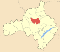
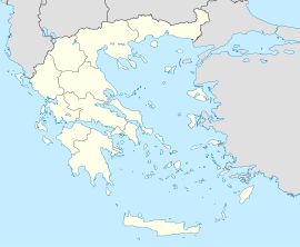
Dimitrios Ypsilantis (Greek: Δημήτριος Υψηλάντης) is a former municipality in Kozani peripheral unit, West Macedonia, Greece. Since the 2011 local government reform it is part of the municipality Kozani, of which it is a municipal unit.[1] It was named after Demetrius Ypsilanti, a 19th century leader of the Greek struggle for independence. Population 3,018 (2001). The seat of the municipality was in Mavrodendri.
References
- ^ Kallikratis law Greece Ministry of Interior (Greek)
| v · d · eSubdivisions of the municipality of Kozani |
|
| Municipal unit of Aiani |
|
|
| Municipal unit of Dimitrios Ypsilantis |
|
|
| Municipal unit of Elimeia |
Amygdalea · Ano Komi · Kaisareia · Kato Komi · Kontovouni · Krokos · Milea · Sparto |
|
| Municipal unit of Ellispontos |
Agios Charalampos · Agios Dimitrios · Akrini · Avgi · Drepano · Kapnochori · Kleitos · Koilada · Polymylos · Ryaki · Tetralofo · Voskochori |
|
| Municipal unit of Kozani |
|
|
Categories:
- Populated places in Kozani (peripheral unit)
- West Macedonia geography stubs
Wikimedia Foundation.
2010.
Look at other dictionaries:
Mavrodendri — (English: Black Tree) is a small town in Kozani peripheral unit, Greece. It is situated some 8 km east of Kozani on the road to Florina. Mavrodendri was the seat of the municipality Dimitrios Ypsilantis. The postal code is 50200, and the… … Wikipedia
List of postal codes in Greece — The Greek postal code system is is administered by ELTA (Ελληνικά Ταχυδρομεία, Hellenic Post). Each city street or rural region has a unique five digit number. The first three digits identify the city, municipality or prefecture. In major cities … Wikipedia
Georgios Lassanis — ( el. Γεώργιος Λασσάνης) (1793 1870) was a scholar and politician from Kozani, Greece. He studied literature and philosophy in Leipzig, then, in 1818, moved to Odessa, where he taught at the Greek community s business school. In Russia he became… … Wikipedia
Nea Charavgi — (Greek: Νέα Χαραυγή) is a Municipal Department of the city of Kozani, located 5 km east of the center near the municipal park Kouri. The population of Nea Charavgi is 1,253. The public corporation of electricity moved the village to its present… … Wikipedia
Nea Nikopoli — Location in Kozani Nea Nikopoli (Greek: Νέα Νικόπολη) is a municipal department of the city of Kozani in northern Greece. Located north west of the city centre, it has a population of 215 … Wikipedia
Metamorfosi, Kozani — Location in Kozani Metamorfosi is a municipal department of the city of Kozani in northern Greece. Located southwest of the city centre, it has a population of 444 … Wikipedia
Chromio — is a community located in Aiani municipal unit, Kozani peripheral unit, in the Greek region of Macedonia. It is situated at an altitude of 640 meters above sea level. The postal code is 50004, while the telephone code is +30 24610. As of the 1991 … Wikipedia
Oinoi, Kozani — Location in Kozani Oinoi (Greek: Οινόη) is a municipal department of the city of Kozani in northern Greece. Located east of the city centre, it has a population of 147 … Wikipedia
Rigas Feraios — Rigas Ρήγας Φεραίος Rigas Born Antonios Kyriazis 1757 Velestino (now Rigas Feraios (municipality)), Thessaly, Greece (then in the Ottoman Empire) … Wikipedia
Papaflessas — For the Greek municipality, see Papaflessas, Messenia. Papaflessas (Grigorios Dikaios). Papaflessas (Παπαφλέσσας; 1788 – 1825), born Grigorios Demetrios Flessas (Γρηγόριος Δημητρίου Φλέσσας), was a Greek patriot, priest, and government official… … Wikipedia
 Dimitrios Ypsilantis