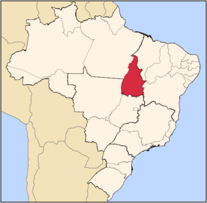
- Tocantins (state)
Infobox Brazilian State
name = State of Tocantins
motto =
anthem =
capital = Palmas
latd= |latm= |latNS= |longd= |longm= |longEW=
largest_city = Palmas
demonym = Tocantinense
leader_name1 = Marcelo Miranda
leader_name2 = Paulo Sidnei Antunes
area = 277.620,91
area_magnitude = 1 E11
area_rank = 10th
population_estimate = 1,332,441
population_estimate_rank = 24th
population_estimate_year = 2006
population_census = 1,307,818
population_census_year = 2005
population_density = 4.8
population_density_rank = 22th
GDP = R$ 9,084,000,000
GDP_rank = 24th
GDP_year = 2005
GDP_per_capita = R$ 6,957
GDP_per_capita_rank = 16th
HDI = 0.756
HDI_rank = 14th
HDI_year = 2005
abbreviation = BR-TO
time_zone = BRT
utc_offset = -3
time_zone_DST = BRST
utc_offset_DST = -2Tocantins (pronounced|tokɐ̃ˈtĩs [The presented pronunciation is in
Brazilian Portuguese variant spoken in Tocantins (and most of Brazil). Other possible pronunciations are: IPA| [tokɐ̃ˈtʃĩs] (most of Southeast, except São Paulo), IPA| [tokɐ̃ˈtsĩs] (São Paulo). TheEuropean Portuguese pronunciation is IPA| [tokɐ̃ˈtĩʃ] .] ) is one of the states ofBrazil .The state was formed in 1988 out of the northern part ofGoiás , and construction began on the capital, Palmas, in 1989, in contrast to most of the other cities in the state which date back to Portuguese colonial period. It is the newest Brazilian State and, because it is still very young, it is developing slowly, building on its most important resources: theriver s Araguaia and Tocantins, the largest hydro basin entirely inside Brazilian territory. Because it is in the central zone of the country, it has characteristics of the Amazon, but also has open pastures. TheIlha do Bananal , in the southwest of the State, is the largest fluvial isle in the world. There is the National Park of Araguaia, and the Carajás Indian reservations. Another highlight is the Jalapão, about 250 kilometers from the capital,Palmas . There, theriver s create trueoases in the dry landscape, attracting many eco-tourists to the region.Geography
Tocantins forms the boundary between the
Amazon Rainforest and the coastalsavanna . As a result, the state's geography is varied. Manyriver s cross through the state (including one of the same name), and there are over 20 archaeologically significant sites found in Tocantins.Climate
An
equatorial climate is a type oftropical climate in which there is nodry season – all months have meanprecipitation values of at least 60mm. It is usually found atlatitude s within five degrees of theequator – which are dominated by theIntertropical Convergence Zone . The equatorial climate is denoted "Af" in theKöppen climate classification .Tropical rainforest is the natural vegetation in equatorial regions.Vegetation
The Amazon represents over half of the planet's remaining
rainforest s and comprises the largest and most species-rich tract oftropical rainforest in theworld . Wet tropical forests are the most species-richbiome , and tropical forests in theAmericas are consistently more species rich than the wet forests inAfrica andAsia .Turner, I.M. 2001. "The ecology of trees in the tropical rain forest".Cambridge University Press , Cambridge. ISBN 0-521-80183-4] As the largest tract of tropical rainforest in the Americas, the Amazonian rainforests have unparalleledbiodiversity . More than 1/3 of all species in the world live in the Amazon Rainforest. [ [http://www.worldwildlife.org/wildplaces/amazon/index.cfm Amazon Rainforest, Amazon Plants, Amazon River Animals] ]History
What is today Tocantins state was first explored by Jesuit missionaries in about 1625, seeking to convert the
Amerindian peoples of the area toChristianity . The area is named after the Tocantins River, which in turn is an indigenous name.Before 1988 the area was part of the Goiás state, in the north of the state. However, ever since the 1600s, the north has been isolated and difficult to access. As a result, the southern area of the state became more developed, and there had been a strong separatist movement in the north for many years.
The first large scale stirrings of separatism were in 1809, when heavy
tax es were levied onmining . This led to a minorrevolt which was quickly crushed by the army. A string of failed uprisings occurred in the 19th century.In the 1970s, pressure was put on the federal government by the northern Goiás population for a separate state, and in the 1988 Constitution, Tocantins state was officially created.
Since its establishment, Tocantins is the fastest-growing Brazilian state, with a thriving economy based on agriculture and agro-industry which attracts immigrants from all over the country. The construction of the long-planned
North-South Railway (Brazil) will probably boost the economic growth even more. Tocantins is also considered one of the best-managed Brazilian states.Demographics
According to the
IBGE of 2007, there were 1,377,000 people residing in the state. The population density was 4.8 inh./km².Urbanization : 71.5% (2004);Population growth : 2.6% (1991-2000);House s: 355,502 (2005). [Source: PNAD.]The last PNAD (National Research for Sample of Domiciles) census revealed the following numbers: 948,000
Pardo (Brown) people (68.9%), 330,000 White people (24.0%), 95,000 Black people (6.9%), 2,000 Asian or Amerindian people (0.2%). [cite book |url=ftp://ftp.ibge.gov.br/Indicadores_Sociais/Sintese_de_Indicadores_Sociais_2007/Tabelas |title=Síntese de Indicadores Sociais 2007 |publisher=IBGE |location=Tocantins, Brazil |format=PDF |isbn=85-240-3919-1 |accessdate=2007-07-18 |year=2007 |language=Portuguese]Interesting facts
Vehicles : 259,890 (March/2007);Mobile phone s: 543 thousand (April/2007);Telephone s: 166 thousand (April/2007);Cities : 136 (2007). [Source:IBGE .]Economy
The
service sector is the largest component ofGDP at 59.9%, followed by theindustrial sector at 27.2%.Agriculture represents 12.9% ofGDP (2004). Tocantins exports:soybean 89.2%,meat ofcattle 10.5% (2002).Share of the Brazilian economy: 0.4% (2005).
As with much of Brazil, Tocantins' economy is dependent on
cattle raising, though the state'spineapple plantation s not only supply much of Brazil with thefruit , but also many otherMercosul nations with it too. In the state's north,charcoal and oils are extracted from the babaçupalm tree .The federal government, seeking to broaden Tocantins' economic base by funding the construction of a
hydroelectric dam in the state, allowed a private company to construct a sizable five-turbine hydroelectric dam, blocking the Tocantins river and displacing some indigenous inhabitants. However, its contribution to the state is indisputable - one turbine alone powers the entire state of Tocantins while the remaining four provide electricity which is sold to other parts ofBrazil .Education
Portuguese is the official national language, and thus the primary language taught in schools. But English and Spanish are part of the official
high school curriculum.Educational institutions
* Universidade Federal do Tocantins (UFT) (Federal University of Tocantins);
* Fundação Universidade do Tocantins (Unitins) (Foundation University of Tocantins);
* Escola Técnica Federal de Palmas (ETF-TO);
* Faculdade de Tecnologia de Palmas (FTP);
* Fundação Unirg (Unirg) (Foundation Unirg);
* and many others.Infrastructure
National Airport
The facility occupies one of
Brazil ’s largest airport sites and has privileged location near the Lageado Hydroelectric Station.Designed with a modern concept of visual communication, the new Palmas Airport Complex contains an Aeroshopping area, a program developed by Infraero aiming to turn Brazil’s main airports into true commercial centers with their own brand and identity.The passenger terminal has 12.300 square meters of constructed area and capacity to serve up to 370 thousand people a year. It has a food court, cultural space,shop s, panoramic deck, elevators and air conditioning. The runway can receive aircraft the size of a Boeing 767. There are three taxiways and aprons for general aviation, making operations more flexible. The airport has full infrastructure that includes a control tower and installations for the Air Navigation Group, fire brigade, a covered equipment parking area, canteen and training rooms, two aircraft fueling stations, a gate with electronic entry control, guard booths. parking and flight protection buildings, besides a 4 km (2.48 mi) access road linking the airport to the Tocantins capital city’s main thoroughfare.Highways
BR-153,BR-010,BR-226,BR-230,BR-235,BR-242,TO-348,TO-164.
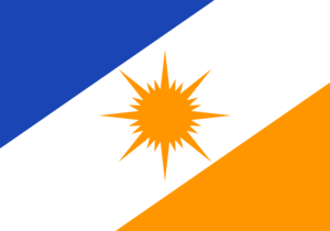
Flag
The message of the flag is the phrase "where the sun rises for all". In the middle of the flag is the golden yellow sun, with its rays symbolically targeting to the future of the state. The sun is placed on a white band, where the white color represents peace. The blue in the upper left and the yellow in the bottom right represent the waters and the soil of the state. The colors date back to a flag used by the Autonomous Government of Palmas in the 19th century.
The flag was adopted with the state flag law (law no 094/89) of
November 17 1989 .Cities
Other cities include:
*Tocantinópolis
*Colinas do Tocantins
*Araguaína
*Gurupi
* Palmas
*Taquarussu do Porto
*Porto Nacional References
See also
*
Brazil
* [http://www.to.gov.br Official Website]
* [http://www.braziltour.com/site/gb/home/index.php Brazilian Tourism Portal]
*List of cities in Brazil (all cities and municipalities)


Wikimedia Foundation. 2010.