- Pennsylvania Route 352
-
PA Route 352
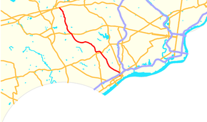
Route information Maintained by PennDOT Length: 18.58 mi[1] (29.90 km) Existed: 1928 – present Major junctions South end:  US 13 in Chester
 US 1 in Middletown Township
 PA 3 in Westtown Township
North end:  US 30 in East Whiteland Township
Location Counties: Delaware, Chester Highway system Roads in Pennsylvania
Interstate • US • State • Legislative←  PA 351
PA 353  →
→Pennsylvania Route 352 is a 19-mile (31 km) north–south route that begins at U.S. Route 13 in Chester and ends at U.S. Route 30 in Malvern. It is known as Middletown Road between Pennsylvania Route 452 and Pennsylvania Route 926,[2] with the route north of Route 926 called Chester Road.[3]
Contents
Route description
Delaware County
A few blocks from the Delaware River, PA 352 begins at an intersection with U.S. Route 13. Route 352 is closely parallel to Route 320 while going north out of Chester.[4] It is designated the Avenue of the States in the city, however it becomes Edgmont Avenue in Upland.[5]
Now out of Chester, PA 352 heads north as New Middletown Road, overpassing the Media/Elwyn Line's western terminus, at Elwyn.[6] After that, Route 352 interchanges an at-grade portion of U.S. Route 1, then makes a sharp turn to the left and intersects the northern terminus of Pennsylvania Route 452.[7]
After that last intersection, Route 352 is designated Middletown Road.[8] In Middletown, Edgmont, and Thornbury Townships, PA 352 maintains a northwest–southeast course as it traverses the township until intersecting with Pennsylvania Route 926.[2] Route 926 serves as the county line for Delaware and Chester counties,[4][9] for which at this point Newton Road becomes Chester Road.[3]
Chester County
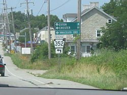 The northern terminus of PA 352 at U.S. Route 30 (Lancaster Avenue).
Route 352 enters Chester County in Westtown Township after an intersection with Route 926.[9] Immediately after that, Route 3 meets up with PA 352,[10] forming a 1 block concurrency.[1]
After leaving PA 3, Route 352 is on its signed north–south course again, not having any major intersections. It is still designated Chester Road until intersecting a side street called King Road, where it becomes Sproul Road.[11] It then continues northward for a short while, crosses over two railroads, and ends at U.S. Route 30.[12]
History
In 1911, when the Sproul Road Bill was passed, Legislative Route 132 was designated on current PA 352 between Chester and Media, while LR 179 got the part between Media and East Goshen Township.[13]
Route 352 crossed Route 3 at one time but traffic was diverted 1 block east onto Route 3.Major intersections
County Location Mile[1] Destinations Notes Delaware Chester 0.00 US 13 (9th Street)Middletown Township 5.76 US 1 (Baltimore Pike)Interchange. Lima 6.70  PA 452 (Pennell Road)
Northern terminus of PA 452. Thornbury–Westtown township line 11.60  PA 926 (Street Road)
County line Chester Westtown Township 11.84 PA 3 east (West Chester Pike)South end of PA 3 concurrency 12.98 PA 3 west (West Chester Pike)North end of PA 3 concurrency East Whiteland Township 18.58 US 30 (Lancaster Avenue)1.000 mi = 1.609 km; 1.000 km = 0.621 mi References
- ^ a b c DeLorme Street Atlas USA 2007, Toggle Measure Tool. Retrieved on 2007-07-06.
- ^ a b Google, Inc. Google Maps – Parts of PA 352 designated as Middletown Road (Map). Cartography by Google, Inc. http://maps.google.com/maps?client=firefox-a&ie=UTF8&oe=UTF-8&hl=en&channel=s&q=&ll=39.92672,-75.467148&spn=0.088594,0.160675&z=13&om=1. Retrieved 2007-07-06.
- ^ a b Google, Inc. Google Maps – PA 352 designated as Chester Road (Map). Cartography by Google, Inc. http://maps.google.com/maps?client=firefox-a&ie=UTF8&oe=UTF-8&hl=en&channel=s&q=&ll=40.001846,-75.543194&spn=0.088497,0.160675&z=13&om=1. Retrieved 2007-07-06.
- ^ a b Pennsylvania Department of Transportation (2007). Delaware County (Map). ftp://ftp.dot.state.pa.us/public/pdf/BPR_pdf_files/MAPS/GHS/Roadnames/delaware_GHSN.pdf. Retrieved 2007-07-06.
- ^ Google, Inc. Google Maps – PA 352 in suburban Chester (Map). Cartography by Google, Inc. http://maps.google.com/maps?client=firefox-a&ie=UTF8&oe=UTF-8&hl=en&channel=s&q=&ll=39.863042,-75.372562&spn=0.022169,0.040169&z=15&om=1. Retrieved 2007-07-06.
- ^ Google, Inc. Google Maps – PA 352 at Elwyn Station (Map). Cartography by Google, Inc. http://maps.google.com/maps?client=firefox-a&ie=UTF8&oe=UTF-8&hl=en&channel=s&q=&ll=39.906839,-75.413289&spn=0.022155,0.040169&z=15&om=1. Retrieved 2007-07-06.
- ^ Google, Inc. Google Maps – PA 352 in Middletown Township (Map). Cartography by Google, Inc. http://maps.google.com/maps?client=firefox-a&ie=UTF8&oe=UTF-8&hl=en&channel=s&q=&ll=39.916385,-75.430112&spn=0.022152,0.040169&z=15&om=1. Retrieved 2007-07-06.
- ^ Google, Inc. Google Maps – PA 352 and 452 (Map). Cartography by Google, Inc. http://maps.google.com/maps?client=firefox-a&ie=UTF8&oe=UTF-8&hl=en&channel=s&q=&ll=39.925469,-75.444875&spn=0.022149,0.040169&z=15&om=1. Retrieved 2007-07-06.
- ^ a b Pennsylvania Department of Transportation (2007). Chester County (Map). ftp://ftp.dot.state.pa.us/public/pdf/BPR_pdf_files/MAPS/GHS/Roadnames/chester_GHSN.pdf. Retrieved 2007-07-06.
- ^ Google, Inc. Google Maps – PA 352 and 3 (Map). Cartography by Google, Inc. http://maps.google.com/maps?client=firefox-a&ie=UTF8&oe=UTF-8&hl=en&channel=s&q=&ll=39.964622,-75.519247&spn=0.044273,0.080338&z=14&om=1. Retrieved 2007-07-06.
- ^ Google, Inc. Google Maps – PA 352 from Chester Road to Sproul Road (Map). Cartography by Google, Inc. http://maps.google.com/maps?client=firefox-a&ie=UTF8&oe=UTF-8&hl=en&channel=s&q=&ll=40.026629,-75.549502&spn=0.011058,0.020084&z=16&om=1. Retrieved 2007-07-06.
- ^ Google, Inc. Google Maps – PA 352 at US 30 (Map). Cartography by Google, Inc. http://maps.google.com/maps?client=firefox-a&ie=UTF8&oe=UTF-8&hl=en&channel=s&q=&ll=40.036651,-75.555124&spn=0.022113,0.040169&z=15&om=1. Retrieved 2007-07-06.
- ^ Pennsylvania Department of Transportation (1911). Sproul Road Bill (Map). ftp://ftp.dot.state.pa.us/public/pdf/BPR_pdf_files/MAPS/Statewide/Historic_OTMs/1911.pdf. Retrieved 2007-07-06.
External links
Road transportation infrastructure of the metro Philadelphia area Interstates U.S. Routes Pennsylvania Routes New Jersey Routes Delaware Routes Named roads/streets Benjamin Franklin Parkway · Broad Street · City Avenue · Front Street · Girard Avenue · Market Street · Roosevelt Boulevard · South Street · Chestnut Street · Walnut Street
Pennsylvania Turnpike · New Jersey Turnpike · Delaware Turnpike · Atlantic City Expressway · Schuylkill Expressway · Delaware Expressway · Blue Route · Vine St Expressway · North South Freeway · Lancaster Avenue · Bethlehem Pike · Baltimore Pike · Black Horse PikeBridges Delaware Memorial Bridge · Commodore Barry Bridge · Walt Whitman Bridge · Ben Franklin Bridge · Betsy Ross Bridge · Tacony–Palmyra Bridge · Burlington–Bristol Bridge · Delaware River – Turnpike Toll BridgeCategories:- State highways in Pennsylvania


Wikimedia Foundation. 2010.