- Greenbelt (Ottawa)
-
This article is about the Greenbelt surrounding Ottawa, Ontario. For Greenbelt surrounding the Greater Toronto Area and Central Ontario, see Greenbelt (Golden Horseshoe).
(Ottawa) Greenbelt 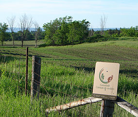 Map of Ottawa showing the Greenbelt surrounding the urban core
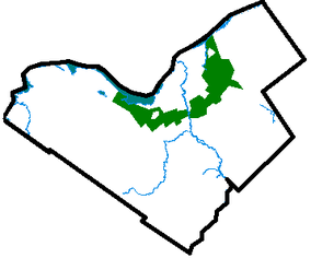
Location Southern Ontario, Canada Nearest city Ottawa Area 203.5 square kilometres (78.6 sq mi) Established 1956 Governing body National Capital Commission Official website The Greenbelt is a 203.5 square kilometres (78.6 sq mi)[1] crescent of land within the present-day boundaries of the city of Ottawa, Ontario, Canada, in which real estate development is strictly controlled. It begins at Shirleys Bay in the west and extends to Green's Creek in the east. 149.5 square kilometres (57.7 sq mi) of the greenbelt is owned and managed by the National Capital Commission (NCC) and the rest is held by other federal government departments and private interests.[1]
Contents
History
The greenbelt was proposed by Jacques Gréber in 1950 as part of his master plan for Ottawa, and the federal government started expropriating land in 1956. Its original purpose included the prevention of urban sprawl (which was threatening the rural areas surrounding the city), as well as to provide open space for the future development of farms, natural areas and government campuses.[2] At the time, the greenbelt was "intended to circumscribe an area large enough for the accommodation of some 500,000 persons. The inner limit was chosen by considering what area could be economically provided with municipal services."[3]
The present City of Ottawa comprises an extensive urban area surrounded by an even more extensive rural zone, a situation brought about by the January 1, 2001 amalgamation of Ottawa with several surrounding municipalities, both urban and rural. As a result, the Greenbelt no longer surrounds Ottawa, but rather it forms an arc through the inside of the city.
Today, land cover within the current Greenbelt comprises mainly forest, wetland, and fields - all with mixed use for recreation, conservation, farming, research, forestry. It also includes limited urban development, including government buildings and the Ottawa/Macdonald-Cartier International Airport. To date, the Ottawa Greenbelt is among the largest urban parks in the world.
The Greenbelt's success in curbing urban sprawl is difficult to measure because it is not known what the city would have looked like without it. As Ottawa had a population of 859,704 in 2005, it has clearly grown beyond what Gréber planned that the greenbelt should hold. Greenbelt detractors commonly reference the former city of Kanata, which lies just to the west of the greenbelt, as proof that development leapfrogged the greenbelt.
Proponents, however, point out that Kanata was planned as a separate and independent city cotemporaneously with the greenbelt (in fact, it was to have a greenbelt of its own). Other areas of major development beyond the greenbelt (such as Stittsville in the west and Orléans in the east) are historical towns in their own right which grew outside the planning area of Ottawa.
Half a century later, it is hard to know whether the greenbelt delayed the popularity of these towns as bedroom communities. More recently, Barrhaven in the southwest and new developments in the southeast (along Riverside Drive and Bank Street) are developing quickly beyond the greenbelt. Regardless of its role in preventing urban sprawl, the presence of the Greenbelt has ensured that there are large protected rural and green areas in proximity to Ottawa's urban and suburban developed areas.
Development
The City of Ottawa is undergoing an Official Plan Review which, among other things, examines the need for additional land for urban purposes. It considers whether a discussion of urban land should include the option of some development within the Greenbelt and it is intended that this discussion will feed into the NCC’s review of the Greenbelt Master Plan. All views expressed in [the] White Paper are those of the City of Ottawa and not those of the National Capital Commission [4] which owns and operates the Greenbelt. The City of Ottawa has identified more than 13,700 acres (55 km2) of the Greenbelt, worth about $1.6 billion, that could be developed, and in their view, without damaging its overall integrity.[5] Environment Minister Jim Prentice, opposes development in what he considers an important part of the city's heritage. Mr. Prentice vowed to fight any such move.[5]
Wildlife

The Greenbelt is home to a large variety of wildlife:
- Mammals: bat, bear, beaver, coyote, cottontail rabbit, fisher, muskrat, porcupine, raccoon, red fox, red squirrel, snowshoe hare, skunk, white-tailed deer
- Birds: Barred owl, Great Grey Owl, Great Blue Heron, Hawk, Falcon
- Insects: walking stick, praying mantis, butterflies
- Reptiles/Amphibians: common garter snake, painted turtle, snapping turtle
Places of interest
 Trail marker
Places of interest within the Greenbelt are from east to west:
- Greens Creek Conservation Area – a nature reserve of a small tributary of the Ottawa River, cutting through a lush clay valley. 45°28′00″N 75°34′35″W / 45.4666667°N 75.57639°W
- Hornets Nest soccer fields – 11 soccer fields and an air-supported dome for indoor soccer. 45°26′35″N 75°34′35″W / 45.44306°N 75.57639°W
- Pine View Golf Course – 36-hole public course 45°25′50″N 75°35′50″W / 45.43056°N 75.59722°W
- Mer Bleue Conservation Area – 33 km² sphagnum peat bog. There are some 20 km of walking trails, including a 1.2 km boardwalk, through a remarkable boreal-like ecosystem normally not found this far south. Stunted black spruce, tamarack, together with bog rosemary, blueberry, and cottongrass, are some of the unusual species that have adapted to the acidic waters of the bog. The Mer Bleue bog (French for Blue Sea) got its name from the autumn morning fogs that make it appear as a blue sea. 45°24′00″N 75°30′00″W / 45.4°N 75.5°W
- Pine Grove Forest – 12 km² of mixed-use forest for hiking, wildlife reserve, and forestry. 45°21′30″N 75°36′00″W / 45.35833°N 75.6°W
- Conroy Pit – a 1.1 km² site on a former sand/gravel pit off Conroy Road near Hunt Club Road, now used primarily as an off-leash dog park and for tobogganing in the winter. It has several kilometres of urban forest trails and wide open areas. The north end of the pit features a large toboggan hill. 45°21′30″N 75°37′30″W / 45.35833°N 75.625°W
- Macdonald-Cartier International Airport – Ottawa's main airport for domestic, international, and general aviation. 45°19′30″N 75°40′00″W / 45.325°N 75.6666667°W
- Agriculture Canada Research Farms – 17 km² site for research in animal disease prevention and treatment. 45°19′08″N 75°45′12″W / 45.31889°N 75.75333°W
- The Log Farm – a restored homestead from 1857, with guided tours. 45°17′59″N 75°47′50″W / 45.29972°N 75.79722°W
- Bruce Pit – a second former sand/gravel pit off Cedarview Road between Hunt Club Road and Baseline Road. It is now used as an off-leash dog park, and has a cross-country trail system and a toboggan hill. 45°19′30″N 75°48′00″W / 45.325°N 75.8°W
- Lime Kiln (Trail) – Trail to remains of 19th-century Flood industrial lime kiln.45°17′13.7″N 75°48′48.8″W / 45.287139°N 75.813556°W
- Stony Swamp Conservation Area – 20 km² of provincially significant wetland. It is also the largest forested area within the Greenbelt[6] and is popular for hiking and outdoor recreation. It is also the study area for the Macoun Field Club.45°18′00″N 75°50′20″W / 45.3°N 75.83889°W
- National Capital Equestrian Park 45°20′22″N 75°51′10″W / 45.33944°N 75.85278°W
- Ottawa Municipal Campground – public campground with 300 serviced sites.45°19′50″N 75°52′00″W / 45.33056°N 75.8666667°W
- The 19th Tee Driving Range – golf driving range and 18 hole mini-putt park. 45°20′43″N 75°52′38″W / 45.34528°N 75.87722°W
- Connaught Army Cadet National Summer Training Centre – Military and cadet training centre, also used by private shooting associations. 45°21′40″N 75°54′00″W / 45.36111°N 75.9°W
- Shirleys Bay – an important wetland on the Ottawa River, home to migratory birds and water fowl. This location is ideally suited for bird watching. 45°23′00″N 75°55′00″W / 45.3833333°N 75.9166667°W
References
- ^ a b "Greenbelt History and Culture". National Capital Commission. http://www.canadascapital.gc.ca/bins/ncc_web_content_page.asp?cid=16297-16299-9735-9742&lang=1. Retrieved 2008-03-25.
- ^ "Greenbelt Location Details". National Capital Commission. http://www.canadascapital.gc.ca/bins/ncc_web_content_page.asp?cid=16297-24521-29607-29527&lang=1&site=22&bhcp=1. Retrieved 2008-03-25.
- ^ Eggleston, W., 1961. The Queen's Choice. The National Capital Commission, Ottawa, Ontario, 325 pp.
- ^ City of Ottawa Greenbelt Whitepaper
- ^ a b OTTAWA HOUSING MARKET: Ottawa Greenbelt Development Under Review
- ^ "Stony Swamp". The National Capital Greenbelt. National Capital Commission. http://www.canadascapital.gc.ca/bins/ncc_web_content_page.asp?cid=16297-16299-9735-9744&bhcp=1&lang=1. Retrieved 11 July 2011.
External links
Protected areas in Ontario National parks 
Provincial parks Conservation areas Boyd · Claireville · Cold Creek · Guelph Lake · Heber Down · Kortright Centre · Lake Laurentian · Mer Bleue · Mount Nemo · Rattlesnake Point · Spencer Gorge / Webster's Falls · more...UNESCO Biosphere Reserves Georgian Bay Littoral · Long Point · Niagara Escarpment (including Cheltenham Badlands) · Thousand Islands - Frontenac Arch · Wasaga BeachNational Historic Sites of Canada Central Experimental Farm · Dundurn Castle · Laurier House · Massey Hall · Montgomery's Tavern · Osgoode Hall · Parliament · Rideau Canal · Rideau Hall · more...Other areas Categories:- Geography of Ottawa
- Landforms of Ontario


Wikimedia Foundation. 2010.