- Jefferson National Expansion Memorial
-
Jefferson National Expansion Memorial IUCN Category V (Protected Landscape/Seascape)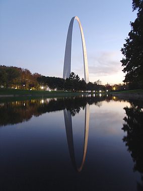
Location St. Louis, Missouri, USA Coordinates 38°37′29″N 90°11′06″W / 38.6246°N 90.18497°WCoordinates: 38°37′29″N 90°11′06″W / 38.6246°N 90.18497°W Area 192.83 acres (78.04 ha)
90.96 acres (36.81 ha) federalEstablished December 21, 1935 Visitors 2,944,976 (in 2005) Governing body National Park Service The Jefferson National Expansion Memorial is in St. Louis, Missouri, near the starting point of the Lewis and Clark Expedition. It was designated as a National Memorial by Executive Order 7523, on December 21, 1935, and is maintained by the National Park Service (NPS).
The park was established to commemorate:
- the Louisiana Purchase, and the subsequent westward movement of American explorers and pioneers;
- the first civil government west of the Mississippi River;
- the debate over slavery raised by the Dred Scott case.
The memorial consists of a 91-acre (36.8 ha) park along the Mississippi River on the site of the earliest buildings of St. Louis; the Old Courthouse, a former state and federal courthouse that saw the origins of the Dred Scott case; the 45,000 sq ft (4,200 m2) Museum of Westward Expansion; and most notably, the Gateway Arch, an inverted steel catenary arch that has become the definitive icon of the city.
Contents
Components
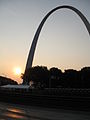
The Gateway Arch
Main article: Gateway Arch The Gateway Arch
The Gateway Arch is known as the "Gateway to the West". It was designed by Finnish-American architect Eero Saarinen and structural engineer Hannskarl Bandel in 1947 and built between 1963 and October 1965. It stands 630 feet (192 m) tall and 630 feet (192 m) wide at its base. The legs are 54 feet (16.5 m) wide at the base, narrowing to 17 feet (5.2 m) at the arch. There is a unique tram system to carry passengers to the observation room at the top of the arch.
Old Courthouse
Main article: Old Courthouse (St. Louis, Missouri)The Old Courthouse is built on land originally deeded by St. Louis founder Auguste Chouteau. It marks the location over which the arch reaches. Its dome was built during the American Civil War and is similar to the dome on the United States Capitol which was also built during the Civil War. It was the site of the local trials in the Dred Scott case.
The courthouse is the only portion of the memorial west of I-70. To the west of the Old Courthouse is a Greenway between Market and Chestnut Streets which is only interrupted by the Civil Courts Building which features a pyramid model of the Mausoleum of Mausolus (which was one of the Seven Wonders of the Ancient World) on its roof. When Civil Courts building was built in the 1920s the Chouteau family sued to regain the property belonging to the Old Courthouse because it had been deeded in perpetuity to be a courthouse.
Museum of Westward Expansion
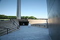
Underneath the Arch is a visitor center, entered from a descending outdoor ramp starting at either base. Within the center is the Museum of Westward Expansion, exhibits on the history of the St. Louis riverfront, and tram loading and unloading areas. Tucker Theater, finished in 1968 and renovated 30 years later, has about 285 seats and shows a documentary (Monument to the Dream) on the Arch's construction. Odyssey Theater, designed by Cox/Croslin Architects, Robert Cox, AIA and Charles Croslin, AIA, was completed in 1993 and has 255 seats. It was the first 70 mm film theater to be located on National Park Service grounds and operated by the NPS. The theater runs films from a rotating play list. Also located in the visitor center are retail operations run by the Jefferson National Parks Association, a not-for-profit partner.
History
 View of the Old Courthouse from the observation area at the top of the arch.
1930s
The memorial was developed largely through the efforts of St. Louis civic booster Luther Ely Smith who first pitched the idea in 1933, was the long-term chairman of the committee that selected the area and persuaded Franklin Roosevelt in 1935 to make it a national park after St. Louis passed a bond issue to begin building it, and who partially financed the 1947 architectural contest that selected the Arch.[1]
In the early 1930s the United States began looking for a suitable memorial for Thomas Jefferson (the Washington Monument and the newly built Lincoln Memorial were the only large Presidential memorials at the time).
Shortly after Thanksgiving in 1933 Smith who had been on the commission to build the George Rogers Clark National Historical Park in Indiana, was returning via train when he noticed the poor condition or the original platted location of St. Louis along the Mississippi. He thought that the memorial to Jefferson should be on the actual location that was symbolic of one of Jefferson's greatest triumphs—the Louisiana Purchase.
The originally platted area of St. Louis included:
- Site of the Spanish capital of Louisiana (New Spain) (basically the entire Louisiana Purchase area north of Louisiana from the city's founding in 1764 until it was turned .
- Site of the Battle of Saint Louis, the only battle west of the Mississippi River in the American Revolutionary War
- Site of the Three Flags Day ceremony in 1804 in which Spain turned over Louisiana to France for less than 24 hour before it was turned over to the United States clearing the way for Lewis and Clark to legally begin their exploration (which Spain had specifically prohibited)
- Site of the first capital of Upper Louisiana for the United States
Almost all of the historic buildings associated with this period had been replaced by newer buildings. His idea was to raze all of the buildings in the original St. Louis platted area and replace it with a park with "a central feature, a shaft, a building, an arch, or something which would symbolize American culture and civilization."
 The Missouri state quarter, showing the Arch and the Lewis and Clark expedition
Smith pitched the idea to Bernard Dickmann who quickly assembled a meeting of St. Louis civic leaders on December 15, 1933 at the Jefferson Hotel and they endorsed the plan and Smith became chairman of what would become the Jefferson National Expansion Memorial Association (a position he would hold until 1949 with a one-year exception).
The Commission then defined the area, got cost estimates of $30 million to buy the land, clear the buildings and erect a park and monument. With promises from the federal government (via the United States Territorial Expansion Memorial Commission) to join if the City of St. Louis could raise money.
The area to be included in the park was the Eads Bridge/Washington Avenue on the north and Poplar Street on the south, the Mississippi River on the east and Third Street (now I-70) on the west. The Old Courthouse, just west of Third Street, was added in 1940.[citation needed]
The only building in this area not included was the Old Cathedral, which is on the site of St. Louis first church and was opposite the home of St. Louis founder Auguste Chouteau. The founders of the city were buried in its graveyard (but were moved in 1849 to Bellefontaine Cemetery during a cholera outbreak).
Taking away 40 blocks in the center of St. Louis was bitterly fought by some sources—particularly the St. Louis Post-Dispatch.[2] On September 10, 1935, the voters of St. Louis approved a $7.5 million bond issue to buy the property.
The buildings were bought for $7 million by the federal government via Eminent domain and was subject to considerable litigation but were ultimately bought at 131.99 percent of assessed valuation.[3] Roosevelt inspected the memorial area on October 14, 1936 during the dedication of the St. Louis Soldiers Memorial. Included in the party was then Senator Harry S. Truman.[4]
1940s
The land was to be cleared by 1942. Among the buildings razed was the "Old Rock House" 1818 home of fur trader Manuel Lisa (now occupied by the stairs on the north side of the Arch) and the 1819 home of original St. Louis pioneer Jean Pierre Chouteau at First and Washington.[5]
The architectural competition for a monument was delayed by World War II. Interest in the monument was fed after the war as it was to be the first big monument in the post-World War II era.
The estimated cost of the competition was $225,000 and Smith personally donated $40,000. Civic leaders held the nation-wide competition in 1947 to select a design for the main portion of the Memorial space.
Architect Eero Saarinen won this competition with plans for a 590 ft (179.83 m) catenary arch to be placed on the banks of the Mississippi River. However, these plans were modified over the next 15 years, placing the arch on higher ground and adding 40 m (131.2 ft) in height and width.
The central architectural feature at the base of the arch is the Old Courthouse, which was once the tallest building in Missouri and has a dome similar to the United States Capitol and was placed on the building during the American Civil War at the same time as that on the U.S. Capitol.
Saarinen developed the shape with the help of architectural engineer Hannskarl Bandel. It is not a pure inverted catenary. Saarinen preferred a shape that was slightly elongated and thinner towards the top, a shape that produces a subtle soaring effect, and transfers more of the structure's weight downward rather than outward at the base.
When Saarinen won the competition, the official notification was sent to "E. Saarinen", thinking it to be the architect's father Eliel Saarinen, who had also submitted an entry. The family celebrated with a bottle of champagne, and two hours later an embarrassed official called to say the winner was, in fact, the younger Saarinen. The elder Saarinen then broke out a second bottle of champagne to celebrate his son's success.
Among the five finalists was local St. Louis architect Harris Armstrong.
1950s
Land for the memorial was formally dedicated on June 10, 1950 by Harry S Truman. However the Korean War began and the project was put on hold.
On June 23, 1959, work begins on covering railroad tracks that cut across the memorial grounds.
1960s
On February 11, 1961 excavation began.
On September 1, 1961 Saarinen died.
On February 12, 1963 the first stainless steel triangle that forms the first section of the arch was set in place on the south leg.
On October 28, 1965 it was completed, costing approximately US$15 million to build. The adjacent park was designed by landscape artise Dan Kiley. Along with all other historical areas of the National Park Service, the memorial was listed on the National Register of Historic Places on October 15, 1966. Vice President Hubert Humphrey and Secretary of the Interior Stewart Udall dedicated the Arch on May 25, 1968.
1980s
In 1984, Congress authorized the enlargement of the Memorial to include up to 100 acres (40.5 ha) on the east bank of the Mississippi River in East St. Louis, Illinois. Funds were authorized to begin land acquisition, but Congress placed a moratorium upon NPS land acquisitions in fiscal year 1998. The moratorium continued into the 21st century, with expansion becoming less likely because of the construction of a riverboat gambling facility and related amenities.
1990s
During the Great Flood of 1993, Mississippi flood waters reached halfway up the Grand Staircase on the east.
In 1999, the Arch tram queue areas were renovated at a cost of about $2.2 million. As well, the Ulysses S. Grant National Historic Site in St. Louis County, Missouri was put under the jurisdiction of the Superintendent of the Memorial.
2000s
The arch was featured on the Missouri state quarter in 2003.
In 2007 St. Louis Mayor Francis Slay and former Missouri Senator John Danforth asked the National Park Service to create a more "active" use of the grounds of the memorial and model it on Millennium Park in Chicago including the possibility of an amphitheater, cafes and restaurants, fountains, bicycle rentals, sculptures and an aquarium.[6] The National Park Service was not in favor of the plan noting that the only other overt development pressure on National Park property has been at the Jackson Hole Airport in Grand Teton National Park[7]
2010s
The Memorial is separated from the rest of Downtown St. Louis by a sunken section of I-70. The city is considering a $90 million proposal to cover the interstate. The NPS, as part of their Centennial Initiative celebrating its 100th anniversary in 2016, is considering a plan to complete Saarinen's original master plan. The intention is to build the Gateway Arch Connector to link the Old Courthouse with the grounds of the Arch.[8] In September 2010 Michael Van Valkenburgh Associates won a design contest to "re-envision the visitor experience" of the grounds.[9] The projected completion of the project is planned for 2015 to coincide with the 50th anniversary of the completion of the Arch. The plan includes:[10]
- replacing the north garage with an amphitheater,
- new cobblestone plaza between the Arch and the river,
- elevated walkways on the Illinois side, reaching 35 feet and winding through a new bird sanctuary, (Congress has authorized purchase of the Illinois acreage)
- and covering I-70 and creating a new western entrance through an expanded museum below the Gateway Arch.
In 2010 officials said they are looking to replace 1,000 ash trees on the grounds that may be destroyed by emerald ash borers.[11]
Additional photographs
-
Lower north tram queue area
-

The Arch from the west, looking east over Luther Ely Smith Square
-

The sign at the top of the observation deck.
-

The St. Louis Arch as seen from the lawn.
-

As seen from Laclede's Landing
-
Arch at dawn
-

The Old Cathedral as viewed from top of Arch
-
South entrance to the arch
-

At night as seen from Illinois
-

Gateway Arch from below
-

Looking west from the observatory
-
-
References
- ^ Luther Ely Smith: Founder of a Memorial - The Museum Gazette - nps.gov - Retrieved January 11, 2008
- ^ Editorial - Jefferson City Daily Capital News - June 24, 1939
- ^ St. Louis Site Obtained For Jefferson Memorial - UP Article via Hammond Times - June 22, 1939 (available on newspaperarchive.com)
- ^ 225,00 See Roosevelt in St. Louis - AP Article via Moberly Monitor-Index - October 14, 1936
- ^ St. Louis Landmarks - geneaologyinstlouis.accessgenealogy.com - Retrieved January 11, 2008
- ^ Danforth Study Says Hopes for Future of Riverfront Lie in Arch Grounds Mayor Slay Seeks Recommendations on Next Step - Mayor's Office Press Releases - August 29, 2007
- ^ City leaders pitch local control of Arch grounds - St. Louis Post Dispatch - August 29, 2007
- ^ Bomar, Mary A. (August 2007). "Summary of Park Centennial Strategies" (PDF). National Park Service. http://www.nps.gov/2016/assets/files/Summary-of-Park-Centennial-Strategies.pdf. Retrieved 2008-02-15.
- ^ http://www.cityarchrivercompetition.org
- ^ http://www.stltoday.com/news/local/metro/article_ccccaf5a-c5ba-11df-ae53-00127992bc8b.html
- ^ http://www.kansascity.com/2010/10/11/2301527/officials-to-discuss-replacing.html
- Nation Register of Historic Places - Nomination Forms
- "Gateway Arch" (PDF). Missouri Department of Natural Resources. http://dnr.mo.gov/shpo/nps-nr/87001423.pdf. Retrieved 2008-05-30.
- "Jefferson National Expansion Memorial" (PDF). Missouri Department of Natural Resources. http://dnr.mo.gov/shpo/nps-nr/66000941.pdf. Retrieved 2008-05-30.
External links
- Official NPS website: Jefferson National Expansion Memorial
- The Old Courthouse in St. Louis: Yesterday and Today, a National Park Service Teaching with Historic Places (TwHP) lesson plan
- The memorial's 2000-2005 Strategic Plan (in Microsoft Word format)
- Website for “The Gateway Arch: A Reflection of America”, a documentary narrated by Kevin Kline and directed by award winning documentarians Scott Huegerich and Bob Miano of Civil Pictures.
- Gateway Arch tourism site, run by the Bi-State Development Agency
- Jefferson National Parks Association, a park partner which administers the Museum Store and the Levee Mercantile Store
- Gateway Arch Construction Photographs from the Western Historical Manuscript Collection at the University of Missouri–St. Louis
- St. Louis math teacher William V. Thayer's web pages on arch mathematics [1][2]
- Web page for the equations of the Arch on the official website of the Jefferson National Expansion Memorial [3]
- 1980 Darwin Award
- The National Parks: Index 2001–2003. Washington: U.S. Department of the Interior.
- Arch timeline from the St. Louis Post-Dispatch
U.S. National Register of Historic Places Topics Lists by states Alabama • Alaska • Arizona • Arkansas • California • Colorado • Connecticut • Delaware • Florida • Georgia • Hawaii • Idaho • Illinois • Indiana • Iowa • Kansas • Kentucky • Louisiana • Maine • Maryland • Massachusetts • Michigan • Minnesota • Mississippi • Missouri • Montana • Nebraska • Nevada • New Hampshire • New Jersey • New Mexico • New York • North Carolina • North Dakota • Ohio • Oklahoma • Oregon • Pennsylvania • Rhode Island • South Carolina • South Dakota • Tennessee • Texas • Utah • Vermont • Virginia • Washington • West Virginia • Wisconsin • WyomingLists by territories Lists by associated states Other  Category:National Register of Historic Places •
  Portal:National Register of Historic Places
Museums in Greater St. Louis National Museum of Westward ExpansionState Municipal Private City Museum · Contemporary Art Museum St. Louis · Historic Aircraft Restoration Museum · Laumeier Sculpture Park · Mildred Lane Kemper Art Museum · Missouri History Museum · Museum of Transportation · The Pulitzer Foundation for the Arts · St. Louis Cardinals Hall of Fame Museum · St. Louis Science Center · St. Louis University Museum of ArtProtected Areas of Missouri Federal Jefferson National Expansion MemorialNational Wildlife Refuges:Big Muddy • Clarence Cannon • Great River • Middle Mississippi River • Mingo • Ozark Cavefish • Pilot Knob • Squaw Creek • Swan Lake • Two RiversNational Forests:State Babler • Sam A. Baker • Bennett Spring • Big Lake • Big Oak Tree • Big Sugar Creek • Castlewood • Crowder • Cuivre River • Current River • Elephant Rocks • Finger Lakes • Graham Cave • Grand Gulf • Ha Ha Tonka • Harry S Truman • Hawn • Johnson's Shut-Ins • Jones-Confluence Point • Katy Trail • Knob Noster • Lake of the Ozarks • Lake Wappapello • Lewis and Clark • Long Branch • Mark Twain • Meramec • Montauk • Morris • Onondaga Cave • Pershing • Pomme de Terre • Prairie • Roaring River • Robertville • Rock Bridge Memorial • Route 66 • St. Francois • St. Joe • Stockton • Table Rock • Taum Sauk Mountain • Thousand Hills • Trail of Tears • Van Meter • Wakonda • Wallace • Washington • Watkins Woolen Mill • Weston BendArrow Rock • Battle of Athens • Battle of Carthage • Battle of Lexington • Thomas Hart Benton Home and Studio • Bollinger Mill • Nathan Boone Homestead • Boone's Lick • Bothwell Lodge • Clark's Hill/Norton • Confederate Memorial • Deutschheim • Dillard Mill • Gov. Daniel Dunklin's Grave • Felix Vallé House • First Missouri State Capitol • Fort Davidson • Gen. John J. Pershing Boyhood Home • Harry S Truman Birthplace • Hunter-Dawson • Iliniwek Village • Jefferson Landing • Jewell Cemetery • Locust Creek Covered Bridge • Mark Twain Birthplace • Mastodon • Missouri Mines • Missouri State Capitol • Missouri State Museum • Osage Village • Sandy Creek Covered Bridge • Sappington Cemetery • Scott Joplin House • Towosahgy • Union Covered Bridge • Watkins Woolen MillConservation areas:List of Missouri conservation areasMissouri Department of Natural Resources Parks in Greater St. Louis St. Louis
City parksMaintained
by cityAboussie Park • Alaska Park • Aloe Plaza • Aloe Plaza West • Amberg Park • Amherst Park • Jet Banks Park • Barrett Brothers Park • Beckett Playground • Bellerive Park • Benton Park • Louis G. "Midge" Berra Park • Colonel George H. Blasé Park • Eugene "Tink" Bradley Park • Buder Playground • Busche Park • Carnegie Park • Carondelet Park • Carondelet Lions Park • Carr Square • Chain of Rocks Park • Jordan W. Chambers Park • Cherokee Park • Christy Park • Citygarden • Clifton Heights Park • Compton Hill Reservoir Park • Costello Park • De Soto Park • Dickman Park • Dwight Davis Park • Eads Square Park • Ellendale and Arsenal Park • Fairground Park • Fanetti Plaza • Forest Park • Fountain Park • Fourteeth Street Mall • Fox Park • Father Filipiac Park • Francis Park • Franz Park • Fremont Park • Gamble Park • Garrison-Brantner-Webster Park • Gateway Mall • Gwen B. Giles Park • Grand Center Park • Gravois Park • W.C. Handy Park • David Hickey Park • Hyde Park • Interco Plaza • Jackson Place Park • Kaufmann Park • Kenrick Garden Triangle Park • Kiener Plaza • Kingsbury Square Park • Laclede Park • Lafayette Park • Ray Leisure Park • Lindenwood Park • Lucas Garden Park • Phillip Lucier Park • Lyon Park • Marquette Park • May Amphitheater • McDonald Park • Memorial Plaza • Mestres Park • Minnesota & Hill Park • Minniewood Park • Mount Pleasant Park • O'Fallon Park • Parkland Park • Penrose Park • Ivory Perry Park • Poelker Park • Pontiac Square Park • Ruth Porter Park • River Des Peres Park • River Des Peres Extension • Rumbold Park • Ernest J. Russell Park • Serra Sculpture Park • Sherman Park • Sister Marie Charles Park • Soulard Playground • South St. Louis Square Park • St. Louis Place Park • St. Marcus Commemorative Park • Strodtman Park • Sublette Park • Tambo Park • Tandy Park • Robert Terry Park • Tiffany Park • Rosalie Tilles Park • Milton Turner Playground • Vivian and Astra Park • Walnut Park • Washington Square Park • Willmore Park • Windsor Park • Yeatman Square ParkMaintained
by othersJefferson National Expansion Memorial Park • Leon Strauss Park • Luther Ely Smith Park • Tower Grove ParkSt. Louis
County parksNorth area Bella Fontaine County Park • General Daniel Bissell House County Park • Bon Oak County Park • Castlepoint County Park • Champ County Park • Endicott County Park • Fort Belle Fontaine County Park • King County Park • Kinloch County Park • Larimore County Park • McDonnell County Park • Sioux Passage County Park • Spanish Lake County Park • St. Vincent County Park • Veterans Memorial County ParkWest area Creve Coeur County Park • Ebsworth County Park • Faust County Park • Greensfelder County Park • Lone Elk County Park • Love County Park • Queeny County Park • Tilles County Park • West Tyson County ParkSouth area Bee Tree County Park • Black Forest County Park • Bohrer County Park • Buder County Park • Cliff Cave County Park • Clydesdale County Park • Jefferson Barracks County Park • Laumeier Sculpture Park • Lemay County Park • Mathilda-Welmering County Park • Ohlendorf County Park • Simpson County Park • Suson County Park • Sylvan Springs County Park • Unger County Park • George Winter County ParkCategories:- IUCN Category V
- Buildings and structures completed in 1965
- Arches and vaults
- Buildings and monuments honoring American Presidents
- Buildings and structures in St. Louis, Missouri
- Eero Saarinen structures
- Lewis and Clark Expedition
- Buildings and structures on the National Register of Historic Places in Missouri
- National Memorials of the United States
- Parks in St. Louis, Missouri
- Protected areas on the Mississippi River
- Thomas Jefferson
- Modernist architecture in the United States
- American architecture
- History of St. Louis, Missouri
- Museums in St. Louis, Missouri
- Protected areas established in 1935
- History museums in Missouri
- United States National Park Service areas in Missouri
- Monuments and memorials in Missouri


Wikimedia Foundation. 2010.