- Sorong (city)
-
Sorong
Nuwar— City — Nickname(s): Cahaya Islam Location of the town in the Bird's Head Peninsula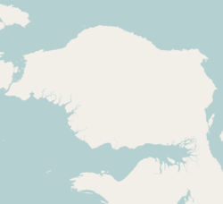
 SorongLocation of the town in Indonesia
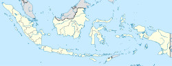 Sorong
Coordinates: 0°52′S 131°15′E / 0.867°S 131.25°E Country  Indonesia
Province West Papua Population – City 125,535 – Metro 184,239 Time zone WIB (UTC+7) Sorong is a chartered coastal city in the eastern Indonesian province of West Papua. Its only land borders are with Sorong Regency. It is the gateway to Indonesia's Raja Ampat Islands, species rich coral reef islands in an area considered the heart of the world's coral reef biodiversity. It also the logistics hub for Indonesia's thriving eastern oil and gas frontier. Sorong has experienced exponential growth in the last five years, and further growth is anticipated as Sorong becomes linked by road to other frontier towns in Papua's Bird's Head Peninsula. The city has a population of 125,535.
Container port
A container port will be built in Sorong with an annual container handling capacity of 500,000 twenty-foot equivalent units (TEUs) and cost Rp.800 billion ($93.6 million). Construction will be initilised at early 2012 and expect to finish in the middle of 2013.[1]
Sister Cities
References
Coordinates: 0°52′S 131°15′E / 0.867°S 131.25°E
West Papua Capital: ManokwariRegencies 
Cities Sorong
Categories:- Sorong (city)
- Populated places in West Papua
- Western New Guinea
- Port cities and towns in Indonesia
- Cities in Indonesia
- Populated coastal places in Indonesia
- Maluku Islands and New Guinea (Indonesia) geography stubs


Wikimedia Foundation. 2010.