- Utah State Route 202
Infobox road
state=UT
type=SR
route=202
section=126
maint=UDOT 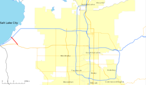
map_notes=SR-202 in red
length_mi=1.907
length_round=3
length_ref=cite web|url=http://www.dot.utah.gov/main/uconowner.gf?n=7213030026918112 |title=Route 202|date=May 2008|work= [http://www.udot.utah.gov/main/f?p=100:pg:3977778294530221:::1:T,V:814 Highway Reference] |publisher=Utah Department of Transportation |accessdate=2008-09-15|format=PDF]
established=1969
direction_a=South
terminus_a=jct|state=UT|UT|201 near Magna
direction_b=North
terminus_b=jct|state=UT|I|80 near Magna
previous_type=SR
previous_route=201
next_type=SR
next_route=203State Route 202 (SR-202) is a convert|1.907|mi|km|3|sing=on long
state highway in theU.S. state ofUtah that serves as a connector, linking SR-201 to Interstate 80 (I-80) in rural Salt Lake County. The road has existed since at least 1937, when it connected U.S. Route 40 (US-40) and US-50 via the Garfield Cut-Off Road.Route description
Located entirely in Salt Lake County, SR-202 begins at an intersection with SR-201 and 11500 West northwest of Magna. The road travels north-northwesterly, bordered on the east by a large
tailing pond owned byKennecott Utah Copper and part of the formerDenver and Rio Grande Western Railroad rail line,cite map|url=http://www.udot.utah.gov/main/uconowner.gf?n=95924727685859511|title="General highway map - Salt Lake County, Utah"|publisher=Utah Department of Transportation|accessdate=2008-09-15|year=2005] which is now owned by theUnion Pacific Railroad (UP). The parallel rail line intersects a pair of east–west rail lines, the southern line being UP main line, and the northern line being theFeather River Route of the formerWestern Pacific Railroad , which is now owned by UP.cite map|title = Utah Multipurpose Map|publisher = Utah Travel Council|cartography = AAA Engineering and Drafting|page 103-105|series = 5 of 7|section = F-1|scale = 1:250,000] After crossing the rail lines, SR-202 intersects with I-80 near theGreat Salt Lake State Park and comes to a terminus at the I-80 frontage road, which provides access to the Great Salt Lake State Park and to the SaltAir.cite map|title=SR-202 Overview|cartography=Tele Atlas |publisher=Google Maps |accessdate=2008-10-07|url=http://maps.google.com/maps?f=d&saddr=Great+Salt+Lake+State+Park&daddr=40.726007,-112.162739&hl=en&geocode=FRbAbQIdnC5Q-Q%3B&mra=dme&mrcr=0&mrsp=1&sz=17&sll=40.725852,-112.162482&sspn=0.003334,0.007929&ie=UTF8&ll=40.736852,-112.167234&spn=0.026664,0.063429&z=14] Kennecott Utah Copper owns all of the land surrounding SR-202, except for the right-of-way for the railroad, and the highway itself.cite map |publisher=Salt Lake County Assessors Office |title=Assessor Parcel Viewer / Public Version |url=http://maps.slco.org/website/assessor/public_parcelviewer/viewer.htm |cartography=ArdMS |accessdate=2008-09-27|year=2008]SR-202 serves as a vital link for travelers on SR-201 who want to travel eastbound on I-80 because SR-201 traffic only has the option to continue on I-80 westbound, and does not have an offramp to eastbound I-80.cite map|title=SR-201/I-80 interchange |cartography=NAVTEQ|publisher=Google Maps|accessdate=2008-09-15 |url=http://maps.google.com/maps?f=q&hl=en&geocode=&q=magna,+ut&ie=UTF8&ll=40.722868,-112.224398&spn=0.006668,0.015857&z=16] Traffic on SR-202 has increased 12 percent between 2002 and 2007, with a daily average of 735 cars per day using SR-202 in 2007,cite web|url=http://www.udot.utah.gov/main/uconowner.gf?n=2363711025498494585|title=Traffic on Utah Highways 2007|publisher=Utah Department of Transportation|accessdate=2008-09-15|format=PDF|date=2008-07-02] compared to 475 cars per day in 2002.cite web|url=http://www.udot.utah.gov/main/uconowner.gf?n=200507121112121|title=Traffic on Utah Highways 2004|publisher=Utah Department of Transportation|accessdate=2008-09-15|format=PDF|date=2005-12-13] Half of the traffic on SR-202 consists of buses and trucks.cite web|url=http://www.udot.utah.gov/main/uconowner.gf?n=2363733707060508179|title=Truck Traffic on Utah Highways 2007|date=2008-08-18|publisher=Utah Department of Transportation|accessdate=2008-09-15|format=PDF]
History
Two other roads have been designated Utah State Route 202 in the past. From 1939 to 1953, the name was used by the road that formed the eastern approach to
Mercur, Utah and later became part of SR-73. [cite UTSR law|year=1939|quote=Route 202. From a point on route 73 near Fairfield westerly to Mercur.] From 1961 to 1967, the name was used by Main Street between SR-201 (2100 South) and SR-171 in downtown Salt Lake City, which is now part of SR-186.cite web|url=http://www.udot.utah.gov/main/uconowner.gf?n=200609190948311|title=Route 176|date=November 2007|work= [http://www.udot.utah.gov/main/f?p=100:pg:3977778294530221:::1:T,V:1348 Highway Resolutions] |publisher=Utah Department of Transportation|accessdate=2008-10-07|format=pdf]The road that currently carries the SR-202 designation has existed since 1937, when it connected US-40 and US-50 along the Garfield Cut-Off Road.cite map |publisher=
Texaco |title=Texaco Road Map Idaho, Montana, Wyoming |url=http://www.davidrumsey.com/luna/servlet/detail/RUMSEY~8~1~23818~920003:Texaco-road-map-Idaho,-Montana,-Wyo |edition= |year=1937 |cartography=Rand McNally |scale=1:1,774,080 |section=N-6 |accessdate=2008-09-15] TheUtah State Legislature designated the road SR-202 in 1969, thus taking responsibility of maintaining the road from the county.cite web|url=http://www.udot.utah.gov/main/uconowner.gf?n=200609191553311|title=Route 202|date=November 2007|work= [http://www.udot.utah.gov/main/f?p=100:pg:3977778294530221:::1:T,V:1348 Highway Resolutions] |publisher=Utah Department of Transportation|accessdate=2008-09-15|format=PDF] No changes or alterations have been made to SR-202, except for the legal definition of the road, which has changed twice since it was formed.On 26 September 2008, a
sulphuric acid spill was reported by passers-by traveling on I-80.cite news|url=http://www.ksl.com/?nid=148&sid=4368565|title=Acid spill shuts down I-80 on-ramp|last=Hollenhorst|first=John|coauthors=Giauque, Marc|date=2008-09-26|publisher=KSL-TV |accessdate=2008-10-07] The ramp from SR-202 to eastbound I-80 will be closed until repairs can be made. Currently, theSalt Lake Valley Health Department has no leads on who or what caused the acid spill.cite news|url=http://www.ksl.com/index.php?nid=148&sid=4404626|title=Cleanup continues at I-80 onramp|last=Hollenhorst |first=John|coauthors=Richards, Mary|date=2008-09-30|publisher=KSL-TV |accessdate=2008-10-01]Major intersections
References
External links
* [http://members.aol.com/utahhwys/201-220.htm#rte202 Utah Highways page]

Wikimedia Foundation. 2010.