- Dunedoo, New South Wales
-
Dunedoo
New South Wales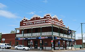
Dunedoo Hotel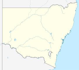
 Dunedoo
Population: 836(2006 census)[1] Established: 1840s Postcode: 2844 Coordinates: 32°01′S 149°24′E / 32.017°S 149.4°ECoordinates: 32°01′S 149°24′E / 32.017°S 149.4°E Elevation: 399 m (1,309 ft) Location: LGA: Warrumbungle Shire State District: Upper Hunter Federal Division: Parkes Mean max temp Mean min temp Annual rainfall 23.8 °C
75 °F9.5 °C
49 °F614.2 mm
24.2 inDunedoo
 /ˈdʌniduː/ dunny-doo) is a village of 836 inhabitants[1] situated within the Warrumbungle Shire of central western New South Wales, Australia. Dunedoo is well known to Australian travellers due to its distinctive name (A 'dunny' is a colloquial Australian word for a toilet). The name is actually derived from a local Aboriginal word meaning 'swan',[2] which are commonly found in the area's lagoons.
The town is located on the north-western edges of the Sydney basin.[3]
Contents
Geography and features
Dunedoo is located 399 m above sea-level on the southern bank of the Talbragar River at the intersection of the Golden and Castlereagh Highways. It is a relatively isolated township with the two nearest rural centres of Mudgee and Dubbo situated approximately to the 60 km south and 100 km west respectively. It is due to this isolation that Dunedoo has many facilities not usually found in villages of this size. Dunedoo largely functions as a service centre to the surrounding district which focuses on the production of wheat, cattle, mixed farming, timber, fat lambs and wool. As with many wheat-growing centres of western New South Wales the village's skyline is dominated by a large silo. Dunedoo also features a small hospital (Dunedoo War Memorial Hospital), two schools (a government administered combined primary and high school and a catholic primary school), a licensed hotel, a small commercial area, a small freight railway station as well as sporting and special event facilities. Dunedoo also features Catholic, Anglican and Presbyterian churches.
History
Before European settlement Dunedoo and the surrounding area was occupied by the Kamilaroi and Wiradjuri peoples. Allan Cunningham was the first British explorer to discover the area in 1823 while travelling Pandoras Pass over the Warrumbungle ranges to the Liverpool Plains. Surveyors studied the area in 1832 followed by squatters who settled the region.[4] The town was founded somewhere in the 1840s and was originally known as Bolaro and later as Redbank. Dunedoo remained a small village throughout the 19th century and the nearby town of Cobbora was considered to be the regional centre for many years. However, Dunedoo's population grew substantially after the construction of the Gwabegar railway line and the opening of passenger services in 1910.[5] Bolaro Post Office opened on 1 November 1876 and was renamed Dunedoo in 1909.[6]
The first half of the 20th century saw many of Dunedoo's residents fighting in both the first and second world wars, documented by the war memorial currently found in the town's park. The gradual loss of railway services in western NSW affected Dunedoo in the 1960s with the loss of passenger railway services, however freight trains still commonly use the line. Other services, such as the village's cinema, have also been lost over time.
In 2002, Dunedoo appeared in an ABC documentary entitled "A Loo with a View".[7] Dunedoo is currently suffering the fate of many small regional towns of NSW in that its population is gradually decreasing. Many locals fear that the town will eventually be deserted and thus many creative ideas have been floated as possible methods of reversing the current trend. The Dunedoo District Development Group had proposed to build "The Big Dunny" in the hope of attracting tourists, as the Big Banana does for Coffs Harbour and big things in other parts of Australia. The documentary centred on "The Big Dunny" proposal, it was to have been a three-storey high building featuring five-star toilets, visitor centre, viewing platform, and even a radio station. Local shire councillor and farmer Frank Gaden was against it, reckoning it would be an embarrassment. Feasibility consultant Ian Farlow concluded it would, unfortunately, attract only 30 visitors a day which would not be enough to make it worthwhile, and proposed instead an environmentally friendly self-composting toilet block. The council decided against the latter and in the end nothing was built.[8]
2005 saw the town incorporated into the newly created Warrumbungle Shire, formed from the previous Coolah and Coonabarabran Shires. The town was briefly divided over the prospect of joining Coonabarabran Shire with many preferring the town be incorporated into the Mudgee-based Mid-Western Regional Council.[9]
Climate
Dunedoo has the drier end of the Humid subtropical climate (Cfa).
Climate data for Dunedoo Month Jan Feb Mar Apr May Jun Jul Aug Sep Oct Nov Dec Year Record high °C (°F) 43.4
(110.1)43.1
(109.6)39.2
(102.6)34.1
(93.4)28.6
(83.5)24.5
(76.1)24.0
(75.2)28.5
(83.3)34.2
(93.6)36.7
(98.1)43.0
(109.4)41.7
(107.1)43.4
(110.1)Average high °C (°F) 31.9
(89.4)30.8
(87.4)28.3
(82.9)24.2
(75.6)19.5
(67.1)16.0
(60.8)15.3
(59.5)17.1
(62.8)20.6
(69.1)24.2
(75.6)27.6
(81.7)30.8
(87.4)23.9 Average low °C (°F) 16.9
(62.4)17.2
(63.0)14.3
(57.7)9.7
(49.5)6.2
(43.2)3.6
(38.5)2.0
(35.6)3.0
(37.4)5.8
(42.4)9.1
(48.4)12.3
(54.1)15.0
(59.0)9.6 Record low °C (°F) 5.2
(41.4)7.0
(44.6)1.1
(34.0)−2.2
(28.0)−5.1
(22.8)−6.7
(19.9)−8.3
(17.1)−6.7
(19.9)−3.3
(26.1)−1.7
(28.9)1.0
(33.8)3.8
(38.8)−8.3
(17.1)Precipitation mm (inches) 69.6
(2.74)64.3
(2.531)52.6
(2.071)41.5
(1.634)44.4
(1.748)44.5
(1.752)46.9
(1.846)40.8
(1.606)42.5
(1.673)52.6
(2.071)54.7
(2.154)62.7
(2.469)617.2
(24.299)Avg. precipitation days 6.2 5.7 5.0 4.6 6.3 7.3 7.9 7.2 6.7 7.0 6.7 6.6 77.2 Source: [10] Sport and culture
Dunedoo features many sporting facilities including Robertson Oval (used for rugby league and netball). The Dunedoo Sports club has a 9-hole golf course and 4 grass tennis courts, as well as 2 squash courts. Touch football is also played there during the Summer months on part of the golf course close to the club building. Dunedoo also has a lawn bowls club. Competitions are held regularly in each of these sports within the town. Dunedoo also participates in regional rugby league and cricket competitions. The local rugby league team is known as the Dunedoo Swans. Their uniform features the colours green and white.
Dunedoo is host to many festivals including the Dunedoo Bush Poetry Festival held annually in April by the Dunedoo District Development Group. The Dunedoo Show is held each February featuring carnival rides and several rodeo-themed events including whip-cracking and bull riding. The town also holds annual ANZAC Day marches and Christmas parades in the main street.
Dunedoo has a community radio station, Three Rivers Radio. It broadcasts continuously on a frequency of 96.1 MHz. Programs include Sport, Good Music Cafe, Jazz, Great Musicals, Hymns, Chatter Box (Dunedoo Central School on air each week), St Michaels School alternate weeks, Good music all the time including Frank Bourke's old time orchestra each week.
References
- ^ a b Australian Bureau of Statistics (25 October 2007). "Dunedoo (L) (Urban Centre/Locality)". 2006 Census QuickStats. http://www.censusdata.abs.gov.au/ABSNavigation/prenav/LocationSearch?collection=Census&period=2006&areacode=UCL128000&producttype=QuickStats&breadcrumb=PL&action=401. Retrieved 21 July 2009.
- ^ "Dunedoo". Geographical Names Board of New South Wales. http://www.gnb.nsw.gov.au/name_search/extract?id=JPlpjzZTJP. Retrieved 21 July 2009.
- ^ http://www.dpi.nsw.gov.au/__data/assets/image/0007/96847/20758.gif
- ^ "Dunedoo Tourism". Coolah District Telecentre. http://www.coolahddg.com.au/dunedoo.htm. Retrieved 2006-04-24.
- ^ "Dunedoo Railway Station". NSWRail.net. http://www.nswrail.net/locations/show.php?state=NSW&location=dunedoo. Retrieved 2006-04-24.
- ^ Premier Postal History. "Post Office List". Premier Postal Auctions. https://www.premierpostal.com/cgi-bin/wsProd.sh/Viewpocdwrapper.p?SortBy=NSW&country=. Retrieved 2011-05-26.
- ^ A Loo with a View documentary page at the Australian Broadcasting Corporation
- ^ Big Dunny plans go down the toilet, The Age newspaper, 8 August 2002, reviewing the documentary
- ^ "Dunedoo divided over council merger". ABC News Online. http://www.abc.net.au/news/australia/nsw/neweng/200408/s1172854.htm. Retrieved 2006-04-24.
- ^ {{cite web | url = http://www.bom.gov.au/climate/averages/tables/cw_064009_All.shtml
Categories:- Towns in New South Wales


Wikimedia Foundation. 2010.