- Albany County, New York
-
For the city of Albany, New York, see Albany, New York.
Albany County County  Seal of Albany County
Name origin: James II of England, the Duke of York and Albany Country United States State New York Region Upstate New York District Capital District Towns 10Cities Albany, Cohoes, Watervliet Villages 6County seat City of Albany - elevation 200 ft (61 m) - coordinates 42°39′35″N 73°46′53″W / 42.65972°N 73.78139°W Highest point A summit near Henry Hill [A] - location Town of Berne, near border with town of Rensselaerville - elevation 2,160 ft (658 m) - coordinates 42°33′N 74°12′W / 42.55°N 74.2°W Lowest point Hudson River at sea level - location Port of Albany-Rensselaer - elevation 0 ft (0 m) - coordinates 42°37′41″N 73°45′27″W / 42.62806°N 73.7575°W Area 533 sq mi (1,380 km2) - land 523 sq mi (1,355 km2) - water 10 sq mi (26 km2) Population 304,204 (2010) Density 581.9 / sq mi (225 / km2) Incorporated 1683 County Executive Michael G. Breslin (D) County Legislature- D1: George L. Infante (D) Albany
- D2: Lucille M. McKnight (WF) Albany
- D3: Wanda F. Willingham (D) Albany
- D4: Virginia Maffia-Tobler (D) Albany
- D5: Norma J. Chapman (D) Albany
- D6: Christopher T. Higgins (D) Albany
- D7: Brian Scavo (D) Albany
- D8: Doug Bullock (D) Albany
- D9: Donald W. Rahm (D) Albany
- D10: Daniel P. McCoy (D) Albany
- D11: Gary W. Domalewicz (D) Albany
- D12: Frank J. Commisso (D) Albany
- D13: William M. Clay (D) Albany
- D14: Raymond F. Joyce (D) Albany
- D15: Philip G. Steck (D) Loudonville
- D16: Robert J. Beston (D) Watervliet
- D17: Sean E. Ward (D) Green Island
- D18: Shawn M. Morse (WF) Cohoes
- D19: Gilbert F. Ethier (D) Cohoes
- D20: Timothy D. Nichols (D) Cohoes
- D21: David B. Mayo (D) Latham
- D22: Patrick F. Timmins (D) Newtonville
- D23: Peter B. Tunny (R) Niskayuna
- D24: Carl P. Zeilman (R) Colonie
- D25: Ryan V. Horstmyer (D) Loudonville
- D26: William M. Hoblock (R) Loudonville
- D27: Patrice Lockart (R) Colonie
- D28: Christine W. Benedict (R) Colonie
- D29: Lee Carman (R) Guilderland
- D30: Bryan M. Clenahan (D) Westmere
- D31: William F. Aylward, Jr. (D) Altamont
- D32: Mary Lou B. Connolly (D) Guilderland
- D33: Herbert W. Reilly, Jr. (D) Voorheesville
- D34: Thomas J. Cotrofeld, Jr. (D) Delmar
- D35: Charles S. Dawson, Jr. (D) Glenmont
- D36: Richard W. Mendick (R) Selkirk
- D37: Peter T. Clouse (R) Coeymans
- D38: Charles E. Houghtaling, Jr. (D) Feura Bush CHAIRMAN
- D39: Alexander E. Gordon (D) Berne
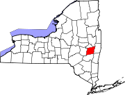
Timezone Eastern Standard Time (UTC-5) - summer (DST) Eastern Daylight Time (UTC-4) Area code 518  Map of New York highlighting Albany County
 Map of Albany County showing is cities, towns, and villages
Wikimedia Commons: Albany County, New York Website: www.albanycounty.com [A]- The highest point was Henry Hill until an open gravel pit mining operation has lowered the summit causing a nearby summit .3 miles SE to be new highest point[1] Albany County (
 /ˈɔːlbəniː/ awl-bə-nee) is a county located in the U.S. state of New York, and is part of the Albany-Schenectady-Troy Metropolitan Statistical Area. The name is from the title of the Duke of York and Albany, who became James II of England (James VII of Scotland). As of the 2010 census, the population was 304,204. As originally established, Albany County had an indefinite amount of land, but has only 530 square miles (1,400 km2) as of March 3, 1888. The county seat is Albany, the state capital.
Contents
History
Colonial
Albany County was created on November 1, 1683 by New York Governor Thomas Dongan, and later confirmed on October 1, 1691.[2] The act creating the county vaguely defined its territory "to containe the Towns of Albany, the Collony Rensselaerwyck, Schonecteda, and all the villages, neighborhoods, and Christian Plantaçons on the east side of Hudson River from Roelef's Creek, and on the west side from Sawyer's Creek (Saugerties) to the Sarraghtoga."[3] The confirmation declared in 1691 was similar but omitted the Town of Albany, substituted "Mannor of Ranselaerswyck" for "Collony Rensselaerwyck", and stated "to the uttermost end of Sarraghtoga" instead of just "to Sarraghtoga". Livingston Manor was annexed to Albany County from Dutchess County in 1717.[3] Albany's boundaries were nailed down more specificially as various state statutes would add land to the county, or more commonly subtract land for the formation of new counties.[4] In 1772 with the creation of Tryon County and Charlotte County Albany gained definitive boundaries and included what are now Albany, Columbia, Rensselaer, Saratoga, and Schenectady counties; large parts of Greene and Washington counties; and the disputed southwest corner of Vermont.[5]
The city of Albany was the first municipality within this large county,[4] as the village (dorp in Dutch) of Beverwyck by the Director-General of New Amsterdam, Pieter Stuyvesant, who also established the first court in Albany.[6] Albany was then erected as a city in 1686 by Governor Dongan through the Dongan Charter.[4] Schenectady was given a patent with some municipal rights in 1684 and became a borough in 1765.[5] The Manor of Rensselaerswyck was created as a district within the county in 1772, and subsequently divided into two districts, one on each side of the Hudson River in 1779. The west district included all of what is now Albany County with the exception of what lands were in the city of Albany at that time.[7] Though the Manor of Rensselaerswyck was the only district (along with the city of Albany) in what is today Albany County, it was not the only district in what was Albany County at the time. Pittstown in 1761, and Duanesburgh in 1764, were created as townships. However, when districts were created in 1772 those townships were incorporated into new districts, Pittstown in Schaghticoke and Duanesburgh into the United Districts of Duanesburgh and Schoharie.[5] Schenectady was made from a borough to a district in 1772 as well.[8] Other districts established in 1772 were Hoosick, Coxsackie, Cambridge, Saratoga, Halfmoon, Kinderhook, Kings, Claverack, Great Imboght, and the Manor of Livingston.
In a census of 1697 there were 1,452 individuals living in Albany County, two years later it would be counted as 2,016 at the beginning of King William's War. By the end of the war in 1698 the population had dropped to 1,482, but rebounded quickly and was at 2,273 by 1703. By 1723 it had increased to 6,501 and in 1731 to 8,573, which was slightly less than the population within the city of New York in the same year. In 1737 the inhabitants of Albany County would outnumber those of New York County by 17 people. In 1774 Albany County, with 42,706 people, was the largest county in colonial New York. According to the first Federal Census in 1790 Albany County reached 75,921 inhabitants and was still the largest county in the state.[9]
Formation of towns
Historical populations Census Pop. %± 1790 75,980 — 1800 34,043 −55.2% 1810 34,661 1.8% 1820 38,116 10.0% 1830 53,520 40.4% 1840 68,593 28.2% 1850 93,279 36.0% 1860 113,917 22.1% 1870 133,052 16.8% 1880 154,890 16.4% 1890 164,555 6.2% 1900 165,571 0.6% 1910 173,666 4.9% 1920 186,106 7.2% 1930 211,953 13.9% 1940 221,315 4.4% 1950 239,386 8.2% 1960 272,926 14.0% 1970 286,742 5.1% 1980 285,909 −0.3% 1990 292,594 2.3% 2000 294,565 0.7% 2010 304,204 3.3% On March 7, 1788 the state of New York divided the entire state into towns eliminating districts as administrative units by passing New York Laws of 1788, Chapters 63 and 64.[10]
Timeline of boundary changes
 Albany County in 1777
Albany County was one of the original twelve counties created by the Province of New York on November 1, 1683.[11] At that time it included all of the present Bennington County, Vermont, all of New York state north of the counties of Dutchess and Ulster, and theoretically stretched west to the Pacific Ocean.[12]
On May 27, 1717, Albany County was adjusted to gain an indefinite amount of land from Dutchess County and other non-county lands.[13]
On October 7, 1763, King George III, as part of his Proclamation of 1763, created the new province of Quebec, implicitly setting the northern limit of New York at the parallel of 45 degrees north latitude from the Atlantic-St. Lawrence watershed westward to the St. Lawrence River, implicitly setting the northern limit of Albany County, but it was never mapped.[14]
On July 20, 1764, King George III established the boundary between New Hampshire and New York along the west bank of the Connecticut River, north of Massachusetts and south of the parallel of 45 degrees north latitude. Albany County implicitly gained present-day Vermont. Although disputes occasionally broke out later, this line became the boundary between New Hampshire and Vermont, and has remained unchanged to the present. When New York refused to recognize land titles through the New Hampshire Grants (towns created earlier by New Hampshire in present Vermont), dissatisfied colonists organized in opposition, which led to the creation of independent Vermont in 1777.[15]
On July 3, 1766, Cumberland County was partitioned from Albany County to cover all territory to the northern and eastern limits of the colony, including Windsor County, most of Windham County, and parts of Bennington and Rutland counties in present-day Vermont.[16]
On June 26, 1767, Albany County regained all of Cumberland County.[17]
On March 19, 1768, Albany County was re-partitioned, and Cumberland County restored.[18]
On March 16, 1770, Albany County was again partitioned. Gloucester County was created to include all of Orange, Caledonia and Essex counties, most of Washington County, and parts of Orleans, Lamoille, Addison and Chittenden counties in present-day Vermont.[19]
On March 12, 1772, Albany County was partitioned again, this time into the counties of Albany, Tryon (now Montgomery), and Charlotte (now Washington). This established a definite area for Albany County of 5,470 sq mi (14,200 km2).[20]
On March 24, 1772, Albany County was partitioned again, with an additional 50 square miles (130 km2) handed over to Cumberland County.[21]
On March 9, 1774, Albany County was partitioned again, this time passing 1,090 square miles (2,800 km2) to Ulster County.[22]
On April 1, 1775, Albany was again partitioned, this time giving up 60 square miles (160 km2) to Charlotte County, who then exchanged this land with a like parcel in Cumberland County.[23]
On January 15, 1777, Albany County was again partitioned, this time on account of the independence of Vermont from New York, reducing Albany County by an additional 300 square miles (780 km2).[24]
On June 26, 1781, Bennington County, Vermont attempted to annex a portion of Albany County that today includes portions of Washington and Rensselaer counties to form what they called "The West Union".[25] The fledgling United States – under the Articles of Confederation – arbitrated this annexation, and condemned it, resulting in Vermont ceasing the annexation on 1782-02-23.[26]
On April 4, 1786, Columbia County was created from 650 square miles (1,700 km2) of Albany County land.[27]
On March 7, 1788, New York, refusing to recognize the independence of Vermont, and the attendant elimination of Cumberland County, attempted to adjust the line that separated Cumberland from Albany County in present-day Vermont, but to no effect.[28]
On February 7, 1791, Albany County was partitioned again, this time to form Rensselaer and Saratoga counties. Rensselaer received 660 square miles (1,700 km2), while Saratoga received 850 square miles (2,200 km2). Also the town of Cambridge was transferred to Washington County. A total of 1,680 square miles (4,400 km2) changed hands.[29]
On June 1, 1795, Albany County was once again partitioned, this time losing 460 sq mi (1,200 km2) to Schoharie County.[30]
On April 5, 1798, another partition took place, with 90 square miles (230 km2) passing to Ulster County.[31]
On March 25, 1800, once again Albany County was partitioned, with 360 sq mi (932.4 km² being used to create Greene County.[32]
On April 3, 1801, all New York counties were redefined, with Albany County gaining 10 sq mi (26 km2).[33]
On March 3, 1808, Albany County turned Havre Island over to Saratoga County, with no resultant loss in land.[34]
On March 7, 1809, Schenectady County was created from 230 square miles (600 km2) of Albany County land.[35] The result was the production of Albany County as it exists today.[12]
Geography

Albany County is in the east central part of New York, extending southward and westward from the point where the Mohawk River joins the Hudson River. Its eastern boundary is the Hudson; a portion of its northern boundary is the Mohawk.
According to the U.S. Census Bureau, the county has a total area of 533 square miles (1,380 km2), of which 523 square miles (1,350 km2) is land and 10 square miles (26 km2) (1.83%) is water.
The terrain of the county ranges from flat near the Hudson and Mohawk Rivers to high and hilly to the southwest, where the Helderberg Escarpment marks the beginnings of the Catskill Mountains. The highest point is one of several summits near Henry Hill at approximately 2,160 feet (658 m) above sea level; the lowest point is sea level along the Hudson.
Climate
Albany Climate chart (explanation) J F M A M J J A S O N D 2.731132.334163.245253.357363.770473.878553.582603.780583.371503.260393.348312.83620Average max. and min. temperatures in °F Precipitation totals in inches Source: USTravelWeather.com[36] Metric conversion J F M A M J J A S O N D 69-0-10581-9817-4831429321895251389281693271584221082154849-1702-7Average max. and min. temperatures in °C Precipitation totals in mm The Capital District has a humid continental climate, with cold, snowy winters, and hot, wet summers. Albany receives around 36.2 inches (920 mm) of rain per year, with 135 days of at least 0.01 inches (0.25 mm) of precipitation. Snowfall is significant, totaling about 63 inches (1,600 mm) annually,[37] but with less accumulation than the lake-effect areas to the north and west, being far enough from Lake Ontario. Albany County is however, close enough to the coast to receive heavy snow from Nor'easters, and the region gets the bulk of its yearly snowfall from these types of storms. The county also occasionally receives Alberta clippers. Winters are often very cold with fluctuating conditions, temperatures often drop to below 0 °F (−18 °C) at night. Summers in the Albany can contain stretches of excessive heat and humidity, with temperatures above 90 °F (32 °C) and dew points near 70. Severe thunderstorms are common but tornadoes are rare. Albany receives on average per year 69 sunny days, 111 partly cloudy days, and 185 cloudy days;[38] and an average, over the course of a year, of less than four hours of sunshine per day, with just over an average of 2.5 hours per day over the course of the winter.[39] The chance during daylight hours of sunshine is 53%, with the highest percentage of sunny daylight hours being in July with 64%, and the lowest month is November with 37%.[37]
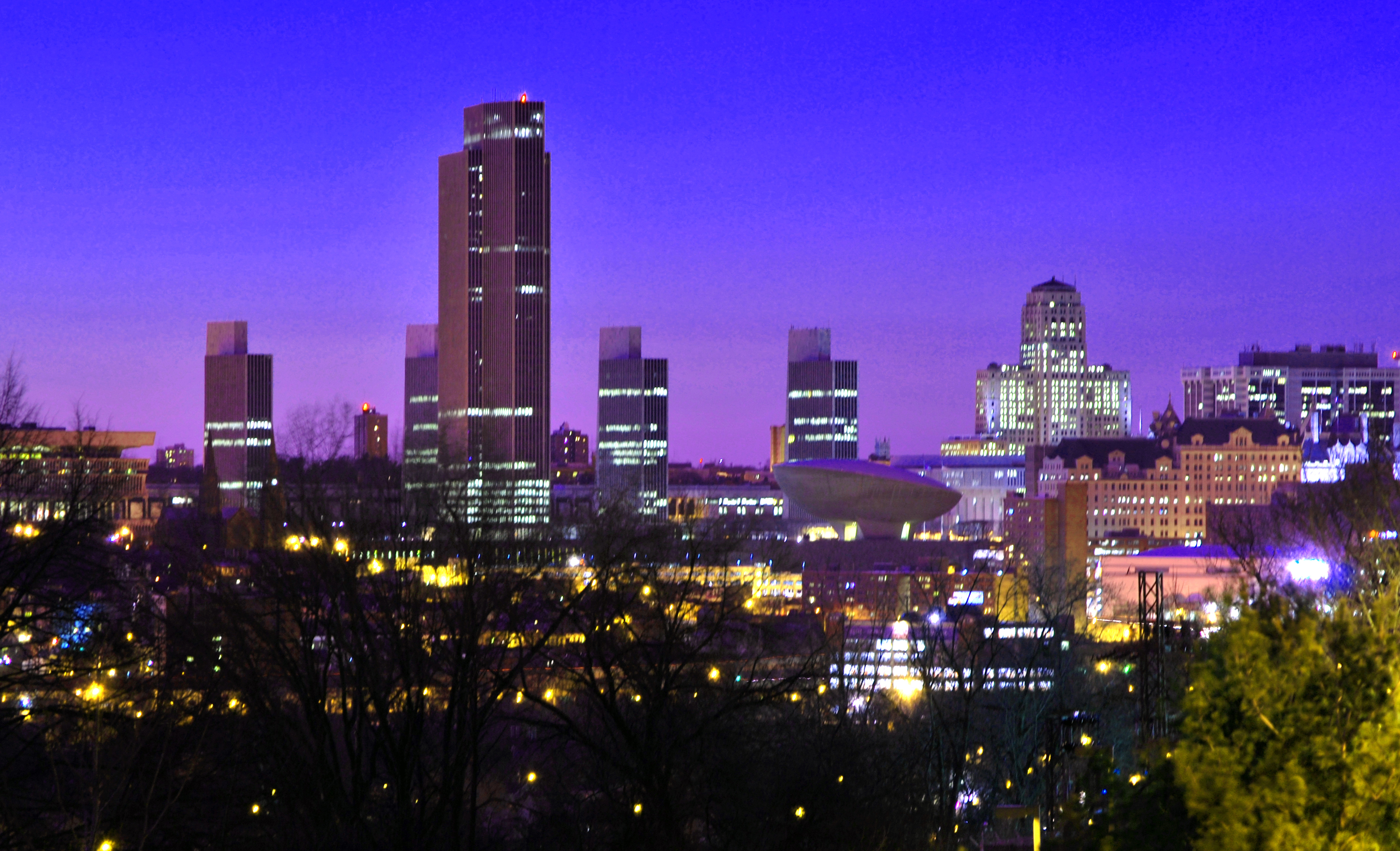
Cityscape
Architecture
Albany County has a myriad of different architectural styles spanning centuries of development.[40] Within the city of Albany alone there is Dutch Colonial (the Quackenbush House), French Renaissance (the New York State Capitol), Federal style (the original Albany Academy in Academy Park), Romanesque Revival (Albany City Hall), Art deco (the Alfred E. Smith Building), and Modern (Empire State Plaza). The cities of Albany, Cohoes, and Watervliet and the village of Green Island are more urban in architecture; while the towns of Colonie, Guilderland, New Scotland, and Bethlehem more suburban and the remaining Hilltowns (Berne, Knox, Westerlo, and Rensselaerville) very rural.
Parks
Albany County is home to the Emma Treadwell Thacher Nature Center, which opened in July 2001 and is located near the shore of Thompson's Lake between the two state parks that are in Albany County- Thompson's Lake State Park and John Boyd Thacher State Park. There are also state-owned nature preserves with interactive educational programs such as the Five Rivers Environmental Education Center and the Albany Pine Bush. The cities, towns, and villages of Albany County have many municipal parks, playgrounds, and protected green areas. Washington Park in the city of Albany and The Crossing in the town of Colonie are two of the largest. There are many small hiking and biking trails and longer distance bike-hike trails such the Mohawk-Hudson Bike-Hike Trail which goes from the city of Albany north to Cohoes and then west along the Mohawk River to Schenectady County.
Festivals
One of the largest events in Albany County is the Tulip Fest held in the city of Albany every spring at Washington Park. The tradition stems from when Mayor Erastus Corning 2nd had a city ordinance passed declaring the tulip as Albany's official flower on July 1, 1948.[41] The African-American tradition of Pinksterfest, whose origins are traced back even further to Dutch festivities, was later incorporated into the Tulip Fest. The Albany LatinFest has been held since 1996 and drew 10,000 to Washington Park in 2008.[42] PolishFest is a three day celebration of Polish culture in the Capital District, held in the town of Colonie for the past eight years.[43]
Amusement
Albany County has two shopping malls that are classified as super-regional malls (malls with over 800,000 sq ft),[44] Crossgates Mall in Guilderland and Colonie Center in Colonie with over one million square feet of rentable space in each. A regional mall, the Latham Circle Mall, is in Latham (town of Colonie). South of the Latham Circle Mall, in the neighboring hamlet of Newtonville also within the town of Colonie, is Hoffman's Playland. Hoffman's is a children's amusement park open during the summer. During the winter there are over 18 miles (29 km) of official trails for snowshoeing at the Albany Pine Bush Preserve, in the city of Albany and towns of Colonie and Guilderland.[45]
 Albany, the county's namesake and largest city
Municipalities
See also: Timeline of town creation in New York's Capital DistrictAlbany County is composed of three cities and 10 towns. Albany, Cohoes, and Watervliet are the three cities. The ten towns are Berne, Bethlehem, Coeymans, Colonie, Green Island, Guilderland, Knox, New Scotland, Rensselaerville, and Westerlo. Additionally there are six villages within five towns. The town of Colonie has two villages, one also named Colonie and one named Menands. The town of Green Island is coterminous with the village of the same name. Ravena is within the town of Coeymans, Altamont in the town of Guilderland, and Voorheesville in the town of New Scotland. Albany is the second oldest city in the state of New York based on date of incorporation as a city. All towns in Albany County were created from the town of Watervliet or from a town created from the town of Watervliet.
Culture and contemporary life
Albany is often derided as "Smallbany" (also spelled Smalbany) for its perceived lack of culture and as a backwater in tourism circles,[46] even though it consistently ranks high on lists of top cities/metro areas for culture, such as being 23rd in the book Cities Ranked & Rated.[47] Albany is home to some of the oldest museums, historical sites, and places of worship in the state of New York and the United States; some of the finest collections of historical artifacts and art can be found in Albany County.
Museums
Albany County has many historical sites and museums covering a wide-range of topics and time periods. The Albany Institute of History and Art founded in 1791 is one of the oldest museums in the United States,[48] and the New York State Museum is the oldest and largest state museum in the country.[49] Many of the museums are historical sites themselves, such as Cherry Hill, the Ten Broeck Mansion, and the Schuyler Mansion in the city of Albany and the Pruyn House in Colonie. The Quackenbush House is the second oldest house in the city of Albany and is part of the Albany Heritage Area Visitors Center, which includes a planetarium. The Albany Pine Bush Discovery Center in the city of Albany includes hands-on activities to learn about the unique Pine Bush Barrens of the city of Albany and towns of Guilderland and Colonie. Covering the history of pharmacy is the Throop Drug Store Museum at the Albany College of Pharmacy. The USS Slater, DE-766 is a World War II Destroyer Escort, the last floating Destroyer Escort, owned by the Destroyer Escort Historical Museum is moored from Spring to Fall at the foot of Quay Street in the Hudson River. The ship is open for tours each week and contains an excellent and well-maintained collection of World War II US Naval artifacts. www.ussslater.org
There are several art museums in Albany County; including the Albany Center Gallery, in downtown Albany, which exhibits works by local artists within a 100-mile (160 km) radius of that city;[50] the University Art Museum, at the University at Albany, SUNY; and the Opalka Gallery, at the Sage College of Albany. The Empire State Plaza in Albany has one of the most important state collections of modern art in the U.S. [51]
Performing arts
Albany County itself owns the largest venue for performing arts in the county, the Times Union Center, which was originally built as the Knickerbocker Arena; it opened on January 30, 1990 with a performance by Frank Sinatra.[52] In 1996, the The Grateful Dead released a concert album from their March 1990 performances titled Dozin' at the Knick.[53]
Sports
Many athletes and coaches in major sports have begun their careers in Albany County. NBA head coach of the Los Angeles Lakers Phil Jackson won his first championship ring when he guided the Albany Patroons to the 1984 CBA championship. Three years later, the Patroons completed a 50–6 regular season, including winning all 28 of their home games; at that time, Denver Nuggets head coach George Karl was the Patroons' head coach. Future NBA stars Mario Elie and Vincent Askew were part of that season's squad. Mike Tyson received his early training in the Capital District and his first professional fight was in Albany in 1985 and Tyson's first televised fight was in Troy in 1986. He fought professionally four times in Albany and twice each in Troy and Glens Falls between 1985 and 1986.
Since 1988, the Siena College men's basketball team (the Siena Saints) have appeared in six NCAA Tournaments (1989, 1999, 2002, 2008, 2009, and 2010).
Religious life
Albany County is home to one of the few Karaite Jewish communities outside Israel. This community is active and has its own synagogue.[54]
Demographics
As of the census[55] of 2000, there were 294,565 people, 120,512 households, and 70,981 families residing in the county. The population density was 563 people per square mile (217/km²). There were 129,972 housing units at an average density of 248 per square mile (96/km²). The racial makeup of the county was 63.19% White, 31.08% Black or African American, 0.21% Native American, 2.75% Asian, 0.03% Pacific Islander, 1.05% from other races, and 1.70% from two or more races. 3.08% of the population were Hispanic or Latino of any race. 19.2% were of Irish, 16.0% Italian, 11.0% German, 6.1% English and 5.1% Polish ancestry according to Census 2000 [1] . 90.4% spoke English, 2.7% Spanish and 1.0% Italian as their first language.
There were 120,512 households out of which 27.9% had children under the age of 18 living with them, 43.2% were married couples living together, 12.2% had a female householder with no husband present, and 41.1% were non-families. 33.0% of all households were made up of individuals and 11.3% had someone living alone who was 65 years of age or older. The average household size was 2.32 and the average family size was 2.99.
In the county the population was spread out with 22.6% under the age of 18, 11.3% from 18 to 24, 28.8% from 25 to 44, 22.8% from 45 to 64, and 14.5% who were 65 years of age or older. The median age was 37 years. For every 100 females there were 91.7 males. For every 100 females age 18 and over, there were 87.8 males.
The median income for a household in the county was $42,935, and the median income for a family was $56,724. Males had a median income of $39,838 versus $30,127 for females. The per capita income for the county was $23,345. About 7.2% of families and 10.6% of the population were below the poverty line, including 12.9% of those under age 18 and 7.3% of those age 65 or over.
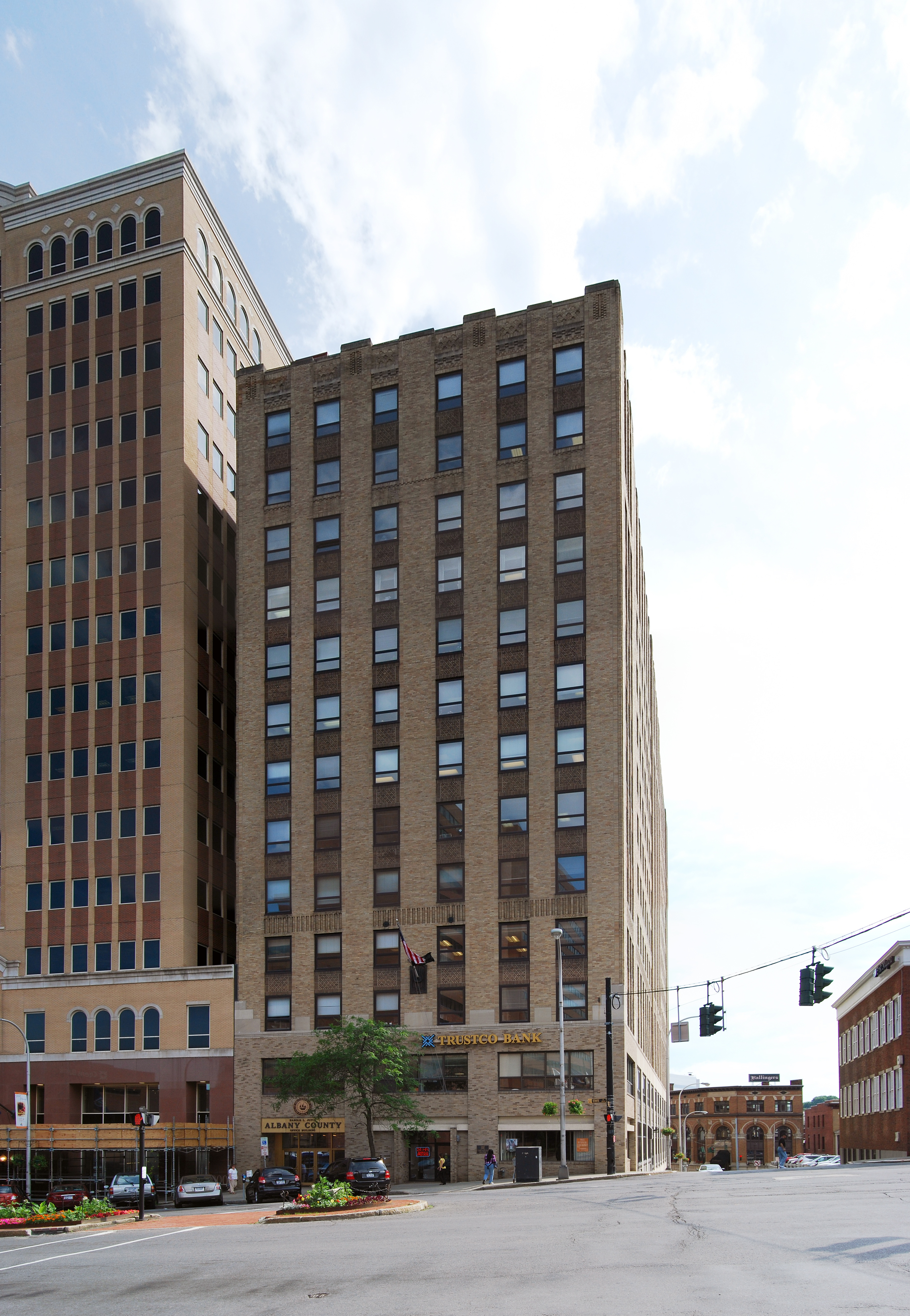
Government and politics
 Albany County office building on State Street in Albany
Albany County was governed by a board of supervisors until 1967. On January 1, 1968 a 39 member County Legislature came in to being. On January 1, 1976, Albany County government was revised once more when a new county charter went into effect with provisions for a county executive along with a 39-seat county legislature.[56] All 39 members are elected from individual districts. Currently, there are 31 Democrats and 8 Republicans. The current County Executive is Michael G. Breslin (D) and the Chair of the Legislature is Daniel P. McCoy (D). Other county elected officials include County Sheriff James Campbell, County District Attorney David Soares, and County Comptroller Michael F. Conners. The county executive is elected in a countywide vote.
Albany County Executives Name Party Term James J. Coyne, Jr. Democrat January 1, 1976 – December 31, 1991 Michael J. Hoblock Republican January 1, 1992 – December 31, 1994 Michael G. Breslin Democrat January 1, 1995 – Albany County Legislature District Legislator Party Residence 1 George L. Infante Democrat Albany 2 Lucille McKnight Democrat Albany 3 Wanda Willingham Democrat Albany 4 Virginia Maffia-Tobler Democrat Albany 5 Norma Chapman Democrat Albany 6 Christopher T. Higgins Democrat Albany 7 Brian Scavo Democrat Albany 8 Douglas Bullock Democrat Albany 9 Donald Rahm Democrat Albany 10 Daniel P. McCoy chairman Democrat Albany 11 Gary Domalewicz Democrat Albany 12 Frank Commisso majority leader Democrat Albany 13 William M. Clay Democrat Albany 14 Raymond Joyce Democrat Albany 15 Phillip Steck Democrat Loudonville 16 Robert Beston Democrat Watervliet 17 Sean E. Ward Democrat Green Island 18 Shawn Morse Democrat Cohoes 19 Gilbert Ethier Democrat Cohoes 20 Timothy Nichols Democrat Latham 21 David Mayo Democrat Latham 22 Patrick Timmins Democrat Albany 23 Peter Tunny Republican Niskayuna 24 Carl Zeilman Republican Albany 25 Ryan Horstmyer Democrat Loudonville 26 William Hoblock Republican Loudonville 27 Patrice Lockart Republican Albany 28 Christine Benedict minority leader Republican Albany 29 Lee Carman Republican Schenectady 30 Bryan Clenahan Democrat Albany 31 William Aylward Democrat Altamont 32 Mary Lou Connolly Democrat Albany 33 Herbert W. Reilly Democrat Voorheesville 34 Thomas Cotrofeld Democrat Delmar 35 Charles S. Dawson Democrat Glenmont 36 Richard Mendick Republican Selkirk 37 Peter Clouse Republican Coeymans 38 Charles Houghtaling Democrat Feura Bush 39 Alexander Gordon Democrat Berne Educational institutions
- Albany College of Pharmacy
- Albany Law School
- Albany Medical College
- Bryant & Stratton College
- Excelsior College
- The College of Saint Rose
- Sage College of Albany
- Sage Graduate School
- Siena College
- State University of New York at Albany
Transportation
Albany County has long been at the forefront of transportation technology from the days of turnpikes and plank roads to the Erie Canal, from the first passenger railroad in the state to the oldest municipal airport in the United States. Today, Interstates, Amtrak, and the Albany International Airport continue to make the Albany County a major crossroads of the Northeastern United States.
The Capital District Transportation Committee (CDTC) is the Metropolitan Planning Organization (MPO) for the Albany-Schenectady-Troy Metropolitan Statistical Area (MSA). Every metropolitan area in the United States with a population of over 50,000 must have a MPO in order to get any federal transportation funding. The US Department of Transportation (USDOT) uses an MPO to make decisions on what projects are most important to a metro area for immediate versus long term funding. The USDOT will not approve federal funds for transportation projects unless they are on an MPO's list.[57]
Interstate and other major highways
Albany County is situated at a major crossroads of the Northeastern United States. Even before the Interstate Highway System and the US Highway system, Albany County was the hub of many turnpikes and plank roads that connected the region. Today, it is in Albany County that Interstate 87 and Interstate 90 meet. The Thomas E. Dewey New York State Thruway is a toll-road that from Exit 24 in the city of Albany is I-87 and travels south to connect the county with downstate New York. West from Exit 24 the Thruway is I-90 and connects the county with Schenectady, Utica, Syracuse, Rochester, and Buffalo. North of Exit 24, I-87 is the Adirondack Northway and connects the city and county of Albany with their suburbs in Saratoga County and provides long-distance travel to Montreal. East of Exit 24, I-90 travels along the northern boundary of the city of Albany and exits the county on the Patroon Island Bridge into Rensselaer County to access Albany's eastern suburbs. Interstate 787 connects the Thruway (I-87) to Downtown Albany, Menands, Watervliet, and Cohoes. US Route 9 enters the county on the Dunn Memorial Bridge and travels through the city of Albany north connecting it with the suburbs in the Colonie and Saratoga County. US Route 20 also enters the county on the Dunn Memorial Bridge and then travels west through Albany (city) and then the town of Guilderland. New York State Route 5 and New York State Route 7 are two important highways that bisect the county and serve as important shopping strips.
Mass transit
Albany County is served by the Capital District Transportation Authority, a four county bus service that also serves Rensselaer, Schenectady, and Saratoga counties. Greyhound Lines, Trailways, and Peter Pan/Bonanza buses are all serve a downtown terminal. There is also a Chinatown bus service that leaves from Central Avenue and goes to Chinatown in Manhattan.
Airports
Albany International Airport is the only commercial airport in the county. Destinations for flights out of Albany include Toronto; Cleveland, Ohio; Atlanta, Georgia; Las Vegas; Chicago; Charlotte, North Carolina; and Orlando, Florida, among many others.
Rail
Since 1968 when Union Station in the city of Albany was abandoned for a new station across the Hudson in the city of Rensselaer, Albany County has been without a train station. Amtrak has several routes servicing the Albany-Rensselaer Station. The Adirondack (north to Montreal, Quebec and south to the city of New York), Empire Service (west to Buffalo and Niagara Falls, south to New York), Ethan Allen Express (northeast to Rutland, Vermont and south to New York), Maple Leaf (west to Toronto and south to New York), and the Lake Shore Limited (at Albany-Rensselaer separate routes from Boston and New York merge to one train west to Chicago, on way east one train splits to two, one east to Boston another south to New York).
See also
- List of counties in New York
- National Register of Historic Places listings in Albany County, New York
- List of people associated with Albany County, New York
- Albany County Sheriff's Department
Sources
- ^ "Henry Hill, New York". Peakbagger.com. November 1, 2004. http://www.peakbagger.com/peak.aspx?pid=7302. Retrieved 2009-08-28.
- ^ George Howell and Jonathan Tenney (1886). Bi-Centennial History of Albany. W.W. Munsell. p. 12. http://books.google.com/?id=HGkJAQAAIAAJ&printsec=frontcover&dq=history+of+albany+county&q=. Retrieved 2009-08-28.
- ^ a b George Howell and Jonathan Tenney (1886). Bi-Centennial History of Albany. W.W. Munsell. p. 70. http://books.google.com/?id=HGkJAQAAIAAJ&printsec=frontcover&dq=history+of+albany+county&q=. Retrieved 2009-08-28.
- ^ a b c George Howell and Jonathan Tenney (1886). Bi-Centennial History of Albany. W.W. Munsell. p. 71. http://books.google.com/?id=HGkJAQAAIAAJ&printsec=frontcover&dq=history+of+albany+county&q=. Retrieved 2009-08-28.
- ^ a b c David Kendall Martin (Fall 1990). "The Districts of Albany County, New York, 1772–1784". The New York Genealogical and Biographical Society. http://www.newyorkfamilyhistory.org/modules.php?name=Sections&op=viewarticle&artid=72. Retrieved 2009-08-30.
- ^ William Barnes (1851). The Settlement and Early History of Albany. Gould, Banks, & Gould. p. 17.
- ^ George Howell and Jonathan Tenney (1886). Bi-Centennial History of Albany. W.W. Munsell. p. 72. http://books.google.com/?id=HGkJAQAAIAAJ&printsec=frontcover&dq=history+of+albany+county&q=. Retrieved 2009-08-28.
- ^ John French (1860). Gazetteer of the State of New York. R. Pearsall Smith. p. 598. http://books.google.com/?id=R_zHwh4xByQC&printsec=frontcover&dq=gazetteer+new+york#v=onepage&q=saratoga%20county. Retrieved 2009-08-30.
- ^ "Albany County". New York State Museum. http://www.nysm.nysed.gov/albany/albanycounty.html. Retrieved 2009-08-30.
- ^ (state), New York (1788). Laws of the State of New York. State of New York. p. 748. http://books.google.com/?id=GBWxAAAAIAAJ&pg=PA748&dq=an+act+for+dividing+the+counties+of+this+state+into+towns&q=an%20act%20for%20dividing%20the%20counties%20of%20this%20state%20into%20towns. Retrieved 2009-08-31.
- ^ (N.Y. Col. Laws, ch 4/1:122)
- ^ a b Thorne, Kathryn Ford, Compiler & Long, John H., Editor: New York Atlas of Historical County Boundaries; The Newbury Library; 1993.
- ^ (N.Y. Col. Laws, ch 333/1:915).
- ^ (Cappon, Petchenik, and Long, 1, 77, 90; Shortt and Doughty, 119—120).
- ^ (Slade, 13—19; Van Zandt, 63).
- ^ (N.Y. Col. Laws, ch. 1297/4:904).
- ^ (N.Y. Col. Laws, ch. 1297/4:903).
- ^ (N.Y. Col. Laws, ch. 1559/5:400).
- ^ (N.Y. Col. Laws, ch. 1559/5:401).
- ^ (N.Y. Col. Laws, ch. 1534/5:321).
- ^ (N.Y. Col. Laws, ch. 1559/5:402).
- ^ (N.Y. Col. Laws, ch. 1665/5:662).
- ^ (N.Y. Col. Laws, ch. 1719/5:779).
- ^ (Slade, 70–73; Van Zandt, 64; C. Williamson, 82–84, map facing 95, 100–102, 112–113).
- ^ (Vt. State papers, 13:45–46).
- ^ (Vt. State papers, vol 3, pt. 2; pp. 67–68).
- ^ (N.Y. Laws 1786, 9th sess., ch. 28/p. 49).
- ^ (N.Y. Laws 1788, 11th sess., ch. 63/pp. 746–747).
- ^ (N.Y. Laws 1791, 14th sess., ch. 4/p. 201).
- ^ (N.Y. Laws 1795, 18th sess., ch. 42/p. 588).
- ^ (N.Y. Laws 1798,21st sess., ch. 93/p. 273).
- ^ (N.Y. Laws 1800, 23rd sess., ch. 59/p. 503).
- ^ (N.Y. Laws 1801,24th sess., ch. 123/p. 290).
- ^ (N.Y. Laws 1888, 111th sess., ch. 42/p. 85).
- ^ (N.Y. Laws 1808, 32nd sess., ch. 65, sec. 1/p. 458).
- ^ "Monthly Averages for Albany, NY". USTravelWeather.com. 2008. Archived from the original on 2008-06-11. http://web.archive.org/web/20080611112348/http://www.ustravelweather.com/weather-new-york/albany-weather.asp. Retrieved 2008-09-26.
- ^ a b "Climate information for Albany, New York". climate-zone.com. http://www.climate-zone.com/climate/united-states/new-york/albany/. Retrieved 2009-06-06.
- ^ "Cloudiness". University of Utah, Department of Atmospheric Sciences. http://www.met.utah.edu/jhorel/html/wx/climate/cldy.html. Retrieved 2009-06-06.[dead link]
- ^ "Sunshine Hours Page". http://www.thewellers.com/weller43/sunshine.htm. Retrieved 2009-06-06.
- ^ "Architecture". http://www.docstoc.com/docs/4936290/ARCHITECTURE-Architecture-ALBANY-COUNTY-If-architecture-is-your-passion. Retrieved 2009-08-26.
- ^ "Albany Tulip Queen". Albany Tulip Queen.com. http://www.albanytulipqueen.com/. Retrieved 2009-06-07.
- ^ "About Albany Latin Fest". Albany Latin Festival. http://www.albanylatinfest.com/about.html. Retrieved 2009-06-08.
- ^ "PolishFest'09". http://www.polishfest-ny.org/.
- ^ International Council of Shopping Centers Shopping Center Definitions for the U.S. Information accurate as of 2004. Retrieved February 20, 2007.
- ^ "Enjoy the Albany/Capital District on snowshoes". Albany.com. http://www.albany.com/winter/snowshoeing.cfm. Retrieved 2009-06-09.
- ^ Jeff Campbell (2008). USA. Lonely Planet. p. 184. ISBN 9781741046755. http://books.google.com/?id=JwvE1F2zyXoC&pg=PA184&dq=smallbany#PPA184,M1. Retrieved 2009-06-01.
- ^ "America's Top Cities for Culture". Move, Inc.. http://www.move.com/new-homes/real-estate-news/the-top-10-cultural-cities.aspx. Retrieved 2009-06-04.
- ^ The History of the Albany Institute of History from the 1700's to the Present
- ^ "Support the New York State Museum". New York State Museum. http://www.nysm.nysed.gov/membership/. Retrieved 2009-05-30.
- ^ "About Us". Albany Center Gallery. http://www.albanycentergallery.org/about/. Retrieved 2009-11-25.
- ^ "Plaza Art Collection". New York State Office of General Services. http://www.ogs.state.ny.us/visiting/cultural/toursArt.html. Retrieved 2009-05-29.[dead link]
- ^ "Times Union enters a new arena". Carol DeMare. Times Union. May 5, 2006
- ^ Dozin' at the Knick
- ^ http://www.orahsaddiqim.org/ Karaite Judaism in Albany County
- ^ "American FactFinder". United States Census Bureau. http://factfinder.census.gov. Retrieved 2008-01-31.
- ^ "3 MORE COUNTIES ADOPT CHARTERS". The New York Times (New York, New York): pp. 59. 1973-11-25
- ^ "Capital District Transportation Committee". Capital District Transportation Committee. http://www.cdtcmpo.org/whatcdtc.htm. Retrieved 2009-04-23.
Further reading
- Pearson, Jonathan; Arnold Johan Ferdinand Van Laer (translator and editor) (1869). Early Records of the City and County of Albany, and Colony of Rensselaerswyck (1656–1675). Joel Munsell. OCLC 59223937. http://books.google.com/?id=xZwCAAAAMAAJ.
-
- Note: Linked titles redirect to a free, full-view version hosted by Google Books or the Internet Archive.
External links
- Albany County official website
- Albany.com City Guide
- Albany County at the Open Directory Project
- Summary early history of Albany County, NY
- Early history of Albany County towns
- Albany Hilltowns is a One-Place Study on the history of the Albany County Hilltowns of Berne, Knox, Westerlo, and Rensselaerville, and the families that lived there.

Schenectady County Saratoga County Schoharie County 
Rensselaer County  Albany County, New York

Greene County Columbia County Capital District of New York Central communities Albany (History · City Hall · Coat of Arms) · Schenectady (City Hall) · Troy (History) · List of all incorporated places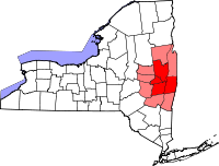
Largest communities
(over 20,000 in 2000)Medium-sized communities
(10,000 to 20,000 in 2000)City of Amsterdam · Brunswick · Cohoes · East Greenbush · Glens Falls · Gloversville · Halfmoon · Malta · North Greenbush · Schodack · Watervliet · WiltonSmall communities
(5,000 to 10,000 in 2000)Town of Amsterdam · Ballston Spa · Cobleskill · Village of Colonie · Duanesburg · City of Johnstown · Town of Johnstown · Kinderhook · Mechanicville · New Scotland · Rensselaer · Sand Lake · Scotia · Town of Stillwater · WaterfordCounties Albany · Columbia · Fulton · Greene · Montgomery · Rensselaer · Saratoga · Schenectady · Schoharie · Warren · WashingtonHistory Mohawks · Mahicans · Fort Orange · Rensselaerswyck · Beverwyck · Albany Plan of Union · Timeline of town creation · Toponymies of places · Tech ValleyGeography Hudson River (Valley) · Mohawk River · Erie Canal · Lake Albany · Lake George · Albany Pine Bush (Rensselaer Lake · Woodlawn Preserve) · Adirondack Mountains · Catskill Mountains · Rensselaer PlateauReligion and culture Culture in New York's Capital District · Sports in New York's Capital District · Episcopal Diocese of Albany · Roman Catholic Diocese of AlbanyEducation Public school districtsList of school districts in New York's Capital DistrictHigher educationNewspapers TV/Radio Broadcast television in the Capital District Local stations WRGB (6.1 CBS, 6.2 This TV) • WTEN (10.1 ABC, 10.2 Weather, 10.3 RTV) • WNYT (13.1 NBC, 13.2 Weather, 13.3 Weather Radar) • WMHT (17.1 PBS, 17.2 ThinkBright, 17.3 HD) • WXXA (23.1 Fox, 23.2 The Cool TV) • WNGN-LP 35 / WNGX-LP 42 (FN) • WCWN (45.1 The CW, 45.2 Uni Sp) • WNYA / WNYA-CD (51.1 MNTV, 51.2 Antenna TV) • W52DF 52 (silent)
Outlying area stations WVBK-CA 2 (RSN' Manchester, VT) • W04AJ 4 (PBS; Glens Falls) • W04BD 4 (PBS; Schoharie) •
WNCE-CA 8 (A1; Glens Falls) • WYBN-CA 14 (RSN; Cobleskill) • WCDC (19.1 ABC; Adams, MA) • WVBG-LP 25 (RSN; Greenwich) • W36AX 36 (PBS / VPT; Manchester, VT) • W47CM 47 (silent; Glens Falls) • WYPX (55.1 Ion, 55.2 qubo, 55.3 Life; Amsterdam) • W53AS 53 (PBS / VPT; Bennington, VT)Adjacent locals Cable-only stations YNN Capital Region • TW3 • YES • SNY • MSG Network
Defunct stations New York State television: Albany/Schenectady • Binghamton • Buffalo • Burlington/Plattsburgh • Elmira • New York City • Rochester • Syracuse • Utica • Watertown
Vermont Broadcast television: Albany/Schenectady • Boston, MA • Burlington/Plattsburgh
Massachusetts television: Albany • Boston • Providence • Springfield
Radio stations in the Albany / Schenectady / Troy market by FM frequency 88.3 · 89.1² · 89.7 · 89.9 · 90.3/93.1² · 90.7/94.9 · 90.7 · 90.7 · 90.9 · 91.1 · 91.5 · 92.3 · 92.9 · 93.5 · 93.7 · 94.5 · 94.7 · 95.5 · 95.9 · 96.3 · 96.7 · 97.3 · 97.5 · 97.7 · 97.9 · 98.3² · 98.5 · 98.5 · 99.1 · 99.5² · 100.3 · 100.9 · 101.3 · 101.7 · 101.9 · 102.3² · 102.7 · 103.1² · 103.5 · 103.9 · 104.5 · 104.9 · 105.7² · 106.1 · 106.5² · 107.1 · 107.7²by AM frequency NOAA Weather Radio frequency 162.550by callsign W226AC · W235AY · W256BU · W291BY · WABY · WAJZ · WAMC (AM) · WAMC-FM² · WBAR · WBPM · WCDB · WCKL · WCKM · WCQL · WCSS · WCTW · WDCD · WDCD-FM · WDDY² · WENT · WEQX · WEXT · WFFG · WFLY · WFNY · WGDJ · WGNA² · WGXC · WGY¹² · WGY-FM² · WHAZ · WHAZ-FM · WHUC · WHVP · WIZR · WJIV · WKBE · WKKF² · WKLI · WLJH · WMHT² · WMYY · WNYQ · WOFX² · WOPG · WPGL · WPYX² · WQAR · WQBJ · WQBK · WQSH² · WRIP · WROW · WRPI · WRUC · WRVE² · WSDE · WTMM · WTRY² · WUAM · WVCR · WVKZ · WVTL · WXL34 · WYAI · WYJB · WYKV · WZCR · WZMRDefunct stations New York Radio Markets: Albany-Schenectady-Troy • Binghamton • Buffalo-Niagara Falls • Elmira-Corning • Hamptons-Riverhead • Ithaca • Nassau-Suffolk (Long Island) • New York City • Newburgh-Middletown (Mid Hudson Valley) • Olean • Plattsburgh • Poughkeepsie • Rochester • Syracuse • Utica-Rome • Watertown
Other New York Radio Regions: Jamestown-Dunkirk • North Country • Saratoga
See also: List of radio stations in New YorkMunicipalities and communities of Albany County, New York Cities Albany | Cohoes | Watervliet
Towns Berne | Bethlehem | Coeymans | Colonie | Green Island | Guilderland | Knox | New Scotland | Rensselaerville | Westerlo
Villages Altamont | Colonie | Green Island | Menands | Ravena | Voorheesville
CDPs Other
hamletsAlcove | Boght Corners | Clarksville | Crescent Station | Dunsbach Ferry | Elsmere | Feura Bush | Fort Hunter | Fullers | Glenmont | Guilderland | Guilderland Center | Karner | Latham | Lisha Kill | Loudonville | Mannsville | McKownville | New Salem | Newtonville | Normansville | Roessleville | Selkirk | Slingerlands | South Bethlehem | Verdoy | West Albany
Categories:- Albany County, New York
- States and territories established in 1683
- New York counties


Wikimedia Foundation. 2010.