- Geography of Madagascar
-
Madagascar Nickname: The Red Island 
Satellite image of Madagascar
Geography Location Indian Ocean Coordinates 20°00′S 47°00′E / 20°S 47°ECoordinates: 20°00′S 47°00′E / 20°S 47°E Area 587,040 km2 (226,657 sq mi) Area rank 4th Coastline 4,828 km (3,000 mi) Highest elevation 2,876 m (9,436 ft) Highest point Maromokotro Country MadagascarLargest city Antananarivo (pop. 1,403,449) Demographics Population 20,042,551 (as of 2008) Density 33 /km2 (85 /sq mi) Ethnic groups Malayo-Indonesian (Merina and related Betsileo), Côtiers (mixed African, Malayo-Indonesian, and Arab ancestry - Betsimisaraka, Tsimihety, Antaisaka, Sakalava), French, Desi, Creole, Comorian, Chinese Madagascar is an island in the Indian Ocean off the eastern coast of southern Africa, east of Mozambique. It is the fourth largest island in the world. The highest point is Maromokotro, in the Tsaratanana Massif region in the north of the island, at 2,876 metres (9,436 ft). The capital Antananarivo is in the Hauts Plateaux near the centre of the island. It has a total area of 587,040 square kilometres (226,660 sq mi) with 581,540 square kilometres (224,530 sq mi) of land and 5,500 square kilometres (2,100 sq mi) of water.
Madagascar originated as part of the Gondwana supercontinent. Its west coast was formed when Africa broke off from Gondwana around 165 million years ago. Madagascar eventually broke off from India about 65 million years ago.
Contents
Geographical regions
Madagascar can be divided into five general geographical regions: the east coast, the Tsaratanana Massif, the central highlands, the west coast, and the southwest. The highest elevations parallel the east coast.
 Land coverage (left) and topographical (right) maps of Madagascar.
East coast
The east coast consists of a narrow band of lowlands about one kilometer wide, formed from the sedimentation of alluvial soils, and an intermediate zone composed of steep bluffs alternating with ravines bordering an escarpment of about 500 metres (1,640 ft) in elevation, which gives access to the central highlands. The coastal region extends roughly from north of Baie d'Antongil, the most prominent feature on the east coast of the island formed by the Masoala Peninsula, to the far north of the island. The coastline is straight, with the exception of a bay, offering less in the way of natural harbors than the west coast. The Canal des Pangalanes (Lakandranon' Ampalangalana), an 800-kilometre (497 mi)-long lagoon formed naturally by the washing of sand up on the island by the Indian Ocean currents and by the silting of rivers, is a feature of the coast; it has been used both as a means of transportation up and down the coast and as a fishing area. The beach slopes steeply into deep water. The east coast is considered dangerous for swimmers and sailors because of the large number of sharks that frequent the shoreline.
Tsaratanana Massif
The Tsaratanana Massif region at the north end of the island contains, at 2,880 metres (9,449 ft), the highest point on the island. Further north is the Montagne d'Ambre (Ambohitra), which is of volcanic origin. The coastline is deeply indented; two prominent features are the natural harbor at Antsiranana (Diégo Suarez), just south of the Cap d'Ambre (Tanjon' i Bobaomby), and the large island of Nosy-Be to the west. The mountainous topography to the south, however, limits the potential of a port at Antsiranana by impeding the flow of traffic from other parts of the island.
Central highlands
 Village in the central highlands.Main article: Central Highlands (Madagascar)
The central highlands, which range from 800 to 1,800 m (2,625 to 5,906 ft) in altitude, contain a wide variety of topographies: rounded and eroded hills, massive granite outcrops, extinct volcanoes, eroded peneplains, and alluvial plains and marshes, which have been converted into irrigated rice fields. The central highlands extend from the Tsaratanana Massif in the north to the Ivakoany Massif in the south. They are defined rather clearly by the escarpments along the east coast, and they slope gently to the west coast. The central highlands include the Anjafy High Plateaux; the volcanic formations of Itasy (Lake Itasy is in a volcanic crater) and the Ankaratra Massif, reaching a height of 2,643 m (8,671 ft). The Isalo Roiniforme Massif lies between the central highlands and the west coast.
Antananarivo, the national capital, is located in the northern portion of the central highlands at 1,276 m (4,186 ft) above sea level. A prominent feature of the central highlands is a rift valley running north to south, located east of Antananarivo and including Lac Alaotra, the largest body of water on the island, having a length of 40 km (25 mi). The lake is located 761 m (2,497 ft) above sea level and is bordered by two cliffs, rising 701 m (2,300 ft) to the west and 488 m (1,601 ft) to the east, which form the walls of a valley. This region has experienced geological subsidence, and earth tremors are frequent.
West coast
The west coast, composed of sedimentary formations, is more indented than the east coast, thus offering a number of harbors sheltered from cyclones, such as the harbor at Mahajanga. Deep bays and well-protected harbors have attracted explorers, traders, and pirates from Europe, Africa, and the Middle East since ancient times; thus, the area has served as an important bridge between Madagascar and the outside world. Silting up of harbors on this coast, caused by sediment from the high levels of erosion suffered inland in Madagascar, is a major problem. The broad alluvial plains found on the coast between Mahajanga (Majunga) and Toliara (Tuléar), which are believed to have great agricultural potential, are thinly inhabited, in many places covered with swamps of Madagascar mangroves, and remain largely unexplored, although they are the subject of mineral and hydrocarbon exploration activity. The giant oil fields of Tsimiroro (heavy oil) and Bemolanga (ultra heavy oil) lie towards the west of the island.
Southwest
The southwest is bordered on the east by the Ivakoany Massif and on the north by the Isala Roiniforme Massif. It includes 1 regions along the south coast, the Mahafaly Plateau and the desert region occupied by the Antandroy people.
Rivers and lakes
The Mananara and Mangoro rivers flow from the central highlands to the east coast, as does the Maningory, which flows from Lake Alaotra. Other rivers flowing east into the Indian Ocean include the Bemarivo, the Ivondro, and the Mananjary. These rivers tend to be short because the watershed is located close to the east coast. Owing to the steep elevations, they flow rapidly, often over spectacular waterfalls.
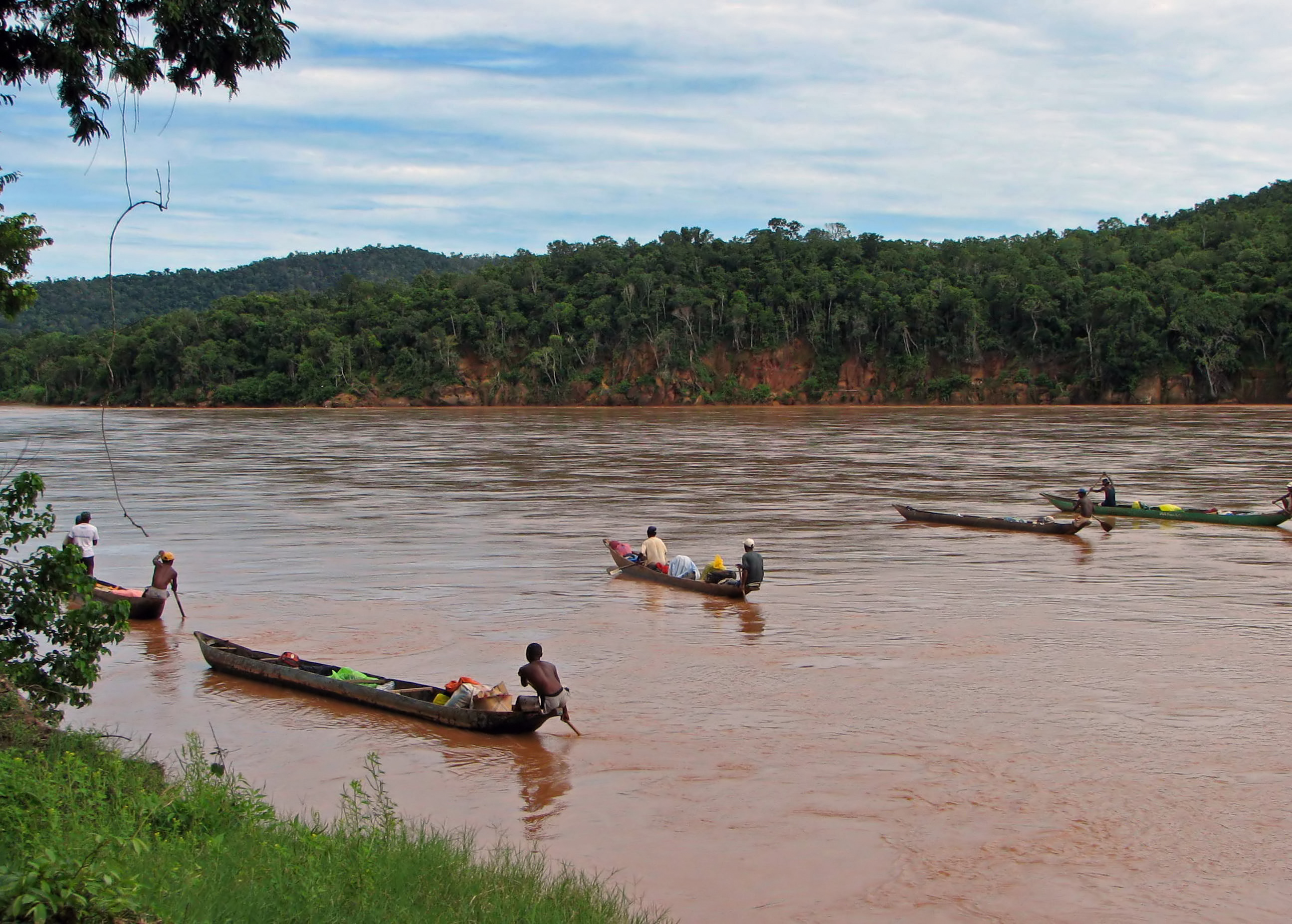
The rivers flowing to the west coast and emptying into the Mozambique Channel tend to be longer and slower because of the more gradual slope of the land. The major rivers on the west coast are the Sambirano, the Mahajamba, the Betsiboka (the port of Mahajanga is located at the mouth), the Mania, the North and South Mahavavy, the Mangoky, and the Onilahy. The Ikopa, which flows past Antananarivo, is a tributary of the Betsiboka. The Mangoky River has a basin area of some 50,000 square kilometers (19,305 sq mi); the Ikopa River and the Betsiboka River have basin areas of 18,550 and 11,800 square kilometers (7,162 and 4,556 sq mi) a basin area of some 12,435 square kilometers (4,801 sq mi), but it runs dry during certain months in this desert region.
Important lakes, aside from Alaotra, include Lake Kinkony in the northwest and Lake Ihotry in the southwest.
-

Majahilo river at Miandrivazo.
-

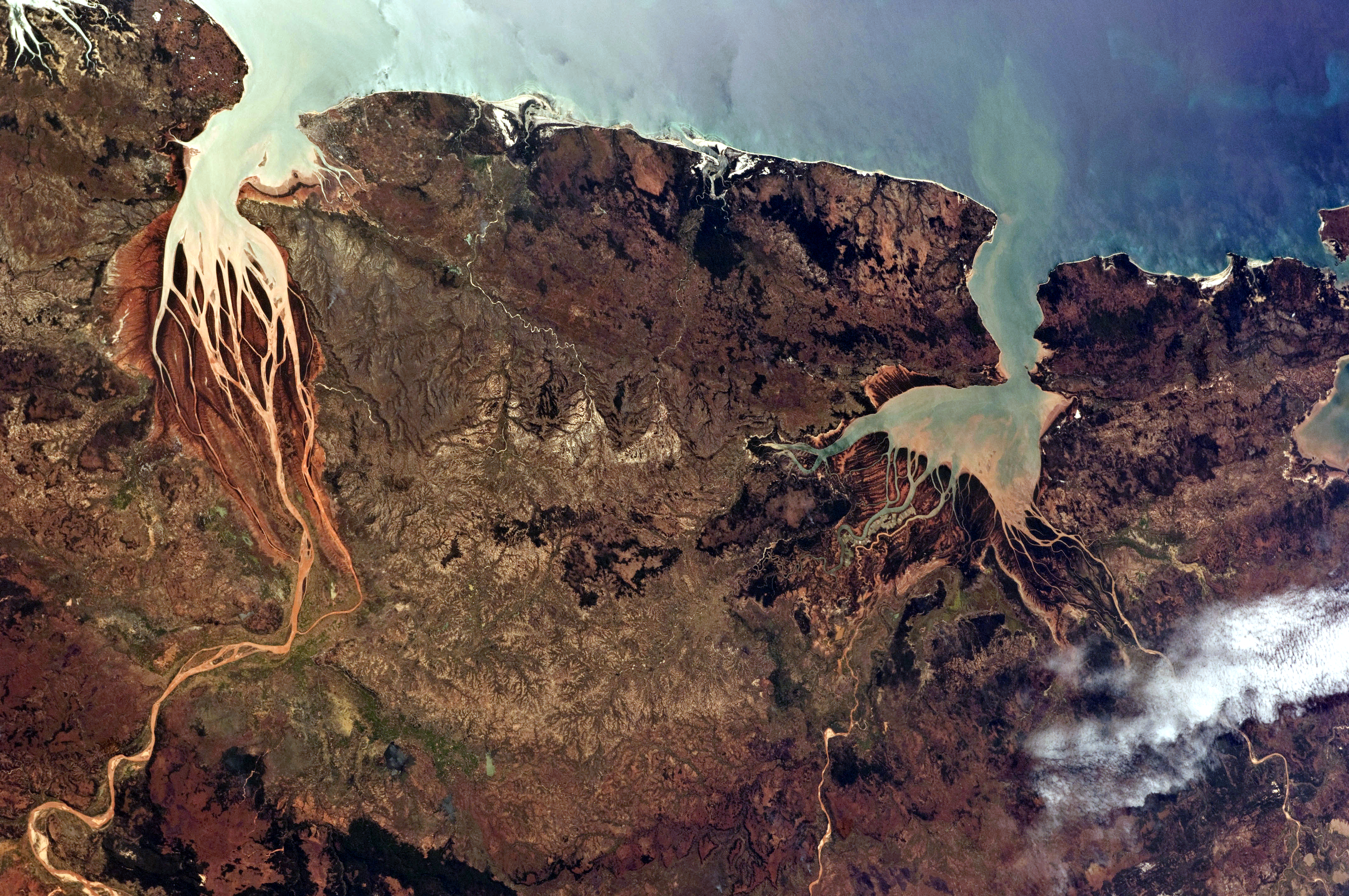
This astronaut photograph highlights two estuaries along the north-western coastline of Madagascar.
-

Tsiribihina River.
-

Lake Tritriva
Soils
Madagascar has been called the "Great Red Island" because of the prominence of red lateritic soils. The red soils predominate in the central highlands, although there are much richer soils in the regions of former volcanic activity, Itasy and Ankaratra, and Tsaratanana to the north. A narrow band of alluvial soils is found all along the east coast and at the mouths of the major rivers on the west coast; clay, sand, and limestone mixtures are found in the west; and shallow or skeletal laterite and limestone are located in the south. Deforestation and grazing mean that the soils suffer from aggressive erosion in many locations.
Climate
The climate is tropical along the coast, temperate inland, and arid in the south. The weather is dominated by the southeastern trade winds that originate in the Indian Ocean anticyclone, a center of high atmospheric pressure that seasonally changes its position over the ocean. Madagascar has two seasons: a hot, rainy season from November to April; and a cooler, dry season from May to October. There is, however, great variation in climate owing to elevation and position relative to dominant winds. The east coast has a subequatorial climate; being most directly exposed to the trade winds it has the heaviest rainfall, averaging as much as 3,500 mm (137.8 in) annually. This region is notorious for a hot, humid climate in which tropical fevers are endemic and also for the destructive cyclones that occur during the rainy season, coming in principally from the direction of the Mascarene Islands. Because rain clouds discharge much of their moisture east of the highest elevations on the island, the central highlands are appreciably drier and, owing to the altitude, also cooler. Thunderstorms are common during the rainy season in the central highlands.
Antananarivo receives practically all of its average annual 1,400 mm (55.1 in) of rainfall between November and April. The dry season is pleasant and sunny, although somewhat chilly, especially in the mornings. Although frosts are rare in Antananarivo, they are common at higher elevations.
Although hail falls on many of the higher areas of the island (including Antananarivo), there is no snowfall except on the Ankaratra massif where above 2,400 m (7,874 ft) it may occasionally fall and even remain for several days.
The west coast is drier than either the east coast or the central highlands because the trade winds lose their humidity by the time they reach this region. The southwest and the extreme south are semidesert; as little as 330 mm (13 in) of rain falls annually at Toliara. Overall, surface water is most abundant along the east coast and in the far north (with the exception of the area around Cap d'Ambre, which has relatively little surface water). Amounts diminish to the west and south, and the driest regions are in the extreme south.
Madagascar occasionally experiences the impact of cyclones. February 2-4, 1994, Madagascar was struck by Cyclone Geralda, the worst cyclone to come ashore on the island since 1927. The cyclone killed seventy people and destroyed enough property to leave approximately 500,000 homeless, including 30,000 in Antananarivo and 80,000 in Toamasina. The cyclone also significantly damaged the country's infrastructure, most notably coastal roads, railroads, and telecommunications, as well as agriculture. Damage was estimated at US$45 million.
Flora and fauna
See also: List of mammals of MadagascarThe island of Madagascar has been described as an "alternate world" or a "world apart" because of the uniqueness and rarity of many of its plant and animal species. Their characteristics are believed to reflect the island's origins as a part of Gondwanaland and its many millions of years of isolation following the breakup of the landmass. Thus certain plants, including the traveler's tree (so called because its trunk holds potable water), are found both in Madagascar and on the South American continent, but not in Africa.
Many of the characteristic African species, large mammals as the elephant, rhinoceros, giraffe, zebra, and antelope and predators such as lions and leopards, do not exist in Madagascar. In addition, the island has been spared the great variety of venomous snakes indigenous to the African continent. Although it is assumed that most life forms on the island had an African (or South American) origin, isolation has allowed old species—elsewhere extinct—to survive and new species unique to the island to evolve. Thus, a great number of plant, insect, reptile, and fish species are endemic to Madagascar, and all indigenous land mammal species—66 in all—are unique to the island.
Madagascar was once covered almost completely by forests, but slash and burn practices for dry rice cultivation has denuded most of the landscape, especially in the central highlands. Rain forests are concentrated on the steep hillsides along a slender north-south axis bordering the east coast, from the Tsaratanana Massif in the north to Tolagnaro in the south. Secondary growth, which has replaced the original forest and consists to a large extent of traveller's trees, raffia palm, and baobabs, is found in many places along the east coast and in the north. The vegetation of the central highlands and the west coast is for the most part savanna or steppe, and coarse prairie grass predominates where erosion has not exposed the orange-red lateritic soil. In the southwest, the vegetation is adapted to desert conditions.
The remaining rain forest contains a great number of unique plant species. The country has some 900 species of orchid. Bananas, mangoes, coconut, vanilla, and other tropical plants grow on the coasts, and the eucalyptus tree, brought from Australia, is widespread.
Wood and charcoal from the forests are used to meet 80% of domestic fuel needs. As a result, wood has become scarce. The World Bank in 1990 launched an environmental program that has increased the planting of pine and eucalyptus to satisfy fuel needs.
Natural resources
Madagascar has a number of natural resources, including graphite, chromite, coal, bauxite, salt, quartz, tar sands, semi-precious stones and mica. There are also fishing areas offshore and potential for hydropower. In 2001, it was estimated that 5.07% of the land area was used for arable land, 1.03% had permanent crops. Twenty-six percent of the land is forested. The majority of the population depend on subsistence farming, largely rice and cattle. The manufacturing sector is small but growing.
Environmental issues
Madagascar is currently suffering in some areas from soil erosion as a result of deforestation and overgrazing, desertification, and contamination of surface water with raw sewage and organic waste. Several species of flora and fauna that are unique to the islands are endangered. Regular cyclones cause flooding in low lying coastal regions.
Extreme points
This is a list of the extreme points of Madagascar, the points that are farther north, south, east or west than any other location.
- Northernmost Point - Cap D'Ambre, Antsiranana Province
- Easternmost Point - Ile Ngontsy, Antsiranana Province
- Easternmost point (mainland) - Cap Est, Antsiranana Province
- Southernmost Point - Cape Vohimena (Cap Sainte Marie), Toliara Province
- Westernmost Point - Pointe Mananonoka, Toliara Province
See also
References
 This article incorporates public domain material from websites or documents of the Library of Congress Country Studies.
Sovereign
states- Algeria
- Angola
- Benin
- Botswana
- Burkina Faso
- Burundi
- Cameroon
- Cape Verde
- Central African Republic
- Chad
- Comoros
- Democratic Republic of the Congo
- Republic of the Congo
- Côte d'Ivoire (Ivory Coast)
- Djibouti
- Egypt
- Equatorial Guinea
- Eritrea
- Ethiopia
- Gabon
- The Gambia
- Ghana
- Guinea
- Guinea-Bissau
- Kenya
- Lesotho
- Liberia
- Libya
- Madagascar
- Malawi
- Mali
- Mauritania
- Mauritius
- Morocco
- Mozambique
- Namibia
- Niger
- Nigeria
- Rwanda
- São Tomé and Príncipe
- Senegal
- Seychelles
- Sierra Leone
- Somalia
- South Africa
- South Sudan
- Sudan
- Swaziland
- Tanzania
- Togo
- Tunisia
- Uganda
- Zambia
- Zimbabwe
States with limited
recognition- Sahrawi Arab Democratic Republic
- Somaliland
Dependencies and
other territories- Canary Islands / Ceuta / Melilla / Plazas de soberanía (Spain)
- Madeira (Portugal)
- Mayotte / Réunion (France)
- Saint Helena / Ascension Island / Tristan da Cunha (United Kingdom)
- Western Sahara
Climate of Africa Sovereign
states- Algeria
- Angola
- Benin
- Botswana
- Burkina Faso
- Burundi
- Cameroon
- Cape Verde
- Central African Republic
- Chad
- Comoros
- Democratic Republic of the Congo
- Republic of the Congo
- Côte d'Ivoire (Ivory Coast)
- Djibouti
- Egypt
- Equatorial Guinea
- Eritrea
- Ethiopia
- Gabon
- The Gambia
- Ghana
- Guinea
- Guinea-Bissau
- Kenya
- Lesotho
- Liberia
- Libya
- Madagascar
- Malawi
- Mali
- Mauritania
- Mauritius
- Morocco
- Mozambique
- Namibia
- Niger
- Nigeria
- Rwanda
- São Tomé and Príncipe
- Senegal
- Seychelles
- Sierra Leone
- Somalia
- South Africa
- South Sudan
- Sudan
- Swaziland
- Tanzania
- Togo
- Tunisia
- Uganda
- Zambia
- Zimbabwe
States with limited
recognition- Sahrawi Arab Democratic Republic
- Somaliland
Dependencies and
other territories- Canary Islands / Ceuta / Melilla / Plazas de soberanía (Spain)
- Madeira (Portugal)
- Mayotte / Réunion (France)
- Saint Helena / Ascension Island / Tristan da Cunha (United Kingdom)
- Western Sahara
Categories:- Geography of Madagascar
- Continental fragments
-


Wikimedia Foundation. 2010.