- Bruny Island
-
"Bruny" redirects here. For the Polish village, see Bruny, Poland.
Bruny Island Native name: Alonnah Lunawanna 
South Eastern Tasmania with Bruny Island highlighted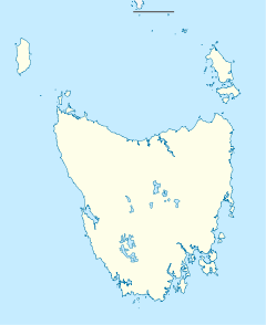
 Bruny Island (Tasmania)
Geography Location Australia Coordinates 43°22′S 147°17′E / 43.367°S 147.283°ECoordinates: 43°22′S 147°17′E / 43.367°S 147.283°E Area 362 km2 (139.8 sq mi)[1] Highest elevation 571 m (1,873 ft) Highest point Mount Mangana Country AustraliaState Tasmania LGA Kingborough Council Demographics Population 600 Density 1.6 /km2 (4.1 /sq mi) Additional information Official website www.brunyisland.org.au Bruny Island is an island off the south-eastern coast of Tasmania, from which it is separated by the D’Entrecasteaux Channel. Storm Bay is located to the island's northeast. Both the island and the channel are named after French explorer Bruni d'Entrecasteaux. Its traditional Aboriginal name was Alonnah Lunawanna, which survives as the name of two island settlements, Alonnah and Lunawanna.
Contents
Geography
 "The Neck" connects the two halves of Bruny Island and is an important breeding site for Short-tailed Shearwater and Fairy Penguins.
Geologically, Bruny Island is actually two land masses - North Bruny and South Bruny - that are joined by a long, narrow sandy isthmus. The holiday village of Dennes Point is located in North Bruny, while South Bruny is the site of the towns of Alonnah, Adventure Bay and Lunawanna.
Outside its settlements the island is covered in grazing fields and large tracts of dry eucalyptus forest. Inland forests continue to be logged, but other large sections - mostly along the southeastern coast - are preserved as the South Bruny National Park. While the seaward side of the island features two long beaches - Adventure Bay and Cloudy Bay - it is for the most part extremely rugged, with cliffs of dolerite that tower over 200 metres above sea level, and which are amongst the highest sea cliffs in Australia. Bruny's channel side is far more sheltered and a favourite fishing and recreational boating area for local and interstate visitors.
Access to the island is by vehicular ferry, funded by the State Government. Since 1954, four vessels have operated the Bruny Island Ferry service between the island and Kettering on the mainland. The service is currently plied by the Mirambeena, which is unusual for using a Voith-Schneider propulsion system rather than a conventional propeller.
The d'Entrecastaux Channel region, sheltered by Bruny Island, is increasingly subject to foreshore erosion, some areas have begun sandbagging to reduce the effects[2].
History
Bruny Island was originally inhabited by the Aborigines until European arrival, although there is still a large community of people who identify as Aboriginal. Abel Tasman tried to land in the vicinity of Adventure Bay in November 1642. In 1773 Tobias Furneaux discovered and named Adventure Bay; four years later on 26 January 1777 James Cook's two ships, the Resolution and Discovery stayed in the bay for two days. Cook carved his initials in a tree that was destroyed in a 1905 bushfire and is now commemorated by a plaque. In 1788 and again in 1792 William Bligh anchored in Adventure Bay. The island itself however is named after the French explorer Bruni d'Entrecasteaux who explored the Channel region in 1792. It was known as Bruni Island until 1918, when the spelling was changed to Bruny. Since then the island has become known as a holiday location with surfing beaches, National Parks and historical sites. In more recent history the Bruny Island was the site of a land transfer by the state Government to local Aboriginal people.[3]
Environment
Bruny Island is classified by BirdLife International as an Important Bird Area because it supports the world's largest population of the endangered Forty-spotted Pardalote, up to a third of the world population of the Swift Parrot, 13 of Tasmania's 14 endemic bird species, and up to 240,000 breeding pairs of the Short-tailed Shearwater (or Tasmanian Muttonbird).[4]
Tourism
 Black-faced Cormorants (Phalacrocorax fuscescens), Bruny Island, Tasmania
A key contributor to Bruny Island's economy is its growing tourism industry. Being home to the South Bruny National Park, tourism on the island centres around the showcase of its natural assets.[5][6]
The Cape Bruny Lighthouse (1838) is an iconic Australian lighthouse and was the oldest continuous lighthouse under operation by the Commonwealth. Now out of service, it has been transferred to the Tasmanian Government and is part of the South Bruny National Park.[7]
In 2010/11, overall visitors to Bruny Island increased 4% to 74,600.[8] The island is primarily a day-trip destination with only 21,800 visitors staying on the island overnight.[9] There are a growing number of tourism businesses on the island including a cheese factory, oyster farm, vineyard, smokehouse, lighthouse, museum, art gallery, two eco-cruises along with various accommodation properties and cafes.
Townships
 Rock formation off the coast of Bruny Island.
The main areas of Bruny Island include:
- Adventure Bay
- Alonnah
- Barnes Bay
- Cloudy Bay
- Dennes Point
- Fluted Cape
- Lunawanna
- Simpsons Bay
References
- ^ "Bruny Island". Britannica Online. http://original.britannica.com/eb/article-9016797/Bruny-Island. Retrieved 2008-08-17.
- ^ Flora Fox, Flora Fox, News and Information about Southern Tasmania 2011
- ^ Bruce Elder, "Rock of Ages", Sydney Morning Herald, 13 February 1999
- ^ "IBA: Bruny Island". Birdata. Birds Australia. http://www.birdata.com.au/iba.vm. Retrieved 2011-06-06.
- ^ "Statistics - Tasmania,2002". Australian Bureau of Statistics. http://www.abs.gov.au/AUSSTATS/ABS@.NSF/7d12b0f6763c78caca257061001cc588/84e04703e1a91a53ca256c3200241725!OpenDocument. Retrieved 2008-08-10.
- ^ "Tas Country Hour Feature Stories". ABC Rural Online. http://www.abc.net.au/rural/tas/features/gallery_bruny.htm. Retrieved 2008-08-10.
- ^ "Cape Bruny Lighthouse". Lighthouses of Tasmania. Lighthouses of Australia Inc. http://www.lighthouse.net.au/lights/TAS/Cape%20Bruny/Cape%20Bruny.htm. Retrieved 2007-11-08.
- ^ "Places Visited, Tasmanian Tourism Visitor Survey June 2011". Tourism Tasmania. http://webreporter.asteroid.com.au/webreporter/ttreports/?event=showPeriodicReport&styleName=PrComp&reportName=/TASMANIAN%20VISITOR%20SURVEY/7%20PLACES%20VISITED//Table%201d%20Places%20Visited%20on%20This%20Trip.xml&reportTitle=Table%201d%20Places%20Visited%20on%20This%20Trip&format=round-100. Retrieved 2011-11-12.
- ^ "Places Stayed Overnight, Tasmanian Tourism Visitor Survey June 2011". Tourism Tasmania. http://webreporter.asteroid.com.au/webreporter/ttreports/?event=showPeriodicReport&styleName=PrComp&reportName=/TASMANIAN%20VISITOR%20SURVEY/7%20PLACES%20VISITED//Table%201c%20Places%20Stayed%20Overnight.xml&reportTitle=Table%201c%20Places%20Stayed%20Overnight&format=round-100. Retrieved 2011-11-12.
External links
- Bruny Island at the Open Directory Project has links to Bruny Island businesses and information.
- Bruny Island travel guide from Wikitravel
Categories:- Islands of Tasmania
- Southern Tasmania
- Important Bird Areas of Australia
- Birdwatching


Wikimedia Foundation. 2010.