- Mount Dandenong, Victoria
-
For other uses of the name Dandenong, see Dandenong (disambiguation). For a different suburb with a similar name, see Dandenong, Victoria.
Mount Dandenong
Melbourne, Victoria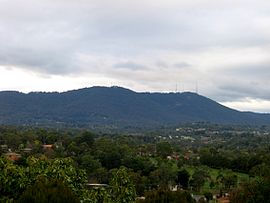
Mount Dandenong from MooroolbarkPopulation: 1276 (2006)[1] Established: 1893 Postcode: 3767 Coordinates: 37°49′52″S 145°21′36″E / 37.83111°S 145.36°ECoordinates: 37°49′52″S 145°21′36″E / 37.83111°S 145.36°E Area: 10.1 km² (3.9 sq mi) Location: 35 km (22 mi) from Melbourne LGA: Shire of Yarra Ranges State District: Monbulk Federal Division: Casey, La Trobe Localities around Mount Dandenong: Montrose Montrose Kalorama Kilsyth Mount Dandenong Olinda The Basin Sassafras Olinda Mount Dandenong is both a mountain and small township/suburb of Greater Melbourne, Victoria, Australia, 35 km east from Melbourne's central business district. Its Local Government Area is the Shire of Yarra Ranges. At the 2006 Census, Mount Dandenong had a population of 1,276.
The mountain, upon which the suburb is located, was originally known as Corhanwarrabul[2] and is 633 metres tall. The mountain lends its name to the entire range of which it is a part, the Dandenong Ranges.
Light to moderate Snow falls occur on Mount Dandenong a few times most years, mostly frequently between late winter and late spring. The area around Mount Dandenong experienced a highly unusual summer snow fall on Christmas Day 2006.[3]
Contents
History
Originally the town was to be named Mount Corhanwarrabul, but due to the problems that were foreseen with the spelling and pronunciation of this name, the Surveyor-General's office opted to name it Mount Dandenong. However, today there is still a Mount Corhanwarrabul, which is on the site of Burkes Lookout. The town of Mount Dandenong was settled in 1893, along with a neighbouring town, Olinda. It was around this time that the Government established 10-acre (40,000 m2) farms that would be used to harvest timber.
By around 1900 the town had its own general store and primary school. The Post Office, opened in 1902, was closed and replaced by one at Kalorama in 1991. In 1922 the first motorcars were seen in operation in Mount Dandenong.
In 1938, the 1938 Kyeema Crash occurred eighteen people were killed when the Kyeema, an Australian National Airways DC-2, VH-UYC crashed.
Around 2002 it was proposed that the word "Melbourne" be erected in large letters at the peak of the mountain in the style of the Hollywood sign, visible from the city centre. However this was met with outrage from local residents and was not pursued.
Climate
Climate data for Mount Dandenong Month Jan Feb Mar Apr May Jun Jul Aug Sep Oct Nov Dec Year Average high °C (°F) 22.1
(71.8)22.9
(73.2)19.7
(67.5)15.4
(59.7)11.7
(53.1)8.8
(47.8)8.2
(46.8)9.6
(49.3)11.6
(52.9)14.8
(58.6)17.3
(63.1)19.9
(67.8)15.2 Average low °C (°F) 11.5
(52.7)12.6
(54.7)11.3
(52.3)9.0
(48.2)6.9
(44.4)4.4
(39.9)3.6
(38.5)4.2
(39.6)5.0
(41.0)6.8
(44.2)8.3
(46.9)9.8
(49.6)7.8 Source: BOM[4] Recent Snowfalls
- 2007 - 17 and 18 July[5][6]
- 2006 - 25 December[3]
- 2006 - 15 November[7]
- 2006 - 28 October[8][9]
- 2005 - 10 August[10]
Features
At Mount Dandenong are include parks, forests, an arboretum, numerous lookout and many restaurants.
Lookout
 View of Melbourne from the summit at night
 View of Melbourne from the summit at dusk
Close to the summit of the mountain sits the SkyHigh Mount Dandenong restaurant, gardens and maze, re-opened in 2005.
On a clear day it is possible to see across the metropolitan area to the You Yangs and Mount Macedon, putting the Melbourne Central Business District and Port Phillip Bay into a broader geographical context.
The summit
 Transmission towers
The peak of the mountain, at 633 m above sea level, is also the site of the television and FM radio signal towers for the greater Melbourne area, which range in height from 72 m to 180 m. These towers are visible from quite a distance and distinguish Mount Dandenong from others in the Dandenong Ranges.
Tourist Road
Mount Dandenong Tourist Road, the main road going through Mount Dandenong, is host to many local shops. These include cafes, restaurants and eateries, pubs, day spas, wine and fine food purveyors, a nursery and many shops selling local crafts.[11]
William Rickets Sanctuary
Main article: William Ricketts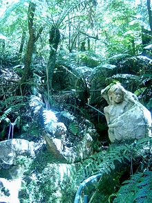 William Ricketts Sanctuary
The sanctuary is situated on the East face of Mount Dandenong. It is a unique park with over 93 ceramic sculptures woven into the eucalyptus forest.
References
- ^ Australian Bureau of Statistics (25 October 2007). "Mount Dandenong (State Suburb)". 2006 Census QuickStats. http://www.censusdata.abs.gov.au/ABSNavigation/prenav/LocationSearch?collection=Census&period=2006&areacode=SSC21475&producttype=QuickStats&breadcrumb=PL&action=401. Retrieved 2007-10-01.
- ^ Info sourced from Knox Historical Society - on place names in the area
- ^ a b Dowsley, Anthony (2006-12-26). "Melbourne shivers at Christmas". Herald Sun. http://www.news.com.au/heraldsun/story/0,21985,20974071-661,00.html. Retrieved 2006-12-28.
- ^ Environment Canada—Canadian Climate Normals 1971–2000, accessed 07 July 2009
- ^ Webb, Carolyn (2007-07-18). "Wet and white Victoria shivers through coldest day". theage.com.au. http://www.theage.com.au/news/national/wet-and-white-victoria-shivers-through-coldest-day/2007/07/17/1184559789294.html. Retrieved 2007-07-18.
- ^ Edmonds, Mike (2007-07-18). "Wintry blast to continue". Herald Sun. http://www.news.com.au/heraldsun/story/0,21985,22093199-2862,00.html. Retrieved 2007-07-18.
- ^ Wotherspoon, Sarah (2006-11-15). "Rain hits the target". Herald Sun. http://www.news.com.au/heraldsun/story/0,21985,20761277-661,00.html. Retrieved 2006-11-16.[dead link]
- ^ "Snow falls in south-east Aust as cold snap bites". ABC News Online. 2006-10-28. http://www.abc.net.au/news/newsitems/200610/s1775741.htm. Retrieved 2006-11-16.
- ^ Borensztain, Jordana (2006-10-29). "Snow, hail...but we're still in longest dry". Herald Sun. http://www.news.com.au/heraldsun/story/0,21985,20664065-661,00.html. Retrieved 2006-11-16.
- ^ http://www.bom.gov.au/announcements/media_releases/vic/20050810.shtml
- ^ http://www.about-australia.com/travel-guides/victoria/yarra-valley-dandenongs/attractions/in/mount-dandenong/
Badger Creek | Beenak | Belgrave | Belgrave Heights | Belgrave South | Big Pats Creek | Cambarville | Chirnside Park | Chum Creek | Coldstream | Dixons Creek | Don Valley | Fernshaw | Ferny Creek | Ferntree Gully | Gilderoy | Gladysdale | Gruyere | Healesville | Hoddles Creek | Kallista | Kalorama | Kilsyth | Launching Place | Lilydale | Macclesfield | McMahons Creek | Matlock | Menzies Creek | Millgrove | Monbulk | Montrose | Mooroolbark | Mount Dandenong | Mount Evelyn | Mount Toolebewong | Narre Warren East | Olinda | Powelltown | Reefton | Sassafras | Selby | Seville | Seville East | Sherbrooke | Silvan | Steels Creek | Tarrawarra | Tecoma | The Patch | Three Bridges | Toorongo | Tremont | Upper Ferntree Gully | Upwey | Wandin East | Wandin North | Warburton | Warburton East | Wesburn | Woori Yallock | Yarra Glen | Yarra Junction | Yellingbo | Yering
Categories:- Towns in Victoria (Australia)


Wikimedia Foundation. 2010.