- New York State Route 313
-
NYS Route 313
Route information Maintained by NYSDOT Length: 8.96 mi[2] (14.42 km) Existed: 1930[1] – present Major junctions West end:  NY 22 in Cambridge
East end:  VT 313 at Salem
Location Counties: Washington Highway system Numbered highways in New York
Interstate • U.S. • N.Y. (former) • Reference • County←  NY 312
NY 314  →
→New York State Route 313 (NY 313) is a state highway in New York State. It begins at NY 22 in Cambridge, and intersects with two county routes on its journey from Cambridge to the state line in Salem. Once in Salem, the route crosses the Vermont border, entering the town of Arlington. It is located entirely within Washington County.
Contents
Route description
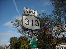
 NY 313's eastern terminus at an intersection with NY 22
Route 313 begins at an intersection with NY 22 in the southern region of Cambridge. The route heads to the northeast, intersecting with County Route 67 (East Main Street),[3] heading away from the village limits. Passing to the north of White Creek, Route 313 crosses out of the village and winds around a mountain base. At the intersection with Bowen Hill Road, a connector to the nearby Peaked Rock, the highway enters the hamlet of The Plains. After The Plains, Route 313 then heads through rural regions, passing to the south of Batten Kill. The kill follows Route 313 for some time. After passing through Murray Hollow, the highway intersects with the eastern terminus of County Route 61 (Shushan Buffums Road). Route 313 turns to the northeast, crossing the Batten Kill, which then parallels to the southeast. Running along the base of Dugway Mountain, Route 313 crosses the border and continues as Vermont Route 313.[4]
History
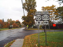
 NY 313's beginning at NY 22
NY 313 was assigned to its current alignment as part of the 1930 renumbering of state highways in New York. There was initially no matching route on the Vermont side of the highway;[1] however, the Vermont continuation was designated as VT 123 ca. 1934.[5][6]
Major intersections
The entire route is in Washington County.
Location Mile[2] Destinations Notes Village of Cambridge 0.00 NY 22Town of Salem 8.96 VT 313Continuation into Vermont 1.000 mi = 1.609 km; 1.000 km = 0.621 mi References
- ^ a b Standard Oil Company of New York (1930). Road Map of New York (Map). Cartography by General Drafting.
- ^ a b "2008 Traffic Volume Report for New York State" (PDF). New York State Department of Transportation. June 16, 2009. p. 212. https://www.nysdot.gov/divisions/engineering/technical-services/hds-respository/NYSDOT%20TVR%202008%20by%20Route.pdf. Retrieved February 1, 2010.
- ^ Perry, N.W. (2003). "County Roads in New York State (Washington County)". Empire State Roads. http://www.empirestateroads.com/cr/crwashington.html. Retrieved January 3, 2010.
- ^ Google, Inc. Google Maps – overview map of NY 313 (Map). Cartography by Google, Inc. http://maps.google.com/maps?q=from%3A%20RT-22%20%26%20Gilbert%20St%2C%20Cambridge%2C%20Washington%2C%20New%20York%2012816%2C%20United%20States%20to%3AVT%20Route%20313%20W%20%26%20RT-313%2C%20United%20States&ie=UTF-8&oe=utf-8&rls=org.mozilla:en-US:official&client=firefox-a&um=1&sa=N&tab=wl. Retrieved October 26, 2008.
- ^ Texas Oil Company (1933). Texaco Road Map – New York (Map). Cartography by Rand McNally and Company.
- ^ Texas Oil Company (1934). Road Map of New York (Map). Cartography by Rand McNally and Company.
External links
Categories:- State highways in New York
- Transportation in Washington County, New York


Wikimedia Foundation. 2010.