- Dandenong, Victoria
-
This article is about the Melbourne suburb. The name may also refer to the City of Greater Dandenong (the Local Government Area within which Dandenong is situated) or the similarly named suburb of Mount Dandenong, Victoria. For all other uses, see Dandenong (disambiguation).
Dandenong
Melbourne, Victoria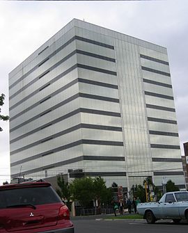
The Australian Taxation Office office building in Dandenong CBD
 Dandenong
Population: 16,729 (2006 census)[1] Established: 1837 Postcode: 3175 Area: 8.9 km² (3.4 sq mi) Location: 30 km (19 mi) from Melbourne LGA: City of Greater Dandenong State District: Dandenong Federal Division: Bruce, Isaacs Suburbs around Dandenong: Noble Park North Dandenong North Endeavour Hills Noble Park Dandenong Doveton Keysborough Dandenong South Doveton Dandenong is a suburb and major urban centre in metropolitan Melbourne, Victoria, Australia, 30 km south-east from Melbourne's central business district. Situated on Dandenong Creek and mostly flat land at the foothills of Mount Dandenong, it is the main administrative centre for the City of Greater Dandenong Local Government Area (LGA). At the 2006 Census, central Dandenong had a population of 16,729 while the City of Greater Dandenong has an estimated population of 137,600.
It began as a township in 1852 and at the turn of the century was an important regional city with its own suburbs. During the mid 20th century it became a major metropolitan manufacturing and commercial area and conurbation of Greater Melbourne. A Business district, the former town centre, covers much of its area and is one of the largest in Greater Melbourne.
Dandenong is the hub of one of metropolitan Melbourne's most culturally diverse areas, with approximately 55.5% of Greater Dandenong residents born overseas[1] from 156 different birthplaces and 51% from non-English speaking backgrounds. Significant ethnic groups include immigrants from India, Sri Lanka and Afghanistan.[1]
It is currently undergoing major transit oriented urban renewal which was first planned in the Melbourne 2030 strategy.
Contents
History
Toponomy and prehistory
Prior to the European settlement of Australia, the flat to undulating land was densely forested with red gum and was inhabited by the Woiwurrung Indigenous Australian tribe.
The name is generally thought to be derived from the Woiwurrung word "Tanjenong" meaning "lofty mountains" possibly referring to the nearby Dandenong ranges.[2][3]
Another popular theory that the name comes from 'bad flour', or 'no good damper'. A local tale revolves around local aboriginals finding/stealing a bag of lime and mistakenly using it to make damper. An old local hotel was the 'No Good Damper Inn'.[4]
A third version has the name Dandenong coming from 'a burning' and 'the past' reflecting bushfires on the Dandenongs.[5]
European settlement
Joseph Hawdon established a pastoral run on Narra Narrawong in 1837, bringing cattle from Sydney by land. Soon a few timber cutters and a police camp were also located there. Dandenong Post Office opened on 1 July 1848.[6]
By 1850, the whole area had been taken up for grazing. Dandenong Creek was first bridged in 1840. A road was made from Melbourne, making Dandenong, by the late 1850s, an important staging post for travellers into Gippsland. It became known as the 'gateway to Gippsland'. A township was surveyed in 1852. Milling of the red gum timber became an important industry, and charcoal burning, tanning, quarrying and brick making also flourished. A livestock market was established in 1866.[7]
The Western Port Aboriginal Protectorate Station was located north-east of Dandenong from 1840 to 1844. This area had been an important meeting and ceremonial site for Aboriginal tribes. The Native Police Corps established its headquarters there until its disbandment in 1852. The Police Paddocks were then used for breeding and resting police horses.
By 1861, there were 40 houses in the township housing 193 people. Dandenong Shire was proclaimed in 1873. The Australian Handbook records the progress of the town by 1875.
 A view of the Dandenong Post Office at the turn of the century (now demolished). The back of the town hall on the right
The Dandenong Town Hall, Lonsdale Street, was built in Free Classical style in 1890 as the combined Shire Hall, Courthouse and Mechanics Institute, at a cost of about 12,000 pounds. The architects were Beswicke and Hutchins and the contractor McCullogh and McApline. The two storey, stucco rendered brick building, on a bluestone base course, features a lofty, Mansard-roofed, corner clock tower and projecting end wings with serlian motif windows and capped by pedimented niches.[8]
Postwar era
 Lonsdale Street from Dandenong Town Hall tower in 1938
The post-war industrial boom brought an influx of European migrants, particularly from Italy and Greece. This caused the creation of several suburbs of Dandenong including the public housing estate of Doveton.
In the 1950s, Melbourne rapidly expanded south east along the freeway and Dandenong railway line to Dandenong and beyond and it became major metropolitan manufacturing and commercial area as industry extended into the outer suburbs. By the late 1960s, it was officially a suburban area of Melbourne and central Dandenong was transformed by modern buildings, with the redevelopment of the post office to a two storey modern building in 1960 followed by a three storey office development for AMP in 1966 and Dandenong Railway Station in 1975.[9]
Urban renewal
 Dandenong Plaza, Walker Street entrance
Development in Dandenong had stagnated since the opening of the Dandenong Plaza shopping centre which resulted in the closure of many shops in the central business district. Under the Melbourne 2030 policy, Dandenong was classified as a major activity centre[10] due to its central location with regard to its access to transport. These projects can be considered to be transit-oriented development, where population density is intended to be higher compared to other areas with poorer access to transport.
The Greater Dandenong city council has started a programme called Revitalising Central Dandenong, with $290 million proposed to be spent on various projects such as infrastructure upgrades, improved street frontages and public art in order to improve the general amenity of the Dandenong CBD.[11] In the longer term, the council wishes to transform Dandenong into a more pedestrian oriented and mixed-use centre.[12] This contrasts with the current situation where the CBD area is primarily occupied by offices and carparking, with a small amount of retail.
Dandenong's redevelopment is being overseen by the City of Greater Dandenong council and VicUrban, a Victorian Government agency responsible for urban planning. The project is a long-term project, expected to continue for 15 to 20 years.[13]
Current developments
Metro 2033
Metro 2033 is a major development located on the site of the former Dandenong Livestock Market. Established in 1866, the market was closed in 1998 and relocated to Gippsland because Dandenong had for many years been incorporated as a part of the Greater Melbourne area as a result of urban sprawl. This left a large unused site situated across the railway lines from the CBD. In November 2005, VicUrban launched a project to develop the land into a mixed-use development consisting of 1100 residences as well as cafes and restaurants, known as Metro 3175, with 3175 signifying Dandenong's postcode.[14]
Because the site is isolated from the rest of the central Dandenong area, George Street was widened and extended with a bridge across the railway lines to improve access between the precincts. The bridge provides access for cars, pedestrians and cyclists and improves connections to bus services in the area.[15] Additionally, Cheltenham Road, a major east-west arterial has been realigned in order to remove traffic from nearby streets and encourage pedestrian use.[16]
When completed, the Metro 2033 project is expected to have a total population of about 3000.
Drum Theatre
 Former Town Hall
Designed by Williams Ross Architects, the Drum Theatre is a redevelopment of the Dandenong Town Hall, built in 1880. The town hall was redeveloped into a performing arts centre with a 525 seat proscenium theatre. At the cost of $13 million, the project commenced construction in 2004 and was opened by Victorian Premier Steve Bracks on 11 February 2006.[17][18]
The redevelopment involved renovating the existing town hall building and the construction of a modern drum-shaped building. Its striking red colour is prominently visible from nearby streets in the CBD. There was some controversy over fears the redevelopment would destroy the historic facade of the town hall building, but this proved unfounded.
Dandenong High School redevelopment
The regeneration and redevelopment of the Dandenong High School is part of the uplifting of Dandenong. The school, which is the amalgamation of Dandenong High School and Cleeland and Doveton Secondary Colleges, will have 2100 students.
Transport
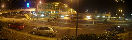 A panorama of the Dandenong railway station
Dandenong is primarily a private vehicle dependent community due to poorer public transport compared to suburbs closer to the CBD. It is served by the Monash Freeway as well as several other major arterial roads. Eastlink also passes near the suburb.
Dandenong railway station is approximately 50 minutes from Melbourne by train, and is situated adjacent to the CBD and is an interchange station for the Pakenham and Cranbourne lines as well as regional trains on the Gippsland railway line. The state government has proposed triplication of the railway line to support a higher volume of trains for the growing population in and around Dandenong as well as other suburbs and towns along the line.
The station also serves as a transport hub for the bus network, with almost all bus routes in the area passing through Dandenong station and an interchange on Thomas Street in the CBD. Most buses in the area are operated by Grenda's Bus Services whose depot is located near the railway station.
Cycling is facilitated via the Dandenong Creek Trail, part of the off-road cycling network which connects the city trails to nearby Jells Park.
In a council planning policy document, Light rail is suggested as a future transport mode for the central Dandenong area.[19]
Education
Three state high schools – Lyndale Secondary College and two campuses of Dandenong High School (Dandenong and Cleeland) – and one Catholic high school (St John's Regional College), as well as numerous state and two Catholic primary schools, are located within the suburb's boundaries. Dandenong also contains Emerson School, a specialist school for those with mild intellectual disabilities from a catchment area extending as far north as Rowville.
Sport
The suburb has several Australian Rules football teams, one is the Dandenong Redlegs (formerly Dandenong Demons/Dandenong West), competing in the Southern Football League at the Dandenong Showgrounds.[20] Other teams in the Dandenong Area include the Dandenong Stingrays (Under 18 TAC Cup - Elite Junior) at Shepley Oval, St John's Old Collegians (VAFA and VWFL - Senior) at Carroll Reserve, and the Dandenong Saints (DDJFL - Junior) at Carroll Reserve.
Dandenong hosts two teams in football (soccer). Dandenong Thunder plays in the Victorian Premier League which is the second tier behind the A-League and enjoys much support from the local community. The side plays their home fixtures at George Andrews Reserve has been both premiers and champions of Victoria multiple times.[21] The other team is Dandenong City Soccer Club who have hosted many international players in its time. These include players such as Ljubo Miličević, Eugene Galeković & Ante Milicic. The side plays at the Frank Holohan Soccer Complex and is rivals with Dandenong Thunder.
Dandenong also has numerous cricket clubs in the area. Dandenong Cricket Club plays in the Victorian Premier League and has produced a number of state players to date. The most important of these has been Peter Siddle (Australia), Darren Pattinson (England) and Cameron White (Australia) who have all gone on to play test cricket. Other prominent players from the club include Ian Harvey, James Pattinson, Brett Forsyth, Jackson Coleman and Kumar Sana. The area also consists of a women's team, the Dandenong Women's Cricket Club who compete in the Victorian Women's Cricket Association. Several other clubs in the area play in the Dandenong and District Cricket Association (DDCA). These include Buckley Ridges, Dandenong North, Dandenong West, and the St Mary's Cricket Clubs. Other clubs within the City of Greater Dandenong include Coomoora, Keysborough, Lyndale, Parkfield, Silverton, Southern Pirates, Springvale and Springvale South Cricket Clubs. Noble Park Cricket Club is also located within the City of Greater Dandenong, and plays in the Victorian Sub-District Cricket Association.
Golfers play at the course of the Forest Hills Golf Club on Wedge Street, Dandenong.[22]
Dandenong Stadium
The Dandenong stadium is the home of the Dandenong Rangers (an Australian Women's Basketball League team) and Victoria's state volleyball competition, and from 7 to 12 July played host to the 2008 Australian Junior Volleyball Championships.
Sister cities
See also
- City of Dandenong - the former local government area of the same name.
- Electoral district of Dandenong
References
- ^ a b c Australian Bureau of Statistics (25 October 2007). "Dandenong (State Suburb)". 2006 Census QuickStats. http://www.censusdata.abs.gov.au/ABSNavigation/prenav/LocationSearch?collection=Census&period=2006&areacode=SSC21213&producttype=QuickStats&breadcrumb=PL&action=401. Retrieved 2007-09-01.
- ^ http://www.cclc.vic.gov.au/history/topics/placenames.html#D
- ^ http://www.greaterdandenong.com/Documents.asp?ID=5898&Title=Greater+Dandenong's+History
- ^ "4.0 What's In A Name?". http://www.parkweb.vic.gov.au/education/pdf/crp_name.PDF. Retrieved 2007-08-24.
- ^ "RLHP Local Stories: Name Origins of Places In Rowville and Lysterfield". http://www.rlcnews.org.au/stories/european_settlement/name_origins_of_places_in_rowville_and_lysterfield.php. Retrieved 2007-08-24.
- ^ Premier Postal History. "Post Office List". https://www.premierpostal.com/cgi-bin/wsProd.sh/Viewpocdwrapper.p?SortBy=VIC&country=. Retrieved 2008-04-11.
- ^ "Dandenong History". http://www.greaterdandenong.com/Documents.asp?ID=73&Title=Dandenong+History&Type=d. Retrieved 2007-01-09.
- ^ "Town Hall, Dandenong, VIC Profile:". http://www.aussieheritage.com.au/listings/vic/Dandenong/TownHall/19047. Retrieved 2007-03-19.
- ^ Vincent Adams Winter (1990). VR and VicRail: 1962 - 1983. p. 106. ISBN 0 9582069 3 3.
- ^ Department of Sustainability and Environment (November 2003). "Addendum to Melbourne 2030 Activity Centres and Principal Public Transport Network Plan" (pdf). p. 4. http://www.dse.vic.gov.au/melbourne2030online/content/implementation_plans/Addendum.pdf#page=4. Retrieved 2007-01-09.
- ^ City of Greater Dandenong. "Revitalisation Projects". http://www.greaterdandenong.com/Documents.asp?ID=6263&Title=Revitalisation+Projects&Type=d. Retrieved 2007-01-08.
- ^ City of Greater Dandenong. "Destination Dandenong" (pdf). p. 10. Archived from the original on 2006-08-29. http://web.archive.org/web/20060829142432/http://greaterdandenong.com/SiteDocuments/1004_DestDand.pdf#page=10. Retrieved 2007-01-08.
- ^ VicUrban. "Who's Involved?". Revitalising Dandenong. http://revitalisingdandenong.com/dandenong/whos/whos.htm. Retrieved 2007-01-08.
- ^ City of Greater Dandenong. "Metro 3175". http://www.greaterdandenong.com/Documents.asp?ID=2485&Title=Metro+3175. Retrieved 2007-01-08.
- ^ VicUrban. "George Street Bridge". Revitalising Dandenong. http://revitalisingdandenong.com/dandenong/plan/geor.htm. Retrieved 2006-01-09.
- ^ "Revitalising Central Dandenong: A Shared Vision". 2006-04-26. p. 6. http://www.revitalisingdandenong.com/dandenong/downloads/RCD_shared_vision.pdf?page=9. Retrieved 2007-01-09.
- ^ City of Greater Dandenong. "Town Hall Redevelopment". http://www.greaterdandenong.com/Documents.asp?ID=1438&Title=Town+Hall+Redevelopment&Type=d. Retrieved 2007-01-09.
- ^ Williams Ross Architects. "Dandenong Performing Arts Centre". Archived from the original on 2007-09-16. http://web.archive.org/web/20070916123722/http://www.williamsross.com.au/html/s02_article/article_view.asp?id=158&nav_cat_id=129&nav_top_id=55&dsb=44. Retrieved 2007-01-09.
- ^ http://www.dse.vic.gov.au/planningschemes/greaterdandenong/ordinance/22_lpp07_gdan.pdf
- ^ Full Point Footy. "Dandenong Demons". http://www.fullpointsfooty.net/dandenong_demons.htm. Retrieved 2008-10-21.
- ^ http://www.footballfedvic.com.au/
- ^ Golf Select. "Forest Hills". http://www.golfselect.com.au/armchair/courseView.aspx?course_id=659. Retrieved 2009-05-11.
External links
- History of Dandenong
- Dandenong Theatre Company
- Windmill Theatre Company
- Revitalising Central Dandenong
- City of Greater Dandenong - Major Developments
- Australian Places - Dandenong
- What's In A Name?
- RLHP Local Stories: Name Origins of Places In Rowville and Lysterfield
Coordinates: 37°59′10″S 145°12′47″E / 37.986°S 145.213°E
Suburbs of the City of Greater Dandenong | Melbourne | Victoria Bangholme · Dandenong · Dandenong North · Dandenong South · Keysborough · Lyndhurst · Noble Park · Noble Park North · Springvale · Springvale South
Cities of Victoria, Australia Regional VictoriaArarat · Bairnsdale · Ballarat · Benalla · Bendigo · Castlemaine · Colac · Echuca · Geelong · Hamilton · Horsham · Maryborough · Mildura · Moe · Morwell · Portland · Sale · Shepparton · Swan Hill · Traralgon · Wangaratta · Warrnambool · WodongaCategories:- Suburbs of Melbourne


Wikimedia Foundation. 2010.