- Chernigov Governorate
-
Черниговская губернiя
Chernigov GovernorateGovernorate of Russian Empire ← 
1802–1925 →
 →An old map showing the Chernigov Governorate.
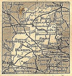
Capital Chernigov History - Established February 27 1802 - Disestablished August 01 1925 Area - (1897) 52,396 km2 (20,230 sq mi) Population - (1897) 2,298,000 Density 43.9 /km2 (113.6 /sq mi) Political subdivisions uezds: 15 (1795-1919)
11 (1919-1923)
okrugs: 5 (1923-1925)Chernigov Governorate (English)
Черниговская губернiя (Pre-1918 Russian)
Чернігівська губернія (Ukrainian)300px
Chernigov GovernorateCoat of Arms 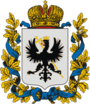
Established 1802 Abolished 1923 Political status
RegionGovernorate
European RussiaArea Area
- Rank46,042.3 verst²
n/aPopulation (1897 census) Population
- Rank
- Density
- Urban
- Rural2,297,854 inhabitants
n/a
49.9 inhab. / verst²
n/a
n/aGovernment Governor
Last Headn/a
n/aThe Chernigov Governorate (Russian: Черниговская губернiя; translit.: Chernigovskaya guberniya), also known as the Government of Chernigov, was a guberniya in the historical Left-bank Ukraine region of the Russian Empire, which was officially created in 1802 from the disbanded Malorossiya Governorate with an administrative centre of Chernigov (modern Chernihiv). Its modern borders are roughly consistent of the modern Chernihiv Oblast, but also included a large section of Sumy Oblast and smaller sections of the Kiev Oblast of Ukraine, in addition to most of the Bryansk Oblast, Russia.
Contents
Administrative division
 The coat of arms of the Chernigov Governorate.
The governorate consisted of 15 uyezds:
- Borzna - Борзна,
- Glukhov - Глухов,
- Gorodnya - Городня,
- Kozelets - Козелец,
- Konotop - Конотоп,
- Krolevets - Кролевец,
- Nezhin- Нѣжинъ,
- Novgorod-Seversky - Новгород-Северский,
- Oster - Остёр,
- Sosnitsa - Сосница,
- Chernigov - Чернигов,
- Mglin - Мглин,
- Novozybkov - Новозыбков,
- Starodub - Стародуб,
- Surazh - Сураж.
The Chernigov Governorate covered a total area of 52,396 km², and had a population of 2,298,000, according to the 1897 Russian Empire census. In 1914, the population was 2,340,000. After the formation of the Ukrainian SSR the territory was partitioned along ethnic borders with the four northern uyezds with mostly Belorussian and Russian population (Mglin, Novozybkov, Starodub, Surazh) were transferred to the newly formed Gomel Governorate (then part of the RSFSR), and in 1926 - to the Bryansk Governorate.
On March 7, 1923 the territory of Chernigov Governorate was reorganized into five okrug:
- Konotop
- Nizhyn
- Novhorod-Siversky
- Snovsk (liquidated on June 10, 1925)
- Chernihiv
Principal cities
- Russian Census of 1897
- Nezhin - 32,113 (Ukrainian - 21,733, Jewish - 7,578, Russian - 2,366)
- Chernigov - 27,716 (Ukrainian - 10,085, Jewish - 8,780, Russian - 7,985)
- Konotop - 18,770 (Ukrainian - 10,290, Jewish - 4,415, Russian - 3,565)
- Novozybkov - 15,362 (Russian - 11,055, Jewish - 3,787, Belorussian - 303)
- Glukhov - 14,828 (Ukrainian - 8,621, Jewish - 3,837, Russian - 2,217)
- Borzna - 12,526 (Ukrainian - 10,846, Jewish - 1,515, Russian - 109)
- Starodub - 12,381 (Russian - 7,255, Jewish - 4,897, Ukrainian - 133)
- Krolevets - 10,384 (Ukrainian - 8,328, Jewish - 1,815, Russian - 209)
- Berezna - 9,922 (Ukrainian - 8,349, Jewish - 1,354, Russian - 144)
- Novgorod-Seversky - 9,182 (Ukrainian - 4,884, Jewish - 2,941, Russian - 1,296)
- Mglin - 7,640 (Russian - 4,840, Jewish - 2,675, Belorussian - 75)
- Sosnitsa - 7,087 (Ukrainian - 5,068, Jewish - 1,840, Russian - 158)
- Korop - 6,262 (Ukrainian - 5,309, Jewish - 865, Russian - 77)
- Oster - 5,370 (Ukrainian - 3,229, Jewish - 1,596, Russian - 399)
- Kozelets - 5,141 (Ukrainian - 2,834, Jewish - 1,632, Russian - 468)
- Pogar - 4,965 (Russian - 3,800, Jewish - 1,159, Germans - 6)
- Gorodnya - 4,310 (Ukrainian - 2,349, Jewish - 1,248, Russian - 604)
- Surazh - 4,006 (Jewish - 2,400, Belorussian - 978, Russian - 559)
- Novoye Mesto - 1,488 (Russian - 1,421, Jewish - 67)
Language
- By the Imperial census of 1897[1]. In bold are languages spoken by more people than the state language.
Language Number percentage (%) males females Ukrainian 1,526,072 66.41 747,721 778,351 Russian 495,963 21.58 236,842 259,121 Belarusian 151,465 6.59 73,691 77,774 Yiddish 113,787 4.95 54,724 59,063 German 5,306 0.23 2,664 2,642 Polish 3,302 0.14 1,775 1,527 Persons
that didn't name
their native language74 >0.01 32 42 Other[2] 1,885 >0.01 1,247 638 Total 2,297,854 100 1,118,696 1,179,158 See also
- List of governors of Chernigov Governorate
References and notes
- ^ Language Statistics of 1897 (Russian)
- ^ Languages, number of speakers which in all gubernia were less than 1000
Ukrainian historical regions Kievan Rus' Principalities Medieval epoch Red Ruthenia · Galicia–Volhynia · Bełz Voivodeship · Bracław Voivodeship · Czernihów Voivodeship · Kijów Voivodeship · Podole Voivodeship · Ruthenian VoivodeshipCossack epoch Cossack Hetmanate · Right-bank Ukraine · Left-bank Ukraine · Sloboda Ukraine · Zaporozhian Sich · Dnieper Ukraine · Little RussiaRussian Imperial guberniyas Austro-Hungarian provinces 20th century Ukrainian SSR · Moldavian ASSR · Drohobych Oblast · Izmail Oblast · Crimean Oblast · Lviv Voivodeship · Ternopil Voivodeship · Volhynian Voivodeship · Stanyslaviv Voivodeship · Carpatho-Ukraine · Reichskommissariat Ukraine · Distrikt GalizienGeographical Nadbuzhia · Budzhak · Black Sea Ukraine · Donbas · Dniester Ukraine · Podolia · Pokuttya · Pryazovya · New Russia · Polissya · Podniprovya · Porossia · Prydunavya · Prykarpattia · Porizhia Ukraine · Volhynia · ArtaniyaEthno-Ukrainian regions abroad External links
- whp - Information
- Chernigov Guberniya - Article in Brockhaus and Efron Encyclopedic Dictionary (Russian)
- Chernigov Governorate - Historical coat of arms (Ukrainian)/(English)
- Chernihiv gubernia - Article in the Encyclopedia of Ukraine
Categories:- States and territories established in 1802
- States and territories disestablished in 1925
- Governorates of the Russian Empire
- History of Ukraine
- Historical regions in Ukraine


Wikimedia Foundation. 2010.