- Northcote, Victoria
-
Northcote
Melbourne, Victoria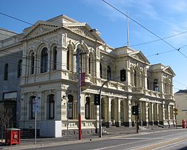
Northcote Town Hall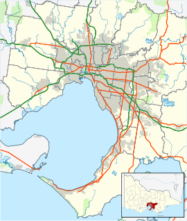
 Northcote
Population: 22,061 (2006)[1] Postcode: 3070 Area: 6.3 km² (2.4 sq mi) Location: 7 km (4 mi) from Melbourne LGA: City of Darebin State District: Northcote Federal Division: Batman Suburbs around Northcote: Brunswick East Thornbury Thornbury Brunswick East Northcote Fairfield Fitzroy North Clifton Hill Fairfield Northcote
 pronunciation (help·info) is a suburb in Melbourne, Victoria, Australia, 7 km north-east from Melbourne's central business district. Its Local Government Area is the City of Darebin. At the 2006 Census, Northcote had a population of 22,061.
The name Northcote is thought to be derived from the leader of the English Conservative Party, Stafford Henry Northcote.
Northcote includes the distinct locality of Westgarth.
Contents
History
 Melbourne in 1888
The area now known as Northcote is on the traditional lands of the Wurundjeri people. According to the Darebin Historical Encyclopedia,[2] "[w]hite settlers knew the Wurundjeri as the ‘Yarra’ tribe. They were closely associated with the Yarra River and its subsidiaries, with various subgroups of the tribe owning lands at various spots on the course of the Yarra. They were the main tribe of Aboriginal people settled in the area that would become Melbourne. Their language, Woiwurrung, also distinguished them".
The subgroups of the Wurundjeri included the ‘true’ Wurundjeri, under the clan head Jakka-Jakka. This name is also spelt as Jaga-Jaga and Jika-Jika. His was one of the signatures on John Batman’s ‘treaty’ of 1835. This clan occupied land which included parts of the Darebin Creek. The Kurnaje-berreing were further divided into two groups. Billibellary led one group, the Wurundjeri-willam; his clan’s lands included the Merri Creek and much of what is now Darebin. The other was led by Bebe-jan. His clan owned some of the land by the Darebin Creek. The final subgroup of the Wurundjeri was called the Boi-berrit, led by Bungerim. Their land was centred around Sunbury. Within these subgroups there was further division, usually on family lines, with each group owning a defined tract of land.
Under leaders like Billibellary, the Wurundjeri were able to develop reasonable working relationships with white settlers. While they remained true to their values and customs, they also became guides, messengers and workers in a world that was changing so dramatically around them. Due to the tolerance and wisdom of Aboriginal leaders like Billibellary and Beruke, and the patience and determination of Assistant Protector William Thomas, there was little violence between whites and the Wurundjeri-willam, a marked contrast to the violence and brutality that disgraces much of the early history of white settlement in Australia".
The European settlement of the Northcote area began in 1839 with a Government land sale. Many of these allotments were long, narrow strips of land running in an east-west configuration, which has resulted in the street patterns of the suburb to this day. The area to the north of (what is now) Oldis Gardens was surveyed as the township of Northcote in 1853. The name is thought to be derived from the leader of the English Conservative Party, Stafford Henry Northcote. Although he was never Prime Minister he held several important cabinet posts.
The southerly surveyed portion is now Westgarth. It was the area further north of present-day Westgarth which saw settlement and development, particularly around the mansion built by William Rucker on Bayview St in 1842 (the area now known as Ruckers Hill). Large, expensive houses were built throughout the Victorian gold rush of the 1850s. Lower Plenty Road (or High Street as it is known today) became the central street of Northcote, instead of Westgarth Street as initially proposed. A bridge was built across the Merri Creek in 1858, making access to the area more convenient. Throughout the 1850s, churches, schools, and hotels were built (see Timeline).
Throughout the 1870s the area contained a number of slaughteryards, piggeries, and claypits. One such claypit operated on the corner of Separation Street and High Street, which eventually became the Northcote Patent Brick Company, supplying much of the area's bricks. When the brickworks closed down, the site became the Northcote Plaza Shopping Centre in 1981. The quarried land became the Northcote Regional Tip, later to be transformed into All Nations Park, a public park. The Northcote Primary School on Helen Street opened in 1874. At this stage, Northcote was still a rural area, with orchards and occasional mansions.
Throughout the 1880s, land in Northcote was relatively cheap, owing to its lack of public transport. This attracted speculative property investors, as well as people of limited financial means, setting in place Northcote's reputation as a working-class suburb. Following the arrival of public transport in the late 1880s and early 1890s, the population of Northcote began to increase. More businesses opened along High Street, as well as churches and schools. The Little Sisters Of The Poor began building on a site along St Georges Road, which still exists today. The town hall was built in 1890, the same year the borough of Northcote was proclaimed. The Northcote Football Club was established in 1898, with its home ground at Northcote Park.
The Northcote Picture Theatre opened in 1912, presently its building is one of the oldest surviving picture theatres in Victoria (it is now used as a reception center). A free library opened in 1911, financed by Scottish philanthropist Andrew Carnegie. Throughout the 1920s development grew along St Georges Road. The Northcote High School opened in 1926.
Throughout the 1950s the area became home to a large number of Italian and Greek migrants. By the 1980s, gentrification of Fitzroy and Fitzroy North had pushed some of the artistic and activist communities north into Northcote.
Public transport
Access to Northcote via public transport was initially via the Inner Circle Line, which when linked to the Heidelberg Line in 1888, ran close to the southern border of the suburb. The line to Whittlesea was opened in 1891, creating a direct line to Northcote, although the line initially journeyed via Royal Park, Carlton North, and Fitzroy North, before a line was built from Clifton Hill to Melbourne through the suburb of Richmond in 1901 to 1903. The northern section of the Inner Circle Line was closed to passengers in 1948, leaving the eastern section (from Melbourne to Clifton Hill, via Richmond and Collingwood).
Presently, Northcote has five railway stations along two lines. The Epping Line serves Merri Station (formerly known as Northcote Station), Northcote Station (formerly known as Middle Northcote Station), and Croxton Station. The Hurstbridge Line serves Westgarth Station (formerly known as Westgarth Street Station), and Dennis Station.
A cable tram began operations along High Street in 1890 (now tram route 86). A tram line opened along St. Georges Road in 1920 (now tram route 112). Northcote is also served by bus routes along Separation Street, Westgarth Street, and Victoria Road.
The present
Westgarth, to the south of Northcote proper, is the more gentrified area of Northcote, populated with cafes, bars, small fashion boutiques, and restaurants.
High Street north of Ruckers Hill is an area currently in flux. With its mix of ethnic and working class communities, it is home to numerous furniture outlets, reception centres, the Northcote Plaza Shopping Centre, factories and warehouses - as well as several vacant shop fronts. Recently the influx of numerous cafes, bars and art galleries has added to its eclectic nature, and this, combined with rising property prices, is changing the nature of the suburb. In July 2005, Darebin Council is beginning an extensive community consultation process leading to the formulation of a new Structure Plan for Northcote, known as the Northcote Place Making Project.
Currently, Northcote has a residual population of first and second generation Greek and Italian migrants, and a (declining) population of students. Northcote also has one of Melbourne's largest Lesbian communities.
Public space
All Nations Park
All Nations Park is located adjacent to the Northcote Plaza Shopping Centre (which itself opened in October 1981 at the site of the old brickworks).
There is a large hill where the tip fills the hole where the quarry was.[clarification needed] There are skating facilities, as well as basketball courts, play equipment and picnic facilities. There is a lot of open space which many people use to fly kites and exercise their dogs. There is also a large native garden giving special attention to plants indigenous to the area, and a series of ponds.
The park was also the location of a December 2008 shooting involving police and a 15-year-old boy. The boy was shot several times and died on location.[3]
Batman Park
Batman Park is also the name of a 1.6 hectare (4 acres) metropolitan park. It was purchased by the council in 1907, and is recognised for its historical significance as the second oldest park in Northcote.[4] It hosts many established trees for shade and is close to buses, trains and trams.
The existing design of the formal entrance, stonewalls, drinking fountain, path layout and garden beds are part of a grand redevelopment plan of an unknown designer undertaken in the 1950s. Mature trees are the principal defining element of the park providing interest and shade throughout the year. There is also a kindergarten of the same name located in the park that has been in continuous operation for over 50 years.
Politics
The state seat of Northcote is held by Fiona Richardson, member of the Australian Labor Party (ALP) and the federal seat of Batman, which covers Northcote, is held by Martin Ferguson, also from the ALP.
The ALP in Northcote has been the subject of a number of academic studies. Ethnic branches were established in Northcote during 1975, the first in Victoria.[5] The first branches were Westgarth, a Greek branch, and Croxton, an Italian branch.[6] An additional Greek branch, Northcote East, was also established in the area.[7]
Sport
The area surrounding Northcote is home to local sporting teams:
- Northcote City SC who compete in the Victorian Premier League, second tier behind the A-League
- Northcote Swimming & Lifesaving Club Inc. (NSLSC).
- Northcote Tigers Football Club.
- Northcote Bowls Club.
- Team Nemesis Mixed Martial Arts Gym - Home to international fighters who have competed in Hong Kong, Singapore and Thailand. and is also open to the general public for beginners classes, Team Nemesis (NSLSC).
- Northcote United Cricket Club.
- Dennis Cricket club.
- Smashed indoor cricket team which is the longest running team at Northcote Indoor Sports. This team is now in its 18th year and was established in 1989 with five of its original members still playing and boasts over 14 grand final appearances.
- Northcote Park Football Club, an Australian Rules football team, competes in the Northern Football League.[8]
Golfers play at the course of the Northcote Golf Club on Normanby Avenue, in the neghbouring suburb of Thornbury.[9]
Schools
- Wales Street Primary School (Government co-ed primary school)
- Westgarth Primary School (Government co-ed primary school)
- Northcote Primary School (Government co-ed primary school)
- Santa Maria College (Catholic all-girls high school)
- Northcote High School (Government co-ed high school)
- St. Josephs Primary School
Notable people
- Keith Allan - murdered lawyer
- Lidia Argondizzo - upper house Victorian parliamentarian 2002-2006 and Australia's first Italo-Australian woman Mayor
- Josie Arnold - poet, published author and teacher. Inaugural Professor of Writing at Swinburne University of Technology[10]
- Phillip Bain - Chief Executive Officer of Northern Division of General Practice, Northcote Mayor and political activist[11][12]
- William Barry - state parliamentarian and Minister. First leader of the Australian Labor Party (Anti-Communist) (a party that became the Democratic Labor Party in 1957)
- Alan Bird - federal parliamentarian and Northcote Mayor and Councillor during his period as a parliamentarian
- Cameron Bird - musician from Architecture in Helsinki
- David Bridie - notable Australian musician from My Friend the Chocolate Cake amongst other projects.
- Frank Brennan - federal parliamentarian and Attorney General during the Scullin government 1929-1932
- Helen Buckingham - upper house Victorian parliamentarian 2002-2006
- John Cain (senior) - 34th Victorian Premier
- John Cain II - 41st Victorian Premier
- Don Chipp - federal parliamentarian, Minister, and founder of the Australian Democrats
- Goldsmith Collins - footballer and vexatious litigant[13]
- Elisabetta D'Amore - Victorian local government activist[14]
- Paul Dempsey - musician, performing solo and with Something for Kate
- Scod (Scott Edgar), Yon (Simon Hall) and Gatesy (Steven Gates) - comedians from Tripod (band)
- Rex Harcourt - cricket historian and author[15]
- Noah Harris - musician from The McQueens
- Lucy Hathaway - Labor activist elected as Northcote's first woman councillor in 1975[16]
- Kenneth Hayne - High Court Judge
- Kon Kondos - first Greek-Australian parliamentary candidate in Victoria, for the Victorian Legislative Assembly Electoral district of Albert Park as a Liberal candidate in 1967[17]
- Nick Kotsiras - Liberal Party member of Victorian Legislative Assembly for electoral district of Bulleen since 1999
- Bill Lawry - Australian test cricket captain, inducted into the Australian Cricket Hall of Fame in 2010
- John Albert Little - Australian Senator
- David McComb - musician (ex-The Triffids)
- Douglas Nicholls - Aboriginal Church of Christ Pastor, Northcote and Fitzroy footballer, and Governor of South Australia (1976–1977)
- Bernard O'Dowd - radical socialist, author, poet and Chief Parliamentary Draughtsman for Victoria. Partner of Marie E.J. Pitt
- Marie E.J. Pitt - poet and partner of Bernard O'Dowd. Winner of national song writing competition with Ave Australia in 1944
- Peter Tsitas - former senior Northern Territory public servant and Northcote's first Greek-Australian Councillor[18]
- Ken Turner - Collingwood footballer
- Frank Wilkes - former Leader of the Opposition in Victorian Parliament
- Frank Wilson - stage and television actor, television game show host and Logie Award winner
- Frank Woodley - comedian from duo Lano and Woodley
- metal band Blood Duster
See also
- City of Northcote - the former local government area of the same name.
References
- ^ Australian Bureau of Statistics (25 October 2007). "Northcote (State Suburb)". 2006 Census QuickStats. http://www.censusdata.abs.gov.au/ABSNavigation/prenav/LocationSearch?collection=Census&period=2006&areacode=SSC21509&producttype=QuickStats&breadcrumb=PL&action=401. Retrieved 26 September 2007.
- ^ http://dhe.darebin-libraries.vic.gov.au/encyclopedia.asp?id=737
- ^ "Timeline [of events on 11 December 2008]". The Sydney Morning Herald. 12 December 2008. http://www.smh.com.au/news/national/timeline/2008/12/12/1228585101265.html.
- ^ Darebin City Council
- ^ Andrew Lemon, (1983), The Northcote Side of the River, Hargreen Publishing Company, North Melbourne, p.268 . ISBN 0 949905 12 7
- ^ Lyle Allan (1978), 'Ethnic Politics - Migrant Organization and the Victorian ALP', Ethnic Studies, Vol.2, No.2, pp.21-31
- ^ Lyle Allan (1985), 'Ethnic Politics in the ALP', in P.R. Hay, J.Halligan, J.Warhurst, B.Costar (eds.), Essays on Victorian Politics, Warrnambool Institute Press, p.136 ISBN 0949759066
- ^ Full Points Footy, Northern Football League, http://www.fullpointsfooty.net/diamond_valley_football_league.htm, retrieved 15 April 2009
- ^ Golf Select, Northcote, http://www.golfselect.com.au/armchair/courseView.aspx?course_id=677, retrieved 11 May 2009
- ^ Josie Arnold (1985), Mother Superior Woman Inferior, Dove Communications, Blackburn (Victoria)
- ^ http://dhe.darebin-libraries.vic.gov.au/encyclopedia.asp?id=1008
- ^ Lyle Allan (2000), 'Ethnic Recruitment or Ethnic Branch Stacking? Factionalism and Ethnicity in the Victorian ALP,' People and Place, Vol.8,No.1, page 29
- ^ Simon Smith (2009), Maverick Litigants. A History of Vexatious Litigants in Australia 1930-2008, Maverick Publications, Elwood, Victoria, Ch. 7
- ^ Elisabetta D'Amore (1994), 'Italian Political Activism in Australia Post 1950s,' in Antonina Bivona (ed.) Proceedings of Italian Towards 2000 International Conference, 22–24 September, Victoria University of Technology, Melbourne, pp.107-112
- ^ Rex Harcourt and John Mulvaney (2005), Cricket walkabout: the Aboriginal cricketers of the 1860s, Golden Point Press, Blackburn South ISBN 0975767305
- ^ Andrew Lemon (1983), op.cit. p.268
- ^ Lyle Allan (2004), 'Changing the political landscape. A history of Darebin Greeks and their political involvement,' Neos Kosmos English Edition, Darebin Special, 20 December, p.8
- ^ Lemon, op.cit., p.268
External links
- The Northcote History Group Includes Timeline and publications.
- Australian Places - Northcote
- Northcote Social Club, music venue
- Northcote Aquatic and Recreation Centre, Fitness venue
- Darebin Appropriate Development Association, fighting development at All Nations Park/Plaza
- Westgarth Primary School, a key Northcote school for years prep to six
Coordinates: 37°46′23″S 145°00′14″E / 37.773°S 145.004°E
Suburbs of the City of Darebin | Melbourne | Victoria Categories:- Suburbs of Melbourne


Wikimedia Foundation. 2010.