- New England Highway
-
New England Highway 


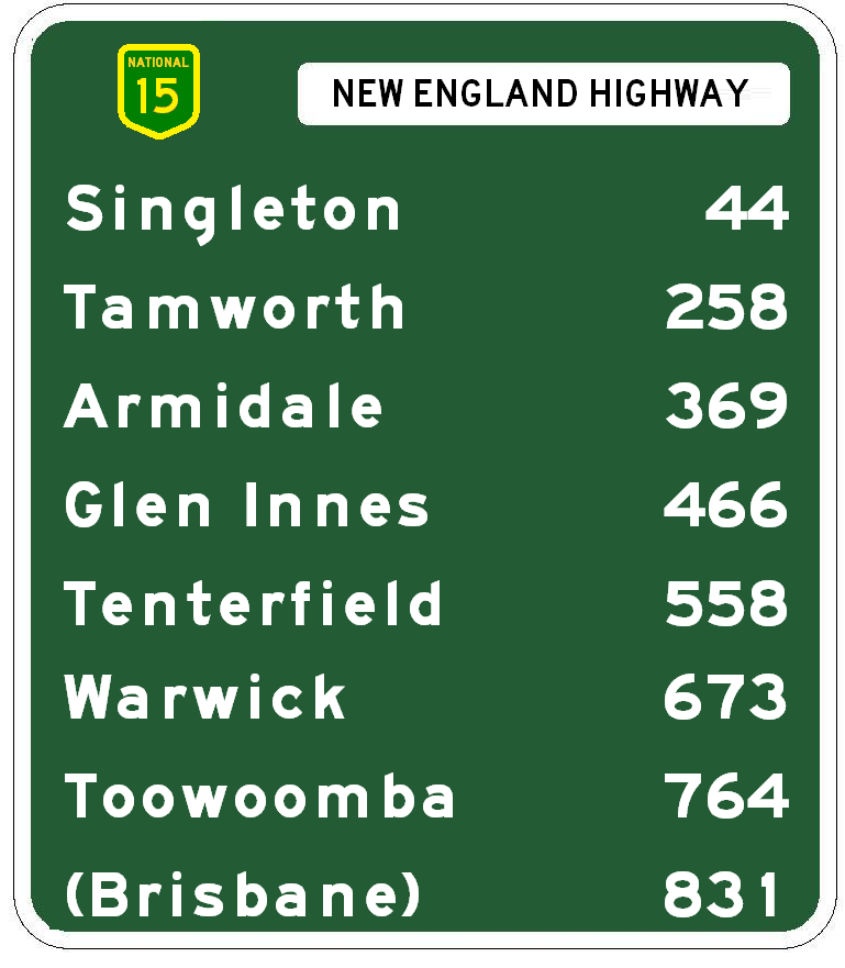
Length 914 km (568 mi) Direction North-South From _ 
 D'Aguilar Highway, Yarraman, Queensland
via Crows Nest, Toowoomba, Warwick, Tenterfield, Glen Innes, Armidale, Tamworth, Muswellbrook, Maitland To  Sydney-Newcastle Freeway /
 Pacific Highway,
Newcastle, New South WalesAllocation Yarraman - Warwick: Formerly
Hampton - Toowoomba:(duplex with )
)
Warwick - NSW/Qld Border:Formerly
NSW/Qld Border - Newcastle:Bendemeer - Tamworth: (duplex with
 )
)Major junctions  Esk-Hampton Road
 Warrego Highway
 Gore Highway
 Cunningham Highway
 Bruxner Highway
 Gwydir Highway
 Waterfall Way
 Oxley Highway
 Fossickers Way
Oxley Highway
 Kamilaroi Highway
 Putty Road
 Golden Highway
- See also: New England Interstate Highways, a system of numbered highways in New England, USA, from 1922 to 1927.
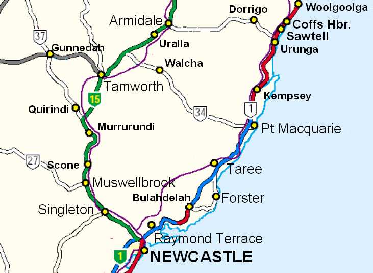
The New England Highway is a highway in Australia running from Hexham near Newcastle at its southern end to Yarraman near Toowoomba at its northern end. At its southern end it connects to the Pacific Highway and at its northern end it connects to the D'Aguilar Highway. It traverses the Hunter Valley and New England regions of New South Wales and the Southern and Darling Downs of Queensland. It is 887 kilometres (551 mi) long.
Contents
Introduction
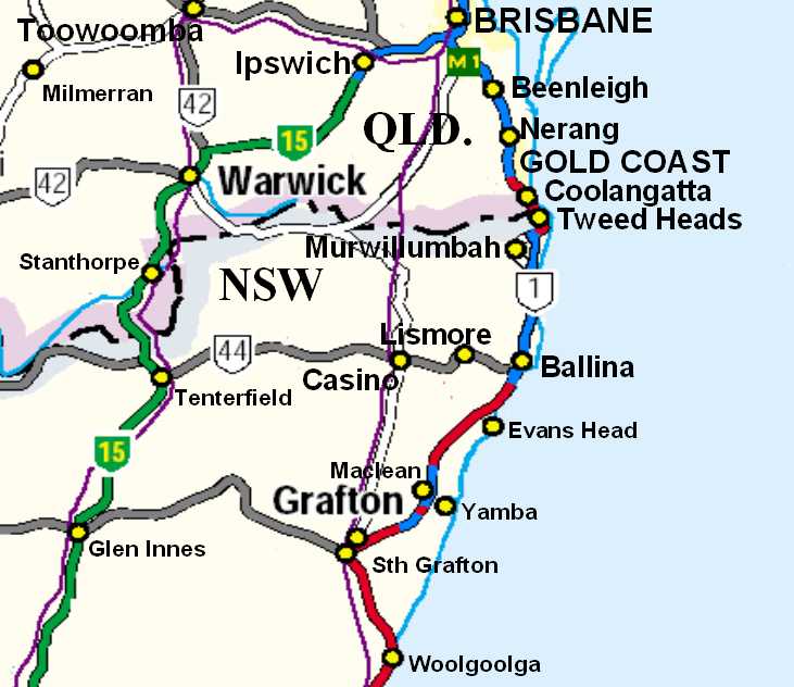
The New England Highway forms the major part of the 1,047 kilometres (651 mi) Sydney-Brisbane national highway route. This route follows the Sydney-Newcastle Freeway (part of national route 1), most of the New England and part of the Cunningham Highway (the parts forming national route 15). The New England Highway north of Warwick is not part of the national highway system.
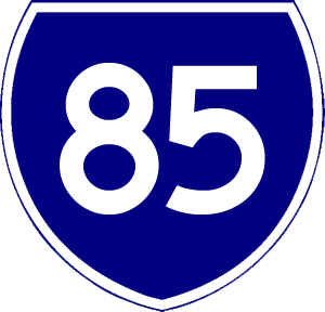
The New England Highway is numbered as part of national route 15 between Hexham and Warwick and part of national route 42 from Warwick to Toowoomba, then Queensland state route 85 from Toowoomba to Hampton, and Queensland state route 61 from Hampton to Yarraman. The highway terminates at Yarraman.
History
The New England Highway has its origins in the track which developed north from Newcastle to reach the prime wool growing areas of the New England region which Europeans settled following expeditions by New South Wales (NSW) Surveyor-General John Oxley in 1818 and botanist Allan Cunningham in 1827 and 1829. It became known as the Great Northern Road.
Improvement was limited during the 19th century, initially due to the lack of traffic and funding, then the transfer of traffic from road to the parallel railway which opened in stages between 1857 and 1888 between Newcastle and Wallangarra.
When the NSW main road system was reorganised in August 1928, the Great Northern Road was gazetted as part of state highway 9, the Great Northern Highway. State highway 9 stretched from Milsons Point on the north shore of Sydney Harbour (at that time the Sydney Harbour Bridge was still under construction) via the under-construction road from Hornsby to Gosford (completed 1930), then via Newcastle to Hexham then to Tenterfield. From Tenterfield it continued to the Queensland border near Mount Lindesay. The only major changes to this route have been a re-routing between Willow Tree and Tamworth to run via Wallabadah rather than via Quirindi and Werris Creek, and a re-routing between Tenterfield and the NSW/Queensland border (see below).
In 1931, state highway 10, the North Coast Highway, which commenced at Hexham and extended to Tweed Heads , was renamed the Pacific Highway and extended south to Milsons Point, so that state highway 9 began at Hexham, as it does today. In 1933 the Great Northern Highway was renamed the New England Highway.
In 1954 main road 374, running from Tenterfield to Wallangarra, was redesignated as part of state highway 9 and named as part of the New England Highway, and the section of the New England Highway from Tenterfield to Mount Lindesay was renumbered as state highway 24 and renamed the Mount Lindesay Highway. The rerouting of the New England Highway from Mount Lindesay to Wallangarra was due to the construction of a sealed road from Boonah through Cunninghams Gap to Warwick in the early 1950s. The sealed road encouraged much more traffic to travel from Brisbane to Tenterfield via Warwick than via Mount Lindesay and the unsealed route on to Tenterfield.
At the time of the rerouting of the New England Highway to Wallangarra and the naming of the Mount Lindesay Highway, arrangements were made by the NSW Department of Main Roads with the Queensland Main Roads Department to name the onward routes from Wallangarra and Mount Lindesay to Brisbane as the New England and Mount Lindesay Highways respectively. At this time they were allocated the national route numbers of 15 for the New England Highway Hexham-Brisbane and 13 for the Mount Lindesay Highway Brisbane-Tenterfield.
National highway function
The national highway network is a subset of the national routes for which the Commonwealth, rather than the state governments, has responsibility for maintenance and upgrading. National route 15 was designated as part of the national highway network when it was established in 1974. This route covers the majority of the New England Highway, from Hexham to Warwick.
Whilst, as a national highway, the New England Highway is part of the official major route between Sydney and Brisbane, most traffic uses the parallel Pacific Highway, which follows the coast. It is therefore the only section of Australia’s national highway network where more traffic uses an alternative route.
Between Warwick and Tamworth the New England Highway, as well as being part of the national route between Sydney and Brisbane, is also an important interstate link between Queensland and Victoria, connecting to Melbourne via the Oxley Highway to the Newell Highway (which becomes the Goulburn Valley Highway where it crosses the Murray River).
Rapid growth of population and tourism along the NSW North Coast since the 1970s led to the Commonwealth and NSW governments jointly funding reconstruction of the Pacific Highway to freeway standard from the early 1990s onward. This work is ongoing - see separate entry on the Pacific Highway. With progressive completion of these roadworks, the New England Highway has become the only national highway route with a lower intercapital traffic volume than an alternative route.
Route numbering
The numbering of the New England Highway is confused by the fact that route names and numbers in Australia are often not contiguous or consistent with each other. In addition, in Queensland there have been numerous name and number changes and extensions to the New England Highway since 1970.
At the time of the rerouting of the New England Highway to Wallangarra and the naming of the Mount Lindesay Highway, arrangements were made by the NSW Department of Main Roads with the Queensland Main Roads Department to name the onward routes from Wallangarra and Mount Lindesay to Brisbane as the New England and Mount Lindesay Highways respectively. At this time they were allocated the national route numbers of 15 for the New England Highway Hexham-Tenterfield-Warwick-Brisbane and 13 for the Mount Lindesay Highway Brisbane-Tenterfield.
In the 1970s, the Queensland Main Roads Department rerouted the designation of the New England Highway north of Warwick to follow the former Lockyer-Darling Downs Highway (national route 17) so that it terminated in Toowoomba. The section of the highway between Brisbane and Warwick was renamed as part of the Cunningham Highway, which until that time had extended only westward from Warwick to Goondiwindi. The rerouted section of the New England Highway from Warwick to Toowoomba was renumbered from 17 to become part of national route 42, which until then also had only extended westward from Warwick to Goondiwindi. In the 1990s, the Main Roads Department extended the name New England Highway north from Toowoomba to the D'Aguilar Highway at Yarraman, but this section carries state route numbers, rather than a national route number. However it carries little traffic and performs a regional rather than a national function.
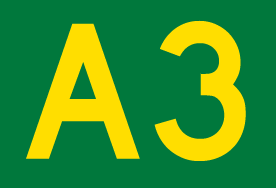
The NSW Roads and Traffic Authority is quietly implementing an unannounced state-based alpha-numeric route numbering system, abandoning the national route system used since the 1950s and the complementary state route numbering system used since the 1970s. No details of when this is to be completed have been announced. However, many alpha-numeric route signs are appearing on roads throughout the state, including the New England Highway. An example of this signage is on the bypass of Armidale, where the route number 'A15' appears.
Track
 From Brisbane, National Highway 15 (green) follows the Cunningham Highway until Warwick where it then follows southwards, the New England Highway ...

The first section of the New England Highway west from Hexham to Maitland is dual carriageway, with the towns en route to Maitland bypassed. This section is partially grade separated, and carries heavy amounts of local traffic, with a large proportion of the traffic being trucks. In Maitland the highway continues via a dual carriageway CBD bypass to Telarah, from which point it reverts to single carriageway. Beyond Maitland, the only sections of dual carriageway are through Belford Forest west of Branxton, the 1966 deviation around Lake Liddell near Muswellbrook, the crossing of the Liverpool Range at Nowlands Gap immediately north of Murrurundi through South Tamworth, and the ascent of the Moonbi Range between Tamworth and Bendemeer.
As far as Muswellbrook the highway carries heavy industrial traffic associated with the extensive coal mining in the Hunter Valley. Duplication of the highway and bypasses of towns as far as Muswellbrook is propsoed by the Roads and Traffic Authority, but this propsal is unfunded with no timetable for its undertaking. Beyond Muswellbrook traffic volumes do not justify dual carriageways on most sections of the highway. The main substandard sections of the highway are generally in the upper Hunter Valley around Parkville, Wingen and Blandford. Once the highway climbs the Liverpool Range to the Northern Tablelands, most sections provide excellent driving.
In recent years the main upgrading activities in the Highway have been the deviation and duplication through Belford Forest, deviation and duplication over the Liverpool Range immediately north of Murrurundi, the Tamworth CBD bypass (an upgrading of an existing road), the Bendemeer bypass, the Armidale bypass, and deviations at Black Mountain and the Devils Pinch north of Armidale.
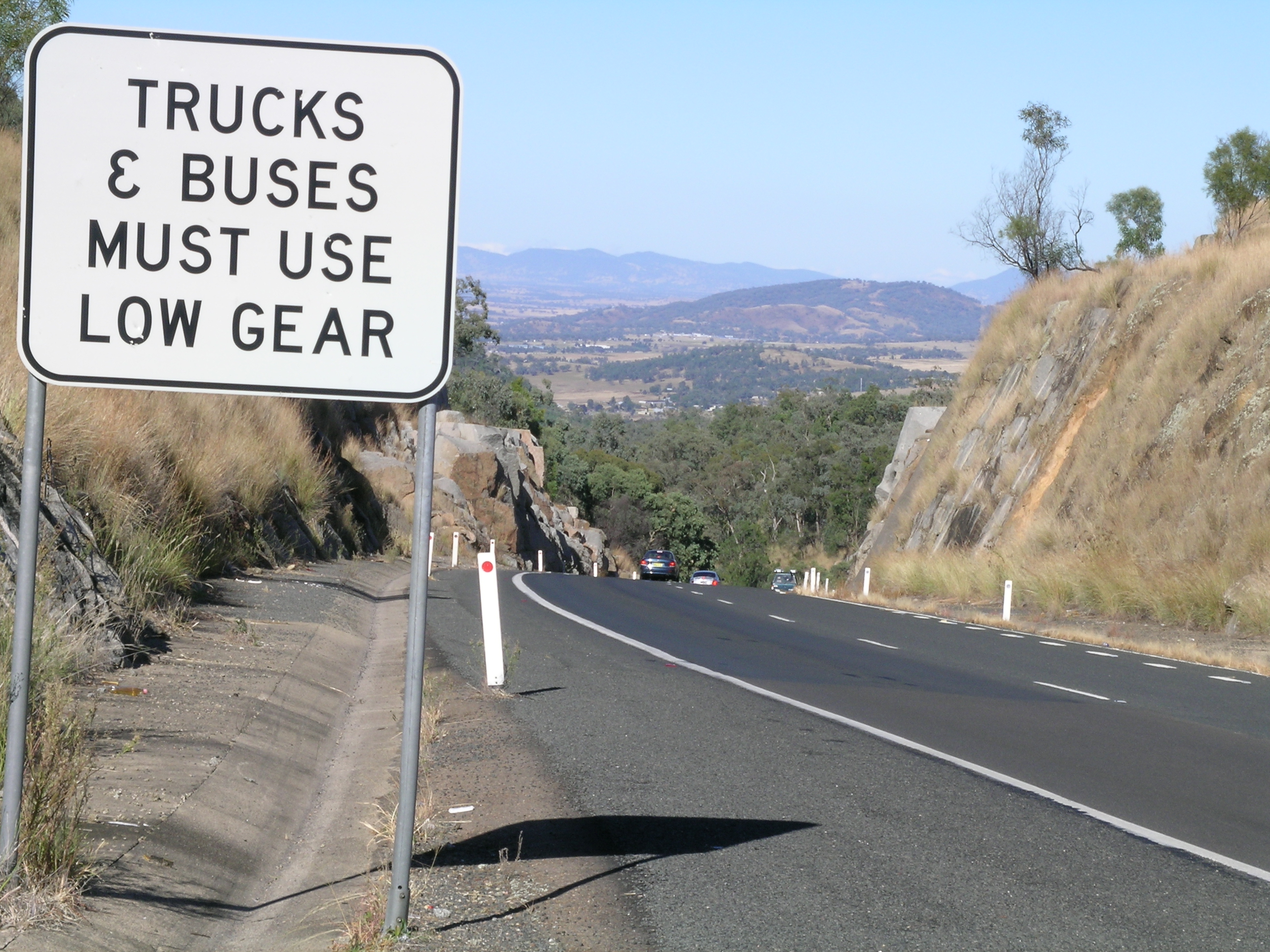
Long lengths of the New England Highway are subject to severe frost and snowfall, with the 350 km section from the Moonbi Ranges to Stanthorpe located at high altitudes. The highest point on the Highway is where it crosses the Ben Lomond Range halfway between Armidale and Glen Innes.
Speed cameras have been installed on the New England Highway at:
- Lochinvar – between Robert Road and Station Lane
- Scone – between Eveleigh Circuit and Forbes Street
- Blandford – between Hayles Street and Mills Street
- Murrurundi – between Bernard Street and Adelaide Street
- Ben Lomond – between Ross Road and Ben Lomond Road
- Wallabadah – between Gaspard Road and Lowestoft Road
- Kootingal – between Gill Street and Yarrol Road
- Tilbuster – between Sunnyside Road and Tilbuster Ponds Bridge
- Llangothlin – between Ben Lomond Road and Everetts Road
- Tenterfield – between Duncan Street and George Street.
 Intersection of New England Highway and Golden Highway between Branxton and Singleton
 Thunderbolts Rocks, New England Highway (south of Uralla), where Thunderbolt conducted some of his robberies.
 Statue of Captain Thunderbolt at the intersection of New England Highway and Thunderbolts Way, Uralla, NSW
Highway improvements
The major projects since the Second World War in the ongoing upgrading of the New England Highway are:
- Hexham-Tarro duplication (including Tarro railway overpass) (1964)
- Tarro-Beresfield bypass (dual carriageway) (Oct 1970)
- Tarro interchange (to connect to Anderson Drive) (May 1994)
- John Renshaw Drive interchange (Sep 1997)
- Weakleys Drive interchange (2008)
- Beresfield-East Maitland duplication (final stage Aug 1982)
- Maitland inner city bypass stage 1 (dual carriageway) (Feb 1986)
- Maitland inner city bypass stage 2 (dual carriageway) (Dec 1986)
- Maitland inner city bypass Stage 3 (dual carriageway) (Sep 1988)
- Widening to four lanes from the Long Bridge Telarah to Harvey Rd Rutherford (Aug 1982)
- Belford Forest deviation (dual carriageway) (Oct 1998)
- Deviation at Singleton including new bridge over Hunter River (May 1986)
- Chilcotts Creek deviation (Dec 1968)
- Liddell deviation (including 2 km dual carriageway) to allow creation of Lake Liddell (Jan 1967)
- Muswellbrook (north) railway overpass (May 1966)
- Duplication of 1893 bridge, Hunter River at Aberdeen for northbound traffic (each bridge since reconfigured to one lane only (Dec 1986)
- Reconstruction to four lanes along Kelly St Scone (1985)
- Halcombe Hill deviation (1 km north of Aberdeen) (Aug 2007)
- Bridge over Pages River at Blandford (previously a ford) (now used for southbound traffic) (Dec 1953)
- Duplicate bridge for northbound traffic, Pages River at Blandford (each bridge configured for one lane only) (2004)
- Liverpool Range deviation (dual carriageway), Murrurundi-Nowlands Gap (Oct 1994)
- Liverpool Range duplication (Nowlands Gap-Kankool) (Jan 1997)
- New bridge over Peel River in Tamworth (replaced 1881 bridge) (Apr 1965)
- Tamworth CBD bypass (upgrade of Calare Lane) (Nov 1993)
- Tintinhull realignment (Dec 1986)
- First Moonbi Hill duplication (1937 deviation retained as northbound carriageway) (Aug 1982)
- Rose Valley Creek deviation (33-36 km north of Tamworth) (2002)
- Bendemeer bypass (Dec 1985)
- Barleyfields deviation, Uralla (Feb 1980)
- Armidale bypass (Dec 1994)
- Duval Creek realignment (13-15 km north of Armidale) (Dec 2004)
- Realignment of highway at Tilbuster, near Sunnyside Rd (17-19 km north of Armidale) (Feb 2010)
- Devil's Pinch deviation stage 1 (Dec 1982)
- Devil's Pinch deviation stage 2 (May 1983)
- Devil's Pinch deviation stage 3 (22-27 km north of Armidale) (2002)
- Devil's Pinch (Black Mountain) deviation stage 4 (27-30 km north of Armidale) (April 2006)
- Guyra-Llangothlin deviation (Dec 1970)
- Marowan Creek bridge replacement, Glencoe (1995)
- Bolivia Hill deviation (Mar 1951)
- Stanthorpe bypass (1960s)
- Allora bypass (1960s)
- Harristown/Drayton deviation (1970s).
Current projects
- Freeway from Newcastle Freeway at Newcastle link road to beginning of Belford Forest deviation west of Branxton (40 km, $1.7 billion, scheduled for completion 2013) (see article Hunter Expressway)
Future projects
- Muswellbrook bypass (single carriageway, 6 km) (no date).
Cities and towns
From its junction with the Pacific Highway at Hexham, 12 km inland from Newcastle the New England Highway connects the following cities and towns:
- Maitland
- Greta
- Branxton
- Singleton
- Muswellbrook
- Aberdeen
- Scone
- Murrurundi
- Tamworth
- Bendemeer
- Uralla
- Armidale
- Guyra
- Glen Innes
- Tenterfield
In Queensland
Below is a short description of some of the towns on the New England Highway.
Maitland
Maitland was the original centre of European settlement in the Hunter Valley. In the early 19th century the focus was on food rather than coal, and the rich river flats around Maitland provided food for the young colony. It was not until the late 19th century that Newcastle eclipsed Maitland as the centre of the Hunter Valley. Nonetheless, Maitland retains a major role as an industrial centre, with a population of 55,000. In 1955 the city was severely damaged by flooding of the Hunter River.
Singleton
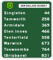 Approximate distances in kilometres from Newcastle
 New England Highway on the 1st Moonbi Hill.
The major centre for the mid-Hunter Valley, with 13,000 residents. Although the Singleton district is dotted with vineyards and the town has grown in the past three decades, unlike many other country towns, this was due to employment in the coalmining industry and as a dormitory for Newcastle. A major army base is located nearby. The scenic but isolated Putty Road (state route 69) connects Singleton with Windsor and Sydney's northwestern suburbs.
Muswellbrook
The major centre of the Upper Hunter Valley, with a population of over 12,000. Nearby are two of NSW's two major power stations - Liddell (built 1968) and Bayswater (built 1981), which together account for over 40% of the electricity produced in NSW. The town has wide streets set in a sweeping pastoral landscape, and St Alban's Anglican church in the town was designed by famous English architect Giles Gilbert Scott. Muswellbrook is the centre of major coal mining and wine producing areas, as well as thoroughbred horse breeding and agriculture.
Scone
A town renowned for its thoroughbred stud farms and regarded as the horse capital of Australia. Around Scone the Hunter Valley narrows and the sandstone escarpments enclosing the valley provide a stunning backdrop to the rolling green hills of the valley floor. North of Scone and adjacent to the Highway is Mount Wingen - the Burning Mountain - where a light but constant plume of smoke issues from fissures in the ground, caused by lightning setting fire to coal seams close to the surface tens of thousands of years ago.
Tamworth
Set on the Peel River, Tamworth is the largest city in inland northern NSW with 35,000 inhabitants, and is the centre of a rich agricultural district. It is also a thriving industrial and commercial centre. Famous as the 'Country Music Capital' of Australia and its annual Tamworth Country Music Festival. The Australian Equine and Livestock Events Centre (AELEC) is located on the New England Highway on the southern outskirts of the city. In 1888 it became the first town in Australia to install electric street lighting.
Armidale
Located on the Northern Tablelands, Armidale's high altitude (over 1,000 m) gives it four pronounced seasons. It is also the hub of a thriving pastoral area famous for its high quality wool. The University of New England, established in 1954, and is the main seat of learning in inland northern NSW and is a major employer. The student population makes up a significant proportion of the city's population of 22,000. Armidale features beautiful landscapes, parks and historic buildings. Also of note is the Hinton Art Gallery, which houses the Felton Bequest, a significant collection of work by Australian artists.
Glen Innes
A Celtic-flavoured town that owes much to the Scottish settlers who came to the district in the 1830s. A monument commemorates the part they played. 40 km east of Glen Innes along the Gwydir Highway are the world heritage areas of the Washpool rainforests.
 Bluff Rock, New England Highway, Tenterfield, NSW
Tenterfield
Known as the Birthplace of Federation, being the town where NSW Premier Henry Parkes delivered his Tenterfield Oration, making the case for federation of the colonies into the Commonwealth of Australia. The architecture of the 1886 railway station is of note for its ornateness and excellent state of preservation. It is also the hometown of the entertainer Peter Allen.
Wallangarra
The New England Highway crosses the State border into Queensland at Wallangarra, famous for the railway break of gauge on the only rail link between Sydney and Brisbane from 1888 until the coastal standard gauge line was completed in 1930. Much of the railway yards needed for transhipping passengers and goods between the trains on the two different gauges remains.
Stanthorpe
Located just off the New England Highway, set at a high altitude in granite country and famous for its wineries and orchards. The outstanding Girraween National Park to the south of Stanthorpe has excellent bushwalking and rockclimbing.
Warwick
Major centre of the Southern Downs with a population of 11,000, Warwick is set in rolling pastoral country on the banks of the Condamine River. Famous for its rose gardens and rodeo. From 15 km north of Warwick, national route 15 turns east to Cunninghams Gap and down into the Brisbane Valley via the Cunningham Highway to reach Ipswich. From here Brisbane is only another 30 km.
Toowoomba
With a population of 90,000, Toowoomba is one of Australia's major rural cities. Noted for its beautiful gardens as result of rich volcanic soils, it is home to the University of Southern Queensland and is the commercial and administrative centre of the Darling Downs region.
See also
- Highways in Australia
- WikiTravel - New England Highway
- List of highways in New South Wales
- List of highways in Queensland
- Moonbi Range
- Hunter Expressway
References
External links
 Road Infrastructure in Newcastle
 Sydney-Newcastle Freeway ·
  New England Highway ·
  Pacific Highway ·
  Newcastle Inner City Bypass · Hunter Street ·
  Hunter Expressway (under construction)
 Road infrastructure in Queensland
Motorways National Highways Barkly Highway • Bruce Highway • Cunningham Highway • Gore Highway • Landsborough Highway • Leichhardt Highway • New England Highway • Warrego HighwayHighways Balonne Highway • Barwon Highway • Brisbane Valley Highway • Burnett Highway • Bunya Highway • Capricorn Highway • Captain Cook Highway • Carnarvon Highway • Castlereagh Highway • Centenary Highway • D'Aguilar Highway • Dawson Highway • Donohue Highway • Flinders Highway • Gold Coast Highway • Gregory Highway • Isis Highway • Kennedy Highway • Leichhardt Highway • Mary Valley Highway • Mitchell Highway • Moonie Highway • Mount Lindesay Highway • Mulligan Highway • Outback Highway • Palmerston Highway • Peak Downs Highway • Wide Bay HighwayDevelopmental Roads /
Outback TracksBirdsville Track • Burke Developmental Road • Gregory Developmental Road • Gulf Developmental Road • Kennedy Developmental Road • Savannah WayProposals Significant places and items of interest in the Hunter Region of New South Wales Commerce and industry IndustryDarley Stud • Hunter Valley Coal Chain • Hunter Valley wine • Kia-Ora stud • Kooragang Island • Newcastle Port Corporation • Tomago aluminium smelterShoppingOtherEducation PrimarySecondaryAll Saints College, St Joseph's Campus • Avondale School • Hunter School of the Performing Arts • Hunter Valley Grammar School • Irrawang High School • Lambton High School • Maitland Grossmann High School • Maitland High School • Merewether High School • Newcastle Grammar School • Newcastle High School • Rutherford Technology High School • Tomaree High SchoolTertiaryEntertainment, sport & culture Broadmeadow Basketball Stadium • Dungog Film Festival • Hunter Valley Steamfest • Newcastle Civic Theatre • Newcastle Entertainment Centre • Newcastle International Sports Centre • Newcastle Number 1 Sports Ground • Newcastle Regional ShowGeography GeneralBroughton Island • Burning Mountain • Cape Hawke • Glenrock Lagoon • Lake Macquarie • Myall Lakes • Mount Royal Range • Mount Sugarloaf • Port Stephens • Stockton Beach • Tops to Myall Heritage TrailNational parksBarrington Tops National Park • Black Bulga State Conservation Area • Booti Booti National Park • Ghin-Doo-Ee National Park • Mount Royal National Park • Myall Lakes National Park • Tomaree National Park • Towarri National Park • Wallingat National Park • Watagans National Park • Werakata National ParkRiversAvon River • Barrington River • Chichester River • Gloucester River • Goulburn River • Hunter River • Karuah River • Manning River • Myall River • Pages River • Paterson River • Williams RiverHistorical Air transportDefenceEducationGeneralHistory of Newcastle, New South Wales • Hunter Valley cannabis infestation • Lake Macquarie Petrified Forest • Maitland Gaol • Nobbys Head • Royal Newcastle Hospital • Tahlee historic propertyIndustryCockle Creek Power Station • Cockle Creek Smelter • South Maitland coalfields • South Waratah Colliery • State Dockyard • Teralba Colliery • Walka Water Works • Wangi Power StationMaritimeNatural disasters1989 Newcastle earthquake • June 2007 Hunter Region and Central Coast storms • Seaham bushfires (1939)PeopleRailGeneralHunter Valley Railway Trust • Hunter Valley Steamfest • Murulla rail accidentRailway linesBelmont railway line • East Maitland – Morpeth railway line • Fernleigh Track • Richmond Vale Railway • South Maitland Railway • Toronto railway lineRailway stationsTramsWine makingWorld War IINo. 2 Fighter Sector RAAF • No. 208 Radar Station RAAF • HMAS Assault • Belmont Anti-Tank Ditch • Lake Macquarie anti-submarine boom • Newcastle Covering Force • RAAF Base Rathmines • Shelling of NewcastleInfrastructure TransportRoadBus routes in Newcastle, New South Wales • Bucketts Way • Golden Highway • Hunter Expressway • New England Highway • Newcastle Inner City Bypass • Pacific Highway • Putty Road • Sydney-Newcastle Freeway • Tea Gardens-Hawks Nest Bridge • Thunderbolts WayRailway linesHunter • Main North • Newcastle and Central CoastRailway stationsAberdeen • Adamstown • Awaba • Beresfield • Booragul • Branxton • Broadmeadow • Cardiff • Civic • Cockle Creek • Dora Creek • Dungog • East Maitland • Fassifern • Glendale • Greta • Hamilton • Hexham • High Street • Hilldale • Kotara • Lochinvar • Maitland • Martins Creek • Metford • Mindaribba • Morisset • Muswellbrook • Newcastle • Paterson • Sandgate • Scone • Singleton • Tarro • Telarah • Teralba • Thornton • Victoria Street • Wallarobba • Warabrook • Waratah • Wickham • Wirragulla • WyeeAirUtilitiesElectricity generationBayswater Power Station • Eraring Power Station • Lake Liddell • Liddell Power Station • Redbank Power Station • Teralba Colliery • Vales Point Power StationWater supplyMedia Other DefenceGeneralHospitalsCategories:- Australian highways
- Maitland, New South Wales
- Newcastle, New South Wales
- Transport in Hunter Region, New South Wales


Wikimedia Foundation. 2010.