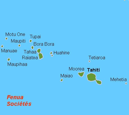
- Moorea
-
Moʻorea 
Aerial view of Moʻorea
Geography Location Pacific Ocean Coordinates 17°32′S 149°50′W / 17.533°S 149.833°WCoordinates: 17°32′S 149°50′W / 17.533°S 149.833°W Archipelago Society Islands Area 134 km2 (51.7 sq mi) Highest elevation 1,207 m (3,960 ft) Highest point Mont Tohiveʻa Country FranceOverseas collectivity French Polynesia Administrative subdivision Windward Islands Commune Moʻorea-Maiʻao Largest city Paopao–Maharepa
(4,244 inhabitants)Demographics Population 16,191[1] (as of Aug. 2007 census) Density 121 /km2 (313 /sq mi) Moʻorea (Tahitian pronunciation: \ˌmō-ō-ˈrā-ä, ˈmō-ō-ˌrā-\[2]) is a high island in French Polynesia, part of the Society Islands, 17 km (roughly 9 mi) northwest of Tahiti. Its position is 17°32′S 149°50′W / 17.533°S 149.833°W. Moʻorea means "yellow lizard" in Tahitian. An older name for the island is ʻAimeho, sometimes spelled 'Aimeo or ʻEimeo (among other spellings misunderstood by early visitors with no knowledge of the language). Early Western colonists and voyagers also referred to Moʻorea as York Island.
Contents
Transportation
Several ferries go to the Vai'are wharf in Mo'orea daily from Papeetē, the Tahitian capital. The Vai'are wharf is in the Vai'are bay. There are 3 ferries. One of them is the 'Aremiti 5. The largest one is the 'Aremiti Ferry and the other one is the Moorea ferry. The ferries have to pass through Mo'orea's coral pass, then toward Papeetē across the ocean and into the Tahiti Lagoon. The Vai'are bay is in the east part of Mo'orea. Mo'orea's Temaʻe Airport (MOZ) has connections to the international airport in Papeetē and onward to other Society Islands such as Pora Pora. If the islanders want to make an international flight, they would take Air Tahiti to get to the Fa'a'a International Airport on Tahiti. The Mo'orea airport is located north of the Vai'are bay. There is one road that goes around the island. Along the road are kilometer markers from 1 to 35. The first one is near the airport. The 35th one is in Ha'apiti. There are also white signs that tell the driver which commune they entered. Other signs have the communes name with a red slash through it, meaning that the driver is leaving the commune.
Geography
Mo'orea is about 10 miles in width from the west to the east. There are two small, nearly symmetrical bays on the north shore. The one to the west is called 'Ōpūnohu Bay which isn't very populated but many travelers have come into the bay. The main surrounding communes of the bay are Piha'ena in the east and Papeto'ai to the west. The one to the east is Cook's Bay, also called Pao Pao Bay since the largest commune of Mo'orea is at the bottom of the bay. The other communes are Piha'ena to the west and busy Maharepa to the east. The highest point is Mount Tohi'e'a, near the center of Mo'orea. It dominates the vista from the two bays and can be seen from Tahiti. There are also hiking trails in the mountains. The Vai'are Bay is another small inlet, smaller than the two main bays, on the east shore. This bay has been settled a lot and has a lot of business. The main village is located just south of the bay.
Politics
The island is administratively part of the commune (municipality) of Moʻorea-Maiʻao, itself in the administrative subdivision of the Windward Islands. The main village is ʻĀfareaitu.[3] The largest village is Pao Pao at the bottom of Cook's bay. The 2nd largest is Maharepa.
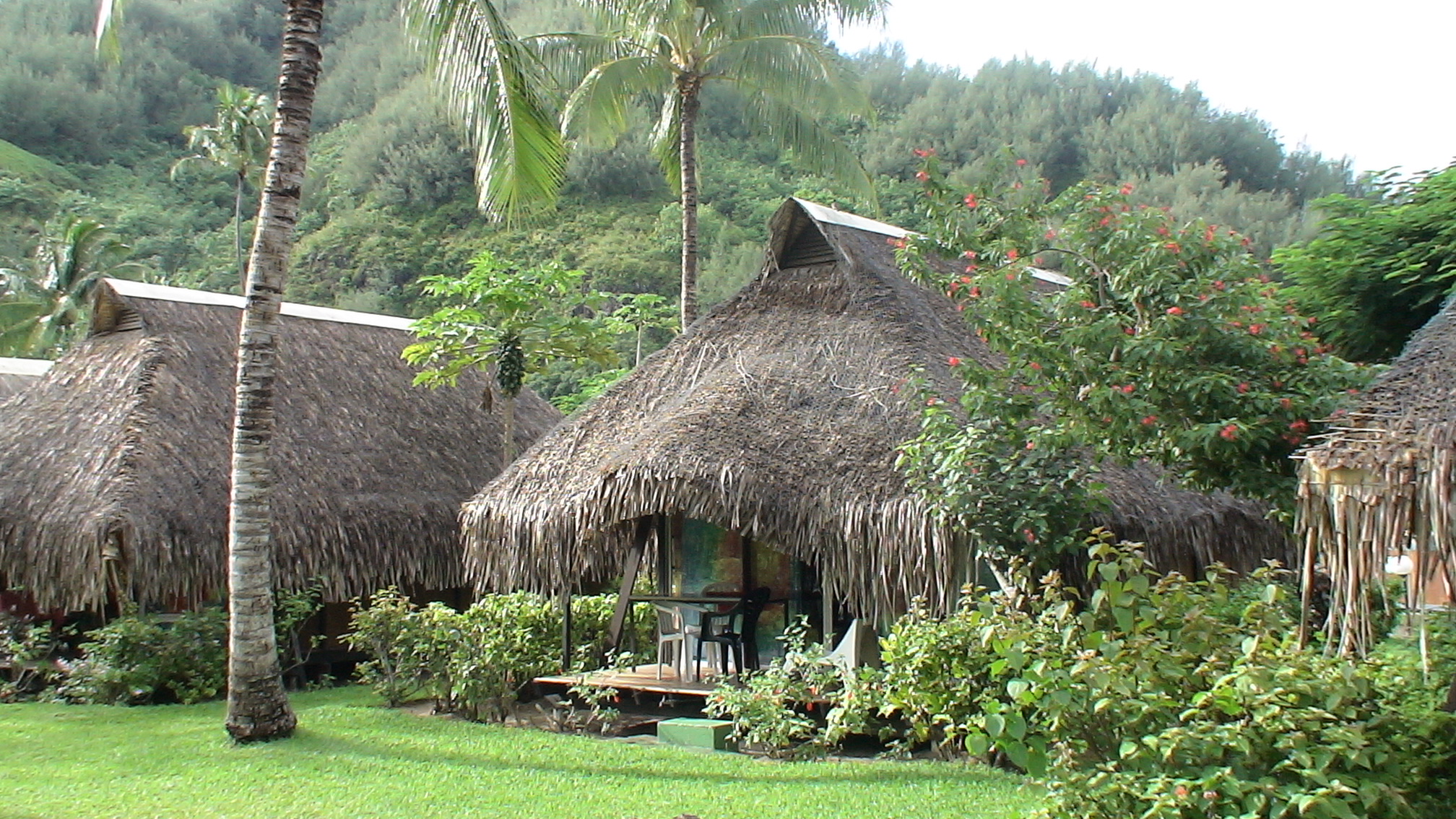
Tourism
 Bungalows of Hotel Hibiscus, Hauru Point, Moʻorea
Because of its stunning scenery and accessibility to Papeetē, Moʻorea is visited by many western tourists who travel to French Polynesia. Especially popular as a honeymoon destination, Moʻorea can often be seen in advertisements in American wedding magazines. Authur Frommer declared in Frommer's travel guide that he considered it the most beautiful island in the world.[4]
Physical description
 Map of Moʻorea and Tahiti
From above, the shape of the island vaguely resembles a heart, with its two nearly symmetrical bays opening to the north side of the island: Cook's (or Paopao) Bay and ʻŌpūnohu Bay. The island was formed as a volcano 1.5 to 2.5 million years ago, the result of a geologic hotspot in the mantle under the oceanic plate that formed the whole of the Society Archipelago. It is theorized that the current bays were formerly river basins that filled during the Holocene searise.
History
Like many of the other islands, Mo'orea was first settled by Polynesian from the islands west of Mo'orea. They arrived on canoes coming down from South Asia looking for islands to settle. They arrived to Mo'orea 1000 years ago. There are some ancient landmarks like Marae. Marae are anciant stone rocks that are shaped like pyramids. On the rocks are carvings that tell when sacrifices sometimes took place. The oldest marae is the 'Āfareaitu Marae located in the island's main village. It was made by the early Polynesians in the year 900. People can easily visit the 'Āfareaitu Marae. The first settlers who were Europeans arrived during the 18th century. The first European to arrive on the island were Englishman Samuel Wallis and James Cook. Captain James Cook first settled on Tahiti and then he took his ship with Samuel Wallis and then he went onward to Mo'orea. Then the bay that he first settled in was Cook's bay which was later named after him.[clarification needed]
Then was the French Tahitian War. The French won because they had guns and the Tahitians had only had knives and picks. Most of the Tahitians that fought were from Papeto'ai. Then Mo'orea was considered to be part of French Polynesia. Charles Darwin was inspired for his theory regarding the formation of coral atolls when looking down upon Moʻorea standing on a peak on Tahiti. He described it as a "picture in a frame", referring to the barrier reef encircling the island. Don the Beachcomber lived here for some time until his houseboat was destroyed by tropical cyclones.In the early 1900s, people started to make fire from leaves they didn't need so they could cook their food.
The island was among those visited by the United States Exploring Expedition on its tour of the South Pacific in 1839. Then transportation began Mo'orea. They built the main road and the Vai'are wharf. It took the Polynesians about 4 years to construct the 3 ferries that go daily from Mo'orea to Tahiti. Each of the ferries has different speeds. Then on October 7, 1967,the construction workers have finished building the Mo'orea Airport and the airport opened the next month. A group on Moʻorea island has succeeded in attracting about 100 people to attend a meeting of a purported new republic, called Hau Pakumotu in 2010. To this day, Mo'orea is visited a lot.Research facilities
The University of California, Berkeley maintains the Richard B. Gump South Pacific Research Station[5] on the west coast of Cook's Bay. The Gump station is also home to the Moʻorea Coral Reef Long Term Ecological Research Site (MCR LTER). The project, funded by the US National Science Foundation (NSF), is a partnership between the University of California Santa Barbara and California State University, Northridge that includes additional researchers from UC Davis, UC Santa Cruz, UC San Diego and the University of Hawaiʻi. The Moʻorea Coral Reef LTER is part of the National Science Foundation's Long Term Ecological Research (LTER) Network. The LTER Program was established by the NSF in 1980 to support research on long-term ecological phenomena. The Mo'orea Coral Reef LTER became the 26th site in the LTER network in September 2004.
 Cook's Bay with Mouʻa Puta (left), Mouʻa Roa, aka Mt Bali Hai (center), Mount Rōtui (right; October 2008)
The French EPHE (École pratique des hautes études) and now the CNRS (National Centre for Scientific Research) maintain a research station at the end of ʻŌpūnohu Bay since about 1970. This Centre de Recherches Insulaires et Observatoire de l'Environnement (Centre for island research and environment observatory) or CRIOBE is a research site for several international projects, including the monitoring of coral reefs throughout French Polynesia as well as the monitoring of the fish population on the Tīahurā transect of Moʻorea's reef for over 30 years.
See also
References
- ^ (French) Institut Statistique de Polynésie Française (ISPF). "TABLEAU II Population des communes et communes associées de Polynésie française" (PDF). Archived from the original on 2008-02-29. http://web.archive.org/web/20080229183317/http://www.ispf.pf/(k1aciwf4z0fyap45ghzhgm55)/stat/demo/rp2007/pdfs/poplegales_commass2007.pdf. Retrieved 2007-12-02.
- ^ "Mooréa". Merriam-Webster Dictionary. October 3, 2011. http://www.merriam-webster.com/dictionary/moorea.
- ^ http://www.pacific-image.pf/pages/boutic/dboutic_cdrom_sp132.html
- ^ "Frommer's The Most Beautiful Islands". 2010-03-02. http://www.frommers.com/destinations/southpacific/0240020917.html. Retrieved 2010-03-02.
- ^ Richard B. Gump South Pacific Research Station
External links
- Official site (Tahiti Tourisme Board)
- Moʻorea Visitors Bureau
- Moʻorea Travel Information
- Directory: direct links about Moʻorea
- Photogallery of Moʻorea
- Moʻorea Coral Reef Long Term Ecological Research Site
- U.C. Berkelely Richard B. Gump South Pacific Research Station
- Photos of Moʻorea
- "Surgical Strike: Moʻorea Surf Mission" Photos And Video
- The Island of Moʻorea at the Smithsonian Ocean Portal

 List of resources about traditional arts and culture of Oceania
Art ahu · Australia · Austronesia · Cook Islands · Hawaiʻi · kapa (Hawaiʻi) · lei (Hawaii) · magimagi · Māori · moai · New Zealand · nguzu nguzu · Oceania · Papua New Guinea · reimiro · tā moko · tapa ["masi" (Fiji), "ngatu" (Tonga), "siapo" (Sāmoa), " ʻuha" (Rotuma)] · tabua · ta'ovala · tattoo · tēfui · tivaivaiBroad culture Geo-specific, general Australia · Australian Aboriginal astronomy · Austronesia · Caroline Islands, -Pwo · Chatham Islands · Cook Islands · Easter Island · Fiji, -Lau Islands, -traditions and ceremonies · Guam · Hawaiʻi, -Lomilomi massage · Kiribati · French Polynesia's Marquesas Islands · Marshall Islands, -Stick charts of · Federated States of Micronesia · Nauru · New Caledonia · New Zealand · Niue · Norfolk Island · Palau · Papua New Guinea · Pitcairn Islands · Sāmoa · Solomon Islands · Tonga · Torres Strait Islands · Tuvalu · Vanuatu · Wallis and Futuna · Yap, -navigation, -Weriyeng navigation schoolCanoes Aboriginal Dugout · Alingano Maisu · Drua · Dugout (boat) · Hawaiʻiloa · Hōkūleʻa · Modern Hawaiian outrigger · Māori migration · Outrigger · Polynesian sailing · Proa · Waka,-List of · WalapDance Festivals Australia's Garma Festival · Hawaiʻi's Aloha Festivals, Merrie Monarch Festival, and World Invitational Hula Festival · Fiji · New Zealand's Pasifika Festival · The Pacific Community's Festival of Pacific Arts · Festivals in Papua New GuineaLanguages by areaLanguages of Oceania Sovereign states - Australia
- East Timor (Timor-Leste)
- Fiji
- Indonesia
- Kiribati
- Marshall Islands
- Federated States of Micronesia
- Nauru
- New Zealand
- Palau
- Papua New Guinea
- Samoa
- Solomon Islands
- Tonga
- Tuvalu
- Vanuatu
Dependencies and
other territories- American Samoa
- Christmas Island
- Cocos (Keeling) Islands
- Cook Islands
- Easter Island
- French Polynesia
- Guam
- Hawaii
- New Caledonia
- Niue
- Norfolk Island
- Northern Mariana Islands
- Pitcairn Islands
- Tokelau
- Wallis and Futuna
by categoryLiterature Literature of Oceania Sovereign states - Australia
- East Timor (Timor-Leste)
- Fiji
- Indonesia
- Kiribati
- Marshall Islands
- Federated States of Micronesia
- Nauru
- New Zealand
- Palau
- Papua New Guinea
- Samoa
- Solomon Islands
- Tonga
- Tuvalu
- Vanuatu
Dependencies and
other territories- American Samoa
- Christmas Island
- Cocos (Keeling) Islands
- Cook Islands
- Easter Island
- French Polynesia
- Guam
- Hawaii
- New Caledonia
- Niue
- Norfolk Island
- Northern Mariana Islands
- Pitcairn Islands
- Tokelau
- Wallis and Futuna
Music Austral Islands (French Polynesia) · Australia · Austronesia · Cook Islands · Easter Island · Fiji · Guam · Hawaiʻi · Kiribati · Lali · Māori · Melanesia · Northern Mariana Islands · Micronesia · Federated States of Micronesia · Nauru · New Caledonia · New Zealand · Niue · Palau · Papua New Guinea · Polynesia · Sāmoa · Slit drum · Solomon Islands · Tahiti · Tokelau · Tonga · Tuvalu · Vanuatu · Wallis and FutunaMythology Australian Aboriginal · Fijian · Māori · Melanesian · Menehune · Micronesian · Oceanian legendary creatures · Polynesian · Rapa Nui · VanuatuPeople Indigneous Australian · Austronesian · Chamorro · Chatham Islander (Moriori or Rekohu) · Fijian · Hawaiian (kānaka maoli) · Māori · Marshallese · Melanesian · Micronesian · Negrito · Norfolk Islander · Papuan · Polynesian · Indigenous Polynesian (Mā’ohi) · Rapanui · Rotuman · Samoan · Tahitian · Tongan · Torres Strait IslanderReligion Religion in Oceania Sovereign states Dependencies and
other territories- American Samoa
- Christmas Island
- Cocos (Keeling) Islands
- Cook Islands
- Easter Island
- French Polynesia
- Guam
- Hawaii
- New Caledonia
- Niue
- Norfolk Island
- Northern Mariana Islands
- Pitcairn Islands
- Tokelau
- Wallis and Futuna
Not included: Oceanian: cinema, (indigenous) currency, dress, folkore, cuisine. Also see Category:Oceanian culture.Categories:- Islands of the Society Islands
- Volcanoes of French Polynesia
- Pliocene volcanoes
- Pleistocene volcanoes
- Extinct volcanoes


Wikimedia Foundation. 2010.