- Maidstone, Victoria
-
Maidstone
Melbourne, Victoria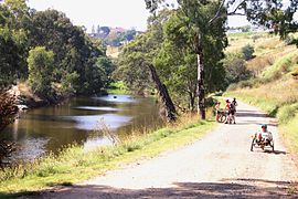
Maribyrnong River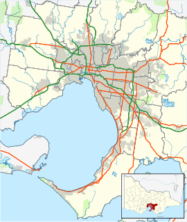
 Maidstone
Population: 6050 (2006)[1] Established: 1840s Postcode: 3012 Area: 3.2 km² (1.2 sq mi) Location: 8 km (5 mi) from Melbourne LGA: City of Maribyrnong State District: Footscray Federal Division: Gellibrand Suburbs around Maidstone: Avondale Heights Maribyrnong Maribyrnong Braybrook Maidstone Maribyrnong Braybrook West Footscray Footscray Maidstone is a suburb 8 km west of Melbourne, Victoria, Australia. Its Local Government Area is the City of Maribyrnong. At the 2006 Census, Maidstone had a population of 6050.
Maidstone is a suburb of the City of Maribyrnong, located 8 km from the Melbourne CBD, bordered by West Footscray to the South on Suffolk Street, Braybrook to the west on Ashley St, Footscray to the east along Summerhill and Rosamond Roads and Maribyrnong to the north and north-east along Williamson Road and Rosamond Road.
Contents
History
Maidstone was established in 1858. It was given the name of the town of Maidstone in Kent as it is close to Footscray which was named after Foots Cray, another town formerly in Kent.
Maidstone Post Office opened on 1 October 1858 and closed in 1986.[2]
Maidstone was predominantly made up of period weatherboard, brick Art Deco and Californian Bungalow houses constructed between the 1920s and 1940s. Concrete houses built in the late 1940s to house the families of returned servicemen from World War II are also found. From the early 1990s many old factory sites in Maidstone have been turned into new housing estates comprising hundreds of houses and townhouses. Maidstones recent development boost, good public transport availability and close proximity to the CBD has also seen the median house price escalate dramatically over the past 10 years.
Attractions
- Highpoint Shopping Centre (est 1975. Technically part of neighboring suburb Maribyrnong, however lies on the border of Maidstone.)
- Maribyrnong River
- Maribyrnong River Trail
- Medway Golf Club
Education
 Footscray North Primary
- Maribyrnong College (est 1958) Located on the border of Maidstone & Maribyrnong. Street Address is River St, Maribyrong after rezoning.
- Footscray North Primary School (est 1922) Located on the border of Maidstone & Footscray (Technically located in Footscray, as the Eastern side of Rosamond Road at that point is Footscray.)
- St Vincents School.
- Little VIPs Childcare Centre.
- Highpoint Kinder Haven - located on the border of Maidstone & Footscray.
Features
- Our Lady's Catholic Church is a landmark building established in 1962 located on Ballarat Road.
- Al-Noor Mosque in Maidstone is the second oldest mosque in Melbourne and one of the oldest in Australia.
- There is a Student Village for the Victoria University in the area.
- Flemington Racecourse (Home of the Melbourne Cup) is located adjacent to Maidstone, just the other side of the Maribyrnong River.
- The Western Highway runs through Maidstone.
- The ongoing development and success of Melbourne Docklands in the West of Melbourne has attracted interest for further development of inner city suburbs such as Footscray and Maidstone.
- The new modern housing estate Edgewater on the Maribyrnong River borders Maidstone.
- Genesis Fitness Club (est 2009) located on cnr of Hamstead Rd and Emu Rd (indoor athletics track)
Sport facilities
Maidstone boasts many sports clubs. The list of clubs include the following;
- Sunshine George Cross Juniors Soccer Club (Dobson Reserve)
- Rosamond Bowling Club
- Leros United Soccer Club (Scovell Reserve)
- Rosamond Tennis Club (Footscray North Primary School)
- Maidstone Junior Sporting Club (As above)
- Footscray United Cricket Club (Scovell Reserve)
Golfers play at the course of the Medway Golf Club on Omar Street.[3]
Transport
Tram route 57 tram provides public transport from Flinders Street Station in the city to Cordite Avenue, West Maribyrnong, on the border of Maidstone, while tram route 82 tram provides public transport from Moonee Ponds (Ascot Vale Road / Puckle Street) to Footscray (Leeds Street / Irving Street) passing through Maidstone for a segment of its journey. It is one of very few Melbourne tram routes which do not travel through the Melbourne CBD.
West Footscray and Tottenham train stations are the closest to Maidstone but many residents catch the bus to Footscray station.
A number of different buses pass through the Maidstone.
The Maribyrnong River Trail connects cyclists to the Footscray Road off-road path and into the Docklands and Melbourne CBD.
Flora and fauna
Many native species exist along the Maribyrnong River. Some species thrive in the area and often journey up and down river from Brimbank Park (5 km up river from Maidstone). The most abundant are;
- Rainbow Lorikeet
- Common Brushtail Possum
- Black Flying Foxes or Fruit Bat Pteropus
- Cockatoo
- Galah
Notable people
- Albert Facey - Author of A Fortunate Life and Gallipoli veteran. Has a street named after him in the eastern part of Maidstone.
See also
- City of Sunshine - the former local government area of which Maidstone was a part.
References
- ^ Australian Bureau of Statistics (25 October 2007). "Maidstone (State Suburb)". 2006 Census QuickStats. http://www.censusdata.abs.gov.au/ABSNavigation/prenav/LocationSearch?collection=Census&period=2006&areacode=SSC21425&producttype=QuickStats&breadcrumb=PL&action=401. Retrieved 2007-09-29.
- ^ Premier Postal History, Post Office List, https://www.premierpostal.com/cgi-bin/wsProd.sh/Viewpocdwrapper.p?SortBy=VIC&country=, retrieved 2008-04-11
- ^ Golf Select, Medway, http://www.golfselect.com.au/armchair/courseView.aspx?course_id=2957, retrieved 2009-05-11
External links
Coordinates: 37°46′59″S 144°52′41″E / 37.783°S 144.878°E
Suburbs of the City of Maribyrnong | Melbourne | Victoria Braybrook · Footscray · Kingsville · Maidstone · Maribyrnong · Seddon · Tottenham · West Footscray · Yarraville
Categories:- Suburbs of Melbourne


Wikimedia Foundation. 2010.