- San Jacinto Peak
-
San Jacinto Peak 
North face of San Jacinto Peak.Elevation 10,834 ft (3,302 m) NAVD 88[1] Prominence 8,319 ft (2,536 m) [2] Parent peak Mount Whitney [3] Listing Ultra [3] HPS list [4] Translation Saint Hyacinth's Peak (Spanish) Location Location Riverside County, California, USA Range San Jacinto Mountains Coordinates 33°48′53″N 116°40′46″W / 33.814712342°N 116.679438022°WCoordinates: 33°48′53″N 116°40′46″W / 33.814712342°N 116.679438022°W[1] Topo map USGS San Jacinto Peak Climbing Easiest route Tramway and trail hike San Jacinto Peak, 10,834 feet (3,302 m), is the highest peak of the San Jacinto Mountains, and of Riverside County, California. It lies within Mount San Jacinto State Park. Naturalist John Muir wrote of San Jacinto Peak, "The view from San Jacinto is the most sublime spectacle to be found anywhere on this earth!"[5]
San Jacinto Peak is one of the most topographically prominent peaks in the United States. It is ranked 6th among peaks in the 48 contiguous states.[3]
Contents
Geography
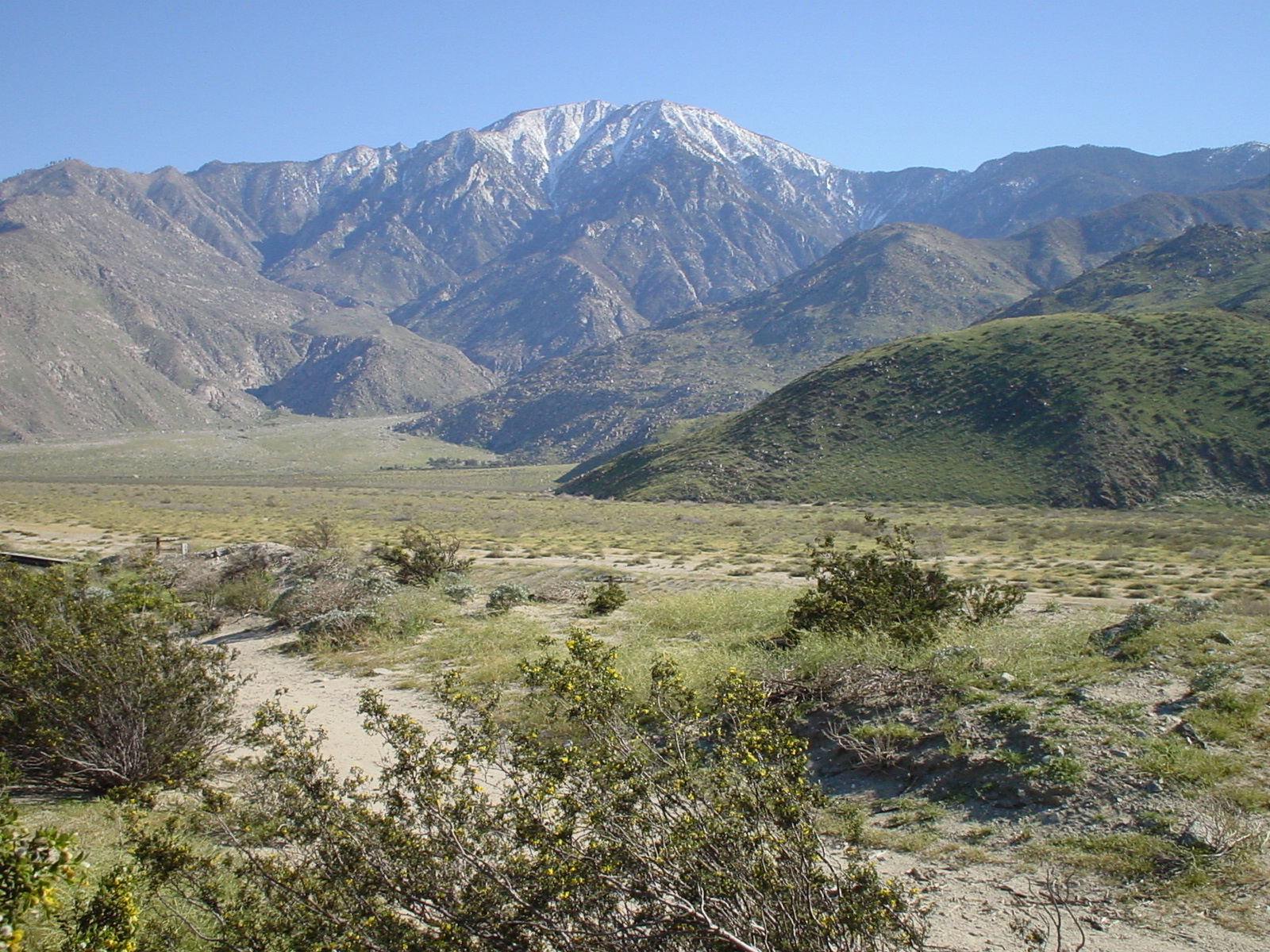
To the east, the peak towers over the city of Palm Springs; to the west, it borders the mountain community of Idyllwild. The peak is also frequently called Mount San Jacinto. The steep escarpment of its north face, above Snow Creek, climbs over 10,000 feet (3,000 m) in 7 miles (11 km). This is one of the largest gains in elevation over such a small horizontal distance in the contiguous United States.
From the peak, San Gorgonio Mountain can be seen across the San Gorgonio Pass. Also easily visible below is the Coachella Valley and the Salton Sea. In addition, much of the Inland Empire, including Ontario to the west, can be viewed on a clear day.
Mount San Jacinto is one of the "Three Saints," a name occasionally used to describe the high points of the three tallest mountain ranges in Southern California: San Jacinto Peak, Mount San Gorgonio (high point of the San Bernardino Mountains), and Mount San Antonio (high point of the San Gabriel Mountains).
History
To the Cahuilla Indians, the peak was known as I a kitch (or Aya Kaich), meaning "smooth cliffs." It was the home of Dakush, the meteor and legendary founder of the Cahuilla.[6]
In 1878, a Wheeler Survey topographical party led by rancher Charles Thomas of Garner Valley climbed the peak. The Wheeler Survey gave the mountain the name "San Jacinto Peak" (rather than "Mt. San Jacinto" or "San Jacinto Mountain.")[7] The earliest recorded ascent of the peak was made in September, 1874 by "F. of Riverside," according to a description of his ascent in the San Diego Union. The first successful ascent of the difficult northeast escarpment was made in 1931 by Floyd Vernoy and Stewart White of Riverside.[8]
The peak is flanked by Jean Peak 10,670 feet (3,250 m) and Marion Mountain (10,362 feet, 3158 meters). These peaks were named in 1897 by USGS topographer Edmund Taylor Perkins, Jr. Perkins named Jean Peak for his sweetheart and future bride, Jean Waters of Plumas County, whom he married in 1903. He named Marion Mountain after Marion Kelly, his girlfriend, a teacher for the Indian Bureau at the Morongo Valley Reservation. According to a local legend, Perkins spent the summer of 1897 deciding which woman to marry while he conducted his topographical survey of San Jacinto Peak and its environs.[8]
Nearby Cornell Peak is named for Cornell University, the alma mater of geologist Robert T. Hill. Perkins and Hill were camping in Round Valley when Hill remarked that the peak looked like the campanile tower at Cornell. Perkins later named the peak Cornell Peak.[8]
In 1931 and 1932, the San Jacinto Mountain Chamber of Commerce sponsored a Labor Day footrace from Idyllwild to San Jacinto Peak and back, a distance of 18 miles and 5,300 feet. The 1931 race was won by Tom Humphreys, a Hopi, in 3:36:30. Humphreys won the race again in 1932 with a time of 3:12.[9] Near the summit of San Jacinto peak is a stone hut that was built in 1935 by the Civilian Conservation Corps.[10]
 San Jacinto Peak, showing its north escarpment, one of the highest in the contiguous United States.
Hiking
San Jacinto Peak is easily accessible, as many trails penetrate the San Jacinto Wilderness. The most popular route starts with a ride on the Palm Springs Aerial Tramway from Valley Station at 2,643 feet (806 m) near Palm Springs up to Mountain Station at 8,516 feet (2,596 m). From there, one can easily climb the mountain face via trails.[11] Another route is to hike the Marion Mountain Trail from near the mountain town of Idyllwild.[12] The Cactus to Clouds trail involves an arduous climb of over 10,000 feet (3,000 m) from the Palm Springs Art Museum to the summit at 10,800 feet (3,300 m).[13]
 Emergency hut near the summit
The mountain is quite rugged in places, with several outdoor hazards that hikers may be unprepared for, including high altitude, severe weather, steep rock faces, and wild animals. Hikers and climbers die or are harmed every year.
Mountaineers can tackle the mountain's steep north face from the town of Snow Creek. This route is a challenging mountaineering route that gains nearly 10,000 feet in less than 7 miles and involves hiking over rough terrain, climbing or scrambling on steep rock and long, sustained snow climbing with crampons and an ice axe. Climbers have been seriously injured or died while attempting this challenging route to the summit.
See also
- List of highest points in California by county
- Mountain peaks of California
- Mountain peaks of North America
- Mountain peaks of the United States
References
- ^ a b "San Jacinto". NGS data sheet. U.S. National Geodetic Survey. http://www.ngs.noaa.gov/cgi-bin/ds_mark.prl?PidBox=DX5119. Retrieved 2008-11-02.
- ^ "San Jacinto Peak, California". Peakbagger.com. http://www.peakbagger.com/peak.aspx?pid=1480. Retrieved 2008-11-02.
- ^ a b c "America's 57 - the Ultras". Peaklist.org. http://www.peaklist.org/USlists/USP5000.html. Retrieved 2009-02-28.
- ^ "San Jacinto Peak". Hundred Peaks Section List. Angeles Chapter, Sierra Club. http://angeles.sierraclub.org/hps/guides/27F.htm. Retrieved 2009-08-17.
- ^ Heald, Weldon F. (July, 1963) "The Lordly San Jacintos," in Westways. The account of Muir visiting Mt. San Jacinto appeared first in Frederick, K. P. (1926) Legends and History of the San Jacinto Mountains. Long Beach, CA.
- ^ Francisco; Margaret Boynton (1943). Los Angeles: Times-Mirror. p. 33. OCLC 4020904.
- ^ Wheeler, George M. (1879). "Appendix OO". Geological Surveys of the Territory of the States West of the 100th Meridian. Washington: Government Printing Office. p. 3103.
- ^ a b c Robinson, John W; Bruce D. Risher (1993). The San Jacintos. Arcadia: Big Santa Anita Historical Society. pp. 45, 192–195. ISBN 0961542160.
- ^ Robinson, John W. and Bruce D. Risher (1993) The San Jacintos. Big Santa Anita Historical Society: Arcadia. p.195.
- ^ "Mt. San Jacinto State Park". California State Parks. http://www.parks.ca.gov/?page_id=25176. Retrieved 2009-08-17.
- ^ "San Jacinto Peak via Palm Springs Tram". LocalHikes. http://www.localhikes.com/Hikes/SanJacintoPeak_4472.asp. Retrieved 2009-08-17.
- ^ "San Jacinto Via Marion Mountain Trail". LocalHikes. http://www.localhikes.com/Hikes/SanJacintoViaMarion_4472.asp. Retrieved 2009-08-17.
- ^ "Cactus to Clouds Hike, Mt. San Jacinto Peak". Yelp. http://www.yelp.com/biz/cactus-to-clouds-hike-mt-san-jacinto-peak-palm-springs. Retrieved 2009-08-17.
External links
- "San Jacinto Peak". Trailguru. http://www.trailguru.com/wiki/index.php?title=San_Jacinto_Peak. Retrieved 2008-11-02.
- "Mount San Jacinto State Park". California State Parks. http://www.parks.ca.gov/default.asp?page_id=636. Retrieved 2009-08-17.
- Mount San Jacinto State Park. Mount San Jacinto State Park map (Map). http://www.parks.ca.gov/pages/636/files/MtSanJacintoSPmap.pdf. Retrieved 2009-08-17.
- "San Jacinto Peak". SummitPost.org. http://www.summitpost.org/page/150673. Retrieved 2011-05-07.
- "Cactus to Clouds Hiking Guide". Mt. San Jacinto Message Board. Archived from the original on 2009-10-25. http://web.archive.org/web/20091025123310/http://geocities.com/cactus2clouds/skyline.html. Retrieved 2009-08-17.
- Riverside Mountain Rescue Unit "Main page". Riverside Mountain Rescue Unit. http://www.rmru.org/ Riverside Mountain Rescue Unit. Retrieved 2009-08-17.
- "Forum Index". Mt. San Jacinto Outdoor Recreation. http://www.mtsanjacinto.info. Retrieved 2009-08-17.
Categories:- Mountains of Riverside County, California


Wikimedia Foundation. 2010.