- Compstall
-
Coordinates: 53°24′51″N 2°03′17″W / 53.4143°N 2.0546°W
Compstall 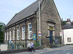
The Athenaeum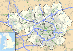
 Compstall
Compstall shown within Greater ManchesterOS grid reference SJ963908 Metropolitan borough Stockport Metropolitan county Greater Manchester Region North West Country England Sovereign state United Kingdom Post town STOCKPORT Postcode district SK6 Dialling code 0161 Police Greater Manchester Fire Greater Manchester Ambulance North West EU Parliament North West England UK Parliament Hazel Grove List of places: UK • England • Greater Manchester Compstall is a suburban village within the Metropolitan Borough of Stockport in Greater Manchester, England, between Marple Bridge and Romiley. It was formerly a mill village, built by George Andrew in the 1820s to house his 800 workers. Most of the original mill cottages and other structures remain unchanged.
The waterways were also constructed by Andrew to carry water from the weir, on the river, to turn the mill wheels, which stood where the car park is today. A water wheel was called "Big Lily" and was the largest wheel in England when it was built in 1839.[1] It is where Etherow Country Park is situated and Compstall .
Contents
History
Compstall was first noted as place where farmers would meet to trade and sell their sheep. The sheep were held at Barlow Fold, Greave Fold, Ratcliffe Fold, Beacom Fold and Lower Fold. In the market place today can be seen the touch stone where deals were made. The touch stone is a glacial erratic deposited during the last ice age. The deal having been agreed, the parties would spit on their hands, and hit the stone, sealing the deal.[2]
In 1804, the Andrew family established a water driven calico printing business downstream from the present mill site.[3] In 1815 Thomas Andrew died, his son George Andrew I reorganised the business. He built a water powered cotton mill, and a reservoir to power the wheels. He had a steam engine to provide backup power. The first two water wheels, Old Josh and North wheel were supplemented by the giant Lily Wheel in 1838. This was 17 ft wide (5.2 m) and 50 ft in diameter (15 m). It was built by Fairburn and Lillie.[1] The earliest workers cottages had been built in the southern side of the bridge in 1806; in 1823 cottages were built along Market street on the north side, and this became the heart of the village. With further mills, further houses were added to the north of the village, and by 1839 the village was almost complete. [3]
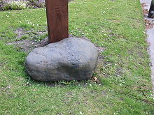 The Touch Stone, a glacial erratic deposited during the last ice age, is where deals were made in the Market Place.
A Co-op store was opened in 1851, further shops followed. The first church was the Wesleyan Methodist Chapel. The Andrews family built the multipurpose Athenaeum in 1865. St Pauls Church of England church was built in the Early English style.[1]
Steam and gas lighting were installed in the mill by 1890, and these were replaced by electicity in 1915.[1]
Compstall Mills
George Andrew experimented with printing then on the death of his father started on the mill complex on the site we know today. Between 1833 and 1833 he built Old Mill, a five storey L-shaped building that fronted on the river and on Market Street. At the north end of the building there was a four storeu building that housed the water wheel. During the six years from 1833 to 1839, the Scotland Mill, the Victoria Mill, Provans Mill and Noah's Ark weaving sheds were built. Two more waterwheels were added: the North wheel and the Lily wheel that was reputed in 1839 to be the largest in England. It was built by Fairburn and Lillie of Manchester and was 50 feet (15 m) in diameter and 19 feet (5.8 m) in width.
 The cottages on Montagu Street were built by George Andrew to house his mill workers.
The North Mill was added between 1839 and 1847 and the mill office was extended. The Albert Mill and a range of riverside buildings including the mechanics shop were extended between 1847 and 1872. Over the next 25 years many extra weaving sheds were added and extended. By 1907 a new engine house had been added.[3]
Other Landmarks
Compstall Hall was built by George Andrew in 1825. It is a unique Grecian Villa house with an imposing driveway and entrance.[4]
Future Developments
 The first calico printing works was opened by Thomas Andrew downstream of the bridge.
After a long period of consultation, planning permission was sought in July 2009 to restore and redevelop the site. It is proposed that there should be 121 residential units and 25,136 square feet (2,335.2 m2) of commercial space. The Victoria and Albert Mills would be refurbished to create 58 apartments. The Engine House would be restored and house the existing Electricity sub-station and provide industrial space. The Boiler house with its traces of the Lily wheel pit would be restored and be used as commercial space. The Scotland Mill would be demolished and replaced with the New Scotland Mill with 32 two bedroom duplex apartments overlooking the Country Park. The building would mirror the length, height and form of the original mill, using complementary materials. New 3 and 4 bedroom terraced family houses would be built along the north bank of the river where the mechanic shop once stood. A new clubhouse for Etherow Country Park Sailing Club would be built on or near the site of the now demolished Noahs Ark shed.[5]
As with any scheme, there would be landscaping, the site would be tidied, parking provided and public open spaces constructed.
Etherow Country Park
Main article: Etherow Country ParkReferences
- ^ a b c d "Conservation Area Appraisal : Compstall". Stockport Metropolitan Borough Council. March 2006. http://www.stockport.gov.uk/2013/2978/8803/9020/12299/compstallapp. Retrieved 5 April 2010.
- ^ An interpretation board on site.
- ^ a b c "Historic Development of Compstall and the mills estate". Ask. 2008. http://www.askaboutcompstall.co.uk/media/yyyyy2.pdf. Retrieved 2009-07-27.
- ^ Compstall Hall Website
- ^ "Ask about Compstall- News July 2009". Ask Life. http://www.askaboutcompstall.co.uk/news.html. Retrieved 2009-07-28.
Categories:- Villages in Greater Manchester
- Towns and villages of the Peak District
- Geography of Stockport


Wikimedia Foundation. 2010.