Sentinel Island Light

Sentinel Island Light

Infobox_Lighthouse


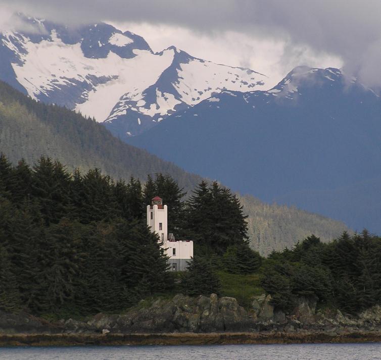
caption = Sentinel Island Light
location = Lynn Canal, Juneau City and Borough, Alaska, USA
coordinates = coord|58|32|46|N|134|55|22|W|region:US_type:landmark
yearlit = 1935
automated = 1966
yeardeactivated =
foundation = Concrete
construction = Wood frame/concrete
shape = Square
height = 51 ft (86 ft above sea level)
lens = Fourth order Fresnel lens
range = 14 nm
characteristic = Flashing white 10s, Obscured from 152° to 296°.
admiralty = G6538
ARLHS = ALK-011
USCG = 6-23850
The Sentinel Island Light is a lighthouse in Alaska adjacent to Lynn Canal in Alaska. It is located at the northern entrance to the Favorite Channel, between the mainland and Lincoln and Shelter Islands. It was officially listed on the National Register of Historic Places on December 2, 2002.

External Links

* [http://www.uscg.mil/history/weblighthouses/LHAK.asp United States Coast Guard Lighthouses of Alaska]
* [http://www.lighthousefriends.com/light.asp?ID=826 Lighthouse Friends — Sentinel Island Lighthouse]
* [http://www.unc.edu/~rowlett/lighthouse/ak.htm Lighthouse Digest — Alaska]


Wikimedia Foundation. 2010.

Игры ⚽ Нужен реферат?

Look at other dictionaries:

  • Sentinel Island — could refer to:* Sentinel Island (Tasmania), Australia * Sentinel Islands, Andaman Islands, India ** North Sentinel Island ** South Sentinel Island * Sentinel Island Light, lighthouse in Alaska, USA * Sentinel Island (Washington), one of the San… …   Wikipedia

  • Mary Island Light — in 1937 Location Mary Island, Revillagigedo Channel, Alaska Coordinates …   Wikipedia

  • Round Island Light (Michigan) — Round Island Light Location Mackinac County, Michigan Coordinates …   Wikipedia

  • Island Princess (steamboat) — Daily (upper) Island Princess (lower) Career …   Wikipedia

  • Boon Island — is a barren piece of land located in the Gulf of Maine 6.2 miles (10 km) off the town of York on the Maine coast. The island is approximately 300 by 700 feet (90 by 213 km) in size, and is the site of Boon Island Light, the tallest lighthouse in… …   Wikipedia

  • Heard Island and McDonald Islands — Heard Island Nickname: HIMI Satellite image of the southern tip of Heard Island. Cape Arkona is seen on the left side of the image, with Lied Glacier just above and Gotley Glacier just below. Big Ben Volcano and Mawson Peak are seen at the lower… …   Wikipedia

  • Warrior Rock Light — Infobox Lighthouse caption = Warrior Rock Light in 2008 location = Sauvie Island, Oregon, U.S. coordinates = coord|45.84858| 122.78835|display=title,inline|region:US OR type:landmark yearlit = 1877/1889/1930/1970s automated = 1930 yeardeactivated …   Wikipedia

  • Northern Light (sternwheeler) — Northern Light at a pier. Career Name: Northern Light …   Wikipedia

  • Battle of Roanoke Island — Infobox Military Conflict conflict=Battle of Roanoke Island partof=the American Civil War color scheme=background:#ffcccc caption= Capture of Roanoke Island, Feby. 8th 1862 , by Currier and Ives date=February 7 ndash; February 8, 1862… …   Wikipedia

  • Makapuu Point Light — (USCG) undated archival photograph (note the men in the picture) Location southeast point of Oahu Coordinates …   Wikipedia

Share the article and excerpts

Direct link
Do a right-click on the link above
and select “Copy Link”