- Flinders Island
Infobox Islands
name = Flinders Island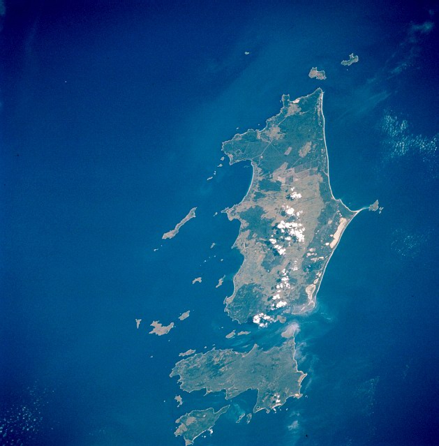
image caption =Furneaux Group from space, April 1993
locator
native name =
native name link =
location =Tasmania
coordinates= coord|40|00|S|148|07|E|type:isle_region:AU-TAS
area = 1,333 km² (515 sq mi)
highest mount =Mount Strzelecki
elevation = 756 m (2,480 ft)
country = Australia
country admin divisions title = State
country admin divisions = flag|Tasmania
country admin divisions title 1 = LGA
country admin divisions 1 = Municipality of Flinders Island
country largest city = Whitemark
country largest city population = population 170
population = 897
population as of = 2005
density = (1.742/sq mi) 0.673
ethnic groups =Flinders Island is an island in the
Bass Strait , located 20 km fromCape Portland being the north-eastern tip ofTasmania ,Australia . It is the largest island in theFurneaux Group .History
The Furneaux Group was first discovered by Europeans in 1773 when it was sighted by
Tobias Furneaux , a support ship commander of Captain Cook's party. In 1798-'99 British explorersMatthew Flinders andGeorge Bass completed the first ever circumnavigation of Tasmania, proving it to be an island separate from the Australian mainland.Bass Strait was named in honour of George Bass, whereas the main island in the Furneaux Group was named after Flinders. In the late 1700s, the island was settled by sealers and their mostly Aboriginal wives, but seal stocks soon collapsed, causing the last sealing permit to be issued in 1828. Many sealers' families chose to stay in the Furneaux Group, subsisting on cattle grazing andmuttonbirding .
In 1833, the remnants of the Tasmanian Aboriginal population were exiled to Settlement Point (or "Wybalenna", meaning Black Man's House) on Flinders Island. These 160 survivors were deemed to be safe from white settlers here, but the relocation scheme was short-lived and doomed to fail. In 1847 the remaining 45 Aboriginals were again relocated, this time to Oyster Cove on Tasmania's east coast.
From the late19th Century freehold land was given out, but it was not until the 1950s that a proper settlement scheme was initiated, mainly drawing settlers from mainland Tasmania and centralNew South Wales to Flinders Island's eastern shore. The Municipality of Flinders Island was instituted in 1903 [http://www.focusonflinders.com.au/about.htm Focus on Flinders website] ] .Geography and Nature
The island forms part of the state of Tasmania, and part of the Municipality of Flinders Island local government area. Note that Flinders Island is only one of the many islands included in the Municipal area, although Flinders Island itself is the only island with more than one permanent settlement and by far the largest in the Furneaux Group.
The island is approximately 62 km from north to south, and 37 km from east to west [Google Earth measurements] . The island's total land area is 1333 km². With a height of 756 m,
Mount Strzelecki in the south west is the island's highest peak. About a third of the island is mountainous and rugged with ridges ofgranite running the length of the island. The coastal areas are dominated by sandy deposits often taking the shape ofdune s. Many coastallagoon s punctuate the eastern shore, formed by dunes blocking further drainage. Thisdrainage is mainly provided by many small streams, few of them permanently flowing, directly leading to the waters of Bass Strait or such a lagoon.
The coastal areas are mainly covered in scrub orshrub s, whereas the vegetation at a higher elevation consists of woodland, mainlyeucalyptus species. The total number of plant species in the Furneaux Group well exceeds 800, showing the greatbiodiversity of itsecosystem [http://www.focusonflinders.com.au/about.htm Focus on Flinders website] ] . Animal species includeBennett's Wallaby ("Macropus rufogriseus"),Brushtail Possum ("Trichosurus vulpecula"),Cape Barren Goose ("Cereopsis novaehollandiae"),Short-tailed Shearwater ("Puffinus tenuirostris"),Eastern Pygmy Possum ("Cercartetus nanus"),Potoroo ("Potorous apicalis"),Common Ringtail Possum ("Pseudocheirus peregrinus"),Tasmanian Pademelon ("Thylogale billardierii"), andCape Fur Seal ("Arctocephalus pusillus") [ [http://focusonflinders.com.au/florafauna.htm Focus on Flinders fauna page] ] . The area surroundingMount Strzelecki in the south west of the island constitutesStrzelecki National Park .Demographics
The population in
2005 was 897 people; the median age being 45. [ [http://www.abs.gov.au/ausstats/abs@.nsf/Latestproducts/3218.0Main%20Features72004-05?opendocument&tabname=Summary&prodno=3218.0&issue=2004-05&num=&view= Australian Bureau of Statistics] ]Settlements include Whitemark (which has the island's main airstrip and about 170 inhabitants (2005) and Lady Barron (approx. 130 inhabitants), Blue Rocks, Emita, Killiecrankie, Lackrana, Leeka, Loccota, Lughrata, Memana, Palana, Ranga, Wingaroo, and Wybalenna [Hema Road Map of Tasmania, Hema Maps, 1990, ISBN 0 670 90403 1] [ [http://www.arta.com.au/tasmaps/flinders_island.html Wilkins Tourist Maps' online map of the Furneaux Group] ] (all below Lady Barron's population figure).
Communications
Airlines of Tasmania runs a daily service fromLaunceston, Tasmania (40 minutes) and a three-weekly flight from Melbourne-Essendon (90 minutes) [ [http://focusonflinders.com.au/Airtas.htm Focus on Flinders Airlines of Tasmania page] ] . Both services terminate atFlinders Island Airport about 3 km north of Whitemark.Climate
Infobox Weather
metric_first=yes
single_line=yes
location =Flinders Island Airport
Jan_Hi_°C =22.0
Feb_Hi_°C =22.6
Mar_Hi_°C =21.2
Apr_Hi_°C =18.7
May_Hi_°C =16.2
Jun_Hi_°C =14.0
Jul_Hi_°C =13.3
Aug_Hi_°C =13.7
Sep_Hi_°C =15.0
Oct_Hi_°C =16.7
Nov_Hi_°C =18.4
Dec_Hi_°C =20.1
Year_Hi_°C =17.7
Jan_Lo_°C =13.3
Feb_Lo_°C =13.6
Mar_Lo_°C =12.5
Apr_Lo_°C =10.7
May_Lo_°C =9.0
Jun_Lo_°C =7.0
Jul_Lo_°C =6.3
Aug_Lo_°C =6.6
Sep_Lo_°C =7.5
Oct_Lo_°C =8.5
Nov_Lo_°C =10.1
Dec_Lo_°C =11.8
Year_Lo_°C =9.7
Jan_Precip_mm =46.2
Feb_Precip_mm =38.8
Mar_Precip_mm =49.8
Apr_Precip_mm =59.2
May_Precip_mm =80.4
Jun_Precip_mm =71.8
Jul_Precip_mm =84.8
Aug_Precip_mm =74.5
Sep_Precip_mm =63.7
Oct_Precip_mm =61.5
Nov_Precip_mm =54.4
Dec_Precip_mm =56.8
Year_Precip_mm =742.4
source =Bureau of Meteorologycite web
url=http://www.bom.gov.au/climate/averages/tables/cw_099005.shtml|title=Climate Data|accessmonthday=August 2 |accessyear=2008
publisher=BoM|language=]
accessdate =1962-2008References
Wikimedia Foundation. 2010.