- Marsh Farm
-
Not to be confused with Marsh Farm Junction or Inner Marsh Farm.
Coordinates: 51°55′01″N 0°27′11″W / 51.9169°N 0.453°W
Marsh Farm 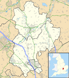
 Marsh Farm
Marsh Farm shown within BedfordshirePopulation 10,000 (est.) OS grid reference TL0523 Unitary authority Luton Ceremonial county Bedfordshire Region East Country England Sovereign state United Kingdom Post town LUTON Postcode district LU3 Dialling code 01582 Police Bedfordshire Fire Bedfordshire and Luton Ambulance East of England EU Parliament East of England UK Parliament Luton North List of places: UK • England • Bedfordshire Marsh Farm is a large housing estate in Luton, Bedfordshire near to Leagrave and Limbury, mainly of council and social housing.
The estate was built in the late 1960s, with a mixture of flats and houses as part of the post-war expansion of Luton. The estates at Farley Hill, Hockwell Ring and Stopsley were all built at about the same time. The council owned tower blocks that dominate the estate are called Lea Bank, Penhill and Five Springs, each is of a similar design and are 15 floors each reaching a total height of 44.20m. (145.0 feet)
The estate takes its name from the farm that owned much of the land that eventually became the estate. Marsh Farm was located by Leagrave Marsh and part of the old farmland is now Leagrave Park.
There are several schools and there is a leisure centre as well as a few popular play areas.
The estate was infamous in July 1995 when the social problems on the estate boiled over into three days of rioting. Although local police received the help of the Metropolitan Police riot squad to bring the situation under control, [1] it was the rave organisers Exodus Collective who brought the riots to an end by staging an impromptu party out of town which drew 1500 young people from the area and calmed them down.[2] The 1995 riots followed similar riots in the area in 1992.
Whilst many parts of the estate still look like a typical 1960s development, the estate has £50m of European money available for re-development and plans are being drawn up by the local council and other interested parties.
In the summer of 1999 some regeneration money was used to fund murals on the underpasses around the estate. The lead artist, Viv McIntyre, visited each school on the estate and carried out workshops with the pupils where they provided the images (based on given themes) to create the mural designs. A team of artists, including Emma Rhodes and Margaret Rhodes (artist), then worked with the children to transfer the designs from paper to the walls.
Contents
Purley Centre
The Purley Centre is the main focal point in Marsh Farm. The centre is a council-owned shopping centre with another multi-story block of flats above. There is a newsagent, a bakery, a butcher, a library, a pharmacy, a convenience store and many other things in the shopping centre. There is a pub outside the centre, The Purley tavern, and a market is held every Thursday & Saturday.
Transport
Marsh Farm is well connected by bus with regular services to Luton Town Centre. The estate benefits from the M1 as well connections to the A6. Luton Airport is within 3 miles.
Leagrave railway station is a 20 minute walk from Marsh Farm and there are frequent trains to Luton, St Albans, Bedford, London and Brighton.
Local schools and education
- Sundon Park Junior School, Kinross Crescent
- Waulud Primary School, Wauluds Bank Drive
- Woodlands Secondary School, Northwell Drive
- Lealands High School, Sundon Park Road
- Lea Manor High School and community college Northwell Drive
- Leagrave Library, Marsh Road
- Marsh Farm Library, Purley Centre
- Whitefields Infant School
- Whitefield Junior School
Religion
The estate lies within the ecclesiastical benefice of The Holy Cross, Marsh Farm and is served by the Parish Church of the Holy Cross (Church of England) built in 1976 and located in the centre of the estate adjacent to the medical centre on Purway Close. The Parish is registered with Forward in Faith and is Anglo-Catholic in its theology and worship. The Roman Catholic Church of The Holy Family is located off Northwell Drive and is one of the largest parishes in the Diocese of Northampton. During the season of Lent both Churches join together in the Stations of the Cross.[citation needed][3]
Politics
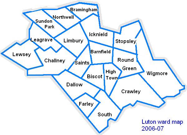
Marsh Farm falls into the Northwell ward is represented by Cllr Roy Davis (Labour) and Cllr Don Worlding (Labour).
The ward forms part of the parliamentary constituency of Luton North, and the MP is Kelvin Hopkins (Labour). Leagrave is within the East of England (European Parliament constituency).
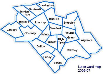 Map of Luton showing Northwell ward
Local attractions
Key 
Abbey/Priory/Cathedral 
Accessible open space 
Amusement/Theme Park 
Castle 
Country Park 
English Heritage 
Forestry Commission 
Heritage railway 
Historic House 

Museum (free/not free) 
National Trust 
Zoo  Dunstable Downs
 Chiltern Hills
- Leagrave Park
- Leighton Buzzard Light Railway
 Luton Museum & Art Gallery
- the hat Factory
 Luton Hoo
- Mossman Collection
- The Purley Centre
- Someries castle
- Stockwood Craft Museum
- Stockwood Park
- Wardown Park
- Waulud's Bank
- Whipsnade Tree Cathedral
 Whipsnade Wildlife Park
- Woodside Farm and Wildfowl Park
- Wrest Park Gardens
Local newspapers
Two weekly newspapers are delivered free to all the houses in the area. However they are not specific to Marsh Farm. They are:
- Herald and Post - Delivered every Thursday
- Luton Express- Delivered every Wednesday
Marsh Farm in the media
References
External links
The Town of Luton in Bedfordshire, England Places within Luton Barnfield · Biscot · Bramingham · Bury Park · Bushmead · Butterfield Green · Capability Green · Challney · Crawley Green · Farley Hill · Dallow · High Town · Hockwell Ring · Icknield · Leagrave · Lewsey · Limbury-cum-Biscot · Marsh Farm · New Town · Northwell · Putteridge · Round Green · Saints · South ward · Stopsley · Sundon Park · Warden Hills · Wigmore
Amenities Kenilworth Road · Luton Museum · The Mall (Luton) · Stockwood Park · Wardown Park · Waulud's Bank
Education Ashcroft High School · Barnfield College · Barnfield South Academy · Barnfield West Academy · University of Bedfordshire · Cardinal Newman · Challney High School For Boys · Challney High School For Girls · Denbigh High School · Icknield High School · Lea Manor High School · Lealands High School · Luton Sixth Form College · Putteridge High School · Rabia School · Stopsley High School · Woodlands Secondary School
Media Categories:

Wikimedia Foundation. 2010.