- County Tyrone
-
"Tyrone" redirects here. For other uses, see Tyrone (disambiguation).
County Tyrone
Contae Thír Eoghain
Coontie Tyrone
Coat of armsMotto: Consilio et Prudentia (Latin)
"By Wisdom and Prudence"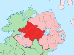
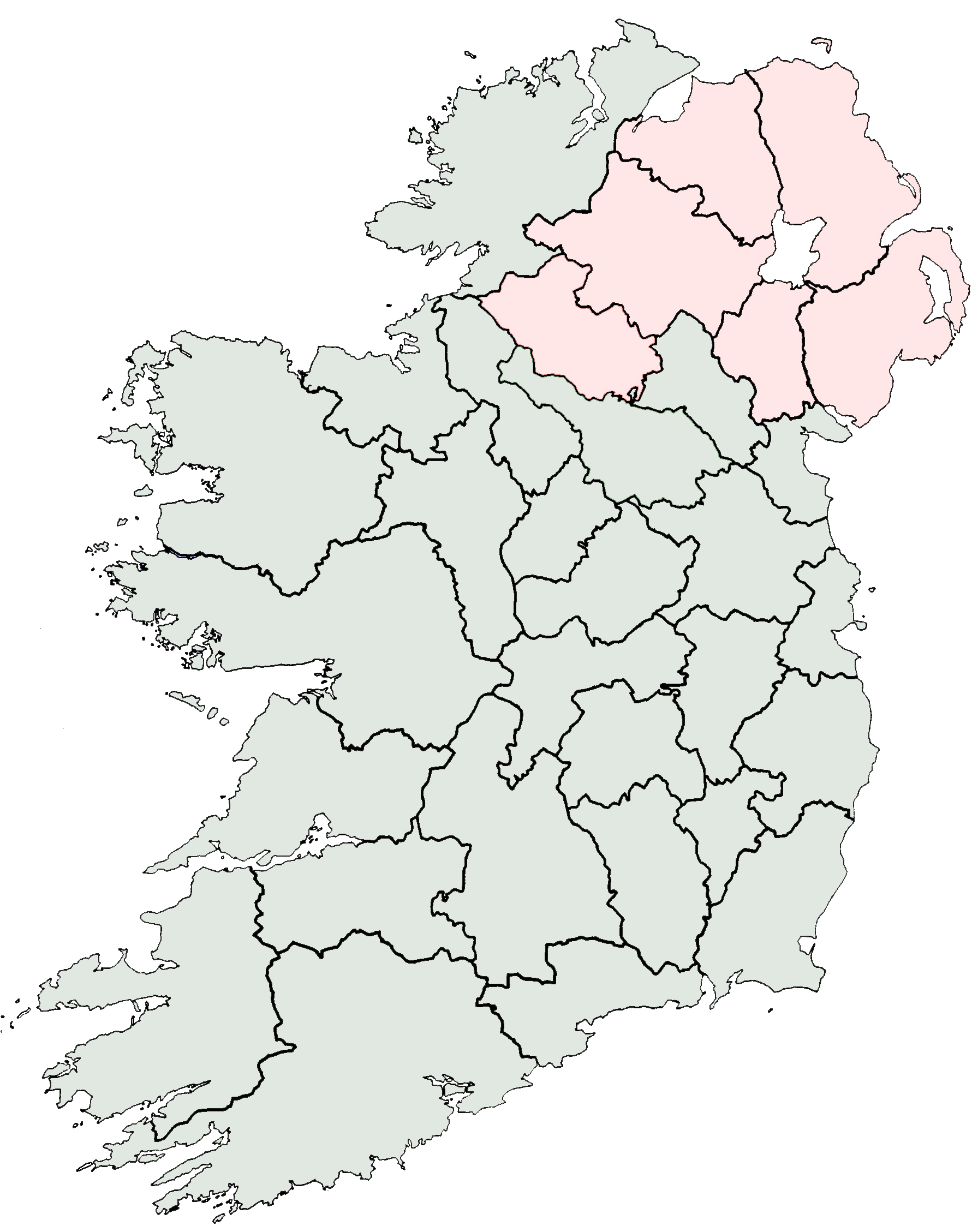
Country United Kingdom Region Northern Ireland Province Ulster County seat Omagh Area - Total 1,259.9 sq mi (3,263 km2) Area rank 8th Population (2001) 166,516 - Rank 10th [1] Contae Thír Eoghain is the Irish name; Countie Tyrone,[2] Coontie Tyrone[3] and Coontie Owenslann[4] are Ulster Scots spellings (the latter used only by Dungannon & South Tyrone Borough Council). County Tyrone (from Irish: Tír Eoghain, meaning "land of Eoghan") is one of the six counties of Northern Ireland. Adjoined to the south-west shore of Lough Neagh, the county covers an area of 3,155 km², with a population of approximately 166,516, with its county town being Omagh. It is also one of the thirty-two traditional counties of Ireland, lying within the historical province of Ulster.
Tyrone is the seventh largest of Ireland’s thirty-two counties in area and eighth largest in terms of population.[5] It is the second largest of Ulster’s nine counties in size and fourth largest in terms of population.[6]
Contents
Name
The name Tyrone is derived from Irish: Tír Eoghain meaning "land of Eoghan". This Eoghan was son of king Niall of the Nine Hostages, and brother of Conall Gulban, who gave his name to the kingdom of Tír Chonaill.[7] Historically, it was anglicised as Tirowen or Tyrowen, which are closer to the Irish pronunciation.
History
Main article: List of Kings of Tír EógainHistorical populations Year Pop. ±% 1659 4,088 — 1821 261,865 +6305.7% 1831 304,468 +16.3% 1841 312,956 +2.8% 1851 255,661 −18.3% 1861 238,500 −6.7% 1871 215,766 −9.5% 1881 197,719 −8.4% 1891 171,401 −13.3% 1901 150,567 −12.2% 1911 142,665 −5.2% 1926 132,792 −6.9% 1937 127,586 −3.9% 1951 132,082 +3.5% 1961 133,919 +1.4% 1966 136,040 +1.6% 1971 139,073 +2.2% 1981 150,729 +8.4% 1991 156,284 +3.7% 2001 164,235 +5.1% [8][9][10][11][12][13] Historically Tyrone stretched as far north as Lough Foyle, and comprised part of modern day County Londonderry east of the River Foyle. The majority of County Londonderry was carved out of Tyrone between 1610-1620 when that land went to the Guilds of London to set up profit making schemes based on natural resources located there. Tyrone was the traditional stronghold of the various O'Neill clans and families, the strongest of the Gaelic Irish families in Ulster, surviving into the seventeenth century. The ancient principality of Tír Eoghain, the inheritance of the O'Neills, included the whole of the present counties of Tyrone and Londonderry, and the four baronies of West Inishowen, East Inishowen, Raphoe North and Raphoe South in County Donegal.[7]
Geography
With an area of 3,155 square kilometres (1,218 sq mi), Tyrone is the largest county in Northern Ireland. The flat peatlands of East Tyrone borders the shoreline of the largest lake in Ireland, Lough Neagh, rising gradually across to the more mountainous terrain in the west of the county, the area surrounding the Sperrin Mountains, the highest point being Sawel Mountain at a height of 678 m (2,224 ft). The length of the county, from the mouth of the River Blackwater at Lough Neagh to the western point near Carrickaduff hill is 55 miles (89 km). The breadth, from the southern corner, southeast of Fivemiletown, to the northeastern corner near Meenard Mountain is 37.5 miles (60.4 km); giving an area of 1,260 square miles (in 1900).[7] Annaghone lays claim to be the geographical centre of Northern Ireland.
Demography
It is one of four counties in Northern Ireland which presently has a majority of the population from a Catholic community background, according to the 2001 census. In 1900 County Tyrone had a population of 197,719,[7] while in 2001 it was 166,516.
Settlements
Main article: List of places in County TyroneLarge towns
(population of 18,000 or more and under 75,000 at 2001 Census)[14]
Medium towns
(population of 10,000 or more and under 18,000 at 2001 Census)[14]
Small towns
(population of 4,500 or more and under 10,000 at 2001 Census)[14]
Intermediate settlements
(population of 2,250 or more and under 4,500 at 2001 Census)[14]
Villages
(population of 1,000 or more and under 2,250 at 2001 Census)[14]
Small villages or hamlets
(population of less than 1,000 at 2001 Census)[14]
- Altamuskin
- Altmore
- Ardstraw
- Artigarvan
- Augher
- Aughnacloy
- Ballygawley
- Ballymagorry
- Beragh
- Caledon
- Clogher
- Clonoe
- Derrylaughan
- Derrytresk
- Donaghmore
- Donemana
- Drumquin
- Edenderry
- Eglish
- Erganagh
- Eskra
- Evish
- Glenmornan
- Gortin
- Greencastle
- Killyclogher
- Loughmacrory
- Kildress
- Pomeroy
- Rock
- Stewartstown
- Tullyhogue
- Victoria Bridge
Subdivisions
Baronies
Main article: Baronies of Ireland- Clogher
- Dungannon Lower
- Dungannon Middle
- Dungannon Upper
- Omagh East
- Omagh West
- Strabane Lower
- Strabane Upper
Parishes
Main article: List of civil parishes of County TyroneTownlands
Main article: List of townlands in County TyroneSport
The major sports in Tyrone are Gaelic games, Association football and Rugby Union.[citation needed]
- Gaelic football is more widely played than hurling. The Tyrone GAA football side has had considerable success since 2000, winning three All Ireland titles (in 2003, 2005 and 2008), they have also won thirteen Ulster titles (1956, 1957, 1973, 1984, 1986, 1989, 1995, 1996, 2001, 2003, 2007, 2009, 2010)[15] and two National League titles (in 2002 and 2003).[citation needed]
- Underage Gaelic football teams have also had considerable successes on the field at both provincial and national level - winning the All-Ireland Minor Football Championship seven times (the most recent, also in 2010) and the All-Ireland Under-21 Football Championship four times.[citation needed]
- Association Football also has a large following. Omagh Town F.C. were members of the Irish Football League until they folded in 2005. Dungannon Swifts F.C. compete in the IFA Premiership. Other teams include Irish League Division One side Coagh United F.C. and Division Two sides Dergview F.C. and Killymoon Rangers F.C..
- Rugby Union is very popular in the county. Dungannon RFC are one of only three Ulster teams currently playing in All Ireland League One. Other teams include Omagh RFC, Clogher Valley RFC, Cookstown RFC and Strabane RFC.
People
Notable residents of County Tyrone have included:
- Hugh Ó Neill, 2nd Earl of Tyrone (Aodh Mór Ó Néill), 1540–1617, Irish leader during the Nine Years' War
- Philomena Begley, Irish country music singer
- Tom Clarke, a leader of the 1916 Easter Rising
- John Dunlap (1747–1812), publisher of the first American daily newspaper the Pennsylvania Packet in 1784, also the printer of the American Declaration of Independence.
- Janet Devlin, soul and pop artist and contestant on the Xfactor
- John Hughes, (1797–1864), born in Annaloghan, first Archbishop of Roman Catholic diocese of New York.[16]
- Peter Canavan, former All Ireland winning Tyrone captain and second top scorer in Senior Ulster Championship football.
- Darren Clarke, professional golfer.
- Paul Brady, musician.
- Brian Dooher, current captain of the Tyrone senior football team.
- Hugo Duncan, singer and broadcaster on BBC Radio.
- Dennis Taylor, former World Snooker Champion.
- Aaron Hughes, current captain of the Northern Ireland football team and also plays for Fulham.
- Benedict Kiely (1919–2007), writer and broadcaster
- Thomas Mellon, founder of Mellon Bank, now Bank of New York Mellon
- Flann O'Brien, 1911–1966, writer
- Victor Sloan MBE, Visual Artist
- William Burke, 1792–1829, grave robber and murderer
- William Carleton, 1794–1869, writer
- Brian Friel, dramatist and theatre director
- Chloe Coyle, The All Ireland Talent Show (series 2)[17]
- Ivan Sproule, football player for Bristol City F.C.
See also
- Abbeys and priories in Northern Ireland (County Tyrone)
- High Sheriff of Tyrone
- List of civil parishes of County Tyrone
- List of places in County Tyrone
- List of townlands in County Tyrone
- Lord Lieutenant of Tyrone
References
- ^ Cookstown.gov.uk
- ^ North-South Ministerial Council: 2010 Annual Report in Ulster Scots
- ^ North-South Ministerial Council: 2006 Annual Report in Ulster Scots
- ^ Dungannon and South Tyrone Borough Council
- ^ Corry, Eoghan (2005). The GAA Book of Lists. Hodder Headline Ireland. pp. 186–191. ISBN 0340896957.
- ^ Marie Veronica Tarpey The role of Joseph McGarrity in the struggle for Irish independence
- ^ a b c d "Description of County Tyrone from Atlas and Cyclopedia of Ireland (1900)". Library Ireland. http://www.libraryireland.com/Atlas/Tyrone.php. Retrieved 24 February 2009.
- ^ For 1653 and 1659 figures from Civil Survey Census of those years, Paper of Mr Hardinge to Royal Irish Academy March 14, 1865.
- ^ Census for post 1821 figures.
- ^ Histpop.org
- ^ Nisranews.gov.uk
- ^ Lee, JJ (1981). "On the accuracy of the Pre-famine Irish censuses". In Goldstrom, J. M.; Clarkson, L. A.. Irish Population, Economy, and Society: Essays in Honour of the Late K. H. Connell. Oxford, England: Clarendon Press.
- ^ Mokyr, Joel; O Grada, Cormac (November). "New Developments in Irish Population History, 1700-1850". The Economic History Review 37 (4): 473–488. doi:10.1111/j.1468-0289.1984.tb00344.x. http://www3.interscience.wiley.com/journal/120035880/abstract
- ^ a b c d e f "Statistical classification of settlements". NI Neighbourhood Information Service. http://www.ninis.nisra.gov.uk/mapxtreme_towns/statistical%20classification.htm. Retrieved 23 February 2009.
- ^ The Tyrone GAA team have won the Ulster Senior Championship on eight occasions in the 20th century
- ^ Who Was Who in America, Historical Volume, 1607-1896. Chicago: Marquis Who's Who. 1963.
- ^ Belfast Telegraph - Chloe Coyle
- The Memoirs of John M. Regan, a Catholic Officer in the RIC and RUC, 1909–48, Joost Augusteijn, editor, District Inspector, Co. Tyrone, 1920s, ISBN 978-1-84682-069-4.
Further reading
- McNeill, I. 2010. The Flora of County Tyrone. National Museums of Northern Ireland. ISBN 978-905989-17-1
External links
- County Tyrone at the Open Directory Project
- A Flavour of Tyrone
- County Tyrone.com
- Ulster-American Folk Park
Counties and cities of Northern Ireland Counties Antrim · Armagh · Down · Fermanagh · Londonderry · Tyrone
Cities Counties of Ireland The counties are listed per provinceConnacht 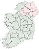
Munster Clare · Cork (Cork City) · Kerry · Limerick (Limerick City) · Tipperary (North Tipperary • South Tipperary) · Waterford (Waterford City)
Leinster Ulster Italics denote non-administrative counties. Brackets denote eponymous cities or non-traditional counties. † denotes counties of Northern Ireland


Wikimedia Foundation. 2010.