Zumalai

Zumalai
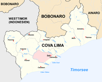
Location of Zumalai city in the east of Cova-Lima district.

Zumalai is a city and subdistrict (former Mape-Zumalai) in East Timor. It is part of Cova Lima District since 2003. Before, it was in Ainaro District.

Coordinates: 9°09′S 125°27′E / 9.15°S 125.45°E / -9.15; 125.45


Wikimedia Foundation. 2010.

Игры ⚽ Поможем решить контрольную работу

Look at other dictionaries:

  • Zumalai — Subdistrikt Zumalai …   Deutsch Wikipedia

  • Mape-Zumalai — Subdistrikt Mape Zumalai DMS …   Deutsch Wikipedia

  • Lepo (Zumalai) — Suco Lepo Daten Fläche 5,15 km²[1] Einwohnerzahl 1.174 (2010) …   Deutsch Wikipedia

  • Lour (Zumalai) — Suco Lour Daten Fläche 25,85 km²[1] Einwohnerzahl 360 (2010) …   Deutsch Wikipedia

  • Zulo — Suco Zulo Daten Fläche 38,70 km²[1] Einwohnerzahl 1.700 …   Deutsch Wikipedia

  • Cova Lima — Distrikt von Cova Lima Daten Hauptstadt …   Deutsch Wikipedia

  • Beco I — DMS …   Deutsch Wikipedia

  • Beco II — DMS …   Deutsch Wikipedia

  • Tashilin — Suco Tashilin Daten Fläche 59,67 km²[1] Einwohnerzahl 2.568 …   Deutsch Wikipedia

  • Liste der Orte im Distrikt Cova Lima —  Karte mit allen Koordinaten: OSM, Google oder …   Deutsch Wikipedia

Share the article and excerpts

Direct link
Do a right-click on the link above
and select “Copy Link”