- Portlethen Village
-
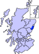
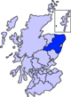
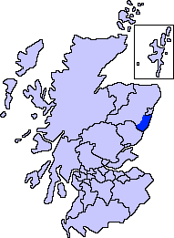
Portlethen Village is a settlement along the North Sea coast in Aberdeenshire, Scotland.[1] The village is also known as Old Portlethen. The skerry of Craigmaroinn is situated just off the coastline near Portlethen Village.
History
Portlethen Village is situated slightly to the east of the ancient Causey Mounth trackway, which road was constructed to make passable this only available medieval route from coastal points south from Stonehaven north to Aberdeen. This ancient trackway specifically connected the River Dee crossing (where the present Bridge of Dee is situated) via Portlethen Moss, Muchalls Castle and Stonehaven to the south.[2] The route was that taken by William Keith, 7th Earl Marischal and the Marquess of Montrose when they led a Covenanter army of 9000 men in the battle of the Civil War in 1639.[3]
For centuries prior to the collapse of local marine fisheries in the 1900s, Portlethen Village derived its livelihood from use of small ocean going wooden boats in pursuit of North Sea fish. It also has a small public house called The Neuk.
See also
Footnotes
- ^ United Kingdom Ordnance Survey Map Landranger 45, Stonehaven and Banchory, 1:50,000 scale, 2004
- ^ C.Michael Hogan, Causey Mounth, Megalithic Portal, ed. by A. Burnham, Nov 3, 2007
- ^ Watt, Archibald, Highways and Byways around Kincardine, Stonehaven Heritage Society (1985)
Settlements and places of interest in Kincardine and Mearns, Aberdeenshire Primary settlements Auchenblae · Drumoak · Fettercairn · Gourdon · Inverbervie · Johnshaven · Laurencekirk · Newtonhill · Portlethen · St Cyrus · Stonehaven
Other settlements Arbuthnott · Banchory-Devenick · Bridge of Muchalls · Cammachmore · Catterline · Cookney · Downies · Drumlithie · Findon · Fordoun · Glenbervie · Kinneff · Kirkton of Durris · Maryculter · Marykirk · Muchalls · Netherley · Portlethen Village
Places of interest Causey Mounth · Crawton · Drum Castle · Dunnottar Castle · Fetteresso Castle · Fowlsheugh Nature Reserve (Craiglethy) · Monboddo House · Muchalls Castle · Normandykes · Portlethen Moss · Raedykes · Stonehaven Open Air Pool · Stonehaven Tolbooth
Areas and primary settlements in Aberdeenshire
(see also: Aberdeen City)in Banff and Buchan Aberchirder · Banff · Fraserburgh · Gardenstown · Inverallochy and Cairnbulg · Macduff · Portsoy · Rosehearty · Sandhaven · Whitehills
in Buchan Boddam · Crimond · Cruden Bay · Fetterangus · Hatton · Longside · Maud · Mintlaw · New Deer · New Pitsligo · Peterhead · St Combs · St Fergus · Strichen · Stuartfield
in Formartine Balmedie · Cuminestown · Ellon · Fyvie · Newburgh · Oldmeldrum · Pitmedden · Potterton · Rothienorman · Tarves · Turriff
in Garioch in Kincardine and Mearns Drumoak · Fettercairn · Gourdon · Inverbervie · Johnshaven · Laurencekirk · Newtonhill · Portlethen · St Cyrus · Stonehaven
in Marr Categories:- Aberdeenshire stubs
- Villages in Aberdeenshire

Wikimedia Foundation. 2010.