- Metropolitan Borough of Bolton
-
For the main settlement, see Bolton.
Metropolitan Borough of Bolton — Metropolitan borough — Bolton Town Hall, the seat of Bolton's borough council

Coat of Arms of the Metropolitan Borough CouncilMotto: "Supera Moras"
(Latin: "Overcome delays")Bolton shown within England
Coordinates: 53°34′53″N 2°25′47″W / 53.58139°N 2.42972°W Sovereign state United Kingdom Constituent country England Region North West England Ceremonial county Greater Manchester Admin HQ Bolton Town Hall Founded 1 April 1974 Borough status Government - Type Metropolitan borough - Governing body Bolton Metropolitan Borough Council - Mayor: Cllr. John Byrne (L) - Leadership: Leader & Cabinet - Leader: Cllr. Cliff Morris (L) - MPs: David Crausby (L)
Yasmin Qureshi (L)
Julie Hilling (L)Area - Total 54 sq mi (139.80 km2) Population (2010 est.) - Total 266,500 (Ranked 39th) - Density 4,861.4/sq mi (1,877/km2) Time zone Greenwich Mean Time (UTC+0) Postcode areas BL1-BL7, M26 Area code(s) 01204, 01942, 0161 Twin Cities - Le Mans  France
- Paderborn  Germany
ISO 3166-2 GB-BOL ONS code 00BL OS grid reference SD715095 NUTS 3 UKD32 Website www.bolton.gov.uk The Metropolitan Borough of Bolton is a metropolitan borough of Greater Manchester, England. It is named after its largest settlement, Bolton, but covers a far larger area which includes Blackrod, Farnworth, Horwich, Kearsley and Westhoughton, and a suburban and rural element from the West Pennine Moors. The borough has a population of 262,800, and is administered from Bolton Town Hall.
The boundaries the Bolton metropolitan district were set as part of the provisions of the Local Government Act 1972, and cover an amalgamation of eight former local government districts; seven Urban Districts from the administrative county of Lancashire, and the County Borough of Bolton. The metropolitan districts of Bury, Salford and Wigan lie to the east, south and west respectively; and the non-metropolitan districts of Blackburn with Darwen and Chorley in Lancashire lie to the north and north-west.
The Arms of Bolton Metropolitan Borough Council are a pun on the word Bolton, as they depict an arrow (a "bolt") passing through a crown (a "tun").[1]
Contents
History
The metropolitan borough was formed on 1 April 1974, by the merger of the County Borough of Bolton and the following districts from the administrative county of Lancashire:
- the Municipal Borough of Farnworth
- the Urban district of Horwich
- the Urban district of Westhoughton
- the Urban district of Blackrod
- the Urban district of Kearsley
- the Urban district of Little Lever
- the southern part of the Urban district of Turton, specifically the villages of Bradshaw, Bromley Cross, Dunscar, Egerton and Harwood. This area is now known as South Turton.
Bolton Council unsuccessfully petitioned Queen Elizabeth II for the Metropolitan Borough of Bolton to be granted city status in 1992 (the Queen’s 40th year as monarch), in 2000 (for the Millennium celebrations) and in 2002 (Queen’s Golden Jubilee).[2] It plans to compete for the borough to become the City of Bolton for the Queen's Diamond Jubilee celebrations in 2012, and join Manchester and Salford as the third city in Greater Manchester.[2]
Parishes
Horwich, Westhoughton and Blackrod are now constituted as civil parishes. There are three town councils in the metropolitan borough, Westhoughton Town Council, Horwich Town Council and Blackrod Town Council. The rest of the metropolitan borough, Bolton, Farnworth, Kearsley, Little Lever, and South Turton, have remained unparished areas since 1974.
Demographics
According to the 2009 estimates,[3] of the 265,100 people living in Bolton Metropolitan Borough, the following ethnicities have been recorded:
- 88.0% White
- 85.9% White British
- 1.2% Other White
- 0.8% White Irish
- 9.3% South Asian
- 5.9% Indian
- 2.7% Pakistani
- 0.5% Other South Asian
- 0.2% Bangladeshi
- 1.2% Mixed Race
- 0.5% White and Asian
- 0.4% White and Black Caribbean
- 0.2% White and Black African
- 0.2% Other Mixed
- 1.0% Black
- 0.6% Black African
- 0.4% Black Caribbean
- 0.1% Other Black
Population change
The table below details the population change since 1801, including the percentage change since the last available census data. Although the Metropolitan Borough of Bolton has only existed since 1974, figures have been generated by combining data from the towns, villages, and civil parishes that would later be constituent parts of the borough.
Population growth in Bolton since 1801 Year Population % change Year Population % change Year Population % change 1801 37,417 – 1871 158,917 +20.0 1941 256,207 −1.9 1811 48,996 +30.9 1881 185,397 +16.7 1951 251,388 −1.9 1821 60,319 +23.1 1891 216,792 +16.9 1961 255,627 +1.7 1831 75,787 +25.6 1901 240,014 +10.7 1971 259,993 +1.7 1841 89,507 +18.1 1911 265,733 +10.7 1981 260,229 +0.1 1851 105,957 +18.4 1921 263,413 −0.9 1991 262,880 +1.0 1861 132,437 +25.0 1931 261,119 −0.9 2001 261,035 −0.7 Source: Vision of Britain[4] Transport
The Bolton metropolitan area is served by the following railway stations:
- Bolton Trinity Street - a town-centre transport interchange
- Bromley Cross
- Hall i' th' Wood
- Blackrod
- Horwich Parkway (for the Reebok Stadium - Bolton Wanderers FC)
- Lostock
- Westhoughton
- Moses Gate
- Farnworth
- Kearsley
- Daisy Hill
Education
See also: List of schools in BoltonIn 2007, Bolton was ranked 69th out of the 149 Local Education Authorities — and sixth out of ten in Greater Manchester — for its National Curriculum assessment performance.[5] Measured on the percentage of pupils attaining at least 5 A*–C grades at GCSE including maths and English, the Bolton LEA was 111th out of 149: 40.1% of pupils achieved this objective, against a national average of 46.7%.[6] Unauthorised absence from Bolton's secondary schools in the 2006/2007 academic year was 1.4%, in line with the national average, and authorised absence was 6.0% against the national average of 6.4%.[7] At GCSE level, Bolton School (Girls' Division) was the most successful of Bolton's 21 secondary schools, with 99% of pupils achieving at least 5 A*–C grades at including maths and English.[8]
The University of Bolton is one of Greater Manchester's four universities. In 2008, the Times Good University Guide ranked it 111th of 113 institutions in Britain.[9] There are 4,440 students (83% undergraduate, 17% postgraduate); 2.6% come from outside Britain. In 2007 there were 8.8 applications for every place, and student satisfaction was recorded as 74.4%. It is one of Britain's newest universities, having been given this status in 2005.[10]
GCSE Examination Performance 2009
School A*-C
Pass RatePoint
ScoreBolton Muslim Girls' School 100% 533.1 Bolton School (Girls' Division) 98% 546.7 Canon Slade C of E School 93% 508.5 Lord's Independent School 93% 401.5 St Joseph's RC High School and Sports College 85% 426.6 Madrasatul Imam Muhammed Zakariya 79% 347.3 Al Jamiah Al Islamiyyah at Mount St Joseph's Convent 79% 327.9 Ladybridge High School 78% 437.6 Turton High School Media Arts College 76% 396.1 Sharples School 74% 414.1 Westhoughton High School 67% 424.0 Rivington and Blackrod High School 69% 456.7 Essa Academy 67% 383.7 Smithills School 66% 400.8 Little Lever Specialist Language College 61% 442.7 Mount St Joseph Business and Enterprise College 61% 422.7 Harper Green School 59% 384.7 George Tomlinson School 55% 307.4 Bolton School (Boys' Division) 52% 240.4 Average for Metropolitan Borough of Bolton 71.4% 422.5 Average for England 70.0% 413.5 - The table on the left shows the percentage of students gaining five A* to C grades, including English and Maths, for secondary schools in the Metropolitan Borough of Bolton.
- The table on the right shows the Average Total Point Score per Student for secondary schools in the Metropolitan Borough of Bolton.
- Schools highlighted in yellow are above the LEA average; those highlighted in orange are below the average.
- Another secondary school, Bolton Muslim Girls' School, has opened since January 2007; no results are available.
- Source: Department for Children, Schools and Families
Leaders of Bolton Council
Leaders of Bolton Metropolitan Borough Council No. Leader Period of office Political party Notes 1 John Hanscomb 1973–1980 Conservative Chairman and Transitional Mayor of Bolton (1973–1974)
and ceremonial Mayor of Bolton (1982–1983)2 Robert Howarth 1980–2004 Labour MP for Bolton East (1964–1970) 3 Barbara Ronson 2004–2006 Liberal Democrat Mayor of Horwich (1996–1997) and Mayor of Bolton (2007–2008) 4 Clifford Morris 2006–present Labour Mayor of Bolton (2003–2004) Twin towns
The Metropolitan Borough of Bolton has two twin towns, one in France and another in Germany.[11] It also has twinning reciprocal links with a city in China.[12]
Country Place County / District / Region / State Originally twinned with Date France 
Le Mans 
Pays de la Loire County Borough of Bolton 1973 Germany 
Paderborn 
Nordrhein-Westfalen Metropolitan Borough of Bolton 1975 
China Zhaoqing Guangdong Metropolitan Borough of Bolton 2005 Neighbouring districts
The local government districts which surround the Metropolitan Borough of Bolton North-West:
Borough of ChorleyNorth:
Borough of Blackburn with DarwenNorth-East and East:
Metropolitan Borough of Bury
Metropolitan Borough of Bolton
South-West:
Metropolitan Borough of WiganSouth-East:
City of SalfordSee also
References
- ^ "About Bolton". Bolton Revisted. http://www.boltonrevisited.org.uk/a-about-bolton.html. Retrieved 2008-12-02.
- ^ a b "It’s still worth trying again for city status". theboltonnews.co.uk. 2011-01-17. http://www.theboltonnews.co.uk/comment/boltoncolumnists/8794606.It___s_still_worth_trying_again_for_city_status/. Retrieved 2011-01=20.
- ^ 2009 Mid Year Estimates – Table 9 ONS, http://www.statistics.gov.uk/statbase/Product.asp?vlnk=15106, retrieved 2010-09-09
- ^ "Bolton District: total population". Vision of Britain. http://www.visionofbritain.org.uk/data_cube_table_page.jsp?data_theme=T_POP&data_cube=N_TPop&u_id=10057061&c_id=10001043&add=N. Retrieved on 20 December 2008.
- ^ "LEA SATs performance". London: BBC Online. 2007-12-06. http://news.bbc.co.uk/1/hi/education/7130024.stm. Retrieved 2008-03-25.
- ^ "How different LEAs performed". London: BBC Online. 2008-01-10. http://news.bbc.co.uk/1/hi/education/7180228.stm. Retrieved 2008-01-23.
- ^ "Secondary schools in Bolton". London: BBC Online. 2008-01-10. http://news.bbc.co.uk/1/shared/bsp/hi/education/07/school_tables/secondary_schools/html/350_6017.stm. Retrieved 2008-03-25.
- ^ "Secondary schools in Bolton: GCSE-level". London: BBC Online. 2008-01-10. http://news.bbc.co.uk/1/shared/bsp/hi/education/07/school_tables/secondary_schools/html/350_gcse_lea.stm. Retrieved 2008-03-25.
- ^ "The University of Bolton". Times Online: Good University Guide website. London: Times Online (Times Newspapers Ltd). 2007-08-15. http://www.timesonline.co.uk/tol/life_and_style/education/good_university_guide/article2102878.ece. Retrieved 2008-03-25.
- ^ "University of Bolton". The Sunday Times University Guide website. London: The Sunday Times (Times Newspapers Ltd). 2007-09-23. http://www.timesonline.co.uk/tol/life_and_style/education/sunday_times_university_guide/article2490058.ece. Retrieved 2008-03-25.
- ^ Bolton Council : Town Twinning retrieved 8 January 2010
- ^ Bolton Council : Twinning Reciprocal Links with Zhaoqing Retrieved 8 January 2010
 Districts of North West England
Cheshire 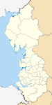
Cumbria Allerdale • Barrow-in-Furness • Carlisle • Copeland • Eden • South Lakeland
Greater Manchester Lancashire Blackburn with Darwen • Blackpool • Burnley • Chorley • Fylde • Hyndburn • Lancaster • Pendle • Preston • Ribble Valley • Rossendale • South Ribble • West Lancashire • Wyre
Merseyside Metropolitan counties and metropolitan districts Greater Manchester 
Merseyside South Yorkshire Tyne and Wear West Midlands West Yorkshire Categories:- Local government in Bolton
- Bolton
- Metropolitan boroughs
- Local government districts of North West England


Wikimedia Foundation. 2010.