- Ol Doinyo Lengai
-
Ol Doinyo Lengai 
Image of 1966 eruptionElevation 2,980 m (9,777 ft) Location Tanzania
 Ol Doinyo Lengai
Range Great Rift Valley Coordinates 02°45′52″S 34°54′58″E / 2.76444°S 34.91611°ECoordinates: 02°45′52″S 34°54′58″E / 2.76444°S 34.91611°E Geology Type Stratovolcano Last eruption 2010 (ongoing)[1][2] Climbing Easiest route Scramble Ol Doinyo Lengai is an active volcano located in the north of Tanzania and is part of the volcanic system of the Great Rift Valley in Eastern Africa. It is located in the eastern Rift Valley, south of both Lake Natron and Kenya. It is unique among active volcanoes in that it produces natrocarbonatite lava, a unique occurrence of volcanic carbonatite. Further, the temperature of its lava as it emerges is only around 510 °C (950 °F). A few older extinct carbonatite volcanoes are located nearby, including Homa Mountain.
Contents
Geology
"Ol Doinyo Lengai" means "The Mountain of God" in the Maasai language of the native people.[3] The record of eruptions on the mountain dates to 1883, and flows were also recorded between 1904 and 1910 and again between 1913 and 1915. A major eruption took place in June 1917, which resulted in volcanic ash being deposited about 48 kilometres away.
A similar eruption took place for several months in 1926 and between July and December 1940, resulting in the ash being deposited as far as Loliondo, which is 100 kilometres away. Several minor eruptions of lava were observed in 1954, 1955, 1958 the early 1960s.
When Ol Doinyo Lengai erupted on August 14, 1966, two geologists — J. B. Dawson and G. C. Clark — who visited the crater a week later, reported seeing “a thick column of black ash” that rose for approximately three thousand feet above the volcano and drifted away northwards towards Lake Natron. When the two climbed the cone-shaped vent, they reported seeing a continuous discharge of gas and whitish-grey ash and dust from the centre of the pit.
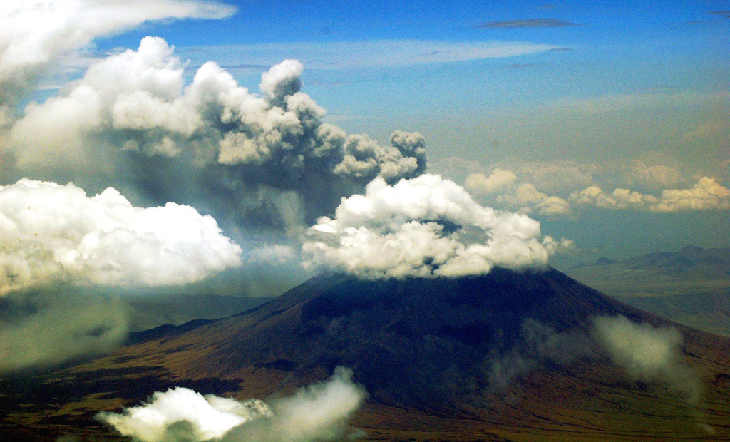
Volcanic activity in the mountain caused daily earth tremors in Kenya and Tanzania beginning on July 12, 2007. The latest to hit parts of Nairobi city was recorded on July 18, 2007 at 8.30pm (Kenyan Time). The strongest tremor measured 6.0 on the Richter scale. Geologists suspected that the sudden increase of tremors was indicative of the movement of magma through the Ol Doinyo Lengai. The volcano finally erupted on September 4, 2007, sending a plume of ash and steam at least 18 kilometers downwind and covering the north and west flanks in fresh lava flows. The eruption has continued intermittently into 2008, as of the end of February it was reported that the eruption appeared to be gathering strength, with a major outburst taking place on March 5. During April periods of inactivity have been followed by eruptions on April 8 and 17. Eruptive activity continued until late August 2008. A visit to the summit in September 2008 discovered that lava emission had resumed from two vents in the floor of the new crater. Visits to the crater in March/April 2009 showed that even this activity appears to have ceased.[4]
Lava
Whereas most lavas are rich in silicate minerals, the lava of Ol Doinyo Lengai is a carbonatite. It is rich in the rare sodium and potassium carbonates, nyerereite and gregoryite. Due to this unusual composition, the lava erupts at relatively low temperatures of approximately 500-600 degrees Celsius. This temperature is so low that the molten lava appears black in sunlight, rather than having the red glow common to most lavas. It is also much more fluid than silicate lavas, often less viscous than water. The sodium and potassium carbonate minerals of the lavas formed by Ol Doinyo Lengai are unstable at the Earth's surface and susceptible to rapid weathering, quickly turning from black to grey in color. The resulting volcanic landscape is different from any other in the world.
Gallery
-

Crater of the Ol Doinyo Lengai with recent lava flow, 15th. August 2007.
-

Ol Doinyo Lengai erupting in March 2008.
-

Ol Doinyo Lengai after an explosive eruption.
-

Image of the volcano sending a plume of ash and steam southward.
-

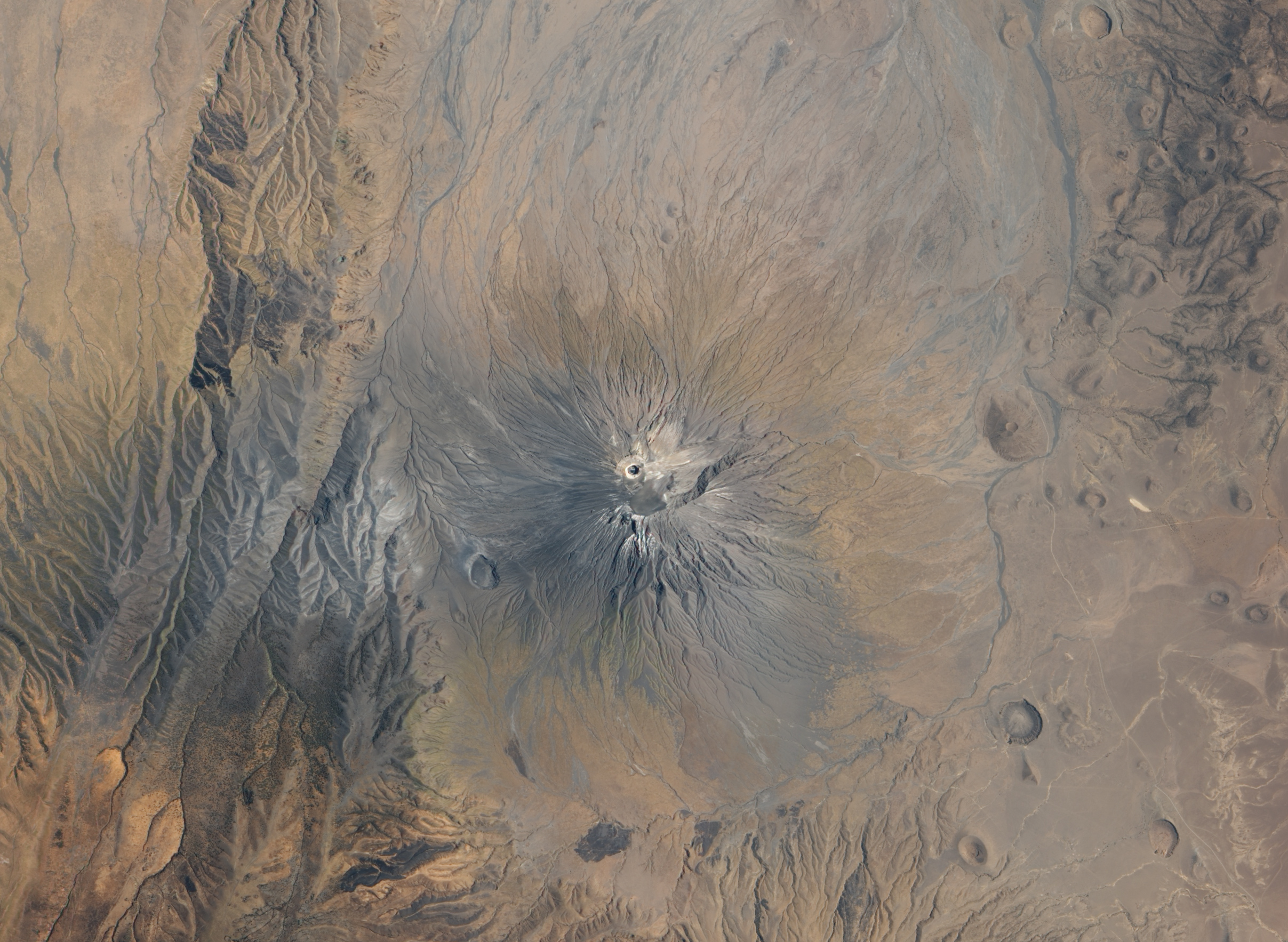
Aerial photo of Oldoinyo Lengai in 2011.
See also
References
- ^ "Ol Doinyo Lengai". Global Volcanism Program, Smithsonian Institution. http://www.volcano.si.edu/world/volcano.cfm?vnum=0202-12=.
- ^ Lengai 2007 (through November) News Archive, Website maintained by Frederick A. Belton, Middle Tennessee State University.
- ^ Northern Tanzania with Kilimanjaro and Zanzibar by Phillip Briggs 2006 page 194 ISBN 1-84162-146-3
- ^ Latest news at Lengai, Website maintained by Frederick A. Belton, Middle Tennessee State University.
External links
Categories:- Stratovolcanoes
- Volcanoes of the Great Rift Valley
- Volcanoes of Tanzania
- Mountains of Tanzania
- Active volcanoes
-


Wikimedia Foundation. 2010.